Widespread, life-threatening considerable flash flooding is expected in south-central Texas through at least Friday. Catastrophic river flooding and rapid rises on small streams, arroyos, and typically dry washes are expected in the Texas Hill Country. Wildfire smoke is impacting air quality across much of the Great Lakes region into the Northeast U.S. with Air Quality Alerts in effect. Read More >
From 2015: Those of us across northern and central South Dakota and west central Minnesota experienced another day of noticeable haze due to the smoke from Canadian wildfires, a good number of which are still out of control and fairly large. As of July 8th, according to Canada's National Wildland Fire Situation Report, 4,672 fires have ignited across Canada burning a total of 2,649,305 hectares of land (one hectare is about 2.5 football fields) so far in 2015. This is about the size of New Hampshire or a bit under the size of two of South Dakota's Black Hills. A sizeable amout of that has burned over the past two weeks, specifically over the provinces of Alberta and Saskatchewan (northwest of the Dakotas) which has led to great amounts of smoke. Here is a map of current active fires: https://cwfis.cfs.nrcan.gc.ca/interactive-map.
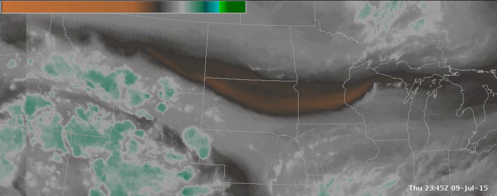
But why do we see the smoky haze out our windows today? Since the air of the atmosphere shares many similar characteristics with fluid motion, we sometimes observe areas in the upper atmosphere, where the jetstream lives, where there is basically little or no wind. I like to call them "dead zones" (think cell phone coverage areas), since air movement is pretty much non-existent. Since the atmosphere is boasting of "split flow" aloft, including a rather impressive "rex block" pattern over the western United States, one such "dead-zone" has developed and elongated itself from roughly northern Washington state all the way east across the plains to northern Wisconsin. When the jetstream is directing air currents southeastward from Canada, expect these bouts of smoke to continue. However, if your favorite weatherman says that the jetstream will start steering air through this region from the west or southwest, expect the smoke to go away. Keep this in mind as the fires responsible may be ongoing for weeks to come.
See the two satellite images below to see this dead-zone feature aloft. The black and white satellite image, visible satellite, is looking for clouds in the atmosphere.The grayish looking satellite image, water vapor, is looking for moisture in the middle and upper portions of the atmosphere. These images are from July 9, 2015.