Overview
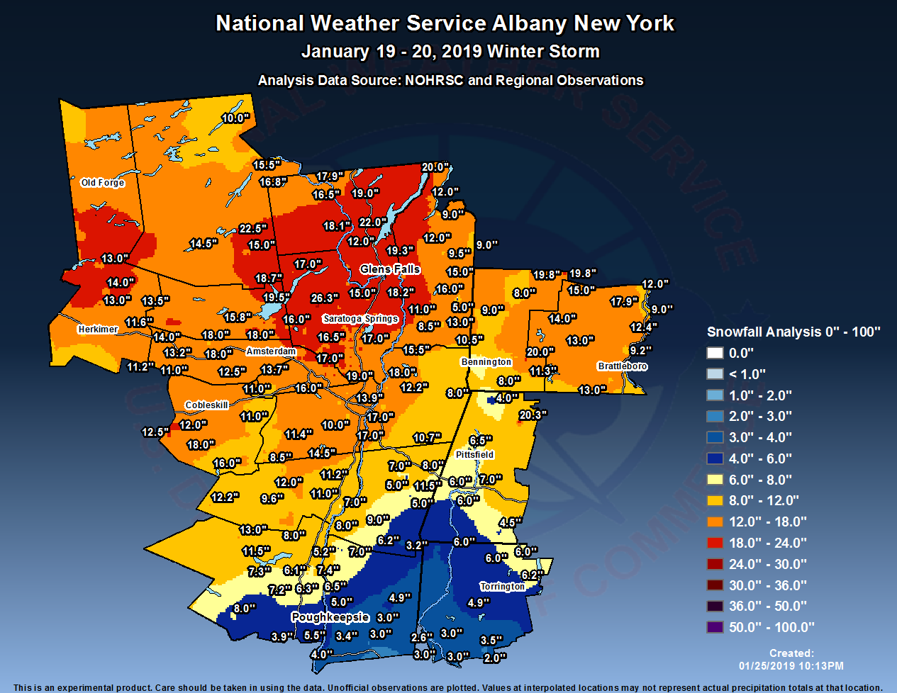
The largest snowstorm to date in the 2018-19 winter occurred on January 19th and 20th across eastern New York and western New England. Low pressure formed over the lower Mississippi Valley and lifted northeast across the Tennessee Valley during the night of the 19th before moving along the Mason-Dixon line on the 20th. Strong rising motion occurred as southerly winds aloft transported moist air northward, which was lifted over the cold airmass in place over eastern New York and western New England. Snowfall broke out during the afternoon of the 19th, continuing heavy at times into the evening and overnight hours before ending during the morning of the 20th. The strong southerly flow brought above-freezing air aloft into the region, causing the snow to turn to sleet as far north as the Capital District, northern Catskills, and southern Vermont for a time before turning back to snow. Further south, the air aloft was warm enough to turn the precipitation to freezing rain with ice accretion of one to three tenths of an inch over portions of the southeast Catskills, Mid-Hudson Valley, southern Taconics, southern Berkshires, and Litchfield Hills.
Snowfall totals were heaviest from the central Mohawk Valley into the southern Adirondacks and Lake George-Saratoga region where 1.5-2 foot totals were common. Three to six inches of snow and sleet along with some ice occurred over the Mid- Hudson Valley, Litchfield Hills, and southern Berkshires. The remainder of the region saw between 6 and 18 inches.
The snowfall resulted in the cancellation of many weekend activities along with numerous flights from Albany International Airport. Frigid temperatures followed the snow for Monday and Tuesday, January 21st-22nd, with wind chills falling to -20 to -40F across most of the region.
Snow/Ice
Public Information Statement
Spotter Reports
National Weather Service Albany NY
134 PM EST Mon Jan 21 2019

The following are unofficial observations taken during the past 30
hours for the storm that has been affecting our region. Appreciation
is extended to highway departments, cooperative observers, Skywarn
spotters and media for these reports. This summary also is available
on our home page at weather.gov/albany

********************STORM TOTAL SNOWFALL********************

LOCATION          STORM TOTAL     TIME/DATE   COMMENTS
                     SNOWFALL           OF
                     /INCHES/   MEASUREMENT

CONNECTICUT

...Litchfield County...
   Bakersville            6.2   700 AM  1/21  Co-Op Observer
   3 SW New Hartford      6.2   700 AM  1/21  CoCoRaHS
   Canaan                 6.0   432 PM  1/20  WeatherNet6
   Norfolk                6.0   800 AM  1/21  Co-Op Observer
   5 NNW Winsted          6.0   700 AM  1/21  CoCoRaHS
   2 NE Litchfield        4.9   730 AM  1/21  CoCoRaHS
   1 WNW Woodbury Cente   3.5   700 PM  1/20  Amateur Radio
   5 SSW New Milford      3.0   820 AM  1/20  CoCoRaHS
   New Milford            3.0   700 PM  1/20  Amateur Radio
   Roxbury                3.0   938 AM  1/20  Amateur Radio
   2 W New Milford        2.6  1030 AM  1/20  CoCoRaHS
   Woodbury Center        2.0   938 AM  1/20  Amateur Radio

MASSACHUSETTS

...Berkshire County...
   Savoy                 20.3  1053 PM  1/20  WeatherNet6
   Pittsfield             7.2   826 AM  1/20  Trained Spotter
   Lenoxdale              7.0   342 PM  1/20  Social Media
   1 NNW Pittsfield       6.5   800 AM  1/20  CoCoRaHS
   1 SE Housatonic        6.0   700 AM  1/21  CoCoRaHS
   3 NE Housatonic        6.0   600 AM  1/21  CoCoRaHS
   1 S Sandisfield        4.5  1058 AM  1/20  Social Media
   1 E Williamstown       4.0   700 AM  1/21  CoCoRaHS

NEW YORK

...Albany County...
   3 N Selkirk           17.0   700 AM  1/21  CoCoRaHS
   2 WSW Hampton Manor   17.0   631 PM  1/20  Broadcast Media
   Colonie               14.5   242 PM  1/20  Public
   Boght Corners         14.1   230 PM  1/20  NWS Employee
   Albany Intl AP        13.9   700 PM  1/20  ASOS
   Knox                  13.5   305 PM  1/20  WeatherNet6
   Latham                13.0  1033 AM  1/20  Social Media
   3 NW Guilderland      13.0   215 PM  1/20  NWS Employee
   2 WNW Guilderland     13.0   700 AM  1/21  CoCoRaHS
   1 WNW Albany          12.7   510 PM  1/20  NWS Employee
   2 W Albany            12.0   820 AM  1/20  Social Media
   5 WNW Westerlo        11.4   700 AM  1/21  CoCoRaHS
   2 S Colonie           11.2   700 AM  1/21  CoCoRaHS
   Albany                11.2   100 PM  1/20  NWS Albany Office
   1 NNW Colonie         11.0   825 AM  1/20  Trained Spotter
   Westmere              10.2   934 AM  1/20  Social Media
   Delmar                10.0   853 AM  1/20  Social Media

...Columbia County...
   4 SE Chatham          11.5   633 PM  1/20  Broadcast Media
   Livingston             9.0   619 PM  1/20  WeatherNet6
   3 N Austerlitz         8.0   550 PM  1/20  Elevation 1750 feet
   1 W Livingston         8.0   424 PM  1/20  Public
   Germantown             8.0   746 AM  1/20  WeatherNet6
   Chatham                7.0   508 PM  1/20  Public
   Taghkanic              6.2   823 AM  1/21  WeatherNet6
   5 SW Austerlitz        5.0   800 AM  1/21  CoCoRaHS
   Austerlitz             5.0   911 AM  1/20  WeatherNet6
   Ancramdale             3.2   515 PM  1/20  WeatherNet6

...Dutchess County...
   2 WSW Elizaville       7.0   427 PM  1/20  Trained Spotter
   2 SE Tivoli            6.0   826 AM  1/20  Trained Spotter
   1 NE Red Hook          5.7   700 AM  1/21  CoCoRaHS
   Poughkeepsie           5.5   700 AM  1/21  Co-Op Observer
   Red Hook               5.2   806 AM  1/20  WeatherNet6
   Hyde Park              5.0   937 AM  1/20  Trained Spotter
   3 SE Millbrook         4.9   700 AM  1/21  CoCoRaHS
   Fishkill               4.0   949 AM  1/20  Trained Spotter
   1 WSW Red Oaks Mill    3.4   827 AM  1/20  Trained Spotter
   Hopewell Junction      3.2  1242 PM  1/20  Trained Spotter
   2 ENE Hopewell Junct   3.0   900 AM  1/20  CoCoRaHS
   6 ESE Pleasant Valle   3.0   700 AM  1/21  CoCoRaHS

...Fulton County...
   Fishhouse             19.5   109 PM  1/20  WeatherNet6
   Fish House            19.5   639 PM  1/20  Broadcast Media
   Northville            18.7   400 PM  1/20  CoCoRaHS
   Johnstown             18.0   442 PM  1/20  WeatherNet6
   Perth                 18.0   229 PM  1/20  WeatherNet6
   4 WNW Galway          16.0   900 AM  1/21  CoCoRaHS
   Gloversville          15.8   602 PM  1/20  Public
   7 NW GLOVERSVILLE     15.6   800 AM  1/21  Co-Op Observer
   Broadalbin            14.0  1029 AM  1/20  Social Media

...Greene County...
   Greenville            14.5   641 PM  1/20  Broadcast Media
   Greenville Center     14.5  1130 AM  1/20  WeatherNet6
   Halcott Center        12.2   530 PM  1/20  WeatherNet6
   Freehold              12.0  1043 AM  1/20  Social Media
   4 NNE Cairo           11.2   530 AM  1/21  CoCoRaHS
   Cairo                 11.0   531 PM  1/20  WeatherNet6
   East Jewett            9.6   730 AM  1/21  Co-Op Observer
   Durham                 8.5   851 AM  1/20  WeatherNet6
   Catskill               7.0  1048 PM  1/20  WeatherNet6

...Hamilton County...
   5 NNW Wells           22.5   642 PM  1/20  Broadcast Media
   2 SW Indian Lake      15.5   820 AM  1/21  Co-Op Observer
   Wells                 15.0   314 PM  1/20  WeatherNet6
   Piseco                14.5   558 AM  1/21  WeatherNet6
   Long Lake             10.0   700 AM  1/21  CoCoRaHS

...Herkimer County...
   4 ENE Newport         14.0   900 AM  1/20  Social Media
   4 NNW Dolgeville      13.5   630 AM  1/21  CoCoRaHS
   Ohio                  13.0  1231 PM  1/20  Social Media
   8 NW Little Falls     13.0   918 AM  1/20  Social Media
   Dolgeville            11.6   331 PM  1/20  Trained Spotter
   Ilion                 10.2   700 AM  1/21  CoCoRaHS

...Montgomery County...
   Fonda                 18.0   612 PM  1/20  WeatherNet6
   Tribes Hill           14.2   644 PM  1/20  Broadcast Media
   St. Johnsville        14.0   843 AM  1/20  Social Media
   Amsterdam             13.8  1058 PM  1/20  WeatherNet6
   1 NW Amsterdam        13.8   830 AM  1/21  CoCoRaHS
   Fort Plain            13.2   700 AM  1/21  CoCoRaHS
   Palatine Bridge       13.0   605 PM  1/20  WeatherNet6
   Glen                  12.5   524 PM  1/20  WeatherNet6
   4 ENE East Springfie  11.2   800 AM  1/21  CoCoRaHS
   Hessville             11.0  1122 AM  1/20  WeatherNet6
   4 ESE Ephratah        10.0  1030 AM  1/20  CoCoRaHS

...Rensselaer County...
   Speigletown           18.0   440 PM  1/20  WeatherNet6
   Schaghticoke          15.5   800 PM  1/20  Social Media
   2 S Stillwater        14.7   829 PM  1/20  Emergency Manager
   Troy                  14.1   700 AM  1/21  CoCoRaHS
   Center Brunswick      12.2  1050 PM  1/20  WeatherNet6
   East Greenbush        12.0  1208 PM  1/20  Trained Spotter
   2 SSE Waterford       11.5   833 AM  1/20  Trained Spotter
   2 NE Troy             11.5   800 AM  1/21  CoCoRaHS
   5 E Waterford         11.4   700 AM  1/21  CoCoRaHS
   Waterford             11.0   749 AM  1/20  Social Media
   4 ESE Nassau          10.7   803 AM  1/21  CoCoRaHS
   2 SW Wyantskill        9.0   837 AM  1/20  Social Media
   Hoosick Falls          8.5   542 PM  1/20  WeatherNet6
   Berlin                 8.0   841 AM  1/20  Social Media

...Saratoga County...
   Lake Desolation       26.3  1135 PM  1/20  WeatherNet6
   2 SE Clifton Park     19.0   600 AM  1/21  CoCoRaHS
   1 W Gansevoort        18.2   600 AM  1/21  CoCoRaHS
   Edinburg              17.0   534 PM  1/20  Public
   Malta                 17.0  1049 PM  1/20  WeatherNet6
   Hickeys Corners       17.0   559 AM  1/21  Retired NWS Emp.
   1 ENE Alplaus         17.0   122 PM  1/20  Social Media
   2 ESE Ballston Spa    17.0   850 AM  1/21  CoCoRaHS
   3 W Day Center        17.0   700 AM  1/21  CoCoRaHS
   2 NNE Round Lake      16.9   830 AM  1/21  Trained Spotter
   Milton                16.5  1207 PM  1/20  Social Media
   Ballston Spa          16.5   632 AM  1/21  WeatherNet6
   2 S Clifton Park Cen  16.0   734 PM  1/20  Retired NWS Emp.
   Charlton              16.0   211 PM  1/20  WeatherNet6
   4 WNW Burnt Hills     15.5   449 PM  1/20  Social Media
   1 SSE Porter Corners  15.5   830 AM  1/21  CoCoRaHS
   Wilton                15.5   318 PM  1/20  Trained Spotter
   Corinth               15.0   423 PM  1/20  WeatherNet6
   Ballston Lake         15.0   140 PM  1/20  NWS Employee
   1 WSW Round Lake      14.5   800 AM  1/21  CoCoRaHS
   Galway                14.0   923 AM  1/20  Social Media
   Saratoga Springs      13.5   933 AM  1/21  WeatherNet6
   Clifton Park          13.0  1213 PM  1/20  Social Media
   3 NNW Malta           13.0  1000 AM  1/21  CoCoRaHS
   Mechanicville         12.5  1034 AM  1/20  Social Media

...Schenectady County...
   Niskayuna             17.0   114 PM  1/20  WeatherNet6
   1 SSW Aqueduct        16.2   216 PM  1/20  NWS Employee
   Schenectady           16.0   658 PM  1/20  WeatherNet6
   2 SE Niskayuna        15.2   900 AM  1/21  CoCoRaHS
   Rotterdam             15.0   800 AM  1/21  CoCoRaHS
   Scotia                15.0   209 PM  1/20  Public
   Glenville             15.0   219 PM  1/20  WeatherNet6
   Schenectady-GE Plot   13.8   254 PM  1/20  NWS Employee
   4 SSW Pattersonville  13.7   800 AM  1/21  CoCoRaHS
   1 NNE Hawthorne Hill  13.5   217 PM  1/20  NWS Employee
   1 E Niskayuna         12.0   854 AM  1/20  Social Media
   3 NNE Pattersonville  12.0  1014 AM  1/20  Trained Spotter
   Duanesburg            11.0   629 AM  1/21  WeatherNet6
   Delanson              11.0   700 AM  1/21  Co-Op Observer

...Schoharie County...
   Jefferson             18.0   623 PM  1/20  WeatherNet6
   Gilboa                16.0  1048 PM  1/20  WeatherNet6
   Charlotteville        12.5   553 PM  1/20  WeatherNet6
   Richmondville         12.0  1040 PM  1/20  WeatherNet6
   2 ESE Cobleskill      12.0   735 AM  1/21  Co-Op Observer
   Schoharie             11.0   730 AM  1/21  Co-Op Observer
   Cobleskill             9.0   121 PM  1/20  Trained Spotter

...Ulster County...
   Phoenicia             13.0   719 AM  1/21  WeatherNet6
   West Shokan           11.5   628 AM  1/21  WeatherNet6
   Ellenville             8.0   828 AM  1/20  Social Media
   Woodstock              8.0   854 AM  1/20  Social Media
   Kingston               7.4   427 PM  1/20  Public
   6 ESE West Shokan      7.3   900 AM  1/20  CoCoRaHS
   1 WNW Rosendale Vill   7.2   700 AM  1/21  CoCoRaHS
   Esopus                 6.5  1119 PM  1/20  Trained Spotter
   Ulster Park            6.3  1132 AM  1/20  WeatherNet6
   2 S Hurley             6.1   944 AM  1/21  CoCoRaHS
   Highland               4.7   700 AM  1/21  CoCoRaHS
   Plattekill             3.9   455 PM  1/20  Trained Spotter

...Warren County...
   Warrensburg           22.0   620 PM  1/20  WeatherNet6
   Hague                 20.0   845 PM  1/20  Social Media
   3 NNE Glens Falls     19.3   700 AM  1/21  CoCoRaHS
   Queensbury            19.2   600 PM  1/20  1.62" liquid equivalent
   2 WNW Chestertown     19.0   312 PM  1/20  NWS Employee
   2 WNW Warrensburg     18.1   820 AM  1/21  CoCoRaHS
   5 SE North Creek      17.9   700 AM  1/21  Co-Op Observer
   3 WSW North River     16.8  1240 PM  1/20  Trained Spotter
   3 W Chestertown       16.5   939 AM  1/20  Trained Spotter
   Lake Luzerne-Hadley   16.0  1036 AM  1/20  Social Media
   Glens Falls           16.0   405 PM  1/20  Meteorologist
   Lake George Villag    12.0   842 AM  1/20  Social Media

...Washington County...
   Hudson Falls          23.0   440 AM  1/21  WeatherNet6
   5 SE Argyle           16.0   644 PM  1/20  Broadcast Media
   Hebron                15.0   643 AM  1/21  WeatherNet6
   Fort Edward           15.0  1245 PM  1/20  Trained Spotter
   Cambridge             13.0  1000 PM  1/20  Trained Spotter
   3 ESE Huletts Landin  12.0   843 AM  1/20  Social Media
   Fort Ann              12.0   933 AM  1/20  Social Media
   Greenwich             11.0   412 PM  1/20  Social Media
   2 ESE Cambridge       10.5   512 PM  1/20  Trained Spotter
   Hartford               9.5  1214 PM  1/20  Social Media
   Whitehall              9.0   836 AM  1/20  Social Media
   Granville              9.0   932 AM  1/20  Social Media
   2 NNW Cambridge        8.5   906 AM  1/20  Trained Spotter
   Salam                  5.0   841 AM  1/20  WeatherNet6

VERMONT

...Bennington County...
   Woodford              20.0   653 AM  1/21  WeatherNet6
   1 WNW Weston          19.8   700 AM  1/21  CoCoRaHS
   Landgrove             19.8  1101 PM  1/20  WeatherNet6
   5 NW Readsboro        11.3   510 PM  1/20  Meteorologist
   West Arlington         9.0   547 AM  1/21  WeatherNet6
   Manchester             8.0   851 AM  1/20  Social Media
   Stamford               8.0   852 AM  1/20  Social Media

...Windham County...
   Athens                17.9   507 PM  1/20  Trained Spotter
   Windham               15.0   830 PM  1/20  Social Media
   Stratton              14.0  1210 PM  1/20  Social Media
   Halifax               13.0   402 PM  1/20  Social Media
   1 ESE West Wardsboro  13.0   920 AM  1/21  CoCoRaHS
   Marlboro              12.8   800 AM  1/21  Co-Op Observer
   2 ESE Jacksonville    12.5   823 AM  1/20  CoCoRaHS
   2 NNW Putney          12.4   800 AM  1/21  CoCoRaHS
   Brattleboro           12.0   849 AM  1/20  Social Media
   3 WSW Charlestown     12.0   700 AM  1/21  CoCoRaHS
   Guilford Center       11.0  1028 AM  1/20  Social Media
   1 SE Brattleboro      10.3   700 AM  1/21  CoCoRaHS
   3 SSW Putney           9.2   921 AM  1/20  Trained Spotter
   Bellows Falls          9.0  1015 AM  1/20  Social Media
Public Information Statement
Spotter Reports
National Weather Service Albany NY
151 PM EST Mon Jan 21 2019

The following are unofficial observations taken during the past 30
hours for the storm that has been affecting our region. Appreciation
is extended to highway departments, cooperative observers, Skywarn
spotters and media for these reports. This summary also is available
on our home page at weather.gov/albany

***********************STORM TOTAL ICE***********************

LOCATION          STORM TOTAL     TIME/DATE   COMMENTS
                          ICE           OF
                     /INCHES/   MEASUREMENT

CONNECTICUT

...Litchfield County...
   Roxbury               0.30   916 AM  1/20  Social Media
   New Milford           0.25   700 PM  1/20  Amateur Radio
   Woodbury Center       0.10   938 AM  1/20  Amateur Radio

MASSACHUSETTS

...Berkshire County...
   Windsor               0.15   849 AM  1/20  Social Media

NEW YORK

...Columbia County...
   Ancram                0.30   647 PM  1/20  Broadcast Media

...Dutchess County...
   Hyde Park             0.25   935 AM  1/20  Trained Spotter

...Ulster County...
   Plattekill            0.30   505 PM  1/20  Trained Spotter
   Wallkill              0.25  1150 AM  1/20  Social Media
   Esopus                0.15  1123 PM  1/20  Trained Spotter
   Kingston              0.10   428 PM  1/20  Public
Radar
KENX radar loop from 12:30 pm 19 January through 3:00 pm 20 January
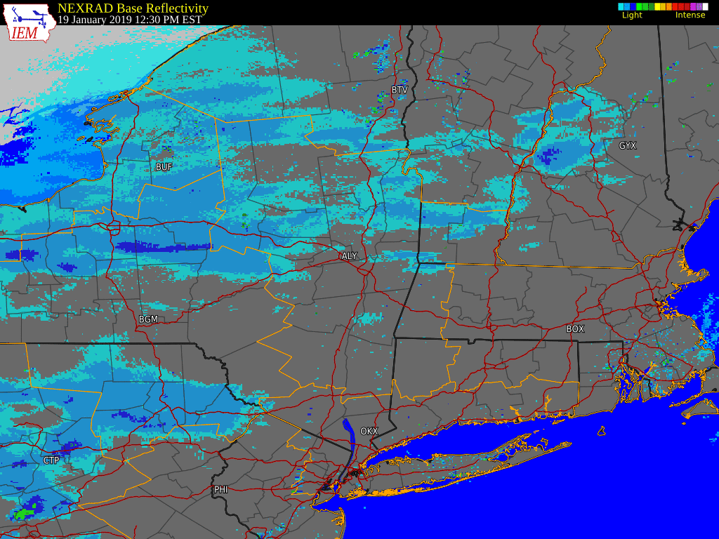 |
| Loop courtesy Iowa Environmental Mesonet |
Environment
Information may be added at a later date. |
Media use of NWS Web News Stories is encouraged! Please acknowledge the NWS as the source of any news information accessed from this site. |
|

