Overview
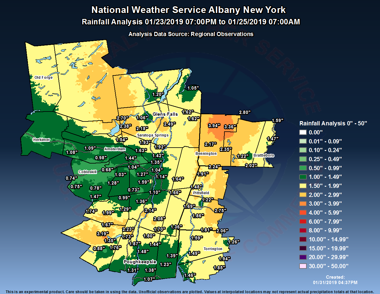
Following a heavy snowfall event on January 19-20 over much of eastern New York and western New England, a strong low pressure system tracking through southern Canada ushered in an unseasonably warm and moist airmass on January 24th. Temperatures surged into the 40s to mid-50s. Steady rainfall occurred during much of the 24th as a secondary low pressure system developed over the Mid- Atlantic and tracked into southern New England. One to two inches of rainfall occurred over much of the region, although a few reports of three to four inches were recorded over portions of southern Vermont, the southern Adirondacks, and the eastern Catskills. New daily rainfall records were set at Albany, Glens Falls, and Poughkeepsie.
The combination of the rainfall along with the mild temperatures melting some of the snow resulted in urban and poor drainage flooding over portions of the region along with minor to moderate river flooding in the Hoosic and Housatonic basins. Some ice jam flooding also occurred. Southern Vermont was particularly hard-hit, with several road closures due to flooding, a mudslide on Route 7A near Manchester, and evacuations of trailer parks in Brattleboro and Pownal. Numerous road closures also occurred due to flooding in Washington County, NY. In addition, seven vessels along the Hudson River near Troy were ripped from their moorings during the early morning of the 25th, likely by a surge of water and ice from upstream. Some of these vessels struck bridges, resulting in bridge closures during the morning rush hour, including the Patroon Island Bridge which carries I-90 over the Hudson.
Flooding
PRELIMINARY LOCAL STORM REPORT...SUMMARY
NATIONAL WEATHER SERVICE ALBANY NY
1204 AM EST FRI JAN 25 2019

..TIME...   ...EVENT...      ...CITY LOCATION...     ...LAT.LON...
..DATE...   ....MAG....      ..COUNTY LOCATION..ST.. ...SOURCE....
            ..REMARKS..

1044 AM     FLOOD            2 SW DALTON             42.46N  73.19W
01/24/2019                   BERKSHIRE          MA   NEWSPAPER

            HUBBORD AVE CLOSED DUE TO DEEP PONDING OF WATER

0119 PM     FLOOD            ARLINGTON               43.07N  73.15W
01/24/2019                   BENNINGTON         VT   EMERGENCY MNGR

            MUDSLIDE REPORTED ON THE SOUTHBOUND SIDE OF RT7A NEAR
            RED MOUNTAIN ROAD.

0211 PM     FLOOD            FONDA                   42.95N  74.38W
01/24/2019                   MONTGOMERY         NY   EMERGENCY MNGR

            FLOODING IN VILLAGE OF FONDA IN THE AREA OF MIDWAY
            ALLEY, BROADWAY AND W. MAIN STREET

0253 PM     FLOOD            1 ENE CAMBRIDGE         43.03N  73.36W
01/24/2019                   WASHINGTON         NY   911 CALL CENTER

            HOUSE EVACUATED DUE TO FLOODING

0253 PM     FLOOD            4 NNW GRANVILLE         43.46N  73.28W
01/24/2019                   WASHINGTON         NY   911 CALL CENTER

            ICE JAM ON METTAWEE RIVER NEAR GRANVILLE

0330 PM     FLOOD            HARWINTON               41.77N  73.06W
01/24/2019                   LITCHFIELD         CT   SOCIAL MEDIA

            ROAD CLOSURE DUE TO FLOODING FROM LEADMINE BROOK

0427 PM     FLOOD            2 ESE HURLEY            41.90N  74.02W
01/24/2019                   ULSTER             NY   OTHER FEDERAL

            ROAD CLOSURE NY 213 BETWEEN CREEKS LOCKS ROAD AND
            MOUNTAIN ROAD DUE TO FLOODING.

0436 PM     FLOOD            2 W GLENS FALLS AIRPORT 43.34N  73.64W
01/24/2019                   WARREN             NY   TRAINED SPOTTER

            FLOODING OF HALFWAY BROOK AT MEADOWBROOK ROAD.

0445 PM     FLOOD            1 E HILLSDALE           42.18N  73.51W
01/24/2019                   COLUMBIA           NY   OTHER FEDERAL

            NY 23 CLOSED BETWEEN NY 22 AND YONDERVIEW ROAD DUE TO
            FLOODING.

0458 PM     FLOOD            1 NNW ARLINGTON         43.08N  73.16W
01/24/2019                   BENNINGTON         VT   PUBLIC

            BATTENKILL RIVER IN ARLINGTON OVER ITS BANKS AND
            FLOODING. WATER APPROACHING RESIDENCE.

0458 PM     FLOOD            1 SSW ARLINGTON         43.05N  73.16W
01/24/2019                   BENNINGTON         VT   PUBLIC

            BATTENKILL RIVER IN ARLINGTON, VT IS OVER ITS BANKS AND
            LEADING TO FLOODING IN NEARBY HOMES.

0700 PM     FLOOD            3 W SARATOGA SPRINGS    43.08N  73.83W
01/24/2019                   SARATOGA           NY   SOCIAL MEDIA

            NY-ROUTE 29 WESTBOUND AT BROOK ROAD IN CITY OF SARATOGA
            SPRINGS CLOSED DUE TO FLOODING.
PRELIMINARY LOCAL STORM REPORT
NATIONAL WEATHER SERVICE ALBANY NY
522 AM EST FRI JAN 25 2019

..TIME...   ...EVENT...      ...CITY LOCATION...     ...LAT.LON...
..DATE...   ....MAG....      ..COUNTY LOCATION..ST.. ...SOURCE....
            ..REMARKS..

0121 PM     FLOOD            4 S CATSKILL            42.16N  73.88W
01/24/2019                   COLUMBIA           NY   DEPT OF HIGHWAYS

            NY 9G - ROAD CLOSED - SOUTHBOUND AT CAMP CREEK ROAD AND
            NORTHBOUND AT MAPLE AVE

0200 PM     FLOOD            1 SSW MANCHESTER CENTER 43.17N  73.05W
01/24/2019                   BENNINGTON         VT   NEWSPAPER

            ICE JAM ON BOURN BROOK CAUSED FLOODING ON RICHVILLE
            ROAD RESULTING IN A ROAD CLOSURE BETWEEN UNION STREET TO
            EAST MANCHESTER ROAD. TIME ESTIMATED.

0200 PM     FLOOD            LONDONDERRY             43.23N  72.80W
01/24/2019                   WINDHAM            VT   NEWSPAPER

            CAR STUCK ON ROUTE 100 IN 16 INCHES OF WATER. ROAD
            CLOSED. TIME ESTIMATED.

0200 PM     FLOOD            1 N WEST BRATTLEBORO    42.87N  72.61W
01/24/2019                   WINDHAM            VT   FIRE DEPT/RESCUE

            FLOODING ALONG THE WHETSTONE BROOK WITH WATER
            SURROUNDING A TRAILER PARK. RESIDENTS WERE EVACUATED.
PRELIMINARY LOCAL STORM REPORT
NATIONAL WEATHER SERVICE ALBANY NY
900 PM EST FRI JAN 25 2019

..TIME...   ...EVENT...      ...CITY LOCATION...     ...LAT.LON...
..DATE...   ....MAG....      ..COUNTY LOCATION..ST.. ...SOURCE....
            ..REMARKS..

0828 AM     FLOOD            1 WNW GREENWICH         43.09N  73.52W
01/24/2019                   WASHINGTON         NY   911 CALL CENTER

            ROAD CLOSED DUE TO FLOODING

0230 PM     FLOOD            2 SE GREENWICH          43.07N  73.47W
01/24/2019                   WASHINGTON         NY   911 CALL CENTER

            ROAD CLOSED DUE TO FLOODING

0230 PM     FLOOD            3 E STILLWATER          42.95N  73.58W
01/24/2019                   WASHINGTON         NY   911 CALL CENTER

            ROAD CLOSED DUE TO FLOODING.

0257 PM     FLOOD            1 W CAMBRIDGE           43.03N  73.40W
01/24/2019                   WASHINGTON         NY   911 CALL CENTER

            ROAD CLOSED DUE TO FLOODING

0306 PM     FLOOD            1 S SALEM               43.17N  73.33W
01/24/2019                   WASHINGTON         NY   911 CALL CENTER

            ROAD CLOSED DUE TO FLOODING

0408 PM     FLOOD            4 SW HEBRON             43.26N  73.37W
01/24/2019                   WASHINGTON         NY   911 CALL CENTER

            ROAD CLOSED DUE TO FLOODING

0752 PM     FLOOD            3 SE WHITEHALL          43.53N  73.39W
01/24/2019                   WASHINGTON         NY   911 CALL CENTER

            ROAD CLOSED DUE TO FLOODING
Radar
KENX radar loop from 3:30 pm on January 23rd through 7:00 pm on January 24th
.gif) |
| Loop courtesy Iowa Environmental Mesonet |
Rain Reports
Public Information Statement
Spotter Reports
National Weather Service Albany NY
327 PM EST Sat Jan 26 2019

The following are unofficial observations for the storm that impacted
the region on January 24 & 25, 2019. Appreciation is extended to
highway departments, cooperative observers, Skywarn spotters and
media for these reports. This summary also is available on our home
page at weather.gov/albany

********************STORM TOTAL RAINFALL********************

LOCATION          STORM TOTAL     TIME/DATE   COMMENTS
                     RAINFALL           OF
                     /INCHES/   MEASUREMENT

CONNECTICUT

...Litchfield County...
   5 NNW Winsted         2.06   700 AM  1/25  CoCoRaHS
   Thomaston Dam         1.94   700 AM  1/25  Co-Op Observer
   1 WNW Oakville        1.85   715 AM  1/25  CoCoRaHS
   3 SW New Hartford     1.84   700 AM  1/25  CoCoRaHS
   3 WNW Norfolk         1.81   700 AM  1/25  CoCoRaHS
   Bakersville           1.71   700 AM  1/25  Co-Op Observer
   Norfolk               1.59   800 AM  1/25  Co-Op Observer
   4 SSW Cornwall Bridg  1.49   700 AM  1/25  CoCoRaHS
   5 SSW New Milford     1.46   800 AM  1/25  CoCoRaHS
   1 NNW New Hartford    1.26   700 AM  1/25  CoCoRaHS

MASSACHUSETTS

...Berkshire County...
   Becket                2.75   514 PM  1/24  WeatherNet6
   Pittsfield Municipal  2.24   654 AM  1/25  ASOS
   1 E Williamstown      2.24   700 AM  1/25  CoCoRaHS
   Harriman-and-west Ai  1.91   652 AM  1/25  ASOS
   1 SE Housatonic       1.86   700 AM  1/25  CoCoRaHS
   3 NE Housatonic       1.69   600 AM  1/25  CoCoRaHS
   1 NNW Pittsfield      1.48   700 AM  1/25  CoCoRaHS
   2 ESE Williamstown    1.44   500 PM  1/24  CoCoRaHS
   Lenoxdale             1.22   515 PM  1/24  Co-Op Observer

NEW YORK

...Albany County...
   3 N Selkirk           1.59   700 AM  1/25  CoCoRaHS
   Albany Intl Ap        1.35   651 AM  1/25  ASOS
   5 WNW Westerlo        1.28   700 AM  1/25  CoCoRaHS
   2 S Colonie           1.27   700 AM  1/25  CoCoRaHS
   1 NNW Ravena          1.10   730 AM  1/25  CoCoRaHS
   Albany                1.04   700 AM  1/25  CoCoRaHS
   2 WNW Guilderland     1.04   700 AM  1/25  CoCoRaHS
   2 SSW Altamont        1.03   655 AM  1/25  CoCoRaHS
   Alcove Dam            0.73   725 AM  1/25  Co-Op Observer

...Columbia County...
   Livingston            2.08   700 AM  1/25  CoCoRaHS
   Taghkanic             1.70   557 PM  1/24  WeatherNet6
   Ancramdale            1.36   557 AM  1/25  WeatherNet6

...Dutchess County...
   Red Hook              1.80   517 PM  1/24  WeatherNet6
   1 NE Red Hook         1.65   700 AM  1/25  CoCoRaHS
   4 ENE Staatsburg      1.44   700 AM  1/25  CoCoRaHS
   3 SE Millbrook        1.39   700 AM  1/25  CoCoRaHS
   Red Oaks Mill         1.38   513 AM  1/25  CoCoRaHS
   1 NNE Wappingers Fal  1.31   900 AM  1/25  CoCoRaHS
   2 NE Millbrook        1.27   600 AM  1/25  CoCoRaHS
   Hudson Valley Region  1.23   653 AM  1/25  ASOS
   6 ESE Pleasant Valle  1.23   700 AM  1/25  CoCoRaHS
   Poughkeepsie          1.22   700 AM  1/25  Co-Op Observer
   1 NE Fishkill         1.07   700 AM  1/25  CoCoRaHS
   1 WSW Red Oaks Mill   1.05   500 AM  1/25  CoCoRaHS

...Fulton County...
   Northville            2.70   500 PM  1/24  CoCoRaHS
   Fishhouse             2.38   449 PM  1/24  WeatherNet6
   Perth                 1.54   500 PM  1/24  WeatherNet6

...Greene County...
   Catskill              2.14   558 AM  1/25  WeatherNet6
   West Kill             1.99   256 PM  1/24  WeatherNet6
   Halcott Center        1.74   746 PM  1/24  WeatherNet6
   4 NNE Cairo           1.36   530 AM  1/25  CoCoRaHS
   East Jewett           1.29   630 AM  1/25  Co-Op Observer
   7 SSE Westerlo        0.99   500 AM  1/25  CoCoRaHS

...Montgomery County...
   Palatine Bridge       1.09   516 PM  1/24  WeatherNet6
   Hessville             1.08  1237 PM  1/24  WeatherNet6
   Glen                  0.98  1055 PM  1/24  WeatherNet6
   Amsterdam             0.87  1055 PM  1/24  WeatherNet6

...Rensselaer County...
   2 NE Troy             1.68   700 AM  1/25  CoCoRaHS
   5 E Waterford         1.66   700 AM  1/25  CoCoRaHS
   4 ESE Nassau          1.66   807 AM  1/25  CoCoRaHS
   Averill Park          1.64   800 AM  1/25  CoCoRaHS
   Troy                  1.30   700 AM  1/25  Co-Op Observer
   Speigletown           1.25   438 PM  1/24  WeatherNet6
   2 SW Wyantskill       1.14   705 AM  1/25  CoCoRaHS

...Saratoga County...
   1 W Gansevoort        2.49   600 AM  1/25  CoCoRaHS
   Lake Desolation       2.18   609 PM  1/24  WeatherNet6
   2 ESE Ballston Spa    1.93   750 AM  1/25  CoCoRaHS
   2 NNE Round Lake      1.92   700 AM  1/25  CoCoRaHS
   Saratoga Springs      1.87   600 AM  1/25  CoCoRaHS
   1 WSW Round Lake      1.63   800 AM  1/25  CoCoRaHS
   Malta                 1.50  1045 PM  1/24  WeatherNet6
   2 SE Clifton Park     1.42   600 AM  1/25  CoCoRaHS

...Schenectady County...
   Schenectady           1.44   300 PM  1/24  WeatherNet6
   2 SE Niskayuna        0.86   900 AM  1/25  CoCoRaHS
   Rotterdam             0.53   900 AM  1/25  CoCoRaHS
   Niskayuna             0.50   700 AM  1/25  Co-Op Observer

...Schoharie County...
   North Blenheim        1.47   737 AM  1/24  WeatherNet6
   7 N North Blenheim    0.78   800 AM  1/25  Co-Op Observer
   Charlotteville        0.75   552 PM  1/24  WeatherNet6
   Richmondville         0.74   414 AM  1/25  WeatherNet6
   Schoharie             0.68   730 AM  1/25  Co-Op Observer
   2 ESE Cobleskill      0.60   735 AM  1/25  Co-Op Observer

...Ulster County...
   West Shokan           3.19   417 AM  1/25  WeatherNet6
   2 NW Lake Katrine     2.23   700 AM  1/25  CoCoRaHS
   2 S Hurley            1.87   700 AM  1/25  CoCoRaHS
   1 WNW Rosendale Vill  1.76   700 AM  1/25  CoCoRaHS
   Lincoln Park          1.73   700 AM  1/25  CoCoRaHS
   Phoenicia             1.67   605 AM  1/25  Co-Op Observer
   Highland              1.50   700 AM  1/25  CoCoRaHS
   Esopus                1.48   450 PM  1/24  WeatherNet6
   6 ESE West Shokan     1.35   800 AM  1/25  CoCoRaHS
   1 WSW Staatsburg      1.06   700 AM  1/25  CoCoRaHS
   3 N Kerhonkson        0.88   700 AM  1/25  CoCoRaHS

...Warren County...
   Floyd Bennett Memori  1.86   653 AM  1/25  ASOS
   Warrensburg           1.20   535 PM  1/24  WeatherNet6
   Lake Luzerne          1.06   531 AM  1/25  WeatherNet6

...Washington County...
   5 SW NORTH HEBRON     1.62   700 AM  1/25  Co-Op Observer
   Hebron                1.62   642 AM  1/25  WeatherNet6
   Whitehall             1.05   800 AM  1/25  Co-Op Observer

VERMONT

...Bennington County...
   Manchester            3.94   450 PM  1/24  WeatherNet6
   1 E Manchester Cente  3.36   700 AM  1/25  CoCoRaHS
   Landgrove             2.80  1046 PM  1/24  WeatherNet6
   Woodford              2.35   502 PM  1/24  WeatherNet6
   2 ENE North Benningt  2.17   600 AM  1/25  CoCoRaHS

...Windham County...
   2 ESE Jacksonville    2.02   810 AM  1/25  CoCoRaHS
   3 WSW Charlestown     1.59   700 AM  1/25  CoCoRaHS
   1 SE Brattleboro      1.53   700 AM  1/25  CoCoRaHS
   2 NNW Putney          1.47   700 AM  1/25  CoCoRaHS
   Marlboro              1.22   700 AM  1/25  Co-Op Observer
 |
Media use of NWS Web News Stories is encouraged! Please acknowledge the NWS as the source of any news information accessed from this site. |
|

