Overview
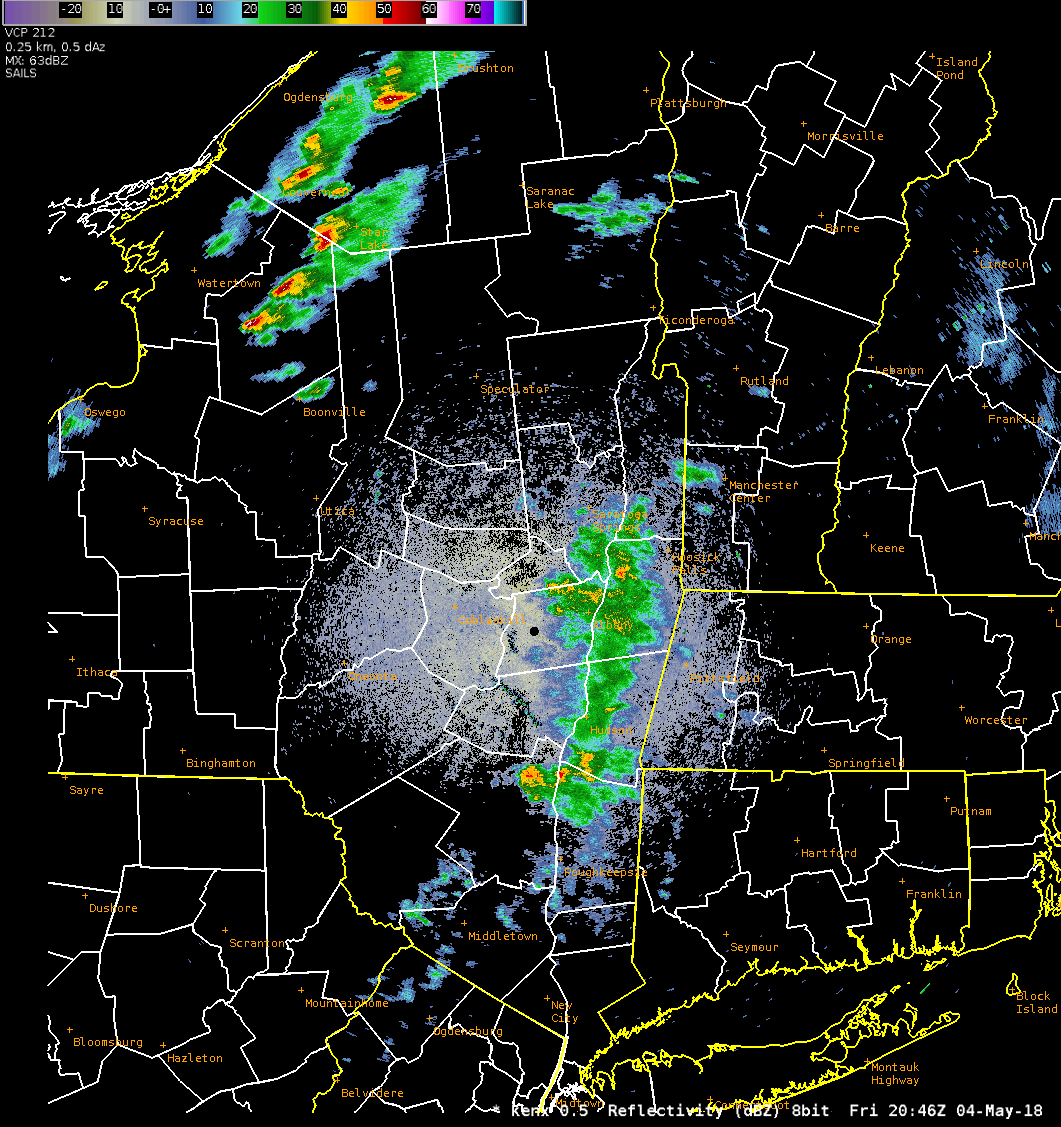
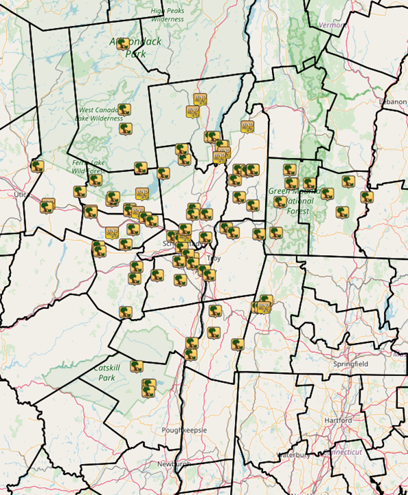
A line of thunderstorms formed over western New York along a strong cold front during the afternoon of May 4th. The storms moved eastward across eastern New York and western New England between 6:30 and 10 pm, resulting in numerous reports of trees and wires down. Wind gusts up to 61 mph were observed, though they were likely higher in some spots. A few concentrated swaths of wind damage, possibly associated with microbursts, occurred in Johnstown, NY (Fulton County) and Cambridge, NY (Washington County). Several large trees were down on houses and cars in these areas. Over 100,000 people lost power during the event.Peak Wind Gusts
Location                     Speed     Time/Date       Lat/Lon/Elev (ft.)

...Connecticut...

...Litchfield County...
2 ESE Torrington             32 MPH    1212 AM 05/05   41.81N/73.09W/967

...Massachusetts...

...Berkshire County...
Pittsfield Municipal Airport 58 MPH    0924 PM 05/04   42.43N/73.29W/1194
Harriman-and-west Airport    45 MPH    1118 PM 05/04   42.70N/73.17W/653
3 SW Williamstown            41 MPH    0219 AM 05/05   42.67N/73.24W/997
2 WSW East Windsor           41 MPH    0320 AM 05/05   42.47N/73.02W/1894
2 SE Adams                   38 MPH    0222 AM 05/05   42.60N/73.10W/1555
2 NNW Sheffield              37 MPH    0110 AM 05/05   42.14N/73.36W/662
3 SW Williamstown            32 MPH    0219 AM 05/05   42.66N/73.24W/918
1 NE Great Barrington        30 MPH    0947 PM 05/04   42.21N/73.34W/698

...New York...

...Albany County...
2 W Voorheesville            51 MPH    0830 PM 05/04   42.65N/73.98W/377
Albany Intl Ap               46 MPH    0828 PM 05/04   42.75N/73.80W/275
2 NE Preston Hollow          44 MPH    1020 PM 05/04   42.47N/74.17W/1247
2 SSE Delmar                 34 MPH    0843 PM 05/04   42.59N/73.81W/160
Colonie                      33 MPH    0830 PM 05/04   42.73N/73.84W/337

...Columbia County...
1 NW Kinderhook              46 MPH    0905 PM 05/04   42.41N/73.72W/238
Chatham                      45 MPH    0914 PM 05/04   42.37N/73.60W/436
2 NE Copake                  45 MPH    0915 PM 05/04   42.14N/73.52W/685
2 E Claverack                33 MPH    0927 PM 05/04   42.21N/73.67W/541

...Dutchess County...
1 ENE Cornwall On Hudson     44 MPH    1003 PM 05/04   41.46N/73.99W/63
Hudson Valley Regional Airpo 41 MPH    1011 PM 05/04   41.63N/73.88W/164
6 ESE Pleasant Valley        39 MPH    1011 PM 05/04   41.68N/73.72W/643
Red Hook                     34 MPH    1115 PM 05/04   42.00N/73.88W/212
2 NE Beacon                  31 MPH    0950 PM 05/04   41.53N/73.95W/295

...Fulton County...
2 ESE Johnstown              53 MPH    0737 PM 05/04   43.00N/74.33W/880
2 SSE Broadalbin             47 MPH    1053 PM 05/04   43.03N/74.18W/3051
4 N Saint Johnsville         37 MPH    0940 PM 05/04   43.06N/74.67W/1181
4 ESE Cranberry Creek        37 MPH    1115 PM 05/04   43.12N/74.15W/853

...Hamilton County...
1 ESE Eagle Bay              46 MPH    0647 PM 05/04   43.75N/74.79W/1715
1 ENE Indian Lake            41 MPH    0925 PM 05/04   43.79N/74.24W/1621

...Herkimer County...
1 WNW Herkimer               54 MPH    0705 PM 05/04   43.04N/75.01W/713
3 ENE Cold Brook             44 MPH    0700 PM 05/04   43.26N/74.98W/1421
Big Moose                    33 MPH    0900 PM 05/04   43.82N/74.90W/2139
Dolgeville                   31 MPH    0955 PM 05/04   43.11N/74.77W/820

...Montgomery County...
2 N Tribes Hill              60 MPH    0740 PM 05/04   42.98N/74.30W/745
4 ENE East Springfield       52 MPH    1150 PM 05/04   42.86N/74.72W/1043
3 ESE Canajoharie            51 MPH    0740 PM 05/04   42.87N/74.51W/655
1 ESE Hagaman                30 MPH    1205 AM 05/05   42.96N/74.13W/757

...Rensselaer County...
5 ESE Waterford              50 MPH    0850 PM 05/04   42.77N/73.58W/912
3 WSW Hoosick Falls          46 MPH    1056 PM 05/04   42.87N/73.41W/856
1 W Schaghticoke             43 MPH    0825 PM 05/04   42.90N/73.61W/323
3 ESE Castleton-on-Hudso     42 MPH    0900 PM 05/04   42.51N/73.69W/344
2 WSW Hancock                40 MPH    0915 PM 05/04   42.53N/73.36W/950
2 ENE Wyantskill             32 MPH    1057 PM 05/04   42.71N/73.61W/505
1 SE Menands                 32 MPH    0831 PM 05/04   42.67N/73.71W/419

...Saratoga County...
2 S Rock City Falls          42 MPH    0814 PM 05/04   43.02N/73.91W/432
1 W Edinburg                 42 MPH    1000 PM 05/04   43.23N/74.11W/1065
1 WSW Milton                 39 MPH    1135 PM 05/04   43.02N/73.87W/395
2 S Round Lake               36 MPH    0824 PM 05/04   42.90N/73.80W/295
Saratoga Springs             36 MPH    0835 PM 05/04   43.06N/73.78W/309
Hudson Falls                 34 MPH    1128 PM 05/04   43.30N/73.60W/764
1 NE Schuylerville           33 MPH    0825 PM 05/04   43.12N/73.58W/103
4 W Gansevoort               32 MPH    1054 PM 05/04   43.21N/73.73W/419

...Schenectady County...
Schenectady County Airport   58 MPH    0814 PM 05/04   42.85N/73.93W/0
East Glenville               58 MPH    0814 PM 05/04   42.85N/73.93W/377
1 N Schenectady              51 MPH    0810 PM 05/04   42.82N/73.93W/344
2 SW Mariaville              43 MPH    0810 PM 05/04   42.80N/74.17W/1368

...Schoharie County...
1 W Cobleskill               48 MPH    1000 PM 05/04   42.68N/74.51W/1076
2 ESE Cobleskill             48 MPH    0758 PM 05/04   42.66N/74.43W/1476
1 NW Cobleskill              33 MPH    0857 PM 05/04   42.70N/74.50W/1319

...Ulster County...
1 NNE Wallkill               35 MPH    0940 PM 05/04   41.63N/74.15W/353
Port Ewen                    33 MPH    0935 PM 05/04   41.90N/73.97W/190
6 NNW Sundown                32 MPH    0850 PM 05/04   41.98N/74.52W/1915
1 SSW New Paltz              31 MPH    1046 PM 05/04   41.73N/74.09W/339
3 WSW Tillson                30 MPH    0825 PM 05/04   41.80N/74.12W/633

...Warren County...
Floyd Bennett Memorial Airpo 61 MPH    0813 PM 05/04   43.34N/73.61W/321
9 NW Bolton Landing          58 MPH    1030 PM 05/04   43.65N/73.78W/1089
1 NE Corinth                 43 MPH    1053 PM 05/04   43.26N/73.81W/819

...Washington County...
5 S Whitehall                54 MPH    0825 PM 05/04   43.49N/73.42W/119
4 N Argyle                   38 MPH    0828 PM 05/04   43.30N/73.49W/262
Granville                    32 MPH    0105 AM 05/05   43.40N/73.27W/419

...Vermont...

...Bennington County...
Bennington State Airport     53 MPH    0841 PM 05/04   42.89N/73.25W/826
1 NNE Old Bennington         53 MPH    0850 PM 05/04   42.91N/73.20W/657
3 WSW Peru                   47 MPH    1140 PM 05/04   43.21N/72.96W/1928
4 ESE Woodford State Park    44 MPH    1131 PM 05/04   42.86N/72.96W/2802
6 NNE Stratton               38 MPH    1122 PM 05/04   43.13N/72.87W/2293
3 WSW Woodford State Park    37 MPH    0851 PM 05/04   42.88N/73.09W/2395
2 W Manchester               32 MPH    0831 PM 05/04   43.17N/73.11W/3780

...Windham County...
5 NNW Wilmington             38 MPH    0750 PM 05/04   42.94N/72.89W/2099
Wilmington                   36 MPH    0140 AM 05/05   42.87N/72.89W/1492
Brattleboro                  32 MPH    0920 PM 05/04   42.87N/72.57W/374
2 SSW Putney                 31 MPH    0925 PM 05/04   42.94N/72.53W/354
2 NW Vernon                  30 MPH    0931 PM 05/04   42.81N/72.57W/632
&&
Radar:
 |
 |
| Loop from KENX radar from 4:45 pm to 9:30 pm | Loop of KENX radar from 4:45 pm to 9:30 pm with warnings issued by WFO Albany |
Storm Reports
PRELIMINARY LOCAL STORM REPORT...SUMMARY
NATIONAL WEATHER SERVICE ALBANY NY
124 PM EDT SAT MAY 05 2018
..TIME... ...EVENT... ...CITY LOCATION... ...LAT.LON...
..DATE... ....MAG.... ..COUNTY LOCATION..ST.. ...SOURCE....
..REMARKS..
0656 PM TSTM WND DMG 3 NW POLAND 43.26N 75.11W
05/04/2018 HERKIMER NY 911 CALL CENTER
SEVERAL TREES DOWN.
0658 PM TSTM WND DMG LONG LAKE 43.97N 74.42W
05/04/2018 HAMILTON NY 911 CALL CENTER
TREES DOWN
0705 PM TSTM WND GST 1 WNW HERKIMER 43.04N 75.02W
05/04/2018 M54 MPH HERKIMER NY NYS MESONET
0715 PM TSTM WND DMG 1 NNE DOLGEVILLE 43.11N 74.77W
05/04/2018 HERKIMER NY 911 CALL CENTER
TREES AND WIRES DOWN.
0718 PM TSTM WND DMG 1 N ILION 43.02N 75.04W
05/04/2018 HERKIMER NY 911 CALL CENTER
TREES DOWN BLOCKING WEST RIVER STREET.
0721 PM TSTM WND DMG ST. JOHNSVILLE 43.00N 74.68W
05/04/2018 MONTGOMERY NY SOCIAL MEDIA
LARGE TREE AND WIRES DOWN.
0723 PM TSTM WND DMG 2 WNW SPECULATOR 43.59N 74.41W
05/04/2018 HAMILTON NY DEPT OF HIGHWAYS
TREES AND WIRES DOWN ON ROUTE 30 BETWEEN SPECULATOR AND
INDIAN LAKE, RESULTING IN A CLOSURE
0725 PM TSTM WND DMG 7 S SPECULATOR 43.48N 74.40W
05/04/2018 HAMILTON NY 911 CALL CENTER
TREE DOWN ALONG ROUTE 8
0726 PM TSTM WND DMG 5 NNE EPHRATAH 43.06N 74.51W
05/04/2018 FULTON NY PUBLIC
LARGE AREA OF MUTIPLE PINE TREES DOWN.
0730 PM TSTM WND DMG 1 SSW ST. JOHNSVILLE 42.99N 74.68W
05/04/2018 MONTGOMERY NY 911 CALL CENTER
TREES DOWN.
0733 PM TSTM WND DMG 4 SSW CAROGA LAKE 43.08N 74.50W
05/04/2018 FULTON NY 911 CALL CENTER
TREE BLOCKING ONE LANE OF ROUTE 10A.
0735 PM TSTM WND DMG 2 E STRATFORD 43.18N 74.64W
05/04/2018 FULTON NY 911 CALL CENTER
TREES DOWN.
0737 PM TSTM WND DMG JOHNSTOWN 43.01N 74.37W
05/04/2018 FULTON NY EMERGENCY MNGR
NUMEROUS TREES DOWN IN JOHNSTOWN, FROM PLEASANT AVE
EAST TO RTE 30A.
0737 PM TSTM WND DMG 6 WNW NORTHVILLE 43.25N 74.28W
05/04/2018 HAMILTON NY 911 CALL CENTER
TREES DOWN IN TOWN OF BENSON
0738 PM TSTM WND DMG JOHNSTOWN 43.00N 74.37W
05/04/2018 FULTON NY 911 CALL CENTER
TREE AND WIRES FELL ON VEHICLE.
0740 PM TSTM WND GST 4 ESE JOHNSTOWN 42.99N 74.30W
05/04/2018 M60 MPH FULTON NY NYS MESONET
0742 PM TSTM WND DMG MAYFIELD 43.10N 74.27W
05/04/2018 FULTON NY PUBLIC
METAL ROOF TORN OFF HOME.
0742 PM TSTM WND DMG MAYFIELD 43.10N 74.27W
05/04/2018 FULTON NY PUBLIC
METAL ROOF TORN OFF HOME.
0742 PM TSTM WND DMG SHARON SPRINGS 42.79N 74.62W
05/04/2018 SCHOHARIE NY 911 CALL CENTER
THREE TREES DOWN
0743 PM TSTM WND DMG 1 SW EDINBURG 43.22N 74.10W
05/04/2018 SARATOGA NY 911 CALL CENTER
TREES AND WIRES DOWN.
0743 PM TSTM WND DMG 2 S SHARON SPRINGS 42.76N 74.61W
05/04/2018 SCHOHARIE NY 911 CALL CENTER
TREE DOWN ON STATE ROUTE 10.
0750 PM TSTM WND DMG 4 WSW HADLEY 43.30N 73.93W
05/04/2018 SARATOGA NY 911 CALL CENTER
TREES, WIRES AND POLE DOWN.
0750 PM TSTM WND DMG FORT JOHNSON 42.96N 74.24W
05/04/2018 MONTGOMERY NY SOCIAL MEDIA
TREE DOWN ON MCKAY ROAD
0751 PM TSTM WND DMG 3 W WELLSVILLE 42.89N 74.34W
05/04/2018 MONTGOMERY NY SOCIAL MEDIA
DOWNED TREE BLOCKING ROAD IN TOWN OF GLEN, NY.
0751 PM TSTM WND DMG AMSTERDAM 42.94N 74.19W
05/04/2018 MONTGOMERY NY PUBLIC
POWER POLE SNAPPED
0754 PM TSTM WND DMG 5 NE DAY CENTER 43.36N 73.95W
05/04/2018 SARATOGA NY 911 CALL CENTER
TREES DOWN.
0758 PM TSTM WND DMG CHARLESTON FOUR CORNERS 42.80N 74.40W
05/04/2018 MONTGOMERY NY SOCIAL MEDIA
TREE DOWN ACROSS NY 30A, JUST NORTH OF GORDON ROAD
0804 PM TSTM WND DMG 2 SE ROTTERDAM JUNCTION 42.85N 74.02W
05/04/2018 SCHENECTADY NY NEWSPAPER
ROUTE 5S CLOSED DUE TO DOWNED TREES AND WIRES AT LOWER
GREGG ROAD
0805 PM TSTM WND DMG BALLSTON SPA 43.01N 73.85W
05/04/2018 SARATOGA NY 911 CALL CENTER
A FEW TREES DOWN IN THE VILLAGE
0806 PM TSTM WND DMG LAKE GEORGE VILLAG 43.43N 73.72W
05/04/2018 WARREN NY RETIRED NWS EMP.
MULTIPLE TREES DOWN ALONG ROUTE 9L ALL THE WAY TO ROUTE
9.
0806 PM TSTM WND DMG SCHOHARIE 42.67N 74.31W
05/04/2018 SCHOHARIE NY 911 CALL CENTER
TWO TREES DOWN
0808 PM TSTM WND DMG 3 NNW GLENS FALLS AIRPO 43.38N 73.62W
05/04/2018 WARREN NY 911 CALL CENTER
TREES AND WIRES DOWN.
0808 PM TSTM WND DMG 3 NNW GLENS FALLS AIRPO 43.38N 73.63W
05/04/2018 WARREN NY 911 CALL CENTER
TREES DOWN.
0808 PM TSTM WND DMG MIDDLEBURGH 42.60N 74.33W
05/04/2018 SCHOHARIE NY 911 CALL CENTER
THREE TREES DOWN
0808 PM TSTM WND DMG 1 ENE LAKE GEORGE VILLA 43.43N 73.69W
05/04/2018 WARREN NY EMERGENCY MNGR
ROUTE 9L CLOSED BETWEEN BAY RD AND BEACH RD DUE TO
DOWNED TREES AND WIRES
0810 PM TSTM WND DMG 2 E MALTA 42.98N 73.75W
05/04/2018 SARATOGA NY NEWSPAPER
ROUTE 9P CLOSED BETWEEN PLAINS RD AND LAKE RD DUE TO
DOWNED POLES AND WIRES
0811 PM TSTM WND DMG 2 SSW BALLSTON SPA 42.98N 73.86W
05/04/2018 SARATOGA NY PUBLIC
THREE TREES DOWN IN BACK YARD.
0812 PM TSTM WND DMG 1 N SCOTIA 42.84N 73.96W
05/04/2018 SCHENECTADY NY 911 CALL CENTER
TREES DOWN.
0813 PM TSTM WND GST GLENS FALLS AIRPORT 43.34N 73.61W
05/04/2018 M61 MPH WARREN NY ASOS
0814 PM TSTM WND GST 1 SW EAST GLENVILLE 42.85N 73.93W
05/04/2018 M58 MPH SCHENECTADY NY AWOS
0814 PM TSTM WND DMG SCOTIA 42.83N 73.96W
05/04/2018 SCHENECTADY NY NEWSPAPER
TREES DOWN ON NORTH TEN BROECK STREET
0815 PM TSTM WND GST GLENS FALLS 43.31N 73.65W
05/04/2018 M62 MPH WARREN NY NYS MESONET
0815 PM TSTM WND DMG 2 SSW BURNT HILLS 42.89N 73.92W
05/04/2018 SCHENECTADY NY NEWSPAPER
TREES DOWN ALONG SUTHERLAND DRIVE IN EAST GLENVILLE
0818 PM TSTM WND DMG 1 SW BERNE 42.62N 74.15W
05/04/2018 ALBANY NY EMERGENCY MNGR
TREE BRANCHES DOWN BLOCKING ROAD
0823 PM TSTM WND DMG 4 SSW ARGYLE 43.18N 73.52W
05/04/2018 WASHINGTON NY 911 CALL CENTER
TREES DOWN.
0823 PM TSTM WND DMG ARGYLE 43.24N 73.49W
05/04/2018 WASHINGTON NY PUBLIC
MULTIPLE TREES DOWN, PARTIAL ROOF TORN OFF AND BARN
DAMAGED.
0825 PM TSTM WND DMG ROTTERDAM 42.78N 73.95W
05/04/2018 SCHENECTADY NY AMATEUR RADIO
TREES AND WIRES DOWN.
0825 PM TSTM WND DMG SCHAGHTICOKE 42.90N 73.59W
05/04/2018 RENSSELAER NY 911 CALL CENTER
TREES DOWN.
0825 PM TSTM WND DMG GREENWICH 43.08N 73.49W
05/04/2018 WASHINGTON NY PUBLIC
MULTIPLE PINE TREES DAMAGED. TOPS OF PINE TREES SHEARED
OFF.
0825 PM TSTM WND GST 5 S WHITEHALL 43.49N 73.42W
05/04/2018 M54 MPH WASHINGTON NY NYS MESONET
0825 PM TSTM WND DMG GILBOA 42.40N 74.40W
05/04/2018 SCHOHARIE NY 911 CALL CENTER
TWO TREES DOWN
0827 PM TSTM WND DMG 3 N GUILDERLAND 42.74N 73.90W
05/04/2018 ALBANY NY AMATEUR RADIO
TREES DOWN NEAR WILDWOOD SCHOOL.
0827 PM TSTM WND DMG 1 NNE GUILDERLAND 42.71N 73.88W
05/04/2018 ALBANY NY 911 CALL CENTER
TREES DOWN.
0827 PM TSTM WND DMG 2 SW HALFMOON 42.84N 73.76W
05/04/2018 SARATOGA NY AMATEUR RADIO
TREES DOWN.
0827 PM TSTM WND DMG 1 W COLONIE 42.72N 73.86W
05/04/2018 ALBANY NY 911 CALL CENTER
TREES DOWN.
0828 PM TSTM WND DMG 5 NNW SALEM 43.24N 73.38W
05/04/2018 WASHINGTON NY EMERGENCY MNGR
NUMEROUS TREES DOWN AROUND WEST HEBRON. INTERSECTION OF
COUNTY ROUTES 30 AND 31 CLOSED.
0828 PM TSTM WND DMG 4 ESE ARGYLE 43.23N 73.42W
05/04/2018 WASHINGTON NY SOCIAL MEDIA
NUMEROUS TREES AND LIMBS DOWN AROUND THE NORTH SIDE OF
COSSAYUNA LAKE
0829 PM TSTM WND DMG CAMBRIDGE 43.03N 73.38W
05/04/2018 WASHINGTON NY EMERGENCY MNGR
NUMEROUS TREES AND WIRES DOWN IN AND AROUND CAMBRIDGE.
FIVE LARGE TREES ON HOUSES AND FOUR LARGE TREES ON CARS.
0830 PM TSTM WND DMG 5 NNW SALEM 43.24N 73.38W
05/04/2018 WASHINGTON NY SOCIAL MEDIA
NUMEROUS TREES DOWN NEAR INTERSECTION OF ROUTE 30 AND
ROUTE 31, NORTH OF COSSAYUNA LAKE.
0831 PM TSTM WND DMG 1 ENE WESTMERE 42.69N 73.86W
05/04/2018 ALBANY NY EMERGENCY MNGR
REPORTS OF TREES AND WIRES DOWN.
0833 PM TSTM WND DMG 4 SSW VOORHEESVILLE 42.59N 73.96W
05/04/2018 ALBANY NY EMERGENCY MNGR
TREE DOWN STOVE PIPE ROAD/UPPER FLAT ROCK ROAD
0839 PM TSTM WND DMG 1 SSE ALBANY 42.65N 73.77W
05/04/2018 ALBANY NY EMERGENCY MNGR
MULTIPLE REPORTS OF TREE AND WIRES DOWN.
0840 PM TSTM WND DMG PITTSTOWN 42.87N 73.54W
05/04/2018 RENSSELAER NY 911 CALL CENTER
TREES DOWN.
0840 PM TSTM WND DMG 1 SSW ARLINGTON 43.05N 73.16W
05/04/2018 BENNINGTON VT LAW ENFORCEMENT
SEVERAL TREES DOWN.
0841 PM TSTM WND DMG 3 SSE HOOSICK FALLS 42.86N 73.33W
05/04/2018 RENSSELAER NY 911 CALL CENTER
TREES DOWN.
0841 PM TSTM WND DMG 1 SE DORSET 43.24N 73.08W
05/04/2018 BENNINGTON VT LAW ENFORCEMENT
SEVERAL TREES DOWN.
0845 PM TSTM WND DMG 1 ESE MANCHESTER 43.16N 73.06W
05/04/2018 BENNINGTON VT LAW ENFORCEMENT
SEVERAL TREES DOWN.
0845 PM TSTM WND DMG MANCHESTER 43.16N 73.07W
05/04/2018 BENNINGTON VT SOCIAL MEDIA
MUTIPLE LARGE TREE DAMAGED.
0848 PM TSTM WND DMG HAMPTON MANOR 42.62N 73.73W
05/04/2018 RENSSELAER NY DEPT OF HIGHWAYS
ROUTE 20 CLOSED AT MADISON AVE DUE TO DOWNED POWER POLE
0852 PM TSTM WND DMG WINHALL 43.16N 72.92W
05/04/2018 BENNINGTON VT LAW ENFORCEMENT
TREES DOWN
0854 PM TSTM WND DMG 1 SE PHOENICIA 42.08N 74.31W
05/04/2018 ULSTER NY 911 CALL CENTER
TREE AND WIRES DOWN.
0900 PM TSTM WND DMG BENNINGTON 42.87N 73.19W
05/04/2018 BENNINGTON VT LAW ENFORCEMENT
VERMONT STATE POLICE HAS 30 REPORTS OF TREES DOWN
THROUGHOUT BENNINGTON COUNTY.
0900 PM TSTM WND DMG JAMAICA 43.10N 72.78W
05/04/2018 WINDHAM VT LAW ENFORCEMENT
TREE DOWN ON ROUTE 30
0904 PM TSTM WND DMG VALATIE 42.41N 73.68W
05/04/2018 COLUMBIA NY TRAINED SPOTTER
TREE DOWN ACROSS ROAD.
0906 PM TSTM WND DMG 3 E WEST SHOKAN 41.97N 74.22W
05/04/2018 ULSTER NY 911 CALL CENTER
TREE AND WIRES DOWN.
0906 PM TSTM WND DMG 4 NNW ATHENS 43.17N 72.61W
05/04/2018 WINDHAM VT AMATEUR RADIO
LARGE NUMBER OF DOWNED TREES.
0906 PM TSTM WND DMG 4 E WEST SHOKAN 41.97N 74.21W
05/04/2018 ULSTER NY 911 CALL CENTER
TREES DOWN IN THE SHOKAN AREA
0908 PM TSTM WND DMG CATSKILL 42.22N 73.87W
05/04/2018 GREENE NY TRAINED SPOTTER
TREES DOWN.
0908 PM TSTM WND DMG 5 SE WEST SHOKAN 41.93N 74.22W
05/04/2018 ULSTER NY 911 CALL CENTER
TREES DOWN IN THE OLIVEBRIDGE AREA
0909 PM TSTM WND DMG NEWFANE 42.99N 72.66W
05/04/2018 WINDHAM VT SOCIAL MEDIA
FIRE DISPATCH REPORTED MULTIPLE TREES AND WIRES DOWN.
0915 PM TSTM WND DMG 5 S CATSKILL 42.15N 73.88W
05/04/2018 COLUMBIA NY TRAINED SPOTTER
TREE DOWN.
0916 PM TSTM WND DMG WESTMINSTER 43.08N 72.46W
05/04/2018 WINDHAM VT LAW ENFORCEMENT
TREES DOWN
0920 PM TSTM WND DMG 2 NNE HILLSDALE 42.21N 73.50W
05/04/2018 COLUMBIA NY TRAINED SPOTTER
TREE DOWN.
0920 PM TSTM WND DMG 3 NW PHILMONT 42.28N 73.69W
05/04/2018 COLUMBIA NY TRAINED SPOTTER
TREE AND WIRES DOWN.
0922 PM TSTM WND DMG 3 NNE RICHMOND 42.43N 73.34W
05/04/2018 BERKSHIRE MA AMATEUR RADIO
SEVERAL TREES DOWN ON RTE 20 AT HANCOCK SHAKER VILLAGE
0923 PM TSTM WND DMG 1 SW PITTSFIELD 42.44N 73.28W
05/04/2018 BERKSHIRE MA AMATEUR RADIO
TREE DOWN ON WEST HOUSATONIC ST
0923 PM TSTM WND DMG 3 WSW PITTSFIELD 42.43N 73.31W
05/04/2018 BERKSHIRE MA AMATEUR RADIO
TREE DOWN ON MELBOURNE RD
0924 PM TSTM WND DMG 1 NNW PITTSFIELD 42.47N 73.27W
05/04/2018 BERKSHIRE MA AMATEUR RADIO
TREE DOWN ON MCARTHUR ST.
0927 PM TSTM WND GST 1 SE STEARNSVILLE 42.43N 73.29W
05/04/2018 M58 MPH BERKSHIRE MA ASOS
 |
Media use of NWS Web News Stories is encouraged! Please acknowledge the NWS as the source of any news information accessed from this site. |
|

