Overview
A weakening low pressure system brought some light snow to eastern New York and western New England during the early to mid morning hours of March 7, 2018. Meanwhile, a Nor'easter strengthened rapidly along the Atlantic Coast, which resulted in increasing snow intensity during the afternoon and evening hours. Heavy snow bands rotated northeastward and stalled across portions of the Mid- Hudson Valley, Taconics, and western New England, resulting in one to three feet of accumulation by the morning of March 8. West of the heaviest bands, 8 to 12 inches of snow accumulated across the Capital District. This event was the second major winter storm in less than a week.Snowfall Reports
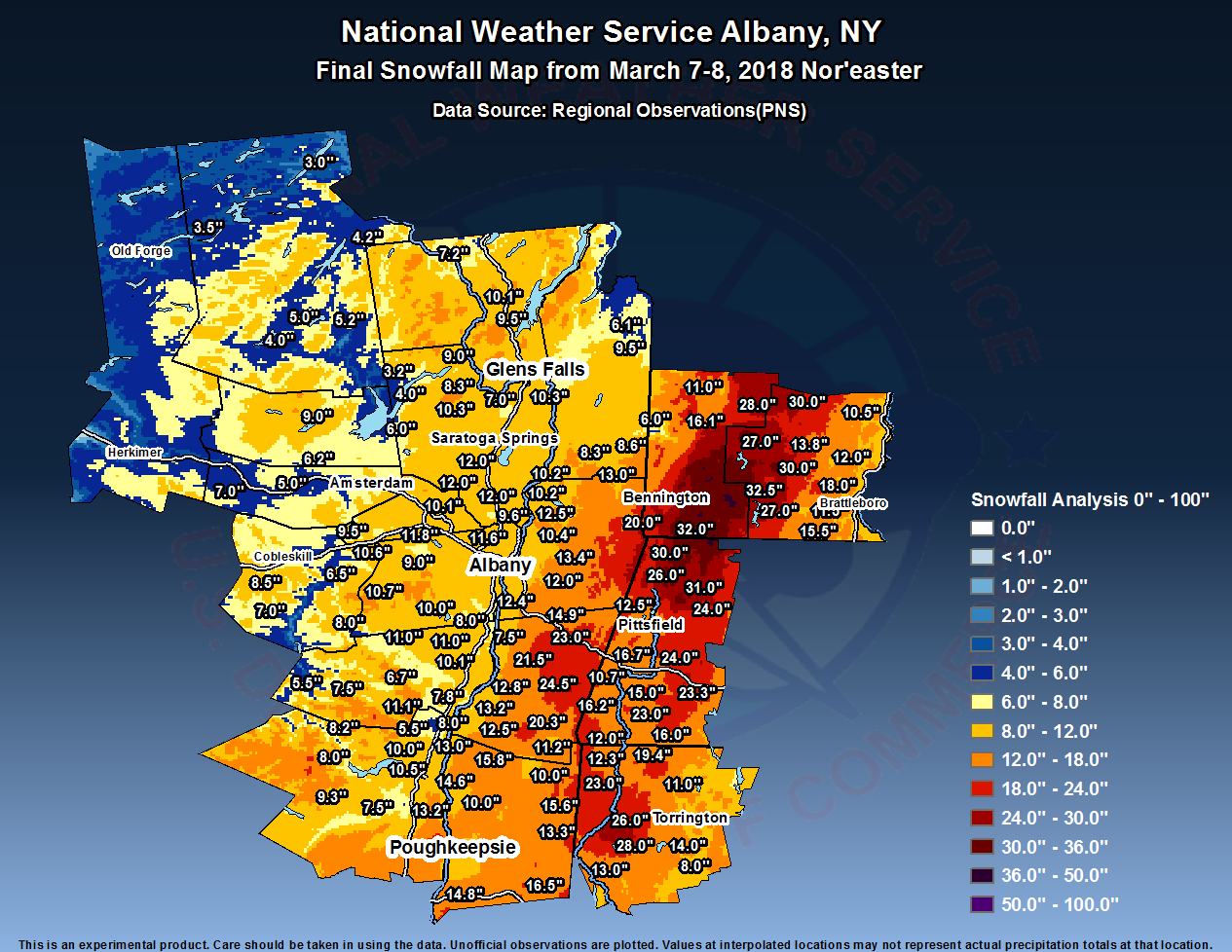
Public Information Statement...Corrected
Spotter Reports
National Weather Service Albany NY
303 PM EST Thu Mar 08 2018

The following are unofficial observations taken during the past 34
hours for the storm that has been affecting our region. Appreciation
is extended to highway departments, cooperative observers, Skywarn
spotters and media for these reports. This summary also is available
on our home page at weather.gov/albany

********************STORM TOTAL SNOWFALL********************

LOCATION          STORM TOTAL     TIME/DATE   COMMENTS
                     SNOWFALL           OF
                     /INCHES/   MEASUREMENT

CONNECTICUT

...Litchfield County...
   Warren                28.0   530 AM  3/08  Broadcast Media
   4 SSW Cornwall Bridg  26.0   700 AM  3/08  CoCoRaHS
   Sharon                23.0   530 AM  3/08  Broadcast Media
   Norfolk               19.4   800 AM  3/08  Co-Op Observer
   Litchfield            14.0   900 AM  3/08  Dept of Highways
   Roxbury               13.2   715 AM  3/08  Trained Spotter
   New Milford           13.0   643 AM  3/08  Trained Spotter
   1 SE New Milford      13.0   645 AM  3/08  Trained Spotter
   3 ESE New Milford     12.5   900 PM  3/07  Twitter
   5 NNW Winsted         12.5   700 AM  3/08  CoCoRaHS
   Canaan                12.3   900 AM  3/08  Dept of Highways
   Bakersville           12.3   700 AM  3/08  Co-Op Observer
   3 SW New Hartford     12.3   700 AM  3/08  CoCoRaHS
   Harwinton             12.0   400 AM  3/08  Trained Spotter
   Winsted               11.0   700 AM  3/08  Trained Spotter
   2 S Torrington         9.5   100 AM  3/08  Trained Spotter
   5 SSW New Milford      9.0   800 AM  3/08  CoCoRaHS
   3 WNW Winsted          8.5   900 AM  3/08  Dept of Highways
   1 WNW Oakville         8.0   718 AM  3/08  CoCoRaHS
   Barkhamsted            7.0   800 AM  3/08  Co-Op Observer

MASSACHUSETTS

...Berkshire County...
   Clarksburg            32.0   636 AM  3/08  WeatherNet6
   Cheshire              31.0  1018 AM  3/08  Social Media
   North Adams           30.0   804 AM  3/08  Amateur Radio
   Adams                 26.0   130 AM  3/08  Facebook
   Becket                24.0  1045 AM  3/08  Social Media
   Windsor               24.0   550 AM  3/08  Broadcast Media
   5 NW Otis             23.3   700 AM  3/08  CoCoRaHS
   3 NW Sandisfield      23.0   900 AM  3/08  Social Media
   Peru                  20.0   730 AM  3/08  Broadcast Media
   Pittsfield            17.5   722 AM  3/08  Trained Spotter
   Lenoxdale             16.7   600 AM  3/08  Trained Spotter
   Great Barrington      16.2   648 AM  3/08  Trained Spotter
   New Marlborough       16.0   422 AM  3/08  WeatherNet6
   1 SE Housatonic       15.0   700 AM  3/08  CoCoRaHS
   3 S Sandisfield       12.5   730 AM  3/08  Twitter
   1 NNW Pittsfield      12.5   800 AM  3/08  CoCoRaHS
   Ashley Falls          12.0   649 AM  3/08  Trained Spotter
   Lee                   11.0   636 AM  3/08  Utility Company
   3 NE Housatonic       10.7   600 AM  3/08  CoCoRaHS

NEW YORK

...Albany County...
   1 NE Shakers          11.6   700 AM  3/08  ASOS
   Delmar                10.8   625 AM  3/08  Trained Spotter
   2 W Albany            10.8   950 AM  3/08  Retired NWS Emp.
   Knox                  10.6   703 AM  3/08  WeatherNet6
   Colonie               10.5   554 AM  3/08  WeatherNet6
   1 W Albany            10.5   700 AM  3/08  CoCoRaHS
   4 WNW Ravena          10.0   700 AM  3/08  CoCoRaHS
   Watervliet            10.0   645 AM  3/08  Trained Spotter
   Boght Corners          9.6   628 AM  3/08  NWS Employee
   1 E North Bethlehem    9.2   840 AM  3/08  NWS Employee
   Albany                 9.1   400 AM  3/08  NWS Albany Office
   2 SSW Altamont         9.0   815 AM  3/08  CoCoRaHS
   1 WNW Albany           8.9   810 AM  3/08  NWS Employee
   Ravena                 8.5   348 AM  3/08  WeatherNet6
   Alcove Dam             8.0   730 AM  3/08  Co-Op Observer

...Columbia County...
   4 N Hillsdale         24.5   359 AM  3/08  Trained Spotter
   1 N Chatham           23.0   700 AM  3/08  Social Media
   Austerlitz            21.5   454 AM  3/08  WeatherNet6
   Taghkanic             20.3   639 AM  3/08  WeatherNet6
   1 WSW Livingston      13.2   700 AM  3/08  CoCoRaHS
   Hollowville           12.8   400 AM  3/08  Facebook
   Livingston            12.5   624 AM  3/08  WeatherNet6
   Ancramdale            11.2   425 AM  3/08  WeatherNet6
   Germantown             8.0   956 AM  3/08  WeatherNet6

...Dutchess County...
   Poughquag             16.5   820 AM  3/08  Public
   1 NE Red Hook         15.8   630 AM  3/08  CoCoRaHS
   Lagrange              15.8   650 AM  3/08  Trained Spotter
   Wassaic               15.6   700 AM  3/08  Trained Spotter
   6 ESE Pleasant Valle  15.0   700 AM  3/08  CoCoRaHS
   1 NE Fishkill         14.8   700 AM  3/08  CoCoRaHS
   Rhinebeck             14.6   700 AM  3/08  Meteorologist
   1 WSW Poughquag       14.5  1000 AM  3/08  Trained Spotter
   3 SE Millbrook        13.3   700 AM  3/08  CoCoRaHS
   3 WSW Elizaville      13.0   800 AM  3/08  Trained Spotter
   2 SSE Hopewell Junct  12.1   700 AM  3/08  CoCoRaHS
   1 SSE Poughkeepsie    11.0  1100 AM  3/08  Public
   Pine Plains           10.0   800 AM  3/08  Public
   3 SSE Rhinebeck       10.0   830 AM  3/08  Trained Spotter
   1 WSW Red Oaks Mill    8.4   500 AM  3/08  CoCoRaHS
   Red Oaks Mill          8.4   530 AM  3/08  Trained Spotter

...Fulton County...
   7 NW GLOVERSVILLE      9.0   700 AM  3/08  Co-Op Observer
   Broadalbin             6.0   632 AM  3/08  WeatherNet6
   Perth                  6.0  1004 PM  3/07  WeatherNet6
   Northville             3.2   623 AM  3/08  WeatherNet6

...Greene County...
   Platte Clove          11.1   715 AM  3/08  Co-Op Observer
   7 SSE Westerlo        11.0   500 AM  3/08  CoCoRaHS
   Greenville Center     11.0   324 AM  3/08  WeatherNet6
   4 NNE Cairo           10.1   532 AM  3/08  CoCoRaHS
   Catskill               7.8  1048 AM  3/08  WeatherNet6
   West Kill              7.5   407 AM  3/08  WeatherNet6
   2 SE Ravena            7.5   700 AM  3/08  CoCoRaHS
   East Jewett            6.7   700 AM  3/08  Co-Op Observer
   Halcott Center         5.5   232 AM  3/08  WeatherNet6

...Hamilton County...
   Wells                  5.2   612 AM  3/08  WeatherNet6
   3 ENE Piseco           5.0   700 AM  3/08  CoCoRaHS
   2 SW Indian Lake       4.2   815 AM  3/08  Co-Op Observer
   Piseco                 4.0   508 AM  3/08  WeatherNet6
   Inlet                  3.5   610 AM  3/08  Trained Spotter
   Long Lake              3.0   700 AM  3/08  CoCoRaHS

...Herkimer County...
   Ilion                  3.9   730 AM  3/08  CoCoRaHS

...Montgomery County...
   Amsterdam              8.5  1101 AM  3/08  WeatherNet6
   4 ENE East Springfie   7.0   900 AM  3/08  CoCoRaHS
   Hessville              7.0   844 AM  3/08  WeatherNet6
   Fonda                  6.2  1032 AM  3/08  WeatherNet6
   Palatine Bridge        5.0   432 AM  3/08  WeatherNet6

...Rensselaer County...
   Petersburg            20.0   506 AM  3/08  WeatherNet6
   4 ESE Nassau          14.9   800 AM  3/08  CoCoRaHS
   1 WNW Averill Park    13.4  1100 AM  3/08  Meteorologist
   Buskirk               13.0   730 AM  3/08  Trained Spotter
   Averill Park          12.9   800 AM  3/08  CoCoRaHS
   Speigletown           12.5  1052 AM  3/08  WeatherNet6
   East Schodack         12.4   600 AM  3/08  Facebook
   3 SSW West Sand Lake  12.0   630 AM  3/08  Trained Spotter
   5 E Waterford         12.0   700 AM  3/08  CoCoRaHS
   2 NE Troy             10.4   900 AM  3/08  CoCoRaHS
   1 N Sycaway           10.4   900 AM  3/08  NWS Employee
   2 NE Mechanicville    10.2   830 AM  3/08  Emergency Manager
   Troy                   8.7   700 AM  3/08  CoCoRaHS

...Saratoga County...
   1 WSW Round Lake      12.0   800 AM  3/08  CoCoRaHS
   1 NNW Jonesville      12.0   730 AM  3/08  NWS Employee
   2 ESE Ballston Spa    12.0   900 AM  3/08  CoCoRaHS
   2 S Clifton Park Cen  11.4   959 AM  3/08  Retired NWS Emp.
   Hickeys Corners       11.0  1100 AM  3/08  Retired NWS Emp.
   Malta                 10.4   706 AM  3/08  Trained Spotter
   Lake Desolation       10.3   438 AM  3/08  WeatherNet6
   1 W Gansevoort        10.3   630 AM  3/08  CoCoRaHS
   2 NNE Mechanicville   10.2   830 AM  3/08  Emergency Manager
   3 S Saratoga Lake      9.6   700 AM  3/08  CoCoRaHS
   Saratoga Springs       9.1   859 PM  3/07  WeatherNet6
   Conklingville Dam      9.0   800 AM  3/08  Co-Op Observer
   Wilton                 7.0   545 AM  3/08  Trained Spotter
   2 SE Clifton Park      6.7   605 AM  3/08  CoCoRaHS
   Edinburg               4.0  1030 AM  3/08  WeatherNet6

...Schenectady County...
   Rotterdam             11.8   800 AM  3/08  CoCoRaHS
   Schenectady-GE Plot   10.1   720 AM  3/08  NWS Employee
   1 NNW Niskayuna        9.9   730 AM  3/08  NWS Employee
   1 SSW Aqueduct         9.5   500 AM  3/08  NWS Employee
   Delanson               9.5   123 AM  3/08  WeatherNet6
   Niskayuna              9.0   700 AM  3/08  Co-Op Observer
   Schenectady            8.2  1001 AM  3/08  WeatherNet6
   1 NNE Hawthorne Hill   7.8   830 AM  3/08  NWS Employee
   Duanesburg             7.0   530 AM  3/08  WeatherNet6

...Schoharie County...
   Middleburgh           10.7   351 AM  3/08  WeatherNet6
   Richmondville          8.5   524 AM  3/08  WeatherNet6
   Gilboa                 8.0   951 PM  3/07  WeatherNet6
   Jefferson              7.0   718 PM  3/07  WeatherNet6
   Schoharie              6.5   920 PM  3/07  WeatherNet6
   Cobleskill             6.2   952 PM  3/07  Public
   Charlotteville         5.8   337 PM  3/07  WeatherNet6
   2 ESE Cobleskill       5.0   735 AM  3/08  Co-Op Observer

...Ulster County...
   Highland              21.0   230 AM  3/08  Facebook
   4 WNW Marlboro        15.0   640 AM  3/08  Social Media
   Wallkill              14.0   602 PM  3/07  Twitter
   3 S Port Ewen         13.2   730 AM  3/08  CoCoRaHS
   Lincoln Park          10.5   700 AM  3/08  CoCoRaHS
   Ulster Park           10.5   612 AM  3/08  WeatherNet6
   2 NW Lake Katrine     10.0   700 AM  3/08  CoCoRaHS
   West Hurley            9.3   700 AM  3/08  CoCoRaHS
   3 N Kerhonkson         9.3   700 AM  3/08  CoCoRaHS
   Phoenicia              8.2   600 AM  3/08  Co-Op Observer
   Kingston               8.0   426 AM  3/08  WeatherNet6
   West Shokan            8.0   243 AM  3/08  WeatherNet6
   1 NW Rosendale         7.5  1000 AM  3/08  Trained Spotter
   1 WNW Rosendale Vill   7.5   830 AM  3/08  CoCoRaHS
   1 WNW Rosendale        6.9   845 PM  3/07  Public
   2 E Rosendale          6.1   800 AM  3/08  Co-Op Observer
   Saugerties             5.5   552 AM  3/08  WeatherNet6

...Warren County...
   2 WNW Warrensburg     10.1   825 AM  3/08  CoCoRaHS
   Warrensburg            9.5   531 AM  3/08  WeatherNet6
   Glens Falls            9.0   730 AM  3/08  Meteorologist
   Lake Luzerne           8.3   600 AM  3/08  Co-Op Observer
   5 SE North Creek       7.2   700 AM  3/08  Co-Op Observer

...Washington County...
   Hartford               9.5   700 AM  3/08  Public
   Cambridge              8.6   750 AM  3/08  Trained Spotter
   1 SW Cambridge         8.3   830 AM  3/08  Trained Spotter
   Hudson Falls           7.5   600 AM  3/08  WeatherNet6
   4 NE Hartford          6.1   900 AM  3/08  Emergency Manager

VERMONT

...Bennington County...
   Woodford              36.0   607 AM  3/08  WeatherNet6
   4 E Woodford State P  35.0   639 AM  3/08  Utility Company
   Searsburg             32.5   420 AM  3/08  Dept of Highways
   Peru                  28.0   730 AM  3/08  Facebook
   Landgrove             26.5  1030 AM  3/08  WeatherNet6
   1 WNW Weston          25.0   700 AM  3/08  CoCoRaHS
   1 E Manchester Cente  16.1   700 AM  3/08  CoCoRaHS
   East Dorset           11.0   750 AM  3/08  Facebook
   West Arlington         6.0   503 AM  3/08  WeatherNet6

...Windham County...
   Londonderry           30.0   800 AM  3/08  Facebook
   2 NNE West  Dover     30.0  1115 AM  3/08  Public
   1 WNW Wilmington      27.0   622 AM  3/08  CoCoRaHS
   West Wardsboro        27.0   940 AM  3/08  Facebook
   1 ESE West Wardsboro  26.4   839 AM  3/08  CoCoRaHS
   Wilmington            25.0   627 AM  3/08  Utility Company
   West  Dover           21.0   200 AM  3/08  Facebook
   Windham               20.0   300 AM  3/08  Facebook
   4 SW Newfane          18.0   820 AM  3/08  Public
   2 ESE Jacksonville    15.5   740 AM  3/08  CoCoRaHS
   Townshend             13.8   830 AM  3/08  Trained Spotter
   Putney                12.0  1115 AM  3/08  Public
   Newfane               12.0   715 AM  3/08  Facebook
   3 W Westminster       11.5   900 AM  3/08  CoCoRaHS
   4 W Westminster       11.5  1030 AM  3/08  Trained Spotter
   Brattleboro           11.5   820 AM  3/08  Public
   3 WSW Charlestown     10.5   600 AM  3/08  CoCoRaHS
   Marlboro              10.4   700 AM  3/08  Co-Op Observer
   2 NNW Putney           9.0   700 AM  3/08  CoCoRaHS

&&
Radar:
KENX radar loop from 12:45 am March 7 through 8:00 am March 8
 |
 |
Media use of NWS Web News Stories is encouraged! Please acknowledge the NWS as the source of any news information accessed from this site. |
|

