Overview
July 2023 was exceptionally wet across most of eastern New York and western New England. Monthly rainfall totals generally ranged between 6 and 12 inches with some areas receiving slightly more while others received less. The highest values generally occurred across areas along and west of the Hudson Valley. Several rounds of showers and thunderstorms occurred during the month leading to numerous instances of both severe weather and flooding.
A recap of some of the monthly weather events are displayed below:
July 4:
July 9-11:
Across southern Vermont, rainfall totals generally ranged between 2.50 and 5.00 inches with some localized amounts of around 6 inches across the southern Green Mountains. This rainfall resulted in areas of areal and flash flooding. The hardest hit area was in the Town of Londonderry as water flooded numerous roads and caused portions of the area to be inaccessible. Many other roadways across southern Vermont were closed due to flooding from the combination of heavy rainfall and rivers overflowing their banks. A few water rescues were also conducted to assist those in rising flood waters. Vermont Governor Phil Scott declared a state of emergency on July 10 as a result of the flooding. President Joe Biden later approved a major disaster declaration for the state of Vermont.
Across western Massachusetts, rainfall totals were generally in the 1.50 to 4.00 inch range. Areas receiving flooding included the City of North Adams and the towns of Clarksburg, Becket, Sheffield, Washington and Great Barrington mainly consisting of closed and/or washed out roads and flooded homes/basements. Damage within the City of North Adams was estimated at $1.5 million. A State of Emergency was issued for North Adams, Becket, Hinsdale and Clarksburg due to the flooding.
Across northwestern Connecticut, rainfall amounts between 4 and 7 inches occurred. This resulted in numerous reports of flash flooding and washed out roads and culverts. A local declaration of emergency was issued in the Town of Norfolk following flash flood damage along Route 272. The damage along this road caused some homes to become isolated. A State of Emergency was also issued by Goshen First Selectman Todd Carusillo.
July 13-15:
Climate Stats:
July 4, 2023 Severe Weather
Thunderstorm Wind
|
Straight Line Wind - near Stuyvesant, NY
Track Map 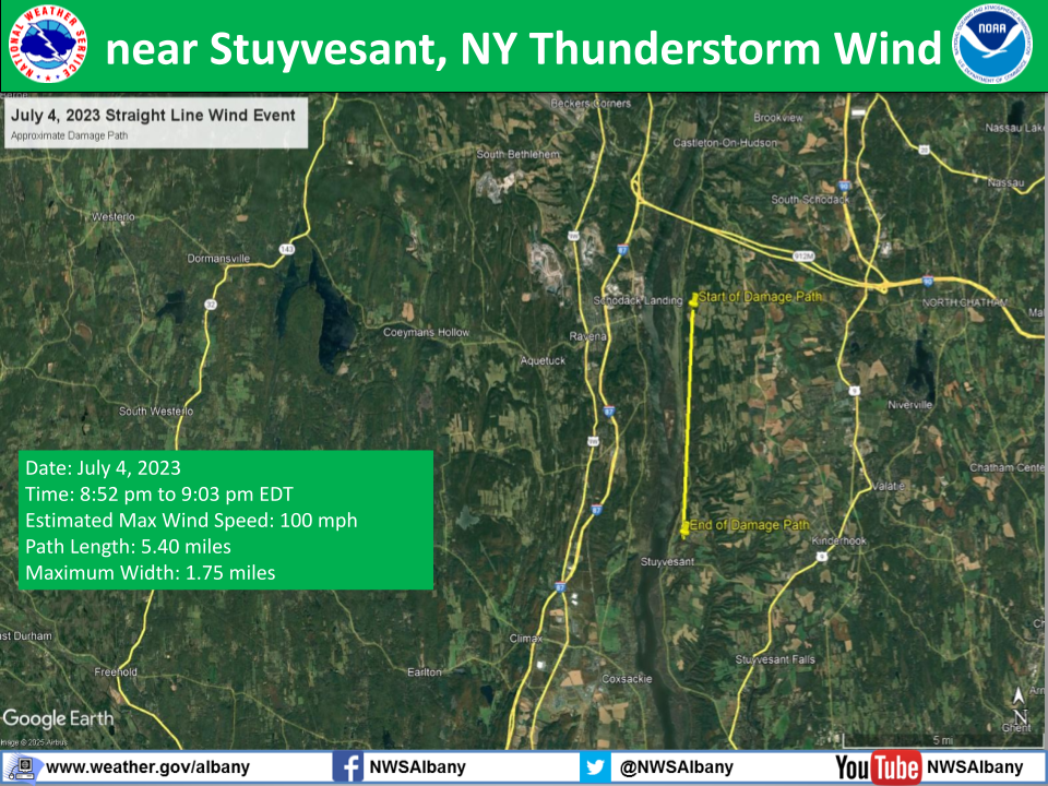 |
||||||||||||||
Radar
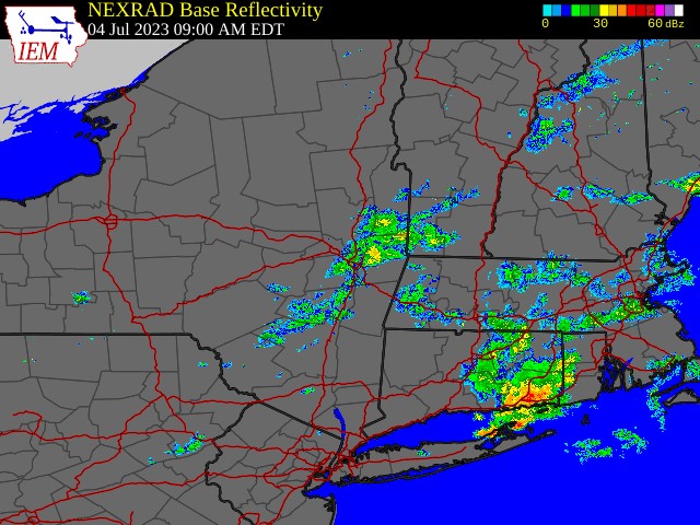 |
| Regional Radar Loop valid 9:00 am July 4 to 12:00 am July 5, 2023 |
Storm Reports
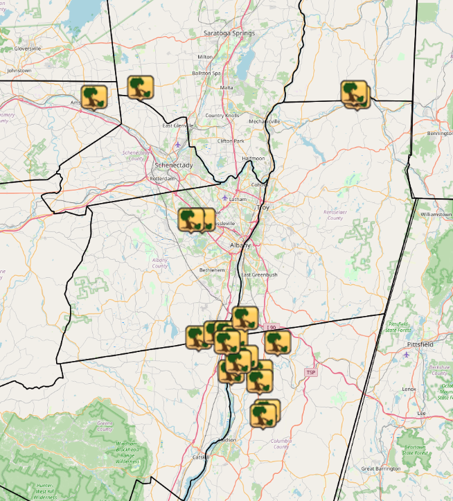

Preliminary storm reports across the NWS Albany County Warning Area from July 4, 2023 (Map above courtesy of Iowa Environmental Mesonet).
Preliminary Local Storm Report...Summary
National Weather Service Albany NY

..TIME...   ...EVENT...      ...CITY LOCATION...     ...LAT.LON...
..DATE...   ....MAG....      ..COUNTY LOCATION..ST.. ...SOURCE....
            ..REMARKS..

0714 PM     Tstm Wnd Dmg     Buskirk                 42.96N  73.44W
07/04/2023                   Washington         NY   Trained Spotter

            Downed trees and wires on King Road and Route 67

0718 PM     Tstm Wnd Dmg     Buskirk                 42.95N  73.43W
07/04/2023                   Rensselaer         NY   Social Media

            100 foot pine tree down on a house on Route 67 moving
            eastbound just passed Buskirk Seventh-day Adventist
            Church

0725 PM     Tstm Wnd Dmg     1 N West Charlton       42.97N  74.03W
07/04/2023                   Saratoga           NY   Social Media

            Multiple trees downed on Route 147 between Galway and
            Glenville
0748 PM     Tstm Wnd Dmg     1 SE Rockton            42.95N  74.16W
07/04/2023                   Montgomery         NY   Trained Spotter

            Large branches down near the corner of Regina Lane and
            Bylina Lane in the City of Amsterdam
0812 PM     Tstm Wnd Dmg     1 NE Westmere           42.70N  73.86W
07/04/2023                   Albany             NY   911 Call Center

            Wires donw on a shed on 5 Velina Drive in Guilderland

0840 PM     Tstm Wnd Dmg     1 SSW Rivers Mobile Hom 42.50N  73.74W
07/04/2023                   Rensselaer         NY   Dept of Highways

            Route 9J and Knickerbocker Road closed due to multiple
            downed trees.

0840 PM     Tstm Wnd Dmg     2 W Aquetuck            42.46N  73.87W
07/04/2023                   Albany             NY   911 Call Center

            Tree and wires downed on Biechman Road

0840 PM     Tstm Wnd Dmg     Coeymans                42.47N  73.80W
07/04/2023                   Albany             NY   911 Call Center

            Multiple trees down on Main Street

0842 PM     Tstm Wnd Dmg     1 SSW Ravena            42.47N  73.82W
07/04/2023                   Albany             NY   911 Call Center

            Tree leaning on wires in Oakbrook Manor on Route 9W

0845 PM     Tstm Wnd Dmg     New Baltimore           42.45N  73.79W
07/04/2023                   Greene             NY   Dept of Highways

            Route 144 closed on the Albany/Greene County line due
            to multiple downed trees.

0855 PM     Tstm Wnd Dmg     2 SW Hanson Trailer Par 42.42N  73.74W
07/04/2023                   Columbia           NY   911 Call Center

            Trees downed on Eichybush Road

0856 PM     Tstm Wnd Dmg     Niverville              42.45N  73.65W
07/04/2023                   Columbia           NY   Amateur Radio

            Multiple trees and wires down on roadways

0856 PM     Tstm Wnd Dmg     Stuyvesant              42.39N  73.78W
07/04/2023                   Columbia           NY   Amateur Radio

            Tree down at 1094 Route 9J

0856 PM     Tstm Wnd Dmg     1 NE New Baltimore      42.46N  73.77W
07/04/2023                   Columbia           NY   911 Call Center

            Trees downed at the intesection of Ridge Road and State
            Route 9J. State Route 9J closed due to downed trees from
            the Rensselaer County border down to State Route 9 in
            Stockport.

0857 PM     Tstm Wnd Dmg     2 SSE Poolsburg         42.41N  73.76W
07/04/2023                   Columbia           NY   911 Call Center

            Trees downed on Hollow Road

0902 PM     Tstm Wnd Dmg     Kinderhook              42.39N  73.70W
07/04/2023                   Columbia           NY   Amateur Radio

            Multiple trees down in Kinderhook

0905 PM     Tstm Wnd Dmg     2 ENE Stuyvesant Falls  42.37N  73.70W
07/04/2023                   Columbia           NY   Social Media

            Tree limbs downed on Route 9H

0914 PM     Tstm Wnd Dmg     1 S Omi                 42.31N  73.68W
07/04/2023                   Columbia           NY   911 Call Center

            Trees downed on George Road in the town of Ghent

0924 PM     Tstm Wnd Dmg     1 SSE West Ghent        42.30N  73.69W
07/04/2023                   Columbia           NY   Amateur Radio

            Wires down on Orchard Road
July 9-11, 2023 Severe Weather and Flooding
Radar
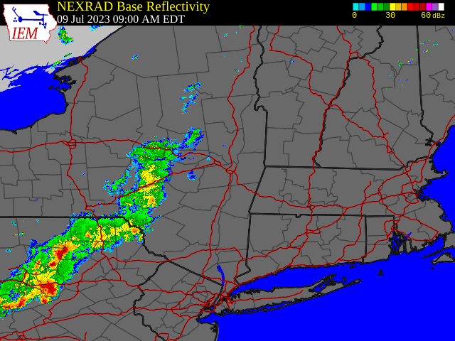 |
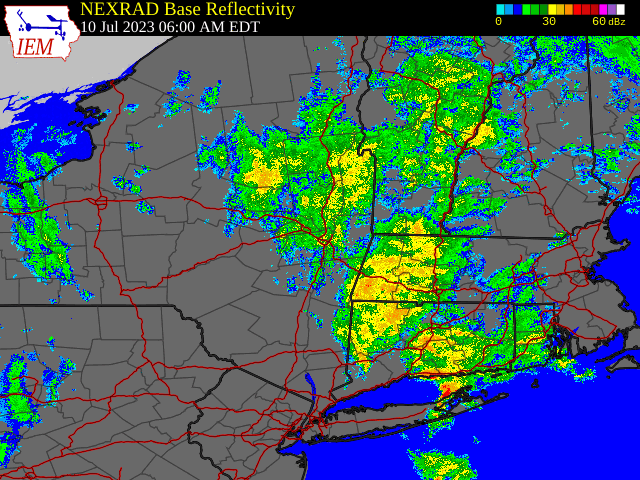 |
| Regional Radar Loop valid 9:00 am July 9 to 6:00 am July 10, 2023 | Regional Radar Loop valid 6:00 am July 10 to 6:00 am July 11, 2023 |
Storm Reports
Preliminary storm reports across the NWS Albany County Warning Area from July 9-11, 2023 (Map above courtesy of Iowa Environmental Mesonet).
Preliminary Local Storm Report...Summary
National Weather Service Albany NY

..TIME...   ...EVENT...      ...CITY LOCATION...     ...LAT.LON...
..DATE...   ....MAG....      ..COUNTY LOCATION..ST.. ...SOURCE....
            ..REMARKS..

0218 PM     Flood            3 ENE Accord            41.80N  74.18W
07/09/2023                   Ulster             NY   Fire Dept/Rescue

            Creek Road flooded near Accord in the Town of Rochester

0218 PM     Flash Flood      3 WNW Winchester Center 41.92N  73.19W
07/09/2023                   Litchfield         CT   Broadcast Media

            Several portions of Route 272 and surrounding roads
            were washed out between Bruey Road and Route 263. Time
            estimated by radar.

0230 PM     Flash Flood      1 N Nelsons Corner      41.96N  73.05W
07/09/2023                   Litchfield         CT   Broadcast Media

            Only one lane passable on Colebrook River Rd near
            Winstead.

0240 PM     Flash Flood      1 ENE Kyserike          41.81N  74.15W
07/09/2023                   Ulster             NY   Law Enforcement

            Multiple road closures along the Rondout Creek near
            Marbletown.

0252 PM     Flood            1 WSW Plattekill        41.61N  74.10W
07/09/2023                   Ulster             NY   Fire Dept/Rescue

            Flooding along portions of Quaker Street near
            Plattekill.

0253 PM     Tstm Wnd Dmg     1 NNE Eagle Bridge      42.95N  73.40W
07/09/2023                   Rensselaer         NY   911 Call Center

            Tree down blockig road on RT 67 and Eagle Bridge Road
            in Hoosick, NY

0255 PM     Flash Flood      South Norfolk           41.93N  73.21W
07/09/2023                   Litchfield         CT   Broadcast Media

            Rt 272 flooded near Estey Rd. Photo posted to social
            media.

0301 PM     Flash Flood      South Norfolk           41.93N  73.21W
07/09/2023                   Litchfield         CT   Law Enforcement

            Route 272 washed out near the intersection with Goshen
            St E. Time estimated from radar.

0305 PM     Tstm Wnd Dmg     Eagle Bridge            42.95N  73.40W
07/09/2023                   Rensselaer         NY   911 Call Center

            Tree down on house.

0310 PM     Flash Flood      Cornwall                41.84N  73.33W
07/09/2023                   Litchfield         CT   Emergency Mngr

            Culvert running under train tracks washed out by flash
            flooding. Time estimated from radar.

0318 PM     Tstm Wnd Dmg     1 SE Albany             42.66N  73.77W
07/09/2023                   Albany             NY   Trained Spotter

            Meteorololgist reports multiple trees and wires down
            across Albany, including on N Lake Ave and 3rd Ave.

0325 PM     Tstm Wnd Dmg     Guilderland             42.70N  73.89W
07/09/2023                   Albany             NY   Public

            Public reports trees and wires down in Guilderland.
            Time esimated from radar.

0325 PM     Tstm Wnd Dmg     Westmere                42.69N  73.87W
07/09/2023                   Albany             NY   NWS Employee

            Large tree and wires down on Johnston Rd between
            Western Ave and Church Rd. Time estimated from radar.

0335 PM     Tstm Wnd Dmg     1 SE Albany             42.65N  73.77W
07/09/2023                   Albany             NY   Trained Spotter

            A few small trees and tree limbs reported down near
            Washington Park and the intersection of Madison Ave and
            New Scotland Ave.

0340 PM     Tstm Wnd Dmg     Schaghticoke Hill       42.88N  73.60W
07/09/2023                   Rensselaer         NY   Trained Spotter

            Many branches and a few trees reported down along Rt 40
            south of Schaghticoke. Time estimated from radar.

0345 PM     Flood            Lagrangeville           41.65N  73.76W
07/09/2023                   Dutchess           NY   Law Enforcement

            Street flooding along Route 82 near East Noxon Road in
            Lagrangeville

0345 PM     Lightning        Mechanicville           42.90N  73.69W
07/09/2023                   Saratoga           NY   Trained Spotter

            Lightning struck a propane tank and caused an
            automotive body shop to catch fire.

0350 PM     Tstm Wnd Dmg     Willow Glen             42.92N  73.72W
07/09/2023                   Saratoga           NY   Trained Spotter

            Power lines and poles reported down near Rt 67 and
            George Thompson Rd. Time estimated from radar.

0405 PM     Flood            Mechanicville           42.90N  73.69W
07/09/2023                   Saratoga           NY   Trained Spotter

            S Central Ave flooded beneath railroad viaduct in
            Mechanicville.

0408 PM     Flash Flood      2 SSW Reynolds          42.86N  73.68W
07/09/2023                   Saratoga           NY   Trained Spotter

            Various portions of Rt 4 and Rt 32 flooded between
            Mechanicville and Waterford. Portion of Lower Newtown Rd
            washed out.

0430 PM     Flash Flood      Melrose                 42.85N  73.62W
07/09/2023                   Rensselaer         NY   Dept of Highways

            Rt 40 between Pinewoods Rd and Doty Ave closed in both
            directions due to flooding.
0442 PM     Flash Flood      1 ESE Pine Grove Terrac 41.62N  73.66W
07/09/2023                   Dutchess           NY   Social Media

            Water and debris over Pleasant Ridge Rd
0524 PM     Flash Flood      2 S Beacon              41.48N  73.97W
07/09/2023                   Dutchess           NY   Law Enforcement

            Route 9D closed near Slocum Road in the City of Beacon
            due to flooding.

0250 AM     Flood            Jamaica                 43.10N  72.78W
07/10/2023                   Windham            VT   Dept of Highways

            VT-30 in Jamaica near West Hill Road South is closed
            due to flooding.

0357 AM     Flood            Winhall                 43.16N  72.92W
07/10/2023                   Bennington         VT   Dept of Highways

            VT 30 in Winhall near Stoney Hill Road is closed due to
            flooding.

0432 AM     Flash Flood      2 WSW Sylvan Lake       41.60N  73.76W
07/10/2023                   Dutchess           NY   Law Enforcement

            The Taconic State Parkway flooded at the Beekman Road
            Ramp at approximately 4:32AM and was cleared at
            approximately 10AM

0520 AM     Flood            1 NNW Green Island      42.76N  73.70W
07/10/2023                   Albany             NY   Dept of Highways

            Route 32 northbound and southbound lanes closed between
            Tibbits Ave and Bridge Ave.

0612 AM     Flash Flood      1 NNW Dover Plains      41.76N  73.58W
07/10/2023                   Dutchess           NY   Newspaper

            State Route 343 closed in both directions at Old Route
            22

0615 AM     Flash Flood      Kent                    41.72N  73.48W
07/10/2023                   Litchfield         CT   Emergency Mngr

            2 houses evacuated on Preston Hollow Rd due to rising
            flood waters. Numerous additional reports of basement
            flooding and road closures in the town of Kent.

0628 AM     Flash Flood      1 NNE Arthursburg       41.64N  73.76W
07/10/2023                   Dutchess           NY   Law Enforcement

            Emans Road at State Route 82 was flooded at
            approaximately 6:28 AM and was cleared at approxmately
            11:55 AM

0909 AM     Flash Flood      Peru                    43.23N  72.90W
07/10/2023                   Bennington         VT   Dept of Highways

            Vermont Route 11 closed from US 7 in Manchester to VT
            100 in Londonderry due to flooding

0910 AM     Flash Flood      Londonderry             43.23N  72.81W
07/10/2023                   Windham            VT   Emergency Mngr

            Numerous road closures due to flooding have isolated
            parts of the Londonderry area.

1045 AM     Flash Flood      3 S Brookline           42.99N  72.60W
07/10/2023                   Windham            VT   Trained Spotter

            Trained spotter reports Putney Mountain Rd is closed
            due to a washout.

0320 PM     Flood            Wilmington              42.87N  72.87W
07/10/2023                   Windham            VT   Social Media

            VT Rte 9 through Wilmington Village is shut down due to
            flooding.
0530 PM     Flood            1 NW Bartonsville       43.24N  72.55W
07/10/2023                   Windham            VT   Dept of Highways

            Vermont Route 103 closed from Rounds Road in the Town
            of Chester to Lower Bartonsville Road in the Town of
            Rockingham.
0210 AM     Flood            2 SSE Deerland          43.91N  74.44W
07/11/2023                   Hamilton           NY   Dept of Highways

            Route 28N between Blue Mountain Lake and Long Lake
            closed due to flooding and debris.


0255 AM     Flood            2 WNW Long Lake         43.98N  74.45W
07/11/2023                   Hamilton           NY   Dept of Highways

            Route 30 closed from the Franklin County line to Long
            Lake.
0620 AM     Flood            Westminster             43.08N  72.46W
07/11/2023                   Windham            VT   Dept of Highways

            US-5 in Westminster from VT-123 to Potter Industrial
            Drive is closed due to flooding
July 13-15, 2023 Severe Weather
Radar
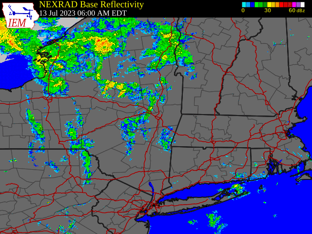 |
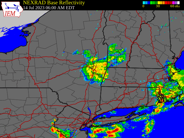 |
| Regional Radar Loop valid 6:00 am July 13 to 6:00 am July 14, 2023 | Regional Radar Loop valid 6:00 am July 14 to 6:00 am July 15, 2023 |
Storm Reports
Preliminary storm reports across the NWS Albany County Warning Area from July 13-15, 2023 (Map above courtesy of Iowa Environmental Mesonet).
Preliminary Local Storm Report...Summary
National Weather Service Albany NY

..TIME...   ...EVENT...      ...CITY LOCATION...     ...LAT.LON...
..DATE...   ....MAG....      ..COUNTY LOCATION..ST.. ...SOURCE....
            ..REMARKS..

0340 PM     Hail             1 NE Brant Lake         43.69N  73.74W
07/13/2023  M1.00 inch       Warren             NY   Social Media

0340 PM     Hail             2 ENE Brant Lake        43.68N  73.72W
07/13/2023  M1.25 inch       Warren             NY   Trained Spotter
0353 PM     Tstm Wnd Dmg     Brandreth               43.94N  74.85W
07/13/2023                   Herkimer           NY   Amateur Radio

            Significant blowdown in the area from winds associated
            with line of thunderstorms.
0355 PM     Tstm Wnd Dmg     Partlow                 43.97N  74.83W
07/13/2023                   Hamilton           NY   Amateur Radio

            Significant blowdown in the area from winds associated
            with line of thunderstorms.
0355 PM     Tstm Wnd Dmg     Keepawa                 43.96N  74.84W
07/13/2023                   Herkimer           NY   Amateur Radio

            Significant blowdown in the area from winds associated
            with line of thunderstorms.

0400 PM     Tstm Wnd Dmg     3 SW Ohio               43.29N  75.01W
07/13/2023                   Herkimer           NY   911 Call Center

            Numerous trees and wires down in both the Towns of
            Russia and Ohio.
0425 PM     Tstm Wnd Dmg     Gulph                   43.01N  75.16W
07/13/2023                   Herkimer           NY   911 Call Center

            One Tree Down

0440 PM     Hail             West Winfield           42.88N  75.19W
07/13/2023  M1.00 inch       Herkimer           NY   Trained Spotter

            Small branches down
0441 PM     Tstm Wnd Dmg     Salisbury               43.13N  74.83W
07/13/2023                   Herkimer           NY   911 Call Center

            Tree down blocking road.

0442 PM     Tstm Wnd Dmg     Salisbury               43.13N  74.82W
07/13/2023                   Herkimer           NY   911 Call Center

            One Tree Down

0505 PM     Tstm Wnd Dmg     East Creek              43.01N  74.75W
07/13/2023                   Herkimer           NY   911 Call Center

            Tree blocking west bound lane of Route 5.

0523 PM     Tstm Wnd Dmg     Ephratah                43.00N  74.54W
07/13/2023                   Fulton             NY   911 Call Center

            Multiple trees and wires down across southern and
            eastern Fulton County per 911 dispatch

0523 PM     Tstm Wnd Dmg     Ephratah                43.00N  74.54W
07/13/2023                   Fulton             NY   911 Call Center

            Multiple trees and wires down across southern and
            eastern Fulton County per 911 dispatch

0530 PM     Tstm Wnd Dmg     1 NNW North Bolton      43.61N  73.66W
07/13/2023                   Warren             NY   Emergency Mngr

            Several trees and powerlines down
0552 PM     Tstm Wnd Dmg     1 NE Fourth Lake        43.37N  73.81W
07/13/2023                   Warren             NY   911 Call Center

            Wires down blocking State Route 9N.

0600 PM     Tstm Wnd Dmg     Putnam                  43.75N  73.40W
07/13/2023                   Washington         NY   911 Call Center

            Tree downed across County Route 2

0602 PM     Tstm Wnd Dmg     1 WSW South Greenfield  43.09N  73.88W
07/13/2023                   Saratoga           NY   Fire Dept/Rescue

            Tree and wires down

0602 PM     Tstm Wnd Dmg     Crosbyside              43.42N  73.70W
07/13/2023                   Warren             NY   911 Call Center

            Tree on wires with transformer on fire.

0604 PM     Tstm Wnd Dmg     Queensbury              43.35N  73.68W
07/13/2023                   Warren             NY   Social Media

            Many trees and powerlines across the city. Streets are
            impassable in places.

0605 PM     Tstm Wnd Dmg     Sloansville             42.76N  74.33W
07/13/2023                   Schoharie          NY   Law Enforcement

            Trees and Wires Down on Route 20 and 30A.

0610 PM     Tstm Wnd Dmg     Kinderhook              42.40N  73.70W
07/13/2023                   Columbia           NY   Trained Spotter

            Tree and wires across Route 9 at Hudson St.

0610 PM     Tstm Wnd Dmg     Glens Falls             43.31N  73.64W
07/13/2023                   Warren             NY   911 Call Center

            Tree down blocking Walnut St.
0613 PM     Tstm Wnd Dmg     Harmony Corners         42.97N  73.95W
07/13/2023                   Saratoga           NY   Fire Dept/Rescue

            Tree and wires down

0613 PM     Tstm Wnd Dmg     Greenfield              43.10N  73.86W
07/13/2023                   Saratoga           NY   Social Media

            Multiple trees and wires down across Greenfield

0613 PM     Tstm Wnd Dmg     2 SE Huletts Landing    43.62N  73.49W
07/13/2023                   Washington         NY   911 Call Center

            Tree downed across Pike Brook Road

0615 PM     Tstm Wnd Dmg     Esperance               42.76N  74.25W
07/13/2023                   Schoharie          NY   Law Enforcement

            Trees down on Creek Side Road.

0615 PM     Tstm Wnd Dmg     Esperance               42.76N  74.26W
07/13/2023                   Schoharie          NY   Law Enforcement

            Wires Down on Charleston St.

0617 PM     Tstm Wnd Dmg     Overlook                43.29N  73.95W
07/13/2023                   Saratoga           NY   Fire Dept/Rescue

            Tree and wires down

0618 PM     Tstm Wnd Dmg     1 WSW Bacon Hill        43.13N  73.63W
07/13/2023                   Saratoga           NY   Fire Dept/Rescue

            Tree and wires down at Route 32 and Callahan Rd

0618 PM     Tstm Wnd Dmg     Sloansville             42.76N  74.33W
07/13/2023                   Schoharie          NY   Social Media

            Tree downed on Route 20

0620 PM     Non-Tstm Wnd Gst Wilton                  43.18N  73.74W
07/13/2023  M50 mph          Saratoga           NY   Trained Spotter

            Measured 50 mph thunderstorm wind gust

0622 PM     Tstm Wnd Dmg     Pattens Mills           43.38N  73.60W
07/13/2023                   Washington         NY   911 Call Center

            Multiple trees downed across Pattens Mills Road

0636 PM     Tstm Wnd Dmg     Whitehall               43.56N  73.42W
07/13/2023                   Washington         NY   911 Call Center

            Multiple trees and wires down across the county. 911
            dispatch too busy to talk

0638 PM     Tstm Wnd Dmg     1 WNW South Glens Falls 43.30N  73.65W
07/13/2023                   Warren             NY   Trained Spotter

            Porch damage on a house on Franklin st

0644 PM     Tstm Wnd Dmg     Fort Edward             43.27N  73.58W
07/13/2023                   Washington         NY   911 Call Center

            Tree downed across Hunt Ave

0650 PM     Tstm Wnd Gst     1 SE Paulies Mobile Hom 42.29N  73.71W
07/13/2023  M60 mph          Columbia           NY   AWOS

            60 mph wind gust measured at Columbia County airport.
            Multiple 2 inch tree limbs down

0655 PM     Tstm Wnd Dmg     Ghent                   42.33N  73.61W
07/13/2023                   Columbia           NY   Amateur Radio

            Multiple Trees and Wires Down on Route 9.

0655 PM     Tstm Wnd Dmg     Whitehall               43.56N  73.42W
07/13/2023                   Washington         NY   911 Call Center

            Tree downed across State Route 4

0715 PM     Tstm Wnd Dmg     Greenwich               43.09N  73.50W
07/13/2023                   Washington         NY   911 Call Center

            Trees and wires downed across County Route 49
0718 PM     Tstm Wnd Dmg     1 N Loudon Heights      42.70N  73.75W
07/13/2023                   Albany             NY   NWS Employee

            A tree and large limbs down along US Route 9 in
            Loudonville. Time estimated by radar.

0722 PM     Tstm Wnd Dmg     1 E Battenville         43.11N  73.41W
07/13/2023                   Washington         NY   911 Call Center

            Tree, pole and wires downed across County Route 61

0724 PM     Tstm Wnd Dmg     1 NW Catskill           42.22N  73.87W
07/13/2023                   Greene             NY   Dept of Highways

            Route 9W closed at Division Stdue to downed trees

0725 PM     Tstm Wnd Dmg     1 WSW Lenox             42.36N  73.30W
07/13/2023                   Berkshire          MA   Amateur Radio

            Tree Down on West St. near Tanglewood.

0725 PM     Tstm Wnd Dmg     1 WNW New Lenox         42.40N  73.25W
07/13/2023                   Berkshire          MA   Amateur Radio

            Tree and Wires Down.

0727 PM     Tstm Wnd Dmg     Germantown              42.13N  73.89W
07/13/2023                   Columbia           NY   911 Call Center

            Trees down across Route 9G

0732 PM     Tstm Wnd Dmg     1 ENE Viewmonte         42.11N  73.86W
07/13/2023                   Columbia           NY   911 Call Center

            Tree down on house

0738 PM     Tstm Wnd Dmg     Stockbridge             42.29N  73.32W
07/13/2023                   Berkshire          MA   Amateur Radio

            Tree and wires down on Hawthorne Rd
0740 PM     Tstm Wnd Dmg     1 NE Peru               43.24N  72.88W
07/13/2023                   Bennington         VT   Public

            Numerous trees down near the intersection of Route 11
            and Lovers Lane

0742 PM     Tstm Wnd Dmg     Richmond                42.37N  73.37W
07/13/2023                   Berkshire          MA   Amateur Radio

            Tree down on Baker St blocking roadway

0743 PM     Tstm Wnd Dmg     Claverack               42.22N  73.72W
07/13/2023                   Columbia           NY   911 Call Center

            *** 1 INJ *** Tree down on occupied vehicle. 1 minor
            injury

0745 PM     Hail             Germantown              42.13N  73.89W
07/13/2023  M1.00 inch       Columbia           NY   Trained Spotter
0749 PM     Flash Flood      Stockport               42.31N  73.75W
07/13/2023                   Columbia           NY   County Official

            Flooding of State Route 9 near County Route 22 in
            Stockport

0753 PM     Tstm Wnd Dmg     Pittsfield              42.45N  73.26W
07/13/2023                   Berkshire          MA   Amateur Radio

            Trees down in and around Pittsfield, MA

0753 PM     Tstm Wnd Dmg     Ghent                   42.33N  73.62W
07/13/2023                   Columbia           NY   911 Call Center

            Numerous trees down in Town of Ghent per law
            enforement.

0757 PM     Tstm Wnd Dmg     Chatham                 42.36N  73.60W
07/13/2023                   Columbia           NY   911 Call Center

            Trees down at multiple locations in Chatham per 911
            dispatch

0757 PM     Tstm Wnd Dmg     1 S Craryville          42.16N  73.58W
07/13/2023                   Columbia           NY   911 Call Center

            Trees down

0759 PM     Tstm Wnd Dmg     2 NNE Craryville        42.19N  73.57W
07/13/2023                   Columbia           NY   911 Call Center

            Trees down

0759 PM     Tstm Wnd Dmg     Phoenicia               42.09N  74.32W
07/13/2023                   Ulster             NY   Fire Dept/Rescue

            Trees downed across Forest Prserve Road

0800 PM     Tstm Wnd Dmg     1 NNE Tivoli            42.08N  73.90W
07/13/2023                   Columbia           NY   Dept of Highways

            Road closure due to downed tree on North and South
            NY-9G at Old Road in the Town of Clermont in Columbia
            County

0805 PM     Flash Flood      Pittsfield              42.45N  73.25W
07/13/2023                   Berkshire          MA   Amateur Radio

            Bradford Street, Center Street and Union Street all
            closed due to flooding

0822 PM     Tstm Wnd Dmg     Pownal                  42.77N  73.24W
07/13/2023                   Bennington         VT   Dept of Highways

            Tree down with power lines along VT 346 south of Church
            Street in Pownal. Time estimated by radar.

0827 PM     Tstm Wnd Dmg     Viewmonte               42.10N  73.87W
07/13/2023                   Columbia           NY   911 Call Center

            Tree down

0855 PM     Tstm Wnd Dmg     1 SW Fraleighs          41.99N  73.85W
07/13/2023                   Dutchess           NY   Dept of Highways

            Trees downed at the intersection of State Route 199 and
            Orlich Road. NY Route 199 was closed to traffic.

0916 PM     Tstm Wnd Dmg     Tyringham               42.25N  73.21W
07/13/2023                   Berkshire          MA   Amateur Radio

            Trees downed on Webster Road
0518 PM     Tstm Wnd Dmg     2 W Fort Plain          42.93N  74.67W
07/14/2023                   Montgomery         NY   911 Call Center

            Trees down along State Highway 80 near Fort Plain. Time
            estimated by radar.
0524 PM     Hail             1 SSE Mindenville       42.98N  74.71W
07/14/2023  M1.00 inch       Montgomery         NY   Social Media
0527 PM     Tstm Wnd Dmg     Mindenville             42.99N  74.72W
07/14/2023                   Montgomery         NY   911 Call Center

            Trees down. Time estimated by radar.
0618 PM     Flood            2 NW Delanson           42.76N  74.20W
07/14/2023                   Schenectady        NY   Dept of Highways

            US Route 20 closed between Route 395 and Gage Road due
            to flooding in the Town of Duanesburg.
0705 PM     Tstm Wnd Dmg     2 NNE Huntersland       42.60N  74.24W
07/14/2023                   Schoharie          NY   911 Call Center

            Trees down along Canaday Hill Road
1236 AM     Hail             South Columbia          42.89N  75.00W
07/15/2023  M1.00 inch       Herkimer           NY   Social Media

            Quarter size hail reported near intersection of State
            Route 28 and County Route 150
0101 AM     Tstm Wnd Dmg     2 SE Little Falls       43.02N  74.83W
07/15/2023                   Herkimer           NY   Trained Spotter

            Trees down and half of a barn roof blown off along
            Gardiner Road. Time estimated by radar.
0108 AM     Hail             1 SSW Ingham Mills Stat 43.03N  74.79W
07/15/2023  M0.75 inch       Herkimer           NY   Trained Spotter
Rain Reports
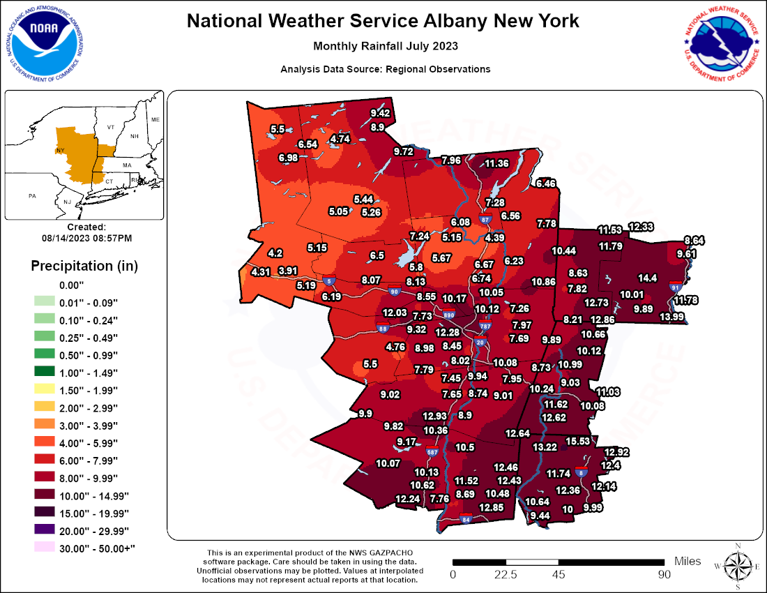 |
| July 2023 Total Rainfall |
Monthly Precipitation Totals For July 2023
National Weather Service Albany NY

                         Total
 Location                Pcpn

  Eastern New York...Albany County
Albany 0.7 SW            8.61
Albany 0.9 SSE            M
Albany 2.4 WNW          12.28
Albany ASOS             10.70
Albany NWS ETEC         10.88
Albany RAWS             11.74
Alcove Dam               8.02
Altamont 0.4 SE         10.66
Altamont 2.7 SSW         9.32
Altamont 3.5 NW          7.73
Colonie  3.6 WNW        11.01
Delmar 1.0 S             8.45
East Berne 2.7 NE        9.72
Glenmont 2.5 SW          6.40
Ravena 1.4 NNW            M
Rensselaerville 2.1 NNW  8.98

  Eastern New York...Columbia County
Ancramdale 0.2 N        12.64
Chatham 0.7 SW           7.95
Germantown 0.6 E         8.90
Mellenville 0.3 ENE      9.01
Valatie 0.5 S            9.94
Valatie 2.9 N           10.08
Valatie 3.2 NE           9.90

  Eastern New York...Dutchess County
Beacon Hills RAWS       10.01
Beacon 0.7 SE             M
Hillside Lake 0.9 N     12.25
Hopewell Jct 2.8 NE     12.85
Hyde Park 1.5 E           M
Lagrangeville 3.4 NE    10.48
Millbrook 2.5 NE        12.46
Millbrook 3.2 SE        12.43
Pleasant Valley 1.7 S   11.52
Poughkeepsie 2.4 S       8.81
Poughkeepsie 3.9 SSE     8.69
Poughkeepsie 5.3 S       7.76
Poughkeepsie ASOS        7.52
Red Hook 1.2 NNE         8.66
Red Hook 1.7 N           7.57
Rhinebeck 3.4 N         10.50

  Eastern New York...Fulton County
Broadalbin 4.7 ESE       5.80
Northville               5.02
Northville 0.6 NE        7.04
Northville 0.6 N         7.24
Peck Lake                6.50

  Eastern New York...Greene County
Athens 0.3 WNW           8.74
Athens 2.2 NNW           7.65
Freehold 3.4 E           7.45
Greenville 0.7 E         7.79
Lexington 1.5 N          9.02

  Eastern New York...Hamilton County
Hoffmeister 2.0 E        5.05
Indian Lake              9.72
Lake Pleasant RAWS       4.74
Lake Pleasant 2.3 WSW    5.44
Long Lake 0.1 SSE        8.90
Long Lake 1.2 N          9.42
Speculator 10.0 SSW      5.26

  Eastern New York...Herkimer County
Big Moose 3 SE           6.54
Herkimer 0.6 SSE         3.91
Ilion 0.7 WSW            4.31
Jordanville 4.2 E        5.19
Old Forge COOP           6.98
Salisbury Center 1.8 NW  5.15
Schuyler 3.3 NE          4.20
Stillwater Resvr         5.50

  Eastern New York...Montgomery County
Amsterdam 1.0 NNW        8.13
Fonda 5.2 W              8.07
Fort Plain 0.2 SE        6.05
Hessville 1.8 WSW        6.19

  Eastern New York...Oneida County
Boonville 0.2 NW         3.58
Durhamville 3.5 NNW      3.69
Holland Patent 0.6 ESE   5.49
Holland Patent 1.1 WNW   5.06
New Hartford 0.8 S       3.09
New Hartford 1.0 WSW     5.69
Point Rock 0.6 SE        3.65
Prospect 0.7 WNW         6.36
Rome 4.8 SSE             4.00
Rome ASOS                3.27
Sauquoit  1.6 WSW        4.35
Sylvan Beach 1.6 NW      3.65
Whitesboro 0.2 W         3.78

  Eastern New York...Rensselaer County
Averill Park 0.9 WNW     7.69
Averill Park 1.2 NW       M
Buskirk                 10.86
Poestenkill 1.0 ESE      7.97
Rennselaer 1.5 S         8.59
Troy Lock & Dam           M
Troy 0.7 E               9.78
Troy 2.1 NNE             8.84
Troy 6.9 NE              7.26
Wyantskill 2.6 SW       10.04

  Eastern New York...Saratoga County
Ballston Spa 2.9 ESE      M
Clifton Park 2.0 S       9.75
Clifton Park 2.7 S      10.12
Conklingville Dam        6.08
Gansevoort 3.7 WNW       4.39
Greenfield Ctr 1.6 W     5.87
Malta 2.6 NNW            6.74
Mechanicville 2.4 SW    10.05
Mechanicville 3.4 WSW   10.77
Milton 5.2 NNW           5.67
Providence 2.3 E         4.79
Round Lake 2.7 N         8.73
Saratoga RAWS             M
Saratoga Sprgs 0.5 S     6.67
Saratoga Springs 4SW     6.85
Schuylerville 1.6 SSW    6.23

  Eastern New York...Schenectady County
Amsterdam 6.4 E          8.55
Delanson 2 NE           12.03
Niskayuna 0.4 S          8.75
Niskayuna 0.7 NE        12.11
Niskayuna 2.0 N         10.17
Niskayuna 2.9 SSE       11.03
Pattersonville 4.2 SSW   7.60
Schenectady 1.5 ENE      9.13
Scotia 1.1 NW            8.24

   Eastern New York...Schoharie County
Cobleskill 4.2 NNE        M
Jefferson 0.2 S           M
Lansing Manor            5.50
Middleburgh 6.3 ESE      4.76
Schoharie Village         M

   Eastern New York...Ulster County
Catskill Center RAWS     9.90
Highland 0.2 SW          8.08
Highland 2.3 NW         10.62
Highland 2.6 NNE        10.02
Hurley 0.1 NNW           9.17
Hurley 2.2 S             9.13
Kerhonkson 3.7 N        10.07
Mohonk Lake               M
New Paltz 2.4 SW        11.75
Plattekill 2.0 WNW      10.22
Phoenicia                9.82
Rosendale 1.8 WNW        9.53
Rosendale 2E             7.24
Saugerties 4.7 NW       12.93
Stoneridge 0.5 WNW      10.39
Stoneridge 0.7 N        10.13
Ulster Park 0.9 NNW      8.53
Wallkill 3.7 E          12.24
West Hurley 0.1 S        9.17
Woodstock 0.8 ENE       10.36

  Eastern New York...Warren County
Brant Lake 1.7 ENE      11.36
Glens Falls ASOS         4.52
Lake George 1.0 N        7.28
Lake George 5.0 ESE      6.56
Lake Luzerne             5.15
North Creek              7.96
Warrensburg 2.1 WNW       M

  Eastern New York...Washington County
Granville 9.5 SW         7.78
Salem 2.3 SSE           10.44
Whitehall                6.46

  Vermont...Bennington County
Bennington ASOS          8.31
Landgrove 1.1 NNE       12.33
Manchester 2.8 ENE      11.79
Peru                    11.53
South Shaftsbury 0.1 W   7.82
Shaftsbury 0.4 WNW       8.63
Stamford 5.0 NNE        12.73
Woodford RAWS             M

  Vermont...Windham County
Brattleboro 0.7 S       11.78
East Dover 1.8 N        14.40
Guildford 6.4 SSW       13.99
Marlboro                 9.89
Marlboro 2.0 NNE         9.49
Putney 0.7 NE           13.36
Rockingham 1.1 NNE       8.64
West Halifax 0.2 SE       M
Westminster 5.5 NW       9.61
Wilmington 0.6 WNW      10.01

  Massachusetts...Berkshire County
Adams 0.4 WNW           10.66
Alford 1.9 SW             M
Beckett 4.4 SSE         11.03
Beckett 5.6 SSW         10.08
Cheshire  0.5 NNW       10.12
Cheshire 2.6 N          10.33
Clarksburg 1.2 NE       12.86
Dalton 2.9 SW             M
Great Barrington 0.4 N  11.62
Great Barrington 3.0 N    M
Hancock 3.6 NNE          9.89
Lee 3.7 SE              11.46
Lenoxdale                9.03
North Adams ASOS         8.74
Pittsfield 2.8 W        10.99
Pittsfield ASOS          8.73
Pittsfield Airport       8.69
Sheffield 1.6 NW        12.62
Stockbridge 0.2 NNE     10.24
Stockbridge DCR         10.53
Williamstown 1.8 WNW     8.21

  Connecticut...Litchfield County
Bakersville             12.40
Canaan 4.2 ESE          13.22
Litchfield 2.3 NNE      11.74
Litchfield 5.3 ESE      12.36
New Hartford CTR 1.5 N  12.92
New Hartford CTR 3.2 SW 11.59
New Milford 3.1 WNW     10.64
New Milford 5.3 SSW      9.44
Norfolk 2SW             15.53
Salisbury 3.8 NE          M
South Kent 0.1 SE       11.44
Thomaston Dam           12.14
Warren 2.4 WNW          11.71
Watertown 0.5 S          9.99
Watertown 3.4 N         12.28
Winsted 3.8 ESE         13.98
Woodbury Center 1.5 SSW 10.00

  Connecticut...Fairfield County
Bethel 0.5 E             8.34
Bethel 3.5 NNE           8.13
Bethel 4.5 SSE           7.91
Bridgeport 2.2 NNE        M
Bridgeport 2.9 NNW       8.68
Brookfield 3.3 SSE      10.38
Danbury  ASOS            5.27
Darien 1.8 ENE           6.95
Darien 2.4 NW            6.42
Darien 3.6 N              M
Fairfield 1.1 SSE         M
Fairfield 1.5 NE         5.65
Monroe 0.8 W             8.12
New Canaan 1.9 ENE       6.99
New Canaan 3.8 N         8.02
Newtown 4.6 SE           7.35
Norwalk 1.4 ENE          8.82
Norwalk 2.9 NNW          6.57
Redding 1.4 E             M
Ridgefield 2.4 NNE       9.78
Ridgefield 3.6 N        10.48
Ridgefield 3.7 NNE      10.05
Shelton 1.3 W            6.65
Shelton 2.3 WSW           M
Stratford 0.2 ESE        7.68
Stratford 0.9 W          8.07
Trumbull 0.9 W           8.34
Trumbell 1.2 S            M
Westport 2.5 ENE         6.65
Westport 3.8 ENE          M
Wilton 1.9 NW             M

END
--------------------------------------------------------------
These data are preliminary and have not undergone final quality
control by the National Centers for Environmental Information
(NCEI). Therefore, these data are subject to revision. Final
and certified climate data can be accessed at www.ncei.noaa.gov.
--------------------------------------------------------------
 |
Media use of NWS Web News Stories is encouraged! Please acknowledge the NWS as the source of any news information accessed from this site. |
|

