Overview
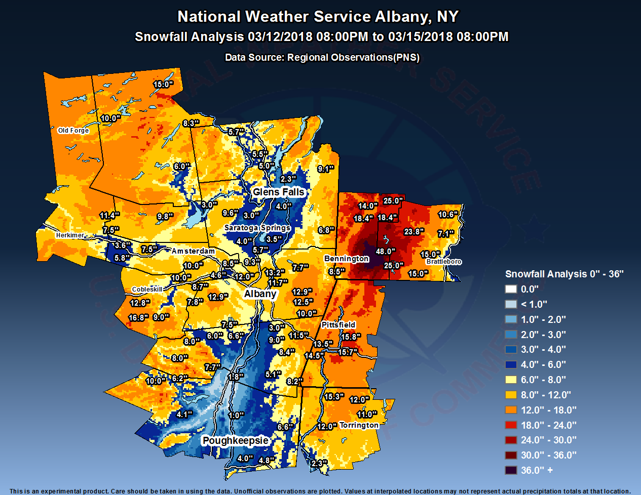
Shortly after midnight on Tuesday, March 13th, a rapidly developing area of low pressure was off the mid-Atlantic coast. Light snow began to overspread the region during the early morning hours and began to increase in intensity towards daybreak. Much of the snow was located from the Hudson Valley on eastward, with the steadiest and heaviest snowfall over the Taconics and into southern Vermont and eastern parts of the Berkshires. During the day on Tuesday, this low pressure lifted northeast and was located well east of Cape Cod by late in the day on March 13th, when pressure dropped to around 968 mb. Despite the storm taking a rather far easterly track, our area saw fairly steady snowfall through the day, thanks to a large upper level low that tracked across the Great Lakes and along the NY/PA border region.
Even into the evening hours, areas of snowfall continued, especially across eastern parts of the Capital Region, thanks to a combination of strong upper level lift and low-level convergence. By the early-morning on Wednesday, March 14th, the steady accumulating snowfall became more tied to upslope and lake-enhanced areas, and most valley areas were not seeing much additional accumulation at this time, as the large upper level low slowly slid eastward into New England through the day on Wednesday.
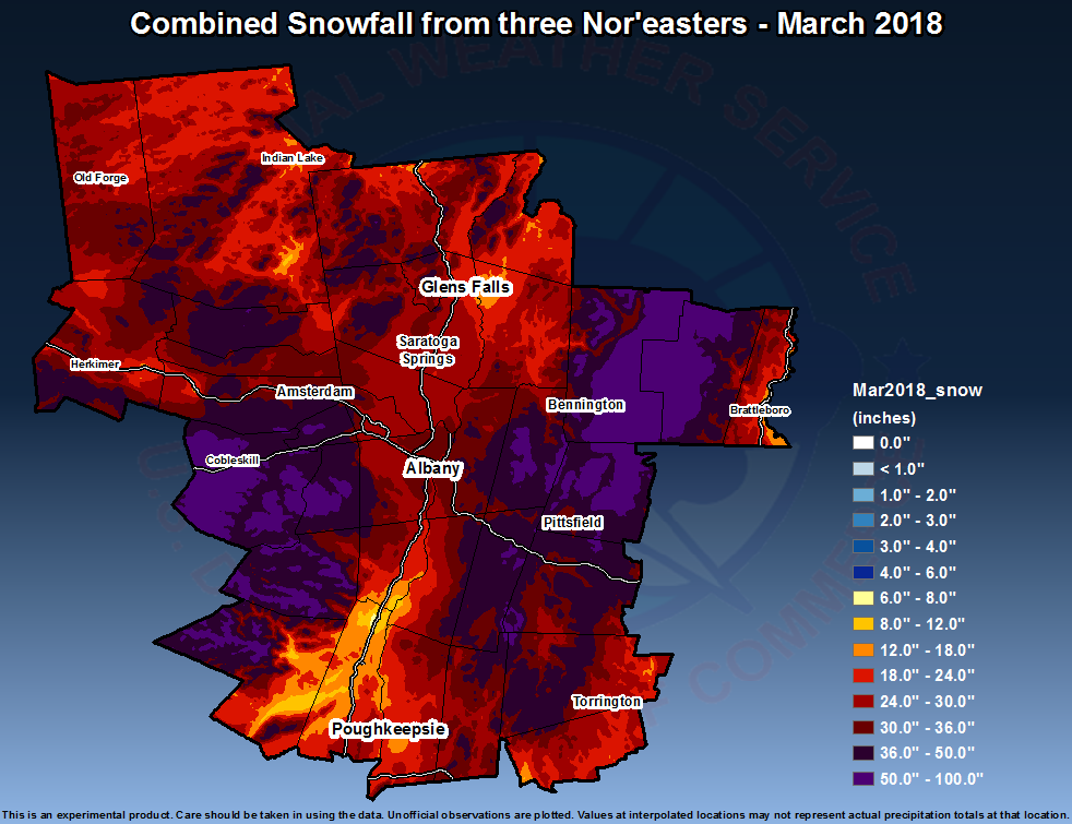
The cyclonic, moist flow and westerly winds allowed for upslope across western New England, the western Adirondacks and the Taconics into early parts of the day on Thursday, March 15th, as the upper level low finally lifted towards Atlantic Canada. Moisture started to become more limited during the day on Thursday, which allowed upslope snowfall to slowly dwindle down and end. 3-day totals across these upslope areas were significant across western New England, with up to 48 inches locally in Woodford, VT. Snowfall totals were variable elsewhere, with around a foot in portions of the Capital District, Catskills, Schoharie Valley, southern Adirondacks, and northwest Connecticut. The Berkshires generally saw 12-18", while the Lake George Saratoga Region and Mid-Hudson Valley saw only a few inches.
This was the third heavy snowfall event in the first half of March, 2018. Albany recorded around a foot of snow in each of the events, bringing their March total to 36.0" through the 15th, and making 2018 the third snowiest March on record. An observer in Woodford, VT, reported an incredible 98" in these three storms!
March 1-15 Snow Totals
Estimated snowfall totals from the March 2, March 7-8, and March 13-15 Nor'Easters:
Radar:
KENX radar loop from 4:00 pm Monday, March 12 through 7:00 am Thursday, March 15, 2018. Images are displayed every hour. Loop courtesy Iowa Environmental Mesonet.
.gif) |
Storm Reports
Public Information Statement
Spotter Reports
National Weather Service Albany NY
125 PM EDT Fri Mar 16 2018

The following are final unofficial observations taken during the
storm that impacted our region March 13-15. Appreciation is extended
to highway departments, cooperative observers, Skywarn spotters and
media for these reports. This summary also is available on our home
page at weather.gov/albany

********************STORM TOTAL SNOWFALL********************

LOCATION          STORM TOTAL     TIME/DATE   COMMENTS
                     SNOWFALL           OF
                     /INCHES/   MEASUREMENT

CONNECTICUT

...Litchfield County...
   Norfolk               15.3   800 AM  3/15  Co-Op Observer
   5 NNW Winsted         12.0   700 AM  3/15  CoCoRaHS
   4 SSW Cornwall Bridg  12.0   700 AM  3/15  CoCoRaHS
   Bakersville           11.0   700 AM  3/15  Co-Op Observer
   5 SSW New Milford      2.3   800 AM  3/15  CoCoRaHS

MASSACHUSETTS

...Berkshire County...
   Lenoxdale             15.8   823 AM  3/15  Co-Op Observer
   5 NW Otis             15.7   700 AM  3/15  CoCoRaHS
   1 SE Housatonic       14.5   700 AM  3/15  CoCoRaHS
   3 NE Housatonic       13.5   600 AM  3/15  CoCoRaHS

NEW YORK

...Albany County...
   2 SSW Altamont        12.9   655 AM  3/15  CoCoRaHS
   1 NE Shakers          12.0   800 PM  3/14  Albany Int'l Airport
   Latham                10.0  1030 PM  3/13  Broadcast Media
   Colonie                9.0  1030 PM  3/13  Broadcast Media
   1 W Albany             8.8   700 AM  3/14  CoCoRaHS
   2 W Albany             8.8   815 AM  3/14  Retired NWS Emp.
   Knox                   8.7  1125 AM  3/14  WeatherNet6
   Boght Corners          8.4   629 AM  3/14  NWS Employee
   Albany                 6.9   800 AM  3/14  NWS Albany Office

...Columbia County...
   Austerlitz            11.5  1051 PM  3/13  WeatherNet6
   Chatham                9.0  1053 PM  3/13  WeatherNet6
   5 SW Austerlitz        8.4   800 AM  3/14  CoCoRaHS
   Ancramdale             8.2   555 PM  3/14  WeatherNet6
   Taghkanic              5.1   529 PM  3/13  WeatherNet6
   Kinderhook             3.0  1228 PM  3/14  Trained Spotter

...Dutchess County...
   3 SE Millbrook         6.6   700 AM  3/15  CoCoRaHS
   6 ESE Pleasant Valle   6.0   700 AM  3/15  CoCoRaHS
   2 SSE Hopewell Junct   4.8   700 AM  3/15  CoCoRaHS
   1 NE Fishkill          4.0   700 AM  3/14  CoCoRaHS

...Fulton County...
   7 NW GLOVERSVILLE      9.8   700 AM  3/15  Co-Op Observer

...Greene County...
   West Kill              8.0  1108 PM  3/13  WeatherNet6
   Windham                8.0  1030 PM  3/13  Broadcast Media
   Platte Clove           7.7   700 AM  3/15  Co-Op Observer
   7 SSE Westerlo         7.5   500 AM  3/15  CoCoRaHS
   4 NNE Cairo            6.6   516 AM  3/15  CoCoRaHS
   Greenville Center      6.0   500 AM  3/14  WeatherNet6

...Hamilton County...
   Long Lake             15.0   700 AM  3/15  CoCoRaHS
   Inlet                 10.0   550 PM  3/14  Trained Spotter
   2 SW Indian Lake       8.3   809 AM  3/15  Co-Op Observer
   Wells                  6.0  1137 AM  3/15  WeatherNet6

...Herkimer County...
   West Winfield         13.0   750 PM  3/14  Trained Spotter
   2 NW Dolgeville       11.4   715 AM  3/15  CoCoRaHS
   Ilion                  9.6   730 AM  3/15  CoCoRaHS
   Dolgeville             7.5   530 AM  3/15  Trained Spotter

...Montgomery County...
   1 NW Amsterdam        10.7   830 AM  3/14  CoCoRaHS
   Palatine Bridge        7.5   542 AM  3/14  WeatherNet6
   Amsterdam              6.5   502 PM  3/14  WeatherNet6
   4 ENE East Springfie   5.8   800 AM  3/15  CoCoRaHS
   Hessville              5.7  1202 PM  3/13  WeatherNet6
   Fort Plain             3.6   700 AM  3/15  CoCoRaHS

...Rensselaer County...
   Troy                  13.2   700 AM  3/15  Co-Op Observer
   Averill Park          12.9   800 AM  3/15  CoCoRaHS
   1 WNW Averill Park    12.5   700 AM  3/14  Meteorologist
   2 NE Troy             11.7   700 AM  3/15  CoCoRaHS
   4 ESE Nassau          10.0   800 AM  3/15  CoCoRaHS
   1 N Sycaway            9.6  1150 PM  3/13  NWS Employee
   Center Brunswick       9.0  1049 PM  3/14  WeatherNet6
   Petersburg             8.5  1202 PM  3/14  WeatherNet6
   5 E Waterford          7.7   700 AM  3/15  CoCoRaHS

...Saratoga County...
   Lake Desolation        9.6   250 PM  3/14  WeatherNet6
   2 SE Clifton Park      9.3   605 AM  3/14  CoCoRaHS
   2 S Clifton Park Cen   7.1   921 AM  3/14  Retired NWS Emp.
   1 WSW Round Lake       5.7   800 AM  3/14  CoCoRaHS
   Ballston Lake          5.7   800 AM  3/14  NWS Employee
   1 W Gansevoort         4.0   600 AM  3/14  CoCoRaHS
   2 ESE Ballston Spa     4.0   845 AM  3/14  CoCoRaHS
   Saratoga Springs       3.6   600 AM  3/14  CoCoRaHS
   3 S Saratoga Lake      3.5   730 AM  3/14  CoCoRaHS
   1 SSE Porter Corners   3.0   745 AM  3/14  CoCoRaHS
   Edinburg               3.0   434 PM  3/13  WeatherNet6

...Schenectady County...
   4 SSW Pattersonville  10.0   800 AM  3/15  CoCoRaHS
   Delanson              10.0   632 PM  3/13  WeatherNet6
   1 SSW Aqueduct         8.5   640 AM  3/14  NWS Employee
   Glenville              8.0   537 PM  3/14  WeatherNet6
   1 NNW Niskayuna        6.5   912 PM  3/13  NWS Employee
   South Schenectady      4.6   900 AM  3/14  NWS Employee

...Schoharie County...
   Jefferson             16.8   518 AM  3/15  WeatherNet6
   Richmondville         12.8   555 PM  3/14  WeatherNet6
   Charlotteville        10.8   432 AM  3/15  WeatherNet6
   7 N North Blenheim     9.0   800 AM  3/15  Co-Op Observer
   Middleburgh            7.8   436 AM  3/15  WeatherNet6
   2 ESE Cobleskill       6.0   735 AM  3/15  Co-Op Observer

...Ulster County...
   Highmount             10.0   813 AM  3/14  WeatherNet6
   Phoenicia              6.2   612 AM  3/15  Co-Op Observer
   3 N Kerhonkson         4.1   700 AM  3/15  CoCoRaHS
   Saugerties             1.8   629 PM  3/13  WeatherNet6
   Esopus                 1.0   450 PM  3/13  WeatherNet6

...Warren County...
   5 SE North Creek       5.7   700 AM  3/14  Co-Op Observer
   2 WNW Warrensburg      5.5   800 AM  3/15  CoCoRaHS
   Warrensburg            5.0   451 PM  3/14  WeatherNet6
   3 NNE Glens Falls      2.3   700 AM  3/14  CoCoRaHS

...Washington County...
   4 NE Hartford          9.1   600 PM  3/14  Emergency Manager
   Cambridge              6.8   843 AM  3/14  Public

VERMONT

...Bennington County...
   Woodford              48.0   552 PM  3/15  WeatherNet6
   Landgrove             25.0   541 PM  3/15  WeatherNet6
   1 WNW Weston          24.0   700 AM  3/15  CoCoRaHS
   Manchester Center     18.4  1048 AM  3/15  WeatherNet6
   1 E Manchester Cente  18.4   700 AM  3/15  CoCoRaHS
   1 ENE Manchester Cen  14.0  1200 AM  3/15  8" in last 24 hours

...Windham County...
   1 WNW Wilmington      25.0   557 AM  3/15  CoCoRaHS
   1 ESE West Wardsboro  23.8   719 AM  3/15  CoCoRaHS
   Jacksonville          15.0  1030 PM  3/13  Broadcast Media
   Marlboro              15.0   100 PM  3/13  Broadcast Media
   3 WSW Charlestown     10.6   700 AM  3/15  CoCoRaHS
   2 NNW Putney           7.1   700 AM  3/15  CoCoRaHS
 |
Media use of NWS Web News Stories is encouraged! Please acknowledge the NWS as the source of any news information accessed from this site. |
|

