Overview
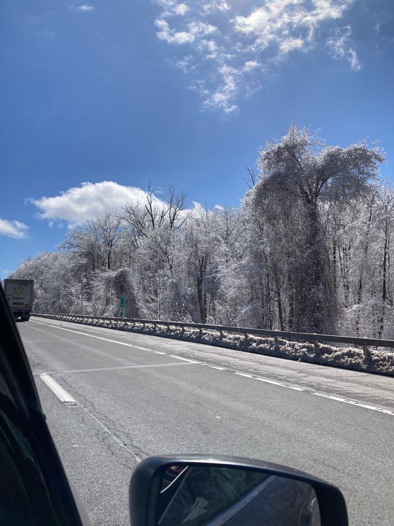
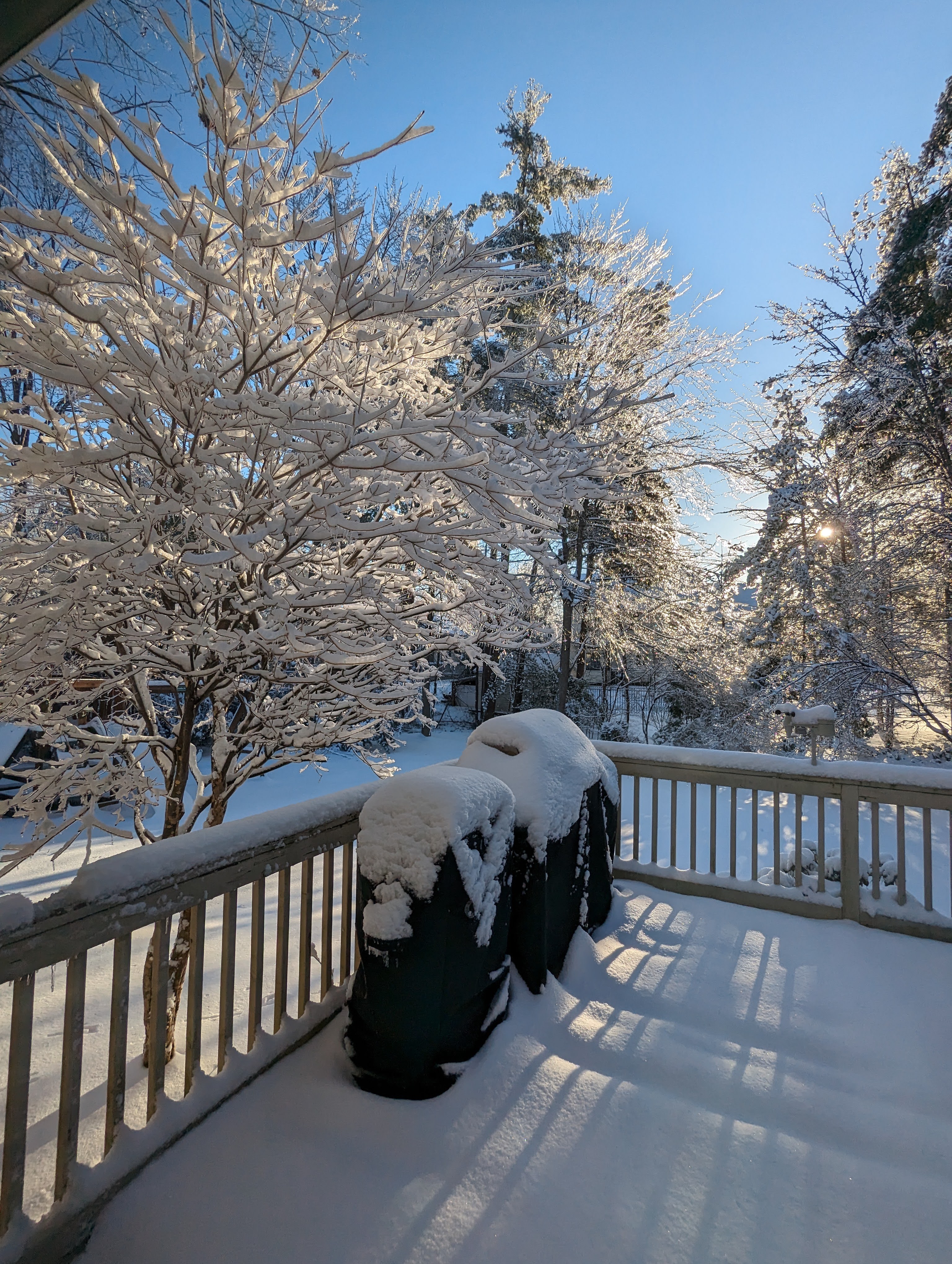
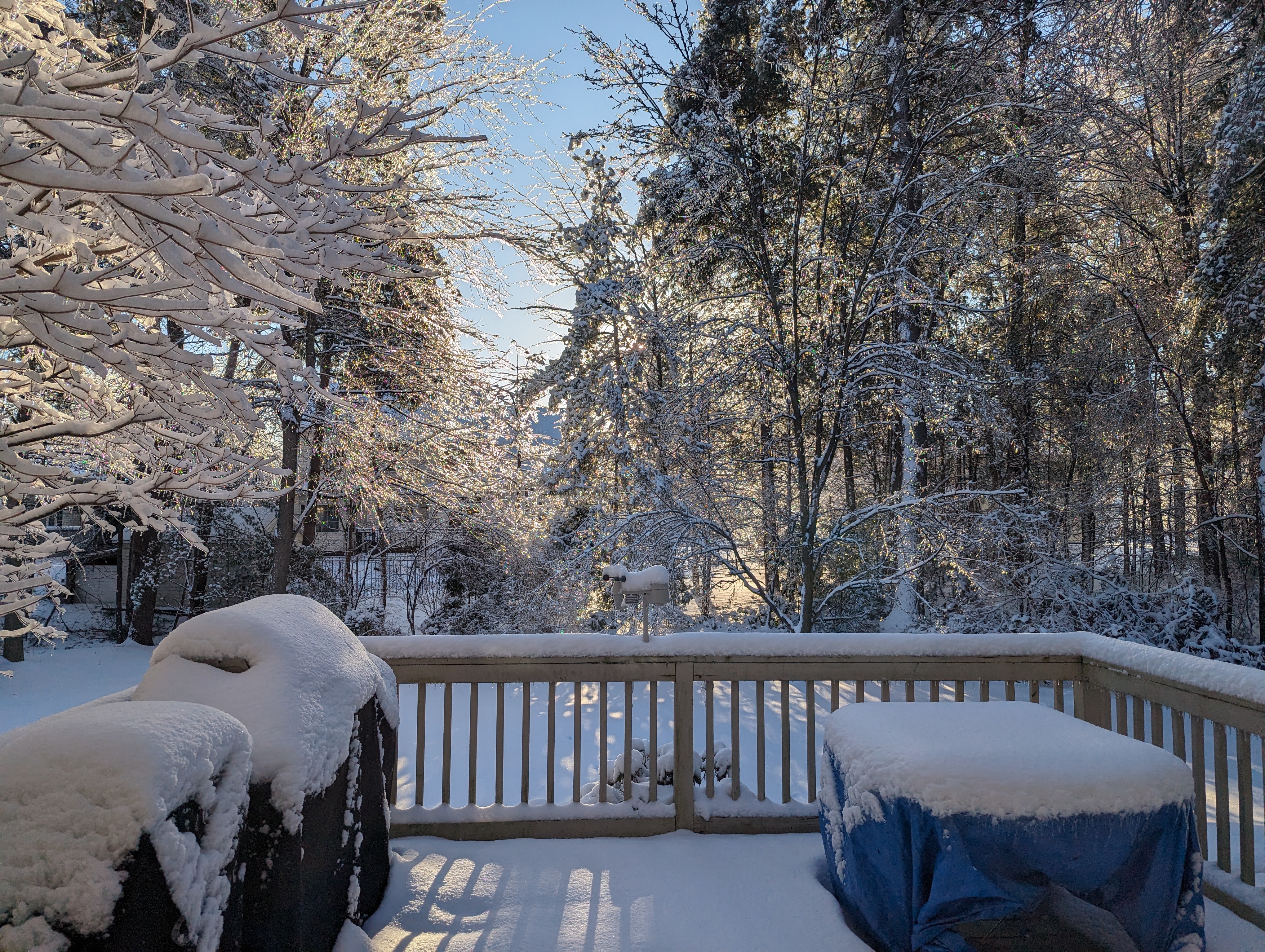
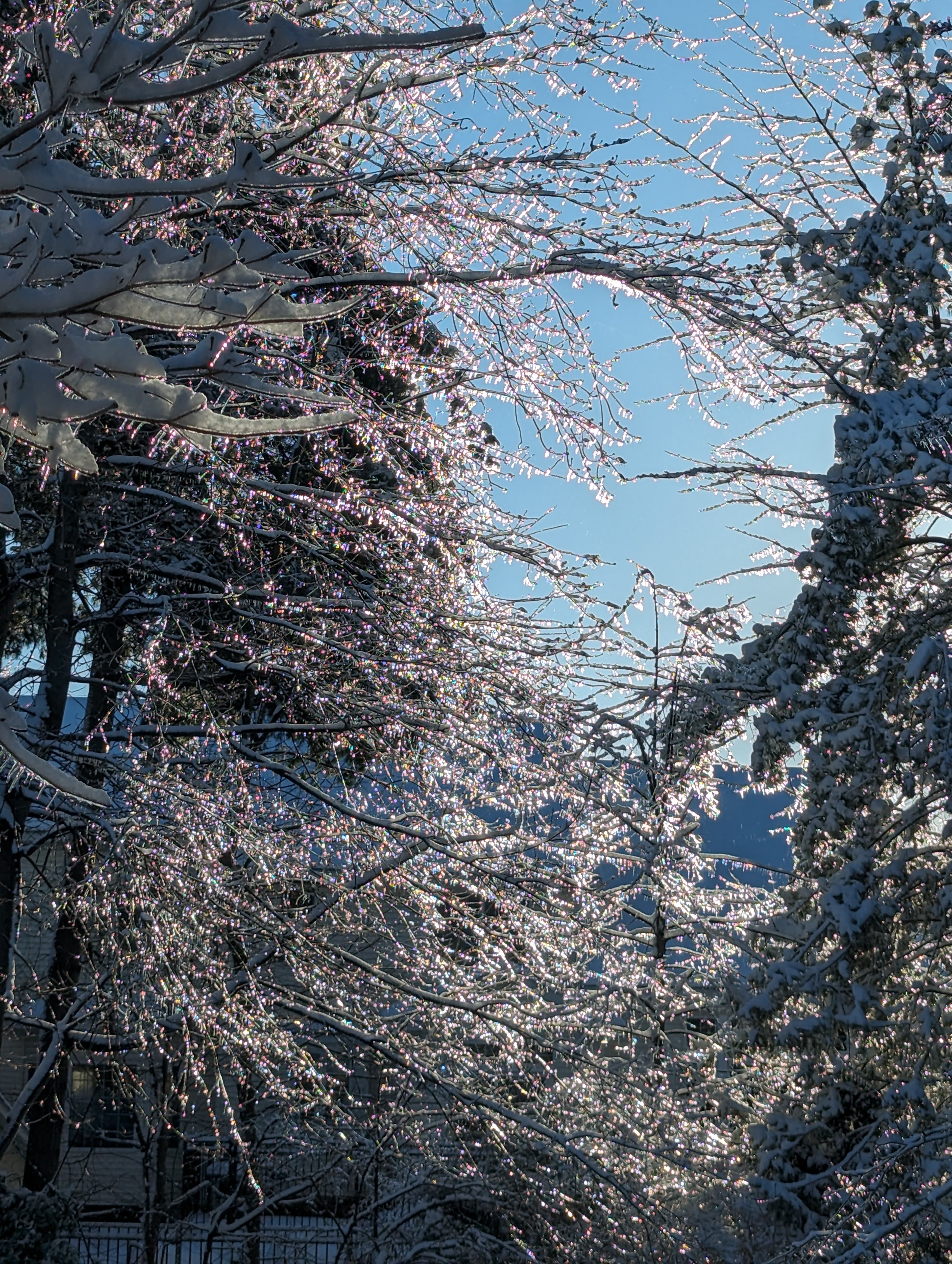
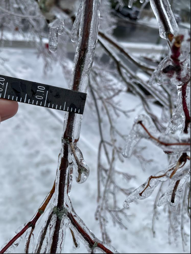
A moisture rich and long duration coastal storm producing all precipitation types including soaking rain, heavy snowfall rates, sleet and freezing rain impacted eastern NY and western New England beginning the evening of Friday March 22 and continued through the evening of Saturday March 23. A snow band producing moderate to heavy snow with snowfall rates reaching 1-2" per hours persisted across the Mohawk Valley, southern Adirondacks and Lake George/Saratoga region into the higher elevations of southern Vermont resulting in the first widespread double digit snow event of the year. A few locations in southern VT even eclipsed 30 inches due to upslope enhancements. While a period of snow initially started across the Schoharie Valley and Capital District the night of Friday March 22, it transitioned to sleet/freezing rain before or around daybreak on Saturday March 23. Steady freezing rain continued throughout the morning into the early afternoon as air temperatures remained at or just below freezing. Few areas changed over to plain rain in this region as temperatures did not budge. While ice stopped accreting on many road surfaces by late morning and early afternoon, ice continued to accrete across elevated surfaces including trees. Given the the prolonged nature of steady to even moderate freezing rain and temperatures persisting around nearly ideal temperatures for efficient ice accretion, the weight of the ice resulted in tree limbs and even some tree breaking and falling. This led to numerous power outages that lasted for over 24 hours in some spots of the Capital District. After an impressive 0.50 - 0.75 inches of flat ice accreted, freezing rain changed back to a burst of moderate to heavy snow during the late afternoon hours on March 23 producing an additional quick 2 - 4 inches before ending in the evening.
Farther south in the mid-Hudson Valley, eastern Catskills, and Litchfield Hills plain rain or mixed rain/freezing rain occurred. Some light ice accretions occurred across the eastern Catskills. In Berkshire County, initial snow/ice mix transitioned to plain rain in some valley areas but higher elevations remained a wintry mix through much of the event. A light amount of snow, then ice occurred across the Litchfield Hills into early morning before changing to all rain through the rest of the event. With rainfall totals near or in excess of 3 inches across the mid-Hudson Valley and Litchfield Hills, rises above minor flood stage occurred, necessitating river flood warnings on the Housatonic and Still Rivers in northwestern Connecticut.
Photos & Video
 |
 |
 |
 |
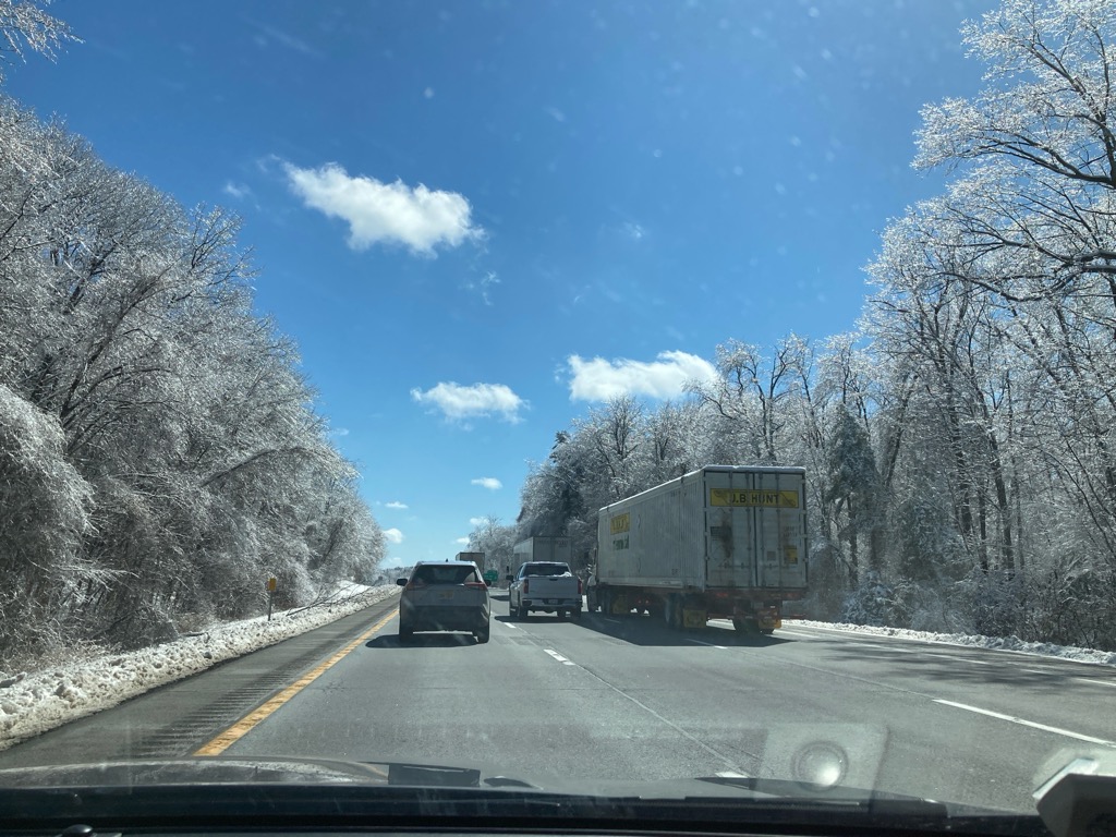
| View of icy trees on I-87 (Northway) in southern Saratoga County Sunday March 24, 2024 Courtesy of Christina Speciale NWS Albany |
Icy trees on I-87 (Northway) in southern Saratoga County Sunday March 24, 2024 Courtesy of Christina Speciale NWS Albany |
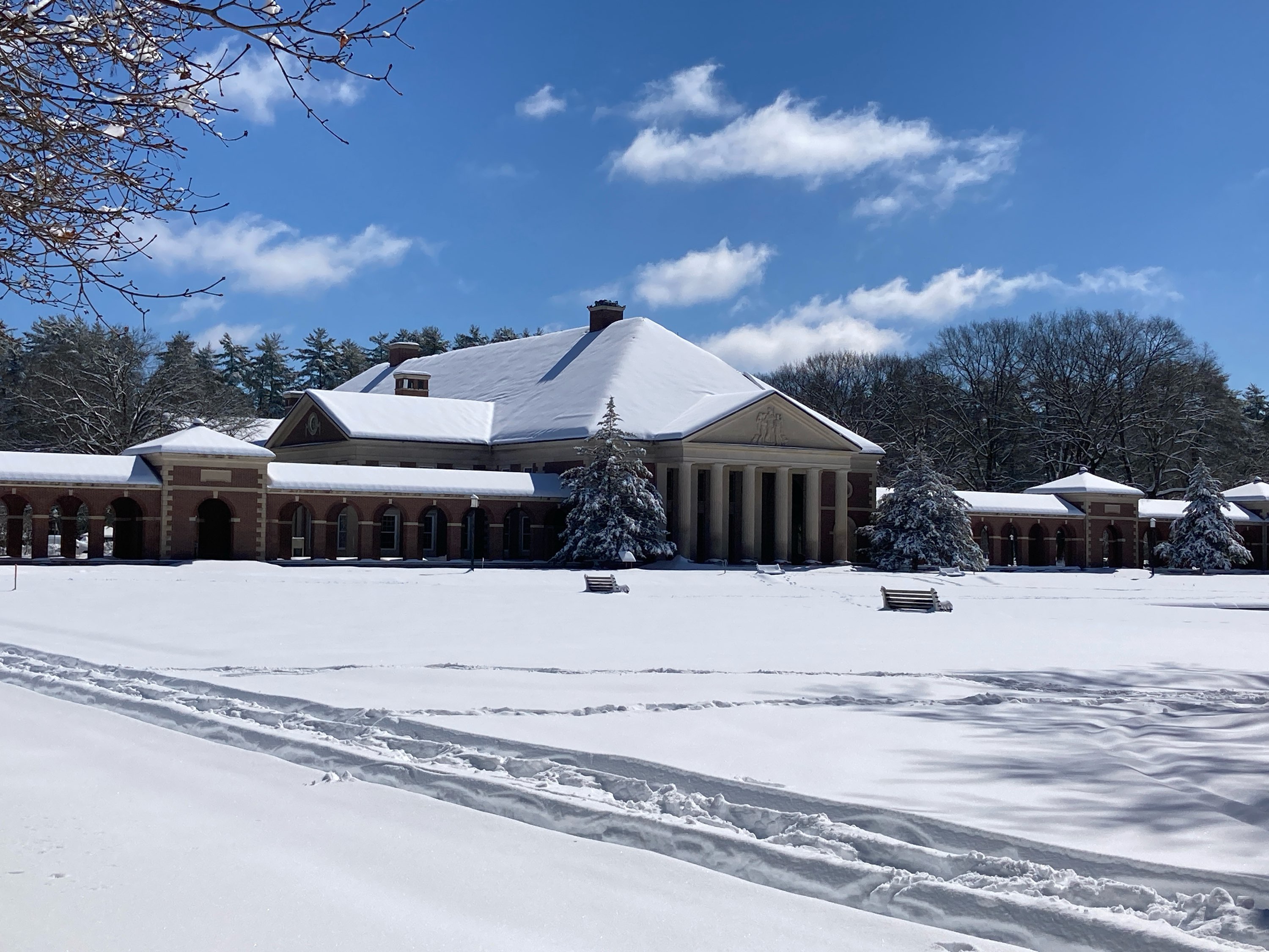
Over a foot of snow blanketed Saratoga Spa State Park Sunday March 24, 2024 Courtesy of Christina Speciale NWS Albany |
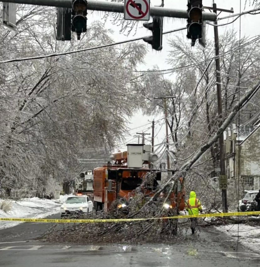
Tree and power line damage in Troy, NY on Saturday March 23, 2024 Courtesy of Dave Lucas, WAMC Northeast Public Radio |
 |
 |
 |
 |
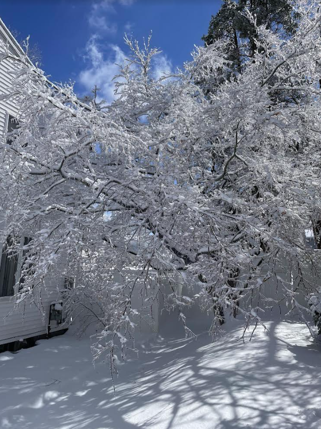
| Snow and ice covered tees in Guilderland March 23, 2024 Courtesy of Brian Frugis NWS Albany |
Snow and ice covered trees in Guilderland March 23, 2024 Courtesy of Brian Frugis NWS Albany |
Ice covered trees in Guilderland March 23, 2024 Courtesy of Brian Frugis NWS Albany |
0.20" of radial ice on a tree branch in Albany March 23, 2024 Courtesy of Joe Villani NWS Albany |
 |
 |
||
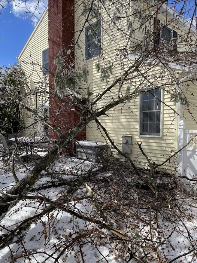
| Tree falls on a house in Albany due to weight of ice March 23, 2024 Courtesy of Joe Villani NWS Albany |
Ice covered trees in Albany March 23, 2024 Courtesy of Joe Villani NWS Albany |
Radar
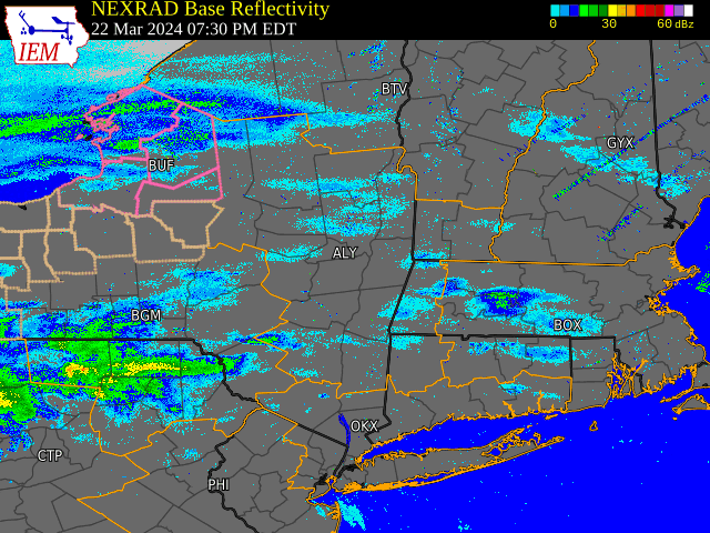 |
| Radar imagery loop from the evening of March 23 through the evening of March 24, 2024 |
Snow, Ice and Precipitation Reports
-IceAccumAnalysisPublic3.png)
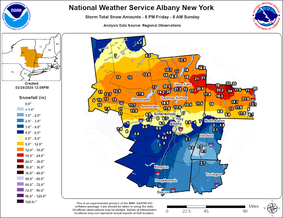
Storm Total Flat Ice Map Storm Total Snowfall Map
Public Information Statement
Spotter Reports
National Weather Service Albany NY
1232 PM EDT Mon Mar 25 2024

The following are unofficial observations taken during the past 46
hours for the storm that has been affecting our region. Appreciation
is extended to highway departments, cooperative observers, Skywarn
spotters and media for these reports. This summary also is available
on our home page at weather.gov/albany

**********************STORM TOTAL ICE***********************

LOCATION                TOTAL      TIME/DATE  COMMENTS
                          ICE       MEASURED
                     (inches)

CONNECTICUT

...Litchfield County...
  2 NNE Litchfield       0.10   209 PM  3/24  CoCoRaHS

MASSACHUSETTS

...Berkshire County...
  Pittsfield Municipal   0.28   700 AM  3/24  Flat ice
  Alford                 0.25   830 PM  3/23  0.10 radial ice.
  Harriman-and-west-Ai   0.10   700 AM  3/24  Flat ice

NEW YORK

...Albany County...
  Latham                 0.75   918 PM  3/23  NWS Employee
  2 W Albany             0.66   736 PM  3/23  Retired NWS Emp.
  Albany                 0.55   800 PM  3/23  NWS Albany Office
  3 NW Guilderland       0.50   800 AM  3/24  NWS Employee
  Boght Corners          0.50  1000 PM  3/23  NWS Employee
  Albany Intl AP         0.44   700 PM  3/23  Flat Ice
  1 SSE Westmere         0.40   205 PM  3/24  Trained Spotter

...Dutchess County...
  1 NNE Red Hook         0.10   700 AM  3/24  CoCoRaHS

...Rensselaer County...
  1 N Sycaway            0.50   513 PM  3/23  NWS Employee
  1 NNE North Greenbus   0.50   600 PM  3/23  Trained Spotter

...Saratoga County...
  Halfmoon               0.30   700 PM  3/23  Social Media
  2 S Clifton Park Cen   0.25   758 PM  3/23  Retired NWS Emp.

...Schenectady County...
  1 NE Stanford Height   0.30  1000 PM  3/23  0.3 inches of flat ice

...Warren County...
  Floyd Bennett Memori   0.01   700 PM  3/23  Flat Ice

VERMONT

...Bennington County...
  Bennington State Air   0.25   700 AM  3/24  Flat ice
Public Information Statement
Spotter Reports
National Weather Service Albany NY
1158 AM EDT Sun Mar 24 2024

The following are unofficial observations taken during the past 28
hours for the storm that has been affecting our region. Appreciation
is extended to highway departments, cooperative observers, Skywarn
spotters and media for these reports. This summary also is available
on our home page at weather.gov/albany

**********STORM TOTAL SNOWFALL (AT LEAST 0.1 INCH)**********

LOCATION                TOTAL      TIME/DATE  COMMENTS
                     SNOWFALL       MEASURED
                     (inches)

CONNECTICUT

...Litchfield County...
  Falls Village           2.7   730 AM  3/24  Trained Spotter

MASSACHUSETTS

...Berkshire County...
  Williamstown            5.2  1000 PM  3/23  Storm total
  Savoy                   3.9  1150 PM  3/23  WeatherNet6
  1 NNW Cheshire          2.7   700 AM  3/24  CoCoRaHS
  Pittsfield              2.5   812 AM  3/24  Weathernet6
  3 N Cheshire            2.0   700 AM  3/24  CoCoRaHS
  Alford                  0.2   830 PM  3/23  Trained Spotter
  2 SW Alford             0.2   830 AM  3/24  CoCoRaHS
  N Great Barrington      0.1  1159 PM  3/23  CoCoRaHS

NEW YORK

...Albany County...
  Latham                  8.0   800 AM  3/24  Trained Spotter
  4 NW Altamont           8.0   700 AM  3/24  CoCoRaHS
  Knox                    7.5   812 PM  3/23  WeatherNet6
  3 NW Guilderland        6.7   800 AM  3/24  NWS Employee
  2 NW Latham             6.5   700 AM  3/24  CoCoRaHS
  3 SSW Altamont          6.2   655 AM  3/24  CoCoRaHS
  Loudonville             6.0   753 PM  3/23  WeatherNet6
  Delmar                  6.0  1223 AM  3/24  WeatherNet6
  Albany Intl AP          5.9   800 AM  3/24  Storm total snow.
  Albany                  5.6   800 PM  3/23  NWS Albany Office
  NWS Albany              5.6   800 AM  3/24  CoCoRaHS
  Berne                   5.5  1154 PM  3/23  WeatherNet6
  2 W Albany              5.5   736 PM  3/23  Retired NWS Emp.
  1 SW Albany             5.5   700 AM  3/24  CoCoRaHS
  Colonie                 5.5   801 PM  3/23  WeatherNet6
  Boght Corners           5.4  1000 PM  3/23  NWS Employee
  Alcove Reservoir        4.5   730 AM  3/24  Co-Op Observer
  Cohoes                  4.0   849 PM  3/23  WeatherNet6

...Columbia County...
  1 SW Chatham            2.7   700 AM  3/24  CoCoRaHS

...Fulton County...
  Gloversville 7nw       17.6   700 AM  3/24  Co-Op Observer
  Broadalbin             17.0  1239 PM  3/23  Social Media
  1 NE Northville        17.0   720 AM  3/24  CoCoRaHS
  Perth                  15.0  1212 AM  3/24  WeatherNet6

...Greene County...
  1 E Greenville          5.6   700 AM  3/24  CoCoRaHS
  3 E Freehold            5.0   530 AM  3/24  CoCoRaHS
  Greenville Center       5.0   749 AM  3/24  WeatherNet6
  1 SSW Acra              3.0   700 AM  3/24  CoCoRaHS
  Freehold                2.5   645 AM  3/24  WeatherNet6

...Hamilton County...
  2 WNW Hoffmeister      13.0   800 AM  3/24  CoCoRaHS
  Wells                  12.5   642 PM  3/23  WeatherNet6
  2 WSW Lake Pleasant    12.4   655 AM  3/24  CoCoRaHS
  Piseco                 12.0   649 PM  3/23  WeatherNet6
  Indian Lake             8.3   820 AM  3/24  Co-Op Observer
  Inlet                   7.0   130 PM  3/23  Trained Spotter
  Long Lake               5.2   127 PM  3/23  Trained Spotter
  1 N Long Lake           2.7   700 AM  3/24  CoCoRaHS

...Herkimer County...
  2 SSW Salisbury        13.7   914 PM  3/23  Trained Spotter
  1 SW Dolgeville        13.0   500 PM  3/23  Trained Spotter
  East Herkimer          13.0  1025 AM  3/23  Social Media
  Dolgeville             12.5   915 PM  3/23  Storm total
  2 NW Salisbury Cente   12.5   700 AM  3/24  CoCoRaHS
  Ilion                  12.0   200 PM  3/23  Social Media
  1 SSW North Ilion      11.5  1245 PM  3/23  Trained Spotter
  3 NE Schuyler          11.0   900 AM  3/24  Trained Spotter
  Elizabethtown          10.0   958 AM  3/23  Trained Spotter
  1 NNE Cranes Corners    9.0  1245 PM  3/23  Trained Spotter
  1 SSE Cullen            7.5  1245 PM  3/23  Trained Spotter

...Montgomery County...
  1 NNW Amsterdam        15.7   824 AM  3/24  CoCoRaHS
  Amsterdam              15.6   701 PM  3/23  WeatherNet6
  1 ESE Fort Johnson     15.2   400 PM  3/23  Trained Spotter
  Fonda                  14.2  1153 PM  3/23  WeatherNet6
  SE Fort Plain          11.8   700 AM  3/24  CoCoRaHS
  5 W Fonda              11.7   300 PM  3/23  CoCoRaHS
  Palatine Bridge        11.5   750 AM  3/24  WeatherNet6
  2 WSW Hessville        11.0   700 AM  3/24  CoCoRaHS
  Hessville              11.0   725 PM  3/23  WeatherNet6

...Rensselaer County...
  Buskirk                11.5   738 PM  3/23  Trained Spotter
  Valley Falls           10.5   935 PM  3/23  WeatherNet6
  1 E Troy                9.5   700 AM  3/24  CoCoRaHS
  1 WNW Averill Park      9.5   818 PM  3/23  Meteorologist
  1 SSW Sherwood Park     8.0  1000 PM  3/23  Storm total
  Speigletown             7.0   715 AM  3/24  WeatherNet6
  Rensselaer              7.0   425 AM  3/24  WeatherNet6
  2 NNE Troy              6.4   600 AM  3/24  CoCoRaHS
  1 N Sycaway             6.2   717 PM  3/23  NWS Employee
  1 NNE North Greenbus    6.0   600 PM  3/23  Trained Spotter
  Petersburg              6.0   800 AM  3/24  WeatherNet6
  Sand Lake               4.0  1113 PM  3/23  WeatherNet6

...Saratoga County...
  Ganesvoort             21.2   758 AM  3/24  WeatherNet6
  Corinth                20.5   750 PM  3/23  Trained Spotter
  Porter Corners         20.0   930 AM  3/23  Facebook
  Lake Desolation        19.2  1119 PM  3/23  WeatherNet6
  Ballston Spa           18.5   742 AM  3/24  WeatherNet6
  Wilton                 18.0   206 PM  3/23  Social Media
  1 S Saratoga Springs   17.7   600 AM  3/24  CoCoRaHS
  Saratoga Springs       17.7  1108 PM  3/23  WeatherNet6
  4 WNW Rock City Fall   17.5   730 AM  3/24  CoCoRaHS
  Hickeys Corners        17.0   700 AM  3/24  Retired NWS Emp.
  2 W Greenfield Cente   16.5   800 AM  3/24  CoCoRaHS
  3 ESE Ballston Spa     15.0   800 AM  3/24  CoCoRaHS
  Ballston Lake          14.0   758 PM  3/23  NWS Employee
  Mechanicville          13.5  1206 AM  3/24  WeatherNet6
  1 E Kings Station      12.1   920 PM  3/23  Storm total
  Malta                  12.0   938 AM  3/24  WeatherNet6
  Gansevoort             12.0  1200 PM  3/23  Public
  Burnt Hills            11.5   724 PM  3/23  Trained Spotter
  1 E Saratoga Springs   10.5  1000 AM  3/23  Trained Spotter
  Clifton Park            8.5   832 AM  3/24  WeatherNet6
  2 S Clifton Park Cen    8.4   758 PM  3/23  Retired NWS Emp.
  3 S Clifton Park        5.9   640 AM  3/24  CoCoRaHS

...Schenectady County...
  1 NW Scotia            11.0   600 AM  3/24  CoCoRaHS
  Glenville              10.0   744 AM  3/24  WeatherNet6
  Scotia                  8.0   924 PM  3/23  WeatherNet6
  3 SSE Niskayuna         7.5   700 AM  3/24  CoCoRaHS
  1 NE Stanford Height    7.5  1000 PM  3/23  CoCoRaHS
  Delanson                6.5   651 PM  3/23  WeatherNet6
  Delanson 2ne            5.0   900 AM  3/24  Co-Op Observer
  Duanesburg              3.0   657 PM  3/23  WeatherNet6

...Schoharie County...
  Jefferson               8.0  1127 PM  3/23  WeatherNet6
  Charlotteville          7.5   656 PM  3/23  WeatherNet6
  Middleburgh             5.5   744 AM  3/24  WeatherNet6
  Richmondville           5.0   245 PM  3/23  WeatherNet6
  Lansing Manor           3.5  1000 AM  3/24  Co-Op Observer

...Warren County...
  Queensbury             20.0   659 AM  3/24  WeatherNet6
  Glens Falls            18.4   836 PM  3/23  Meteorologist
  Lake Luzerne           18.0   720 AM  3/24  WeatherNet6
  5 ESE Lake George      18.0   700 AM  3/24  CoCoRaHS
  1 N Lake George        17.1   800 AM  3/24  CoCoRaHS
  Warrensburg            17.0   829 PM  3/23  WeatherNet6
  2 N Forest Park Mobi   17.0   730 PM  3/23  Trained Spotter
  3 W Diamond Point      16.5   758 PM  3/23  Meteorologist
  Bolton Landing         14.0   808 PM  3/23  Trained Spotter
  Stony Creek            14.0   700 PM  3/23  Storm total
  2 WNW Warrensburg      12.7   800 AM  3/24  CoCoRaHS
  2 ENE Brant Lake       12.5   630 PM  3/23  Storm total
  3 S Lake Luzerne       11.0   600 AM  3/24  Co-Op Observer

...Washington County...
  Hartford               21.0  1219 AM  3/24  WeatherNet6
  Granville              21.0   833 AM  3/24  WeatherNet6
  Cossayuna              20.5   529 AM  3/24  WeatherNet6
  Pilot Knob             18.0   933 AM  3/24  Storm Total
  Hebron                 18.0   725 AM  3/24  WeatherNet6
  Argyle                 17.0   935 AM  3/24  Storm total
  1 NNW Fort Edward      17.0   600 PM  3/23  Trained Spotter
  Whitehall              16.5   714 PM  3/23  WeatherNet6
  2 SSE Salem            11.8   600 AM  3/24  CoCoRaHS

VERMONT

...Bennington County...
  1 NNE Landgrove        33.0   700 AM  3/24  CoCoRaHS
  Landgrove              32.0   815 AM  3/24  WeatherNet6
  Peru                   24.0   929 PM  3/23  1850` Elevation
  3 ENE Manchester       20.2   700 AM  3/24  CoCoRaHS
  Dorset                 18.0   739 PM  3/23  Twitter
  Sunderland             16.3   820 PM  3/23  Trained Spotter
  W South Shaftsbury     10.0   900 AM  3/24  CoCoRaHS
  Readsboro 5 NW          6.8   930 PM  3/23  Storm total
  Readsboro               6.8   900 PM  3/23  Storm total

...Windham County...
  Harmonyville           21.6   900 PM  3/23  Trained Spotter
  1 NNE Rockingham       20.0   700 AM  3/24  CoCoRaHS
  2 N East Dover         14.7   709 AM  3/24  CoCoRaHS
  1 NE East Dummerston   13.1   700 AM  3/24  CoCoRaHS
  1 WNW Wilmington       13.0   629 AM  3/24  CoCoRaHS
  Townshend              11.6  1100 AM  3/23  Trained Spotter
  6 W West Brattleboro   11.5   800 AM  3/24  Co-Op Observer
  2 NNE Marlboro         11.5   800 AM  3/24  CoCoRaHS
  Windham                11.5  1030 AM  3/23  Social Media
  Grafton                11.0  1244 PM  3/23  Social Media
  East Dummerston         9.1   945 AM  3/24  Trained Spotter
  1 S Brattleboro         6.1   645 AM  3/24  CoCoRaHS
  Brattleboro             6.0  1045 AM  3/23  Social Media

&&
Public Information Statement
Spotter Reports
National Weather Service Albany NY
451 PM EDT Sun Mar 24 2024

The following are unofficial observations taken during the past 33
hours for the storm that has been affecting our region. Appreciation
is extended to highway departments, cooperative observers, Skywarn
spotters and media for these reports. This summary also is available
on our home page at weather.gov/albany

*********STORM TOTAL RAINFALL (AT LEAST 0.75 INCH)**********

LOCATION                TOTAL      TIME/DATE  COMMENTS
                     RAINFALL       MEASURED
                     (inches)

CONNECTICUT

...Litchfield County...
  Oxford                 2.94   813 AM  3/24  CWOP
  Oakville               2.90   817 AM  3/24  CWOP
  Barkhamsted            2.87   145 AM  3/24  CWOP
  Plymouth               2.84   745 PM  3/23  CWOP
  4 ESE Winsted          2.77   700 AM  3/24  CoCoRaHS
  5 SSW New Milford      2.76   845 AM  3/24  CoCoRaHS
  3 WNW New Milford      2.76   700 AM  3/24  CoCoRaHS
  Torrington             2.68   755 PM  3/23  CWOP
  4 ESE Canaan           2.67   700 AM  3/24  CoCoRaHS
  THOMASTON              2.66   816 AM  3/24  CWOP
  2 SSW Woodbury Cente   2.66   700 AM  3/24  CoCoRaHS
  Watertown              2.64   815 AM  3/24  CWOP
  2 WNW Warren           2.64   700 AM  3/24  CoCoRaHS
  Canaan                 2.62  1246 PM  3/24  WeatherNet6
  New Hartford           2.62   739 PM  3/23  CWOP
  SE South Kent          2.60   600 AM  3/24  CoCoRaHS
  3 SW New Hartford Ce   2.57   700 AM  3/24  CoCoRaHS
  Bakersville            2.57   700 AM  3/24  Co-Op Observer
  5 ESE Litchfield       2.57   900 AM  3/24  CoCoRaHS
  2 N New Hartford Cen   2.54   700 AM  3/24  CoCoRaHS
  2 NNE Litchfield       2.42   700 AM  3/24  CoCoRaHS
  3 W Norfolk            2.37   825 AM  3/24  AWS
  Colebrook              2.33   820 AM  3/24  CWOP
  1 NW Woodbury Center   2.25   715 PM  3/23  HADS
  2 NE Thomaston         2.24   730 AM  3/24  HADS
  New Milford            2.21   815 AM  3/24  CWOP
  3 NNW Winsted          1.53   150 PM  3/24  AWS
  2 S Harwinton          1.52   945 AM  3/24  CoCoRaHS
  TORRINGTON             1.34   814 AM  3/24  CWOP
  4 NNE Kent             1.29   825 AM  3/24  AWS
  Winsted                0.95   815 AM  3/24  CWOP

MASSACHUSETTS

...Berkshire County...
  Becket                 2.92   817 AM  3/24  CWOP
  3 N Great Barrington   2.72   700 AM  3/24  CoCoRaHS
  1 NNW Cheshire         2.67   700 AM  3/24  CoCoRaHS
  Hancock                2.65  1126 PM  3/23  WeatherNet6
  N Great Barrington     2.62  1159 PM  3/23  CoCoRaHS
  1 ENE Clarksburg       2.54   800 AM  3/24  CoCoRaHS
  2 SW Alford            2.52   830 AM  3/24  CoCoRaHS
  Alford                 2.52   830 PM  3/23  Trained Spotter
  3 N Cheshire           2.49   700 AM  3/24  CoCoRaHS
  Williamstown           2.38   820 AM  3/24  CWOP
  Pittsfield Municipal   2.35   754 AM  3/24  ASOS
  3 WSW Lee              2.21   155 PM  3/24  AWS
  Lenoxdale              2.14   500 PM  3/23  Co-Op Observer
  Great Barrington       2.07   807 AM  3/24  CWOP
  1 ESE Williamstown     1.86   752 PM  3/23  AWOS
  Monterey               1.39   825 AM  3/24  AWS
  1 N Williamstown       1.22   155 PM  3/24  AWS
  Lanesborough           1.05  1203 AM  3/24  WeatherNet6
  Clarksburg             0.85   145 PM  3/24  CWOP
  East Otis              0.85   145 PM  3/24  CWOP

NEW YORK

...Albany County...
  3 SW Glenmont          2.23   700 AM  3/24  CoCoRaHS
  Colonie                2.08   815 AM  3/24  CWOP
  1 S Delmar             1.97   700 AM  3/24  CoCoRaHS
  3 SSW Altamont         1.93   655 AM  3/24  CoCoRaHS
  1 SW Albany            1.90   700 AM  3/24  CoCoRaHS
  Albany                 1.90   847 PM  3/23  WeatherNet6
  SE Altamont            1.90   700 AM  3/24  CoCoRaHS
  Voorheesville          1.87   825 AM  3/24  NYSM
  Albany Intl Ap         1.83   751 AM  3/24  ASOS
  NWS Albany             1.78   800 AM  3/24  CoCoRaHS
  Medusa                 1.74   805 PM  3/23  NYSM
  Alcove Reservoir       1.67   730 AM  3/24  Co-Op Observer
  2 W Albany             1.42   736 PM  3/23  Retired NWS Emp.

...Columbia County...
  1 SW Chatham           2.49   700 AM  3/24  CoCoRaHS
  N Ancramdale           2.46   700 AM  3/24  CoCoRaHS
  Taghkanic              2.44   929 AM  3/24  WeatherNet6
  Claverack              2.39   145 PM  3/24  CWOP
  Copake                 2.35   825 AM  3/24  NYSM
  Hudson                 2.33   145 PM  3/24  CWOP
  1 E Germantown         2.31   700 AM  3/24  CoCoRaHS
  3 N Valatie            2.04   700 AM  3/24  CoCoRaHS
  Kinderhook             1.90   825 AM  3/24  NYSM
  1 ESE Ancram           1.89   150 PM  3/24  AWS

...Dutchess County...
  1 SSE Fairview         3.62   251 AM  3/24  CoCoRaHS
  Wappingers Falls       3.44   817 AM  3/24  CWOP
  Lagrangeville          3.14   311 AM  3/24  CWOP
  3 NE LaGrangeville     2.75   800 AM  3/24  CoCoRaHS
  3 NNE Beacon           2.73   748 PM  3/23  RAWS
  Red Hook               2.69   858 AM  3/24  WeatherNet6
  1 SE Beacon            2.68   700 AM  3/24  CoCoRaHS
  2 S Pleasant Valley    2.64  1200 AM  3/24  CoCoRaHS
  1 SSE Beekman          2.62  1159 AM  3/23  Storm total
  3 N Rhinebeck          2.61   700 AM  3/24  CoCoRaHS
  1 NNE Red Hook         2.59   700 AM  3/24  CoCoRaHS
  3 SE Millbrook         2.57   700 AM  3/24  CoCoRaHS
  Poughquag              2.56   650 PM  3/23  Trained Spotter
  Beacon                 2.49   825 AM  3/24  NYSM
  3 NE Lagrangeville     2.46   700 AM  3/24  CoCoRaHS
  STANFORDVILLE          2.43   815 AM  3/24  CWOP
  Pleasant Valley        2.42   745 PM  3/23  CWOP
  Dover Plains           2.39   825 AM  3/24  NYSM
  2 NE Pleasant Valley   2.37   820 AM  3/24  AWS
  2 W Hyde Park          2.37  1205 PM  3/24  CoCoRaHS
  Salt Point             2.36   815 AM  3/24  CWOP
  3 E Poughkeepsie       2.36   500 AM  3/24  CoCoRaHS
  2 SW Staatsburg        2.34   730 AM  3/24  HADS
  Manchester Bridge      2.33   940 PM  3/23  Storm total
  Fairview               2.28   825 AM  3/24  AWS
  3 NE Millbrook         2.25   600 AM  3/24  CoCoRaHS
  3 S Tivoli             2.24   730 AM  3/24  HADS
  3 WNW Pawling          2.07   820 AM  3/24  AWS
  Hudson Valley Region   2.05   753 AM  3/24  ASOS
  POUGHKEEPSIE           1.93   815 AM  3/24  CWOP
  2 E Wingdale           1.77   715 PM  3/23  HADS

...Fulton County...
  1 NE Northville        1.74   720 AM  3/24  CoCoRaHS
  Oppenheim              1.69   825 AM  3/24  NYSM
  Gloversville 7nw       1.10   700 AM  3/24  Co-Op Observer

...Greene County...
  Leeds                  3.26  1034 PM  3/23  WeatherNet6
  Catskill               2.48   145 PM  3/24  CWOP
  Tannersville           2.22   825 AM  3/24  NYSM
  WNW Athens             2.21   915 AM  3/24  CoCoRaHS
  Hunter                 1.70   145 PM  3/24  CWOP
  3 E Freehold           1.63   530 AM  3/24  CoCoRaHS
  6 SSE Westerlo         1.60   800 AM  3/24  CoCoRaHS
  1 E Greenville         1.41   700 AM  3/24  CoCoRaHS
  1 SSW Acra             1.10   700 AM  3/24  CoCoRaHS
  EAST DURHAM            1.06   819 AM  3/24  CWOP
  Athens                 0.97   825 AM  3/24  AWS
  Freehold               0.80   554 PM  3/23  WeatherNet6

...Hamilton County...
  2 WNW Hoffmeister      1.51   800 AM  3/24  CoCoRaHS
  Piseco                 1.25   825 AM  3/24  NYSM
  2 WSW Lake Pleasant    1.20   655 AM  3/24  CoCoRaHS
  Indian Lake            0.75   825 AM  3/24  NYSM

...Herkimer County...
  Herkimer               1.47   825 AM  3/24  NYSM
  1 WSW Ilion            1.39   800 AM  3/24  CoCoRaHS
  Cold Brook             1.10   825 AM  3/24  NYSM

...Montgomery County...
  SE Fort Plain          1.88   700 AM  3/24  CoCoRaHS
  Johnstown              1.83   825 AM  3/24  NYSM
  1 NNW Amsterdam        1.71   824 AM  3/24  CoCoRaHS
  Sprakers               1.67   825 AM  3/24  NYSM
  2 WSW Hessville        1.25   700 AM  3/24  CoCoRaHS
  Hessville              1.25   810 AM  3/24  CWOP

...Rensselaer County...
  Eagle Mills            2.85   842 PM  3/23  CWOP
  Stephentown            2.24   825 AM  3/24  NYSM
  Buskirk                2.21   730 AM  3/24  Co-Op Observer
  7 NE Troy              2.14   700 AM  3/24  CoCoRaHS
  Schaghticoke           2.11   805 PM  3/23  NYSM
  Schodack               2.01   805 PM  3/23  NYSM
  Castleton              1.87   145 PM  3/24  CWOP
  1 E Troy               1.78   700 AM  3/24  CoCoRaHS
  2 NNE Troy             1.65   600 AM  3/24  CoCoRaHS
  East Greenbush         1.20   815 AM  3/24  CWOP

...Saratoga County...
  Schuylerville          2.35   825 AM  3/24  NYSM
  Ballston Spa           2.27   805 PM  3/23  NYSM
  2 W Greenfield Cente   2.19   800 AM  3/24  CoCoRaHS
  3 S Clifton Park       2.19   640 AM  3/24  CoCoRaHS
  2 S Clifton Park Cen   2.08   800 AM  3/24  Retired NWS Emp.
  3 WSW Mechanicville    2.06   800 AM  3/24  CoCoRaHS
  1 S Saratoga Springs   2.02   600 AM  3/24  CoCoRaHS
  4 WNW Rock City Fall   1.99   730 AM  3/24  CoCoRaHS
  Edinburg               1.95   825 AM  3/24  NYSM
  3 ESE Ballston Spa     1.89   800 AM  3/24  CoCoRaHS

...Schenectady County...
  1 NW Scotia            2.08   600 AM  3/24  CoCoRaHS
  3 SSE Niskayuna        1.97   700 AM  3/24  CoCoRaHS
  Duanesburg             1.96   825 AM  3/24  NYSM
  Niskayuna              1.84   814 AM  3/24  CWOP

...Schoharie County...
  Lansing Manor          1.80  1000 AM  3/24  Co-Op Observer
  Cobleskill             1.69   825 AM  3/24  NYSM
  3 SSW Delanson         1.67   700 AM  3/24  CoCoRaHS

...Ulster County...
  West Shokan            2.80  1205 AM  3/24  WeatherNet6
  Gardiner               2.73   815 AM  3/24  CWOP
  New Paltz              2.69   815 AM  3/24  CWOP
  High Falls             2.66   805 PM  3/23  NYSM
  East Ashokan           2.61  1150 PM  3/23  UCOOP
  SW Highland            2.56   700 AM  3/24  CoCoRaHS
  3 N Pine Bush          2.53   700 AM  3/24  CoCoRaHS
  1 ENE Woodstock        2.51   700 AM  3/24  CoCoRaHS
  Wallkill               2.45   825 AM  3/24  NYSM
  1 NNE Esopus           2.42   700 AM  3/24  CoCoRaHS
  2 WNW Plattekill       2.39   700 AM  3/24  CoCoRaHS
  1 WNW Stone Ridge      2.33   700 AM  3/24  CoCoRaHS
  4 E Wallkill           2.21   700 AM  3/24  CoCoRaHS
  Woodstock              1.98   825 AM  3/24  AWS
  Marbletown             1.90  1135 PM  3/23  WeatherNet6
  Phoenicia              1.90   700 AM  3/24  Co-Op Observer
  Catskill Center        1.89   748 PM  3/23  RAWS
  Claryville             1.79   825 AM  3/24  NYSM
  Kerhonkson             1.59   816 AM  3/24  CWOP
  Hardenburgh            1.58  1055 PM  3/23  WeatherNet6
  Kingston               1.05   145 PM  3/24  CWOP

...Warren County...
  Glens Falls            2.00   825 AM  3/24  NYSM
  1 N Lake George        1.68   800 AM  3/24  CoCoRaHS
  5 ESE Lake George      1.66   700 AM  3/24  CoCoRaHS
  Floyd Bennett Memori   1.43   802 AM  3/24  ASOS
  2 WNW Warrensburg      1.38   800 AM  3/24  CoCoRaHS
  Chestertown            1.23   825 AM  3/24  NYSM
  3 S Lake Luzerne       1.05   600 AM  3/24  Co-Op Observer

...Washington County...
  2 SSE Salem            2.02   600 AM  3/24  CoCoRaHS
  5 S Whitehall          1.90   825 AM  3/24  NYSM

VERMONT

...Bennington County...
  1 NNE Landgrove        2.95   700 AM  3/24  CoCoRaHS
  Peru                   2.74   600 AM  3/24  Co-Op Observer
  3 ENE Manchester       2.62   700 AM  3/24  CoCoRaHS
  5 NNE Stamford         2.15   100 PM  3/24  CoCoRaHS
  Bennington State Air   2.11   754 AM  3/24  ASOS
  WNW Shaftsbury         1.68   830 AM  3/24  CoCoRaHS
  4 E Woodford State P   1.35   800 AM  3/24  HADS

...Windham County...
  E.Dummerston           3.00   808 PM  3/23  CWOP
  1 NE East Dummerston   2.90   700 AM  3/24  CoCoRaHS
  6 W West Brattleboro   2.87   800 AM  3/24  Co-Op Observer
  2 NNE Marlboro         2.87   800 AM  3/24  CoCoRaHS
  1 S Brattleboro        2.81   645 AM  3/24  CoCoRaHS
  1 WNW Wilmington       2.80   629 AM  3/24  CoCoRaHS
  Wilmington             2.72   815 AM  3/24  CWOP
  1 NNE Rockingham       2.59   700 AM  3/24  CoCoRaHS
  SW Saxtons River       1.37   130 PM  3/23  CoCoRaHS
  2 N East Dover         1.22   709 AM  3/24  CoCoRaHS

&&
Environment
300hPa Charts
 |
 |
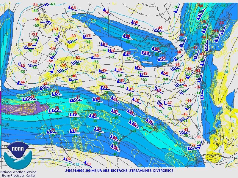 |
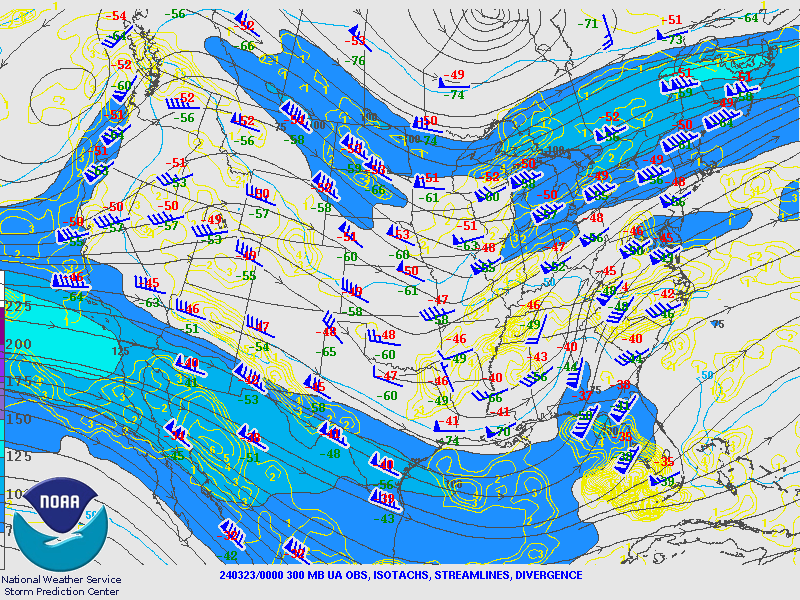
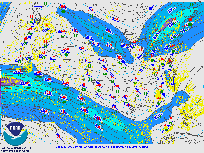
| Figure 1: 300 hPa Chart valid 00 UTC March 22, 2024 | Figure 2: 300 hPa Chart valid 12 UTC March 23, 2024 | Figure 3: 300 hPa Chart valid 00 UTC March 24, 2024 |
500hPa Charts
 |
 |
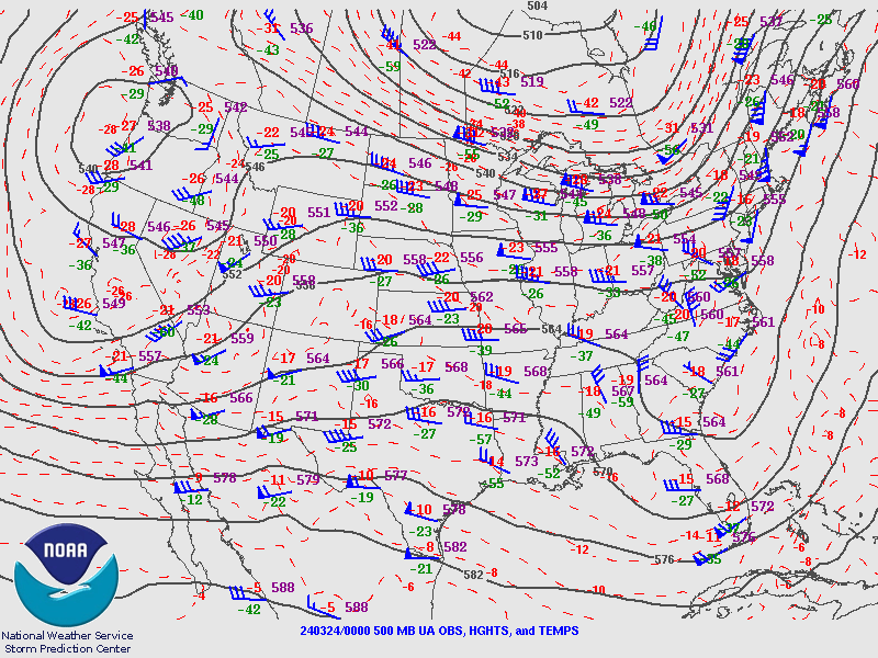 |
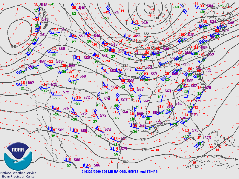
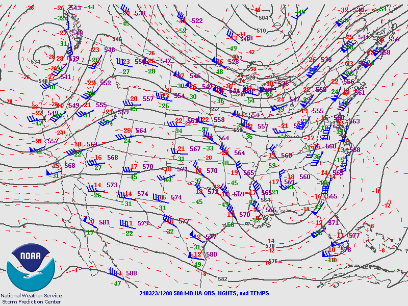
| Figure 1: 500 hPa Chart valid 00 UTC March 22, 2024 | Figure 2: 500 hPa Chart valid 12 UTC March 23, 2024 | Figure 3: 500 hPa Chart valid 00 UTC March 24, 2024 |
850hPa Charts
 |
 |
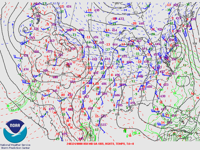 |
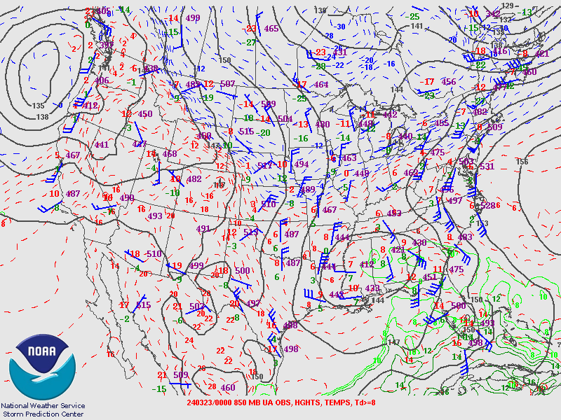
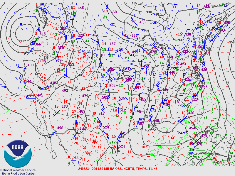
| Figure 7: 850 hPa Chart valid 00 UTC March 22, 2024 | Figure 8: 850 hPa Chart valid 12 UTC March 23, 2024 | Figure 9: 850 hPa Chart valid 00 UTC March 24, 2024 |
Albany Upper Air Soundings
 |
 |
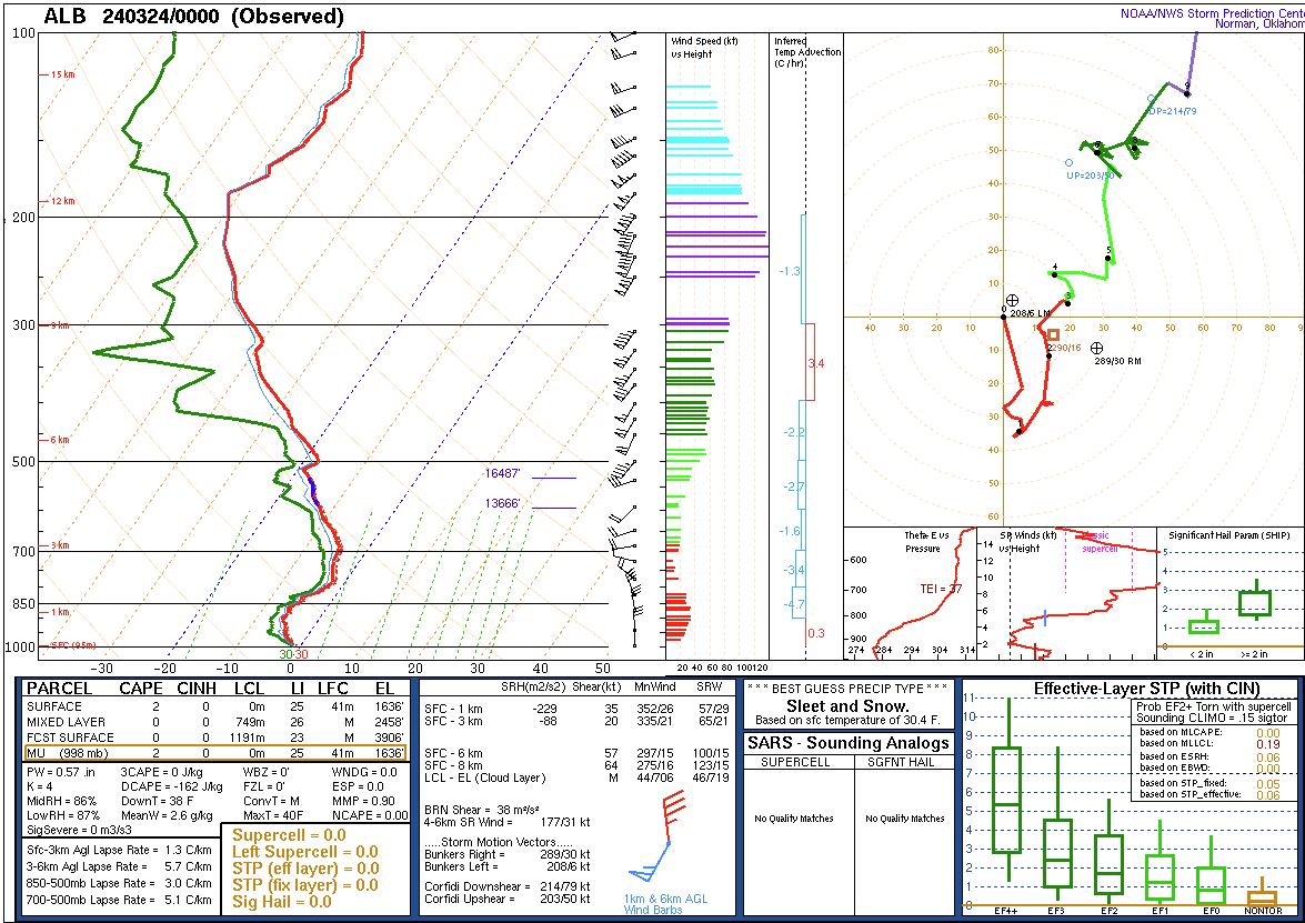 |
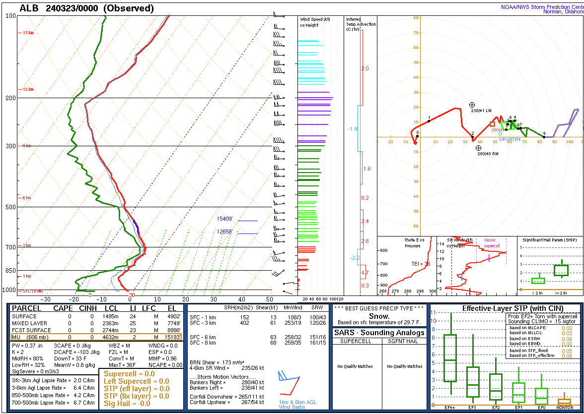
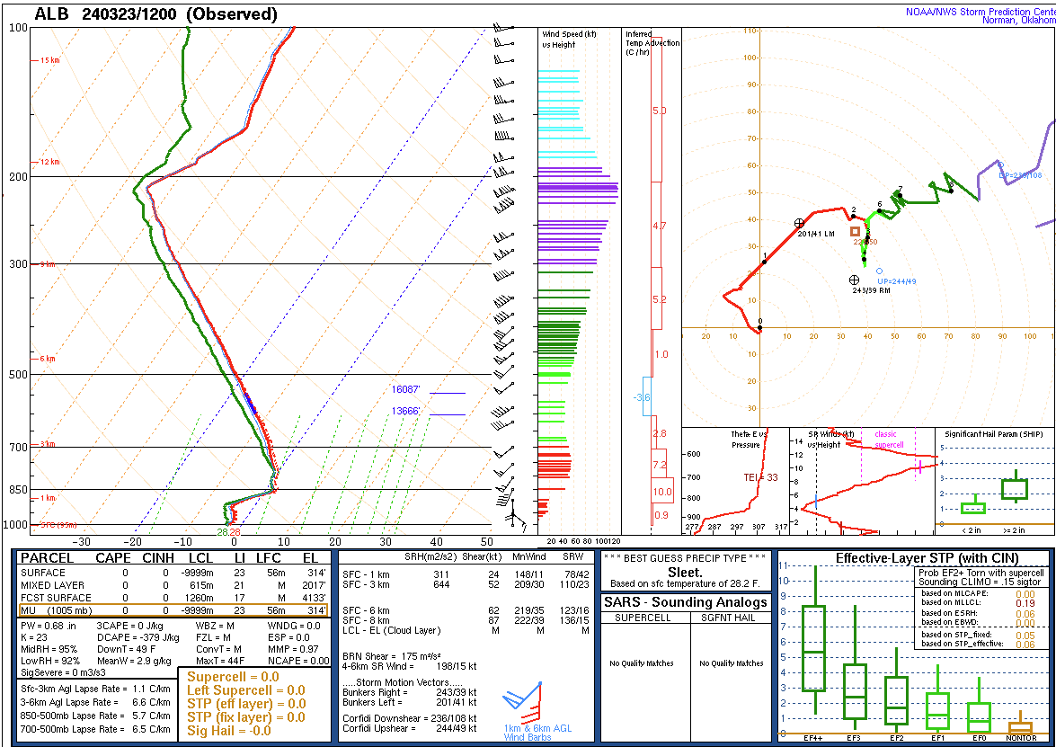
| Figure 4: Albany Sounding 00 UTC March 23, 2024 | Figure 5: Albany Sounding 12 UTC March 23, 2024 | Figure 6: Albany Sounding 00 UTC March 24, 2024 |
 |
Media use of NWS Web News Stories is encouraged! Please acknowledge the NWS as the source of any news information accessed from this site. |
|


