May 18 was the second straight day of widespread 90 degree weather across the Albany forecast area. The hot airmass, despite not being overly humid, provided an unstable environment conducive for thunderstorm development. Thunderstorms began to form in the early afternoon over western New York along a lake breeze boundary. These storms pushed into the Albany forecast area in the mid-afternoon, with the first report of severe weather occurring at 5:38 pm in the Mohawk Valley. The storms were isolated with large hail initially, but a stronger cluster of storms approached from the west after 6 pm. The main hazard with these storms was wind damage as they moved from the Mohawk Valley through the Capital District and into the Lake George Saratoga region by the evening hours. Numerous reports of downed trees and powerlines occurred in this area. The worst damage occurred from Queensbury in Warren County to Kingsbury in Washington County. These storms produced a macroburst, or concentrated area of straight line wind damage. These winds were measured at 68 mph at the Glens Falls New York State Mesonet site, and were estimated to be as high as 90 mph, resulting in widespread tree damage, destroying a barn, and damaging the roofs of a couple of other buildings (see below for more details). Another cluster of storms resulted in wind damage over portions of Dutchess and Litchfield Counties toward midnight.
Public Information Statement (PDF)
Public Information Statement
National Weather Service Albany NY
218 PM EDT Fri May 19 2017

...MACROBURST /STRAIGHT LINE WIND DAMAGE/ CONFIRMED FROM
QUEENSBURY IN WARREN COUNTY TO KINGSBURY IN WASHINGTON COUNTY
NEW YORK...

Location...Queensbury in Warren County across the county line to
Kingsbury in Washington County New York
Date...May 18, 2017
Estimated Time...730-740 PM EDT
Estimated Maximum Wind Speed...90 MPH
Maximum Path Width...1.5 Miles
Path Length...3 Miles
* Fatalities...0
* Injuries...0

* The information in this statement is preliminary and subject to
change pending final review of the event(s) and publication in
NWS Storm Data.

...Summary...
The National Weather Service in Albany NY has confirmed a
macroburst /straight line wind damage/ from Queensbury in
Warren County to Kingsbury in Washington County New York on
May 18, 2017. Confirmation is based on maps and pictures provided
by Washington County Emergency Management, newspaper photos, storm
damage reports from Warren County Emergency Management and trained
spotter reports.

Winds from the macroburst did extensive damage to trees, flattened a
barn and tore part of a roof off a building. Power outages, damage to
homes from falling trees, and road closures were widespread in this
area. Damage started near the Floyd Bennett Memorial Airport. However,
communications to the Automated Surface Observing System /ASOS/ that
provides weather information at the airport were lost. Communications
are still down so no measured wind speeds are available from the airport.

This information can also be found on our website at weather.gov/ALY.

For Reference:
A macroburst is a convective downdraft with an affect outflow
area of at least 2 1/2 miles across and peak winds lasting between
5 and 20 minutes. Intense macrobursts may cause tornado-force
damage of up to EF3 intensity. Straight-line winds are generally
any wind that is not associated with rotation, used mainly to
differentiate them from tornadic winds.
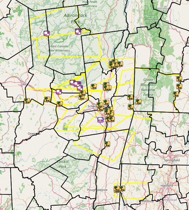
Image courtesy of Iowa Environmental Mesonet (IEM). Yellow boxes are severe thunderstorm warnings.
Local Storm Reports (LSR) are also shown plotted on the map.
PRELIMINARY LOCAL STORM REPORT...SUMMARY
NATIONAL WEATHER SERVICE ALBANY NY
149 PM EDT FRI MAY 19 2017

..TIME...   ...EVENT...      ...CITY LOCATION...     ...LAT.LON...
..DATE...   ....MAG....      ..COUNTY LOCATION..ST.. ...SOURCE....
            ..REMARKS..

0538 PM     HAIL             1 SE KRINGSBUSH         43.00N  74.62W
05/18/2017  M1.50 INCH       MONTGOMERY         NY   PUBLIC

0602 PM     HAIL             BLEECKER                43.12N  74.37W
05/18/2017  M1.00 INCH       FULTON             NY   PUBLIC

0607 PM     HAIL             MAYFIELD                43.10N  74.27W
05/18/2017  M0.88 INCH       FULTON             NY   FACEBOOK

0608 PM     HAIL             1 W VAIL MILLS          43.05N  74.24W
05/18/2017  M1.00 INCH       FULTON             NY   PUBLIC

0618 PM     HAIL             1 NW RICEVILLE          43.10N  74.30W
05/18/2017  M1.25 INCH       FULTON             NY   TRAINED SPOTTER

0623 PM     TSTM WND DMG     WEST WINFIELD           42.88N  75.19W
05/18/2017                   HERKIMER           NY   911 CALL CENTER

            TREES AND WIRES DOWN

0633 PM     HAIL             1 WSW EAGLE BAY         43.76N  74.84W
05/18/2017  M0.88 INCH       HERKIMER           NY   PUBLIC

0641 PM     TSTM WND DMG     VAN HORNESVILLE         42.90N  74.83W
05/18/2017                   HERKIMER           NY   911 CALL CENTER

            TREES AND WIRES DOWN

0702 PM     TSTM WND DMG     AMES                    42.84N  74.60W
05/18/2017                   MONTGOMERY         NY   FACEBOOK

            REPORT OF A TREE... WIRES... AND A TRANSFORMER DOWN

0709 PM     HAIL             INDIAN LAKE             43.79N  74.27W
05/18/2017  M1.50 INCH       HAMILTON           NY   PUBLIC

0711 PM     HAIL             INDIAN LAKE             43.78N  74.27W
05/18/2017  M1.00 INCH       HAMILTON           NY   TRAINED SPOTTER

0730 PM     TSTM WND DMG     QUEENSBURY              43.36N  73.67W
05/18/2017                   WARREN             NY   PUBLIC

            TREES AND POWERLINES DOWN ALONG BAY ROAD

0730 PM     TSTM WND DMG     1 SSE ONEIDA CORNERS    43.35N  73.62W
05/18/2017                   WARREN             NY   TRAINED SPOTTER

            TREES AND WIRES DOWN BLOCKING RIDGE ROAD

0730 PM     TSTM WND DMG     1 NNE ONEIDA CORNERS    43.39N  73.62W
05/18/2017                   WARREN             NY   TRAINED SPOTTER

            TREE DOWN ON CAR

0730 PM     TSTM WND DMG     1 NE QUEENSBURY         43.37N  73.66W
05/18/2017                   WARREN             NY   TRAINED SPOTTER

            TREE DOWN ON HOUSE

0732 PM     TSTM WND DMG     1 WSW SOUTH AMSTERDAM   42.93N  74.21W
05/18/2017                   MONTGOMERY         NY   FACEBOOK

            TREE DOWN BLOCKING ROAD INTERSECTION OF VERBRASKA RD
            AND ROUTE 5S

0735 PM     TSTM WND DMG     1 WNW WALLINS CORNERS   42.98N  74.19W
05/18/2017                   MONTGOMERY         NY   FACEBOOK

            TREE DOWN ON TRAILER

0735 PM     TSTM WND DMG     2 SE ONEIDA CORNERS     43.35N  73.60W
05/18/2017                   WASHINGTON         NY   EMERGENCY MNGR

            LARGE PORTION OF A METAL ROOF BLOWN OFF. TREE UPROOTED
            FLIPPING OVER TWO VEHICLES.

0737 PM     TSTM WND DMG     EAST GALWAY             43.07N  73.99W
05/18/2017                   SARATOGA           NY   TRAINED SPOTTER

            LARGE TREE LIMBS DOWN

0740 PM     TSTM WND DMG     KINGSBURY               43.36N  73.52W
05/18/2017                   WASHINGTON         NY   EMERGENCY MNGR

            ONE BARN DAMAGED AND ONE BARN DESTROYED ON HENDEE RD.
            THE ROOF OF THE BARN WAS BLOWN A QUARTER MILE AWAY.

0740 PM     TSTM WND DMG     2 SSE HAWTHORNE HILL    42.78N  73.87W
05/18/2017                   SCHENECTADY        NY   NEWSPAPER

            TREE DOWN ON HOUSE ON PEARSE RD

0745 PM     TSTM WND DMG     2 NNE SARATOGA SPRINGS  43.09N  73.77W
05/18/2017                   SARATOGA           NY   TWITTER

            LARGE OAK TREE UPROOTED

0745 PM     TSTM WND DMG     EDDY CORNERS            43.05N  73.77W
05/18/2017                   SARATOGA           NY   WNYT

            TREE DOWN ON UNOCCUPIED VAN

0747 PM     TSTM WND DMG     1 N SARATOGA LAKE       43.05N  73.73W
05/18/2017                   SARATOGA           NY   FACEBOOK

            TREES DOWN BETWEEN LAKE LONELY AND SARATOGA LAKE

0752 PM     TSTM WND DMG     SARATOGA SPRINGS        43.07N  73.78W
05/18/2017                   SARATOGA           NY   PUBLIC

            LARGE TREE LIMBS DOWN

0752 PM     TSTM WND DMG     1 ENE FLAGLER CORNERS   42.86N  73.77W
05/18/2017                   SARATOGA           NY   TRAINED SPOTTER

            TREE LIMBS DOWN ON ROUTE 9

0752 PM     TSTM WND DMG     COHOES                  42.77N  73.70W
05/18/2017                   ALBANY             NY   NEWSPAPER

            TREE DOWN ON HOUSE ON MOHAWK ST

0754 PM     TSTM WND DMG     2 NNE SARATOGA SPRINGS  43.09N  73.77W
05/18/2017                   SARATOGA           NY   TRAINED SPOTTER

0756 PM     TSTM WND DMG     1 NNE NISKAYUNA         42.83N  73.89W
05/18/2017                   SCHENECTADY        NY   TWITTER

            TREES AND WIRES DOWN JUST WEST OF BALLTOWN ROAD

0756 PM     TSTM WND DMG     LATHAM                  42.75N  73.75W
05/18/2017                   ALBANY             NY   LAW ENFORCEMENT

            NUMEROUS TREES AND WIRES DOWN. POWER OUTAGES REPORTED.

0757 PM     TSTM WND DMG     1 SSW TROY              42.72N  73.68W
05/18/2017                   RENSSELAER         NY   PUBLIC

            TREE DOWN

0757 PM     TSTM WND DMG     RENSSELAER              42.64N  73.73W
05/18/2017                   RENSSELAER         NY   PUBLIC

            TREES DOWN

0800 PM     TSTM WND DMG     1 SE PARADISE BEACH     43.34N  73.67W
05/18/2017                   WARREN             NY   TRAINED SPOTTER

            WIRES DOWN RESULTING IN STRUCTURE FIRE

0800 PM     TSTM WND DMG     1 S EDDY CORNERS        43.05N  73.77W
05/18/2017                   SARATOGA           NY   AMATEUR RADIO

            MULTIPLE TREES DOWN BLOCKING TWO LANES OF INTERSTATE 87

0800 PM     TSTM WND DMG     1 W SOUTH TROY          42.70N  73.69W
05/18/2017                   RENSSELAER         NY   PUBLIC

            TREES DOWN ON POWER LINES

0800 PM     TSTM WND DMG     2 ESE DEFREESTVILLE     42.64N  73.67W
05/18/2017                   RENSSELAER         NY   NEWSPAPER

            TREES AND WIRES DOWN ACROSS MORNER RD

0813 PM     TSTM WND DMG     2 S NORTH PETERSBURG    42.80N  73.33W
05/18/2017                   RENSSELAER         NY   STORM CHASER

            TREE LIMBS DOWN FROM WIND AND LIGHTNING

0817 PM     TSTM WND DMG     NORTH HOOSICK           42.93N  73.34W
05/18/2017                   RENSSELAER         NY   FIRE DEPT/RESCUE

            MULTIPLE REPORTS OF TREES AND WIRES DOWN

0825 PM     TSTM WND DMG     1 NE NEWTONVILLE        42.73N  73.75W
05/18/2017                   ALBANY             NY   TRAINED SPOTTER

            TREE DOWN

0827 PM     TSTM WND DMG     BENNINGTON              42.87N  73.19W
05/18/2017                   BENNINGTON         VT   LAW ENFORCEMENT

            WIRES DOWN

0903 PM     TSTM WND DMG     2 N BELLOWS FALLS       43.17N  72.46W
05/18/2017                   WINDHAM            VT   LAW ENFORCEMENT

            TREES AND WIRES DOWN ALONG ROUTES 5 AND 91

0905 PM     TSTM WND DMG     1 SW WESTMINSTER        43.07N  72.46W
05/18/2017                   WINDHAM            VT   LAW ENFORCEMENT

            TREES AND WIRES DOWN ALONG ROUTES 5 AND 91

0905 PM     TSTM WND DMG     PUTNEY STATION          42.97N  72.52W
05/18/2017                   WINDHAM            VT   LAW ENFORCEMENT

            TREES AND WIRES DOWN ALONG ROUTES 5 AND 91

0910 PM     TSTM WND DMG     STOCKPORT               42.31N  73.75W
05/18/2017                   COLUMBIA           NY   911 CALL CENTER

            TREES DOWN ON WIRES.

0945 PM     LIGHTNING        SLINGERLANDS            42.63N  73.87W
05/18/2017                   ALBANY             NY   NEWSPAPER

            HOUSE STRUCK BY LIGHTNING AND CAUGHT FIRE

1148 PM     TSTM WND DMG     1 NNE DOVER FURNACE     41.70N  73.58W
05/18/2017                   DUTCHESS           NY   911 CALL CENTER

            NUMEROUS TREES DOWN NEAR ROUTE 22 AND EAST DUNCAN HILL
            ROAD.. TIME ESTIMATED BY RADAR.

1150 PM     TSTM WND DMG     ONIONTOWN               41.72N  73.58W
05/18/2017                   DUTCHESS           NY   EMERGENCY MNGR

            TREE AND WIRES DOWN ON OLD ROUTE 22

1155 PM     TSTM WND DMG     KENT                    41.72N  73.48W
05/18/2017                   LITCHFIELD         CT   911 CALL CENTER

            SEVERAL TREES DOWN

