Overview
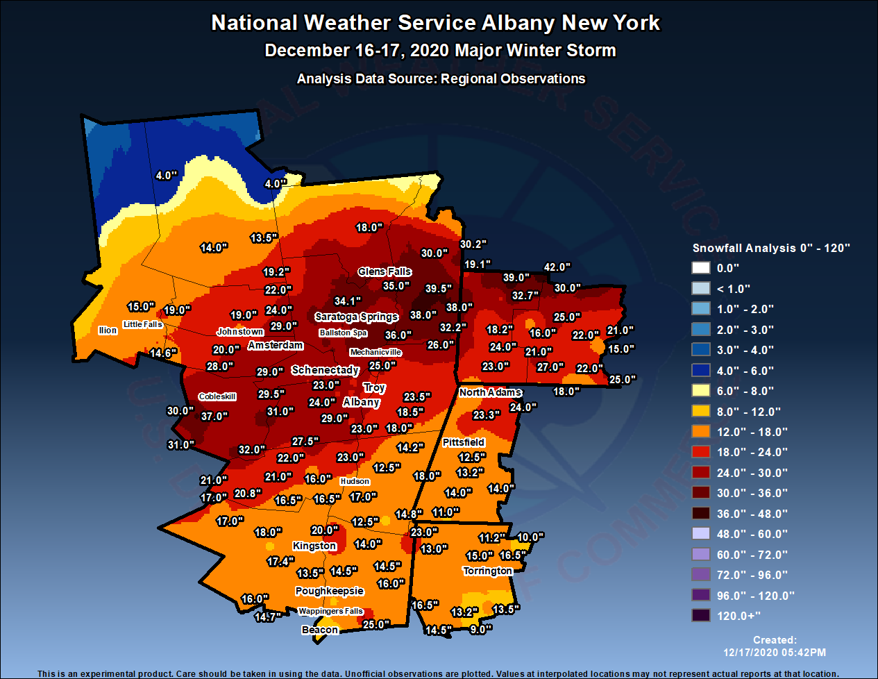
Low pressure moved northward from the Outer Banks of North Carolina to just south of Long Island from Wednesday, December 16th into the early morning hours on Thursday, December 17th. Copious moisture was lifted over a dome of cold air over the Northeastern US, allowing snow to spread into eastern New York and western New England during the afternoon and evening hours of the 16th. Heavy snow bands of 1- 2" per hour were common with this initial activity. The heavy snow bands slowed their northward progress and pivoted, resulting in incredible snowfall rates of up to 6" per hour after midnight on the 17th through the late morning. A swath of very heavy snow occurred where these bands pivoted across Schoharie, Schenectady, Saratoga, southeast Warren, Washington, and northern Bennington Counties. Snowfall amounts of 2-3 feet were common in these areas before the snow finally ended in the late morning/early afternoon of the 17th. Elsewhere in the region, snow amounts of 1-2 feet were common aside from the southern Adirondacks which were on the periphery of the storm. Officially, 22.9" was measured at Albany International Airport, making this storm the 8th largest snowstorm on record at Albany at the time, and the 4th largest in December.Snow
 |
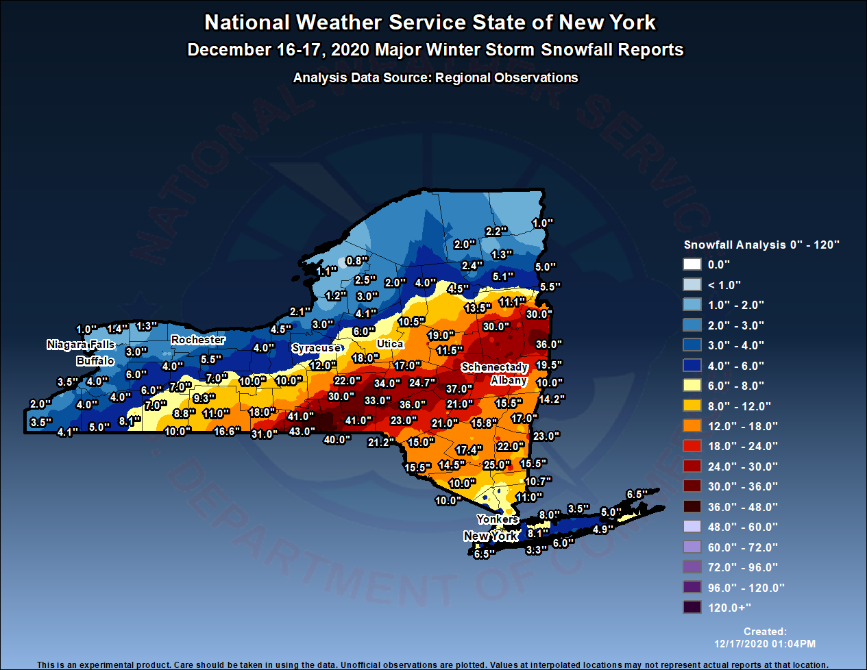 |
| Albany CWA observed snowfall map | New York State observed snowfall map |
PUBLIC INFORMATION STATEMENT
SPOTTER REPORTS
NATIONAL WEATHER SERVICE ALBANY NY
514 PM EST THU DEC 17 2020

THE FOLLOWING ARE UNOFFICIAL OBSERVATIONS TAKEN DURING THE PAST 11
HOURS FOR THE STORM THAT HAS BEEN AFFECTING OUR REGION. APPRECIATION
IS EXTENDED TO HIGHWAY DEPARTMENTS, COOPERATIVE OBSERVERS, SKYWARN
SPOTTERS AND MEDIA FOR THESE REPORTS. THIS SUMMARY ALSO IS AVAILABLE
ON OUR HOME PAGE AT WEATHER.GOV/ALBANY

********************STORM TOTAL SNOWFALL********************

LOCATION                TOTAL      TIME/DATE  COMMENTS
                     SNOWFALL       MEASURED
                     (INCHES)

CONNECTICUT

...LITCHFIELD COUNTY...
  NEW MILFORD            16.5   930 AM 12/17  SOCIAL MEDIA
  1 SE WINSTED           16.5  1100 AM 12/17  TRAINED SPOTTER
  CANAAN                 16.0   245 PM 12/17  WEATHERNET6
  TORRINGTON             15.0   900 AM 12/17  FACEBOOK
  3 SSE ROXBURY          14.5  1235 PM 12/17  TRAINED SPOTTER
  WATERTOWN              13.5   100 PM 12/17  TRAINED SPOTTER
  ROXBURY                13.2   625 AM 12/17  SOCIAL MEDIA
  FALLS VILLAGE          13.0   200 PM 12/17  TRAINED SPOTTER
  HARWINTON              12.0   800 AM 12/17  TRAINED SPOTTER
  WINSTED                11.2   900 AM 12/17  AMATEUR RADIO
  BARKHAMSTEAD           10.0   112 PM 12/17  TRAINED SPOTTER
  WOODBURY CENTER         9.0   930 AM 12/17  AMATEUR RADIO

MASSACHUSETTS

...BERKSHIRE COUNTY...
  FLORIDA                24.0   459 PM 12/17  BROADCAST MEDIA
  SAVOY                  23.3   441 PM 12/17  WEATHERNET6
  LANESBOROUGH           23.0   442 PM 12/17  WEATHERNET6
  PITTSFIELD             14.5   434 PM 12/17  WEATHERNET6
  BECKET                 14.0   456 PM 12/17  WEATHERNET6
  GREAT BARRINGTON       14.0   106 PM 12/17  FACEBOOK
  WILLIAMSTOWN           14.0  1015 AM 12/17  SOCIAL MEDIA
  LENOXDALE              13.2   335 PM 12/17  1.20" OF LIQUID
  LENOX                  12.5  1215 PM 12/17  TRAINED SPOTTER
  2 SE PITTSFIELD        11.0   810 AM 12/17  TRAINED SPOTTER
  ASHLEY FALLS           11.0   248 PM 12/17  TRAINED SPOTTER

NEW YORK

...ALBANY COUNTY...
  KNOX                   29.5  1218 PM 12/17  WEATHERNET6
  DELMAR                 29.0   458 PM 12/17  WEATHERNET6
  COLONIE                28.0   900 AM 12/17  TWITTER
  1 W ALBANY             27.1   715 AM 12/17  TRAINED SPOTTER
  2 SE DELMAR            26.5   129 PM 12/17  METEOROLOGIST
  LATHAM                 26.1  1259 PM 12/17  FACEBOOK
  2 N DELMAR             26.0   200 PM 12/17  TRAINED SPOTTER
  ALBANY                 25.2   100 PM 12/17  NWS ALBANY OFFICE
  2 W ALBANY             24.8   149 PM 12/17  RETIRED NWS EMP.
  BOGHT CORNERS          24.5  1135 AM 12/17  NWS EMPLOYEE
  GUILDERLAND            24.0   845 AM 12/17  TRAINED SPOTTER
  COHOES                 24.0  1148 AM 12/17  WEATHERNET6
  WESTMERE               23.5  1138 AM 12/17  SOCIAL MEDIA
  2 N SELKIRK            23.0  1130 AM 12/17  NWS EMPLOYEE
  3 NW GUILDERLAND       23.0  1040 AM 12/17  NWS EMPLOYEE
  ALBANY INTL AP         22.9   100 PM 12/17  STORM TOTAL
  2 SSE COLONIE          22.0   925 AM 12/17  TRAINED SPOTTER
  2 E ALBANY             22.0  1108 AM 12/17  SOCIAL MEDIA
  WATERVLIET             22.0   226 PM 12/17  SOCIAL MEDIA
  1 WNW ALBANY           21.2  1205 PM 12/17  NWS EMPLOYEE

...COLUMBIA COUNTY...
  SPENCERTOWN            18.0   459 PM 12/17  WEATHERNET6
  LIVINGSTON             17.0   814 AM 12/17  WEATHERNET6
  GERMANTOWN             16.5   422 PM 12/17  WEATHERNET6
  CLERMONT               15.5   205 PM 12/17  TRAINED SPOTTER
  ANCRAMDALE             14.8   458 PM 12/17  WEATHERNET6
  CANAAN                 14.2   925 AM 12/17  TRAINED SPOTTER
  3 N AUSTERLITZ         13.5   800 AM 12/17  TRAINED SPOTTER
  TAGHKANIC              12.5   800 AM 12/17  WEATHERNET6
  CHATHAM                12.5  1253 PM 12/17  15" DRIFTS
  ANCRAM                 10.0   830 AM 12/17  TRAINED SPOTTER

...DUTCHESS COUNTY...
  3 ESE HOPEWELL JUNCT   25.0  1000 AM 12/17  SOCIAL MEDIA
  MILLERTON              23.0  1021 AM 12/17  SOCIAL MEDIA
  RHINEBECK              22.0   839 AM 12/17  SOCIAL MEDIA
  RED HOOK               20.0   100 PM 12/17  TRAINED SPOTTER
  5 ENE LAGRANGE         16.0  1030 AM 12/17  TRAINED SPOTTER
  LAGRANGE               16.0   232 PM 12/17  PUBLIC
  POUGHKEEPSIE           15.0  1040 AM 12/17  SOCIAL MEDIA
  HYDE PARK              14.5  1130 AM 12/17  TRAINED SPOTTER
  MILLBROOK              14.5  1253 PM 12/17  COCORAHS
  PINE PLAINS            14.0   843 AM 12/17  WEATHERNET6
  4 SE ELIZAVILLE        14.0   720 AM 12/17  TRAINED SPOTTER
  HOPEWELL JUNCTION      12.8  1140 AM 12/17  TRAINED SPOTTER
  1 WSW RED OAKS MILL    11.1   835 AM 12/17  TRAINED SPOTTER
  BEACON                 10.8  1034 AM 12/17  TWITTER

...FULTON COUNTY...
  PERTH                  29.0   454 PM 12/17  WEATHERNET6
  BROADALBIN             24.0  1002 AM 12/17  WEATHERNET6
  NORTHVILLE             19.2  1035 AM 12/17  WEATHERNET6
  MAYFIELD               19.0   105 PM 12/17  FACEBOOK
  JOHNSTOWN              16.0  1007 AM 12/17  WEATHERNET6

...GREENE COUNTY...
  GREENVILLE CENTER      27.5  1229 PM 12/17  WEATHERNET6
  EARLTON                23.0   106 PM 12/17  FACEBOOK
  FREEHOLD               22.0  1045 AM 12/17  TRAINED SPOTTER
  HALCOTT CENTER         21.0   423 PM 12/17  WEATHERNET6
  EAST JEWETT            21.0   925 AM 12/17  TRAINED SPOTTER
  WEST KILL              20.8   630 AM 12/17  WEATHERNET6
  HAINES FALLS           16.5   655 AM 12/17  WEATHERNET6
  TANNERSVILLE           16.5   700 AM 12/17  AMATEUR RADIO
  CAIRO                  16.0  1134 AM 12/17  WEATHERNET6
  CATSKILL               15.8  1132 AM 12/17  WEATHERNET6

...HAMILTON COUNTY...
  PISECO                 14.0   421 PM 12/17  WEATHERNET6
  WELLS                  13.5   814 AM 12/17  WEATHERNET6
  INDIAN LAKE             4.0   709 AM 12/17  WEATHERNET6
  INLET                   4.0   730 AM 12/17  TRAINED SPOTTER

...HERKIMER COUNTY...
  DOLGEVILLE             19.0   800 AM 12/17  TRAINED SPOTTER
  MOHAWK                 19.0   100 PM 12/17  FACEBOOK
  2 NW DOLGEVILLE        15.0   740 AM 12/17  COCORAHS
  ILION                  13.0   724 AM 12/17  FACEBOOK

...MONTGOMERY COUNTY...
  AMSTERDAM              31.0  1216 PM 12/17  TRAINED SPOTTER
  1 E AMSTERDAM          31.0   225 PM 12/17  TRAINED SPOTTER
  GLEN                   28.0   429 PM 12/17  WEATHERNET6
  2 NW PATTERSONVILLE    27.0   806 AM 12/17  SOCIAL MEDIA
  TRIBES HILL            25.0  1126 AM 12/17  SOCIAL MEDIA
  FONDA                  22.0   456 PM 12/17  WEATHERNET6
  PALATINE BRIDGE        20.0   449 PM 12/17  WEATHERNET6
  HESSVILLE              14.6  1222 PM 12/17  WEATHERNET6

...RENSSELAER COUNTY...
  HAMPTON MANOR          26.0  1042 AM 12/17  SOCIAL MEDIA
  3 SSW EAGLE BRIDGE     26.0   100 PM 12/17  FACEBOOK
  SPEIGLETOWN            25.0   426 PM 12/17  WEATHERNET6
  1 S WATERFORD          24.0  1030 AM 12/17  FACEBOOK
  POESTENKILL            23.5   100 PM 12/17  FACEBOOK
  EAST GREENBUSH         22.0   200 PM 12/17  FIRE DEPT/RESCUE
  TROY                   21.0   930 AM 12/17  TWITTER
  1 WNW AVERILL PARK     20.6  1216 PM 12/17  METEOROLOGIST
  1 E WEST SAND LAKE     20.5  1130 AM 12/17  TRAINED SPOTTER
  CENTER BRUNSWICK       20.0   459 PM 12/17  WEATHERNET6
  BERLIN                 20.0   400 PM 12/17  FACEBOOK
  3 S WEST SAND LAKE     18.5   900 AM 12/17  TRAINED SPOTTER
  1 ENE WEST SAND LAKE   18.0   715 AM 12/17  TRAINED SPOTTER
  EAST SCHODACK          18.0   931 AM 12/17  TRAINED SPOTTER
  1 N SYCAWAY            17.3   830 AM 12/17  1.75 INCHES LIQUID

...SARATOGA COUNTY...
  2 N THE SARATOGA BAT   36.0  1230 PM 12/17  TRAINED SPOTTER
  GANSEVOORT             35.0   221 PM 12/17  SOCIAL MEDIA
  SARATOGA SPRINGS       35.0   230 PM 12/17  TRAINED SPOTTER
  2 ESE PROVIDENCE       34.5   250 PM 12/17  TRAINED SPOTTER
  WILTON                 34.1   157 PM 12/17  TRAINED SPOTTER
  ROUND LAKE             34.0   100 PM 12/17  RETIRED NWS EMP.
  2 NNE ROUND LAKE       33.8   213 PM 12/17  COCORAHS
  2 NE SARATOGA LAKE     33.0  1054 AM 12/17  METEOROLOGIST
  2 NNE ROCK CITY FALL   32.0  1057 AM 12/17  SOCIAL MEDIA
  BURNT HILLS            31.5   130 PM 12/17  TRAINED SPOTTER
  MILTON                 31.0  1000 AM 12/17  SOCIAL MEDIA
  BALLSTON SPA           31.0   100 PM 12/17  PUBLIC
  CHARLTON               31.0   455 PM 12/17  WEATHERNET6
  2 S CLIFTON PARK CEN   30.1  1015 AM 12/17  RETIRED NWS EMP.
  CORINTH                30.0  1145 AM 12/17  WEATHERNET6
  MALTA                  30.0   931 AM 12/17  TRAINED SPOTTER
  LAKE DESOLATION        29.5   434 PM 12/17  WEATHERNET6
  GALWAY                 29.0   451 PM 12/17  WEATHERNET6
  CLIFTON PARK           29.0   800 AM 12/17  SOCIAL MEDIA
  2 S GANSEVOORT         27.5  1135 AM 12/17  FACEBOOK
  HICKEYS CORNERS        27.0   700 AM 12/17  RETIRED NWS EMP.
  MOREAU                 26.5  1144 AM 12/17  TWITTER
  SCHUYLERVILLE          26.4   725 AM 12/17  TRAINED SPOTTER
  PROVIDENCE             25.5   830 AM 12/17  SOCIAL MEDIA
  SOUTH GLENS FALLS      25.0   800 AM 12/17  BROADCAST MEDIA
  BALLSTON LAKE          24.0   725 AM 12/17  WEATHERNET6
  EDINBURG               22.0  1115 AM 12/17  TRAINED SPOTTER
  FACTORY VILLAGE        20.5   658 AM 12/17  NWS EMPLOYEE

...SCHENECTADY COUNTY...
  SOUTH SCHENECTADY      31.1  1200 PM 12/17  NWS EMPLOYEE
  2 WNW ROTTERDAM        30.6   132 PM 12/17  FACEBOOK
  ROTTERDAM              30.6   900 AM 12/17  TRAINED SPOTTER
  1 NNW NISKAYUNA        30.2  1025 AM 12/17  NWS EMPLOYEE
  1 SSW AQUEDUCT         30.0  1120 AM 12/17  NWS EMPLOYEE
  SCHENECTADY-GE PLOT    29.7  1120 AM 12/17  NWS EMPLOYEE
  SCHENECTADY            29.5   140 PM 12/17  WEATHERNET6
  1 N DELANSON           29.0   800 AM 12/17  SOCIAL MEDIA
  EAST GLENVILLE         29.0   800 AM 12/17  SOCIAL MEDIA
  GLENVILLE              29.0   319 PM 12/17  WEATHERNET6
  DELANSON               29.0  1219 PM 12/17  WEATHERNET6
  2 NNW EAST GLENVILLE   28.5   115 PM 12/17  METEOROLOGIST
  SCOTIA                 28.0   800 AM 12/17  SOCIAL MEDIA
  1 NNE HAWTHORNE HILL   26.5   159 PM 12/17  NWS EMPLOYEE
  3 SE PRINCETOWN        23.7   615 AM 12/17  TRAINED SPOTTER
  NISKAYUNA              23.5   627 AM 12/17  ESTIMATED BY PICTURE

...SCHOHARIE COUNTY...
  SUMMIT                 37.0  1131 AM 12/17  SOCIAL MEDIA
  GILBOA                 32.0   120 PM 12/17  FACEBOOK
  JEFFERSON              31.0   451 PM 12/17  WEATHERNET6
  MIDDLEBURGH            31.0   456 PM 12/17  WEATHERNET6
  RICHMONDVILLE          30.0   443 PM 12/17  WEATHERNET6
  CHARLOTTEVILLE         30.0   438 PM 12/17  WEATHERNET6
  WARNERVILLE            26.5   458 PM 12/17  WEATHERNET6
  NORTH BLENHEIM         25.0   825 AM 12/17  TRAINED SPOTTER

...ULSTER COUNTY...
  OLIVEBRIDGE            18.0  1159 AM 12/17  WEATHERNET6
  1 E LOMONTVILLE        17.4  1025 AM 12/17  TRAINED SPOTTER
  PHOENICIA              17.0   647 AM 12/17  WEATHERNET6
  4 SSE HALCOTT CENTER   17.0  1224 PM 12/17  TRAINED SPOTTER
  1 W LOMONTVILLE        16.2   700 AM 12/17  AMATEUR RADIO
  ELLENVILLE             16.0   759 AM 12/17  SOCIAL MEDIA
  2 SE WOODSTOCK         16.0   700 AM 12/17  AMATEUR RADIO
  PORT EWEN              15.0   700 AM 12/17  AMATEUR RADIO
  WALLKILL               14.7  1135 AM 12/17  STORM CHASER
  PLATTEKILL             14.0  1030 AM 12/17  TRAINED SPOTTER
  ESOPUS                 14.0  1110 AM 12/17  1.67" LIQUID
  HIGHLAND               13.5   700 AM 12/17  AMATEUR RADIO
  NEW PALTZ              13.5   700 AM 12/17  AMATEUR RADIO
  1 ENE OLIVE             9.5   700 AM 12/17  AMATEUR RADIO

...WARREN COUNTY...
  GLENS FALLS            33.8  1200 PM 12/17  BROADCAST MEDIA
  QUEENSBURY             33.0   453 PM 12/17  WEATHERNET6
  1 NW WEST GLENS FALL   27.0   830 AM 12/17  TRAINED SPOTTER
  WARRENSBURG            18.0   444 PM 12/17  WEATHERNET6

...WASHINGTON COUNTY...
  COSSAYUNA              39.5   312 PM 12/17  WEATHERNET6
  SALAM                  38.0   422 PM 12/17  WEATHERNET6
  GREENWICH              38.0  1215 PM 12/17  WEATHERNET6
  SALEM                  35.0   900 AM 12/17  SOCIAL MEDIA
  CAMBRIDGE              32.2  1000 AM 12/17  TRAINED SPOTTER
  ARGYLE                 31.0   953 AM 12/17  EMERGENCY MANAGER
  GRANVILLE              30.2   227 PM 12/17  EMERGENCY MANAGER
  HARTFORD               30.0  1144 AM 12/17  WEATHERNET6

VERMONT

...BENNINGTON COUNTY...
  LANDGROVE              42.0   414 PM 12/17  WEATHERNET6
  EAST DORSET            39.0  1200 PM 12/17  PUBLIC
  MANCHESTER CENTER      32.7   419 PM 12/17  WEATHERNET6
  WOODFORD               24.0  1058 AM 12/17  WEATHERNET6
  1 NE MANCHESTER        23.1   200 PM 12/17  TRAINED SPOTTER
  5 NW READSBORO         23.0  1215 PM 12/17  TWITTER
  SEARSBURG              21.0   800 AM 12/17  TRAINED SPOTTER
  3 ENE HEBRON           19.1   800 AM 12/17  TRAINED SPOTTER
  1 ESE ARLINGTON        18.2   902 AM 12/17  PUBLIC

...WINDHAM COUNTY...
  LONDONDERRY            30.0  1200 PM 12/17  PUBLIC
  WILMINGTON             27.0  1240 PM 12/17  FACEBOOK
  3 ENE WEST WARDSBORO   25.0   102 PM 12/17  FACEBOOK
  VERNON                 25.0   200 PM 12/17  PUBLIC
  BRATTLEBORO            22.0   400 PM 12/17  FACEBOOK
  1 SSE TOWNSHEND        22.0  1200 PM 12/17  TRAINED SPOTTER
  1 NE PUTNEY            21.0  1200 PM 12/17  COCORAHS
  3 SSW HALIFAX          18.0  1245 PM 12/17  TWITTER
  STRATTON               16.0   730 AM 12/17  BROADCAST MEDIA
  3 SSW PUTNEY           15.0  1245 PM 12/17  TRAINED SPOTTER


**********************24 HOUR SNOWFALL**********************

LOCATION              24 HOUR      TIME/DATE  COMMENTS
                     SNOWFALL       MEASURED
                     (INCHES)

CONNECTICUT

...LITCHFIELD COUNTY...
  3 SW NEW HARTFORD CE   12.0   700 AM 12/17  COCORAHS
  BAKERSVILLE            12.0   700 AM 12/17  CO-OP OBSERVER
  2 WNW WARREN           11.0   700 AM 12/17  COCORAHS
  4 NE SALISBURY         11.0   700 AM 12/17  COCORAHS
  3 WNW NEW MILFORD      10.7   700 AM 12/17  COCORAHS
  4 ESE WINSTED          10.4   700 AM 12/17  COCORAHS
  2 W NEW MILFORD        10.2   735 AM 12/17  COCORAHS
  5 SSW NEW MILFORD       9.5   800 AM 12/17  COCORAHS
  1 S WATERTOWN           8.5   720 AM 12/17  COCORAHS
  2 NNE LITCHFIELD        6.0   900 AM 12/17  COCORAHS
  2 S HARWINTON           5.3   800 AM 12/17  COCORAHS

MASSACHUSETTS

...BERKSHIRE COUNTY...
  1 NNW CHESHIRE         16.7   700 AM 12/17  COCORAHS
  3 N GREAT BARRINGTON   13.0   800 AM 12/17  COCORAHS
  2 NW SHEFFIELD         10.0   700 AM 12/17  COCORAHS
  4 SE LEE                9.5   700 AM 12/17  COCORAHS

NEW YORK

...ALBANY COUNTY...
  3 SW ALTAMONT          27.1   700 AM 12/17  COCORAHS
  2 NNW RENSSELAERVILL   23.0   700 AM 12/17  COCORAHS
  3 SSW ALTAMONT         21.4   655 AM 12/17  COCORAHS
  2 W ALBANY             21.0   815 AM 12/17  COCORAHS
  NWS ALBANY             19.0   700 AM 12/17  COCORAHS
  1 SW ALBANY            18.8   700 AM 12/17  COCORAHS
  3 SW GLENMONT          18.0   700 AM 12/17  COCORAHS
  1 S DELMAR             15.4   700 AM 12/17  COCORAHS

...COLUMBIA COUNTY...
  1 SSW LIVINGSTON       17.0   755 AM 12/17  COCORAHS
  3 N VALATIE            14.2   700 AM 12/17  COCORAHS
  N ANCRAMDALE           11.5   700 AM 12/17  COCORAHS

...DUTCHESS COUNTY...
  2 S POUGHQUAG          15.5   700 AM 12/17  COCORAHS
  1 NNE RED HOOK         13.5   700 AM 12/17  COCORAHS
  3 N RHINEBECK          12.5   700 AM 12/17  COCORAHS
  3 NE LAGRANGEVILLE     11.0   700 AM 12/17  COCORAHS
  3 SE MILLBROOK          9.8   700 AM 12/17  COCORAHS

...FULTON COUNTY...
  5 ESE BROADALBIN       26.0   900 AM 12/17  COCORAHS
  GLOVERSVILLE 7NW       11.5   700 AM 12/17  CO-OP OBSERVER

...GREENE COUNTY...
  2 N LEXINGTON          22.0   700 AM 12/17  COCORAHS
  1 E GREENVILLE         17.0   700 AM 12/17  COCORAHS
  SE NEW BALTIMORE       17.0   800 AM 12/17  COCORAHS
  3 E FREEHOLD           15.5   710 AM 12/17  COCORAHS

...HAMILTON COUNTY...
  10 SSW SPECULATOR      12.0   700 AM 12/17  COCORAHS
  2 WSW LAKE PLEASANT    11.0   655 AM 12/17  COCORAHS
  2 WNW HOFFMEISTER      10.5   800 AM 12/17  COCORAHS
  INDIAN LAKE             4.5   755 AM 12/17  CO-OP OBSERVER
  SSE LONG LAKE           2.0   700 AM 12/17  COCORAHS

...HERKIMER COUNTY...
  1 WSW ILION            15.0   700 AM 12/17  COCORAHS

...MONTGOMERY COUNTY...
  1 NNW AMSTERDAM        30.0  1157 AM 12/17  COCORAHS
  WSW ST. JOHNSVILLE     16.8   800 AM 12/17  COCORAHS
  2 WSW HESSVILLE        13.8   800 AM 12/17  COCORAHS
  SE FORT PLAIN          12.7   700 AM 12/17  COCORAHS

...RENSSELAER COUNTY...
  BUSKIRK                19.5   700 AM 12/17  CO-OP OBSERVER
  1 E TROY               18.8   700 AM 12/17  COCORAHS
  3 NE TROY              18.0   700 AM 12/17  COCORAHS
  1 WNW AVERILL PARK     18.0   800 AM 12/17  COCORAHS
  2 NNE TROY             17.3   830 AM 12/17  COCORAHS
  7 NE TROY              17.2   700 AM 12/17  COCORAHS
  4 ESE NASSAU           13.7   830 AM 12/17  COCORAHS
  3 SW STEPHENTOWN       10.0   700 AM 12/17  COCORAHS

...SARATOGA COUNTY...
  4 NE ROUND LAKE        31.5   800 AM 12/17  COCORAHS
  2 NNE ROUND LAKE       30.6   748 AM 12/17  COCORAHS
  2 SSW SCHUYLERVILLE    26.4   700 AM 12/17  COCORAHS
  1 S SARATOGA SPRINGS   24.3   700 AM 12/17  COCORAHS
  3 WSW MECHANICVILLE    21.0   841 AM 12/17  COCORAHS

...SCHENECTADY COUNTY...
  1 NW ROTTERDAM         30.5   830 AM 12/17  COCORAHS
  DELANSON 2NE           15.0   700 AM 12/17  CO-OP OBSERVER

...SCHOHARIE COUNTY...
  COBLESKILL             24.0   935 AM 12/17  CO-OP OBSERVER

...ULSTER COUNTY...
  PHOENICIA              17.0   652 AM 12/17  CO-OP OBSERVER
  2 S HURLEY             15.8   700 AM 12/17  COCORAHS
  4 E WALLKILL           14.2   700 AM 12/17  COCORAHS
  1 NNW ULSTER PARK      14.0   730 AM 12/17  COCORAHS
  SW HIGHLAND            13.5   700 AM 12/17  COCORAHS
  2 WNW ROSENDALE VILL   12.5   740 AM 12/17  COCORAHS
  1 ENE WOODSTOCK        12.0   700 AM 12/17  COCORAHS
  1 WNW GARDINER         10.0   800 AM 12/17  COCORAHS

...WARREN COUNTY...
  2 WNW WARRENSBURG      11.1   800 AM 12/17  COCORAHS

VERMONT

...BENNINGTON COUNTY...
  1 NNE LANDGROVE        30.0   800 AM 12/17  COCORAHS
  PERU                   29.6   700 AM 12/17  CO-OP OBSERVER
  3 ENE MANCHESTER       20.5   700 AM 12/17  COCORAHS
  WNW SHAFTSBURY         16.5   722 AM 12/17  COCORAHS

...WINDHAM COUNTY...
  1 WNW WILMINGTON       19.0   920 AM 12/17  COCORAHS
  6 W WEST BRATTLEBORO   17.8   900 AM 12/17  CO-OP OBSERVER
  2 NNE MARLBORO         17.8   900 AM 12/17  COCORAHS
  1 NNE ROCKINGHAM       17.2   800 AM 12/17  COCORAHS
  2 WNW PUTNEY           15.0   820 AM 12/17  COCORAHS
  6 NW WESTMINSTER       13.0   700 AM 12/17  COCORAHS
  SE WEST HALIFAX        12.0   818 AM 12/17  COCORAHS
  1 S BRATTLEBORO        10.6   700 AM 12/17  COCORAHS

&&
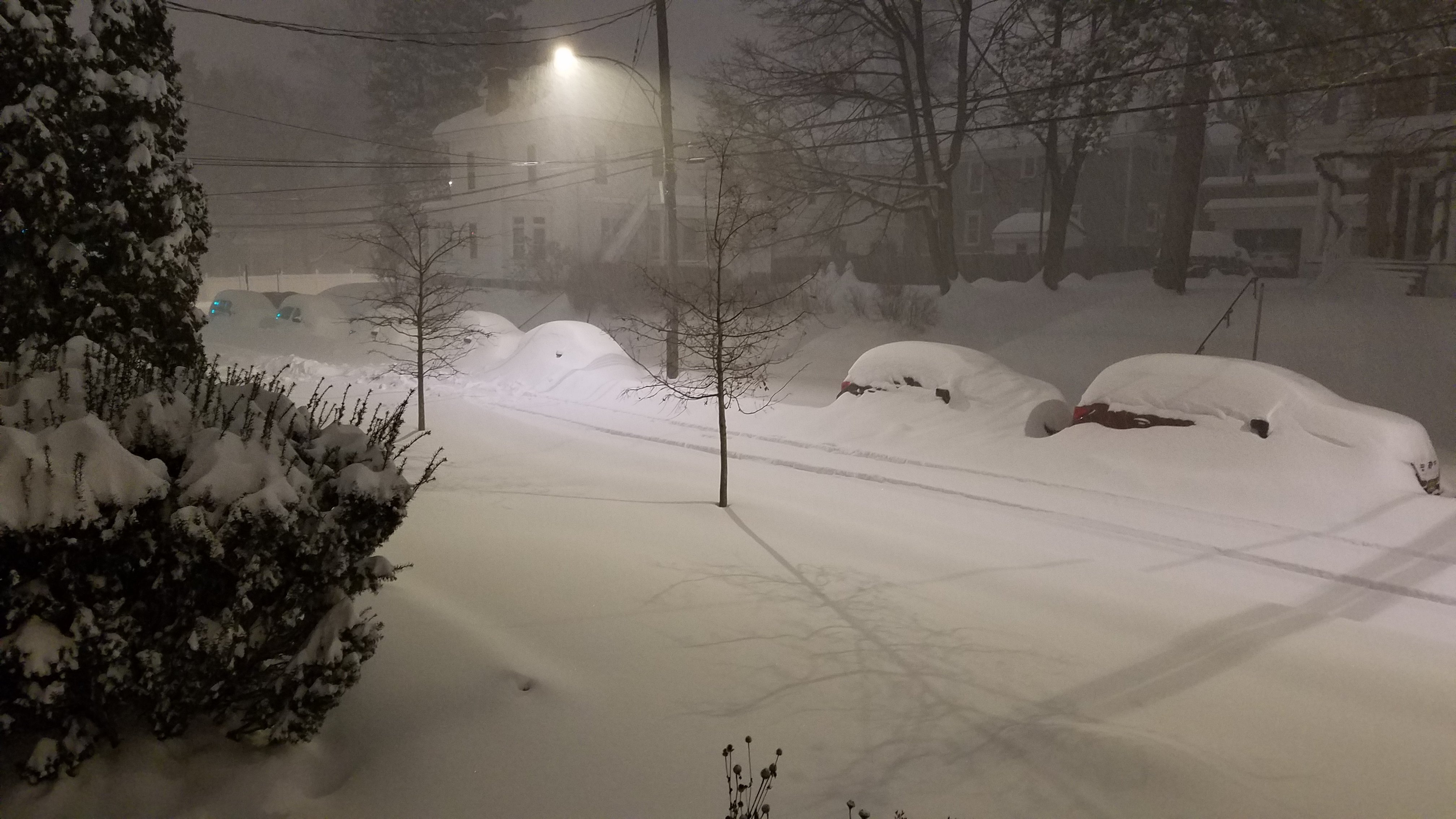
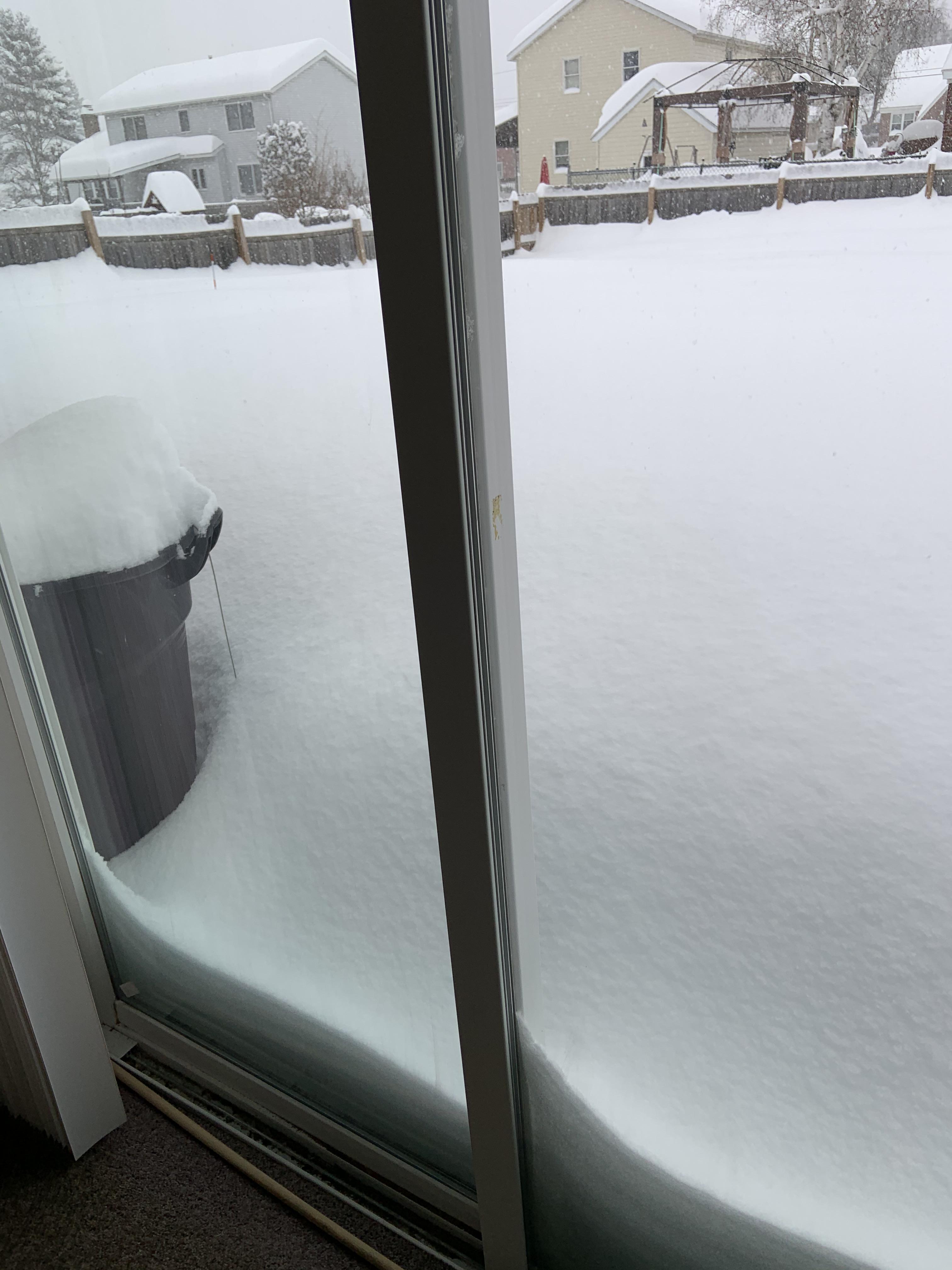
Photos & Video
 |
 |
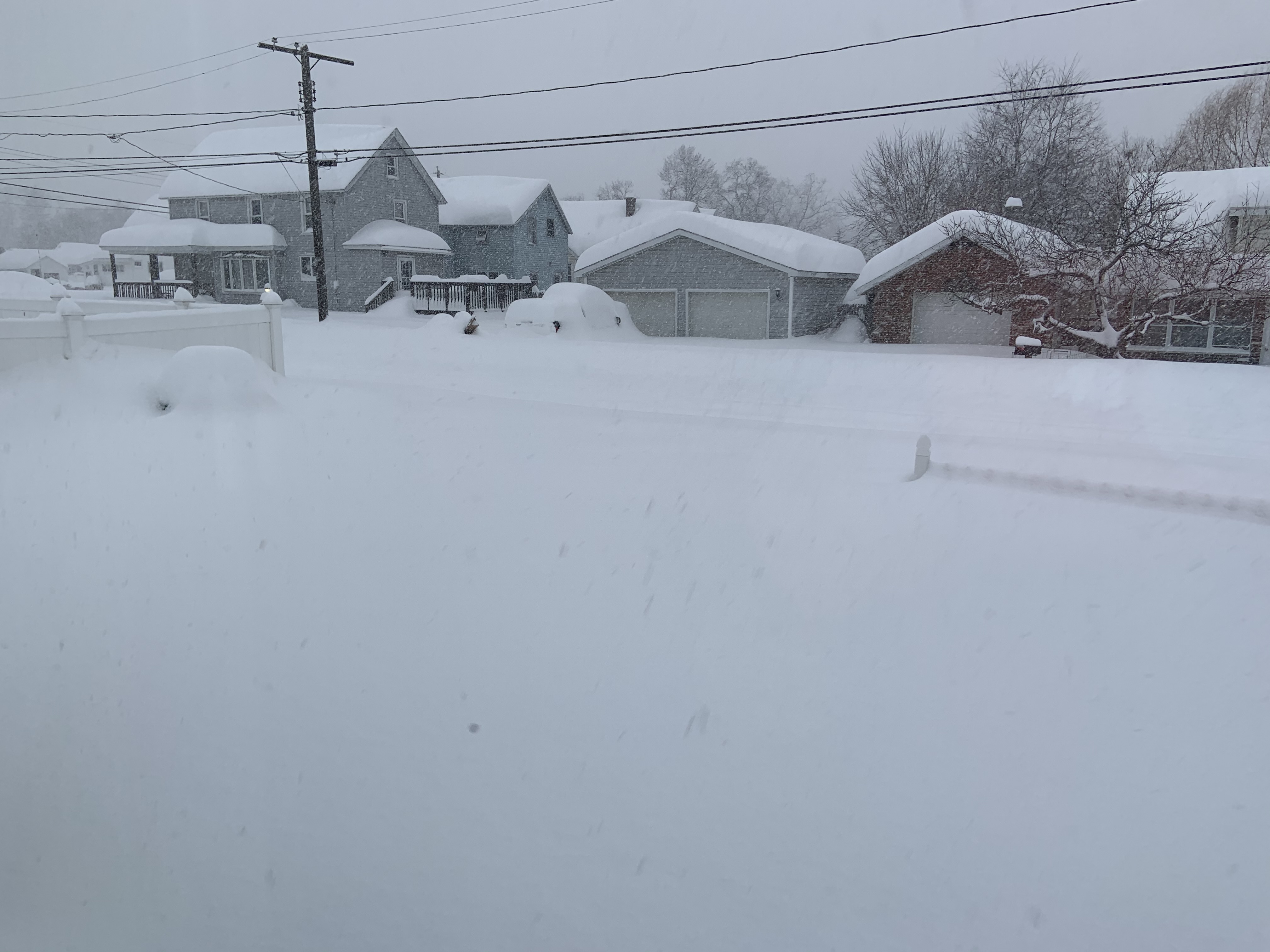 |
| Albany, NY (Dan Thompson) |
Rotterdam, NY |
Rotterdam, NY (Jennifer Vogt) |
 |
 |
|
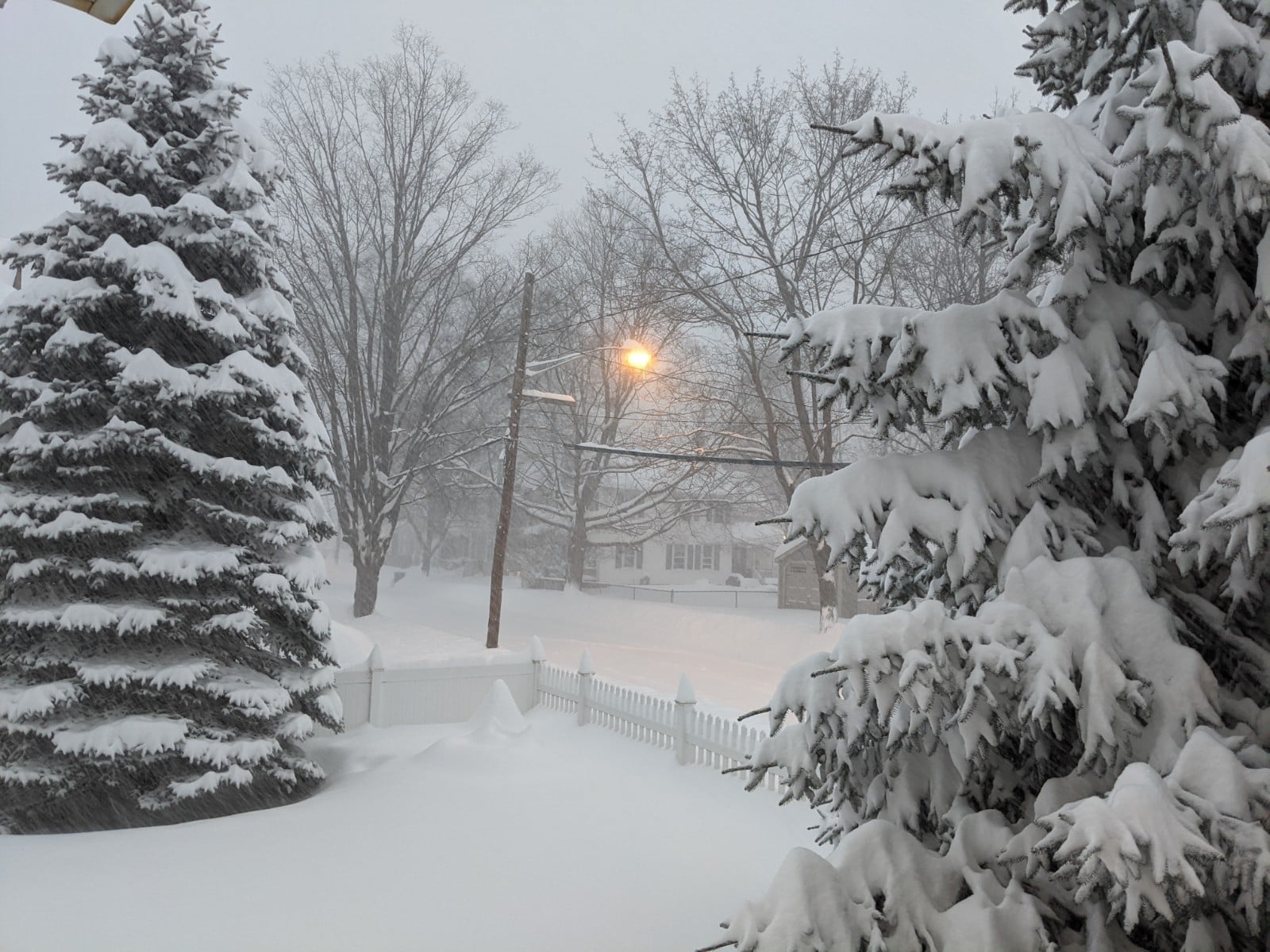
| Glens Falls, NY (Andrew Gregorio) |
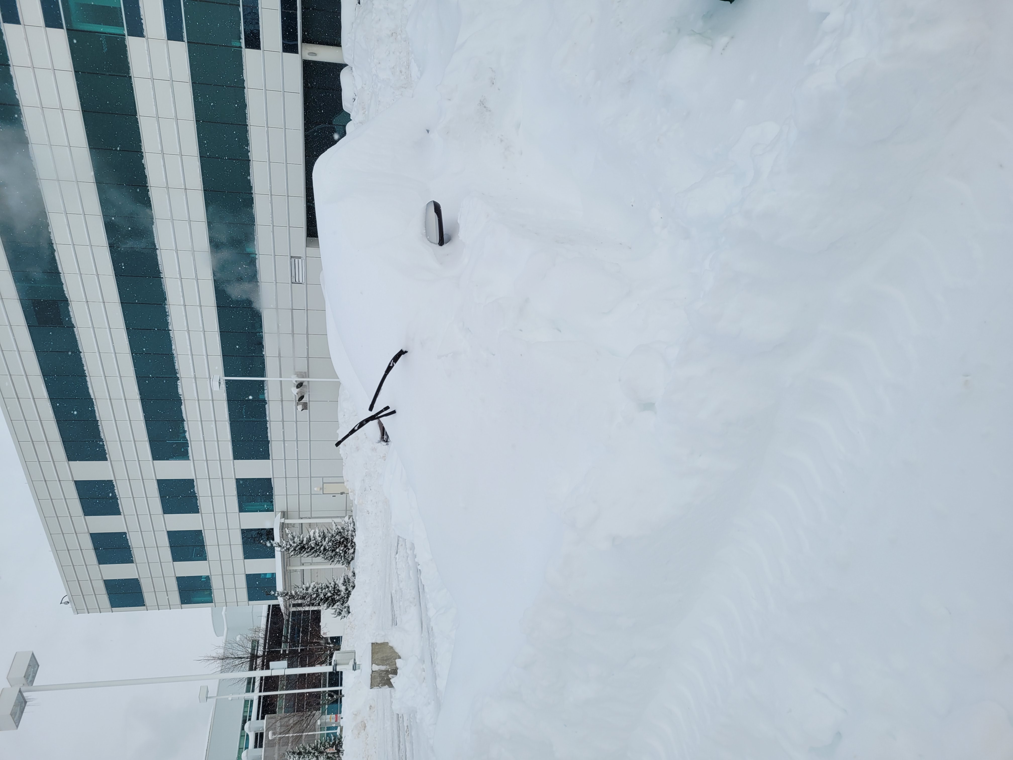
Albany, NY (Brett Rathbun) |
Radar
KENX Radar from 6:15 pm EST 16 December through 2:00 pm 17 December. Courtesy Iowa Environmental Mesonet.
 |
Media use of NWS Web News Stories is encouraged! Please acknowledge the NWS as the source of any news information accessed from this site. |
|

