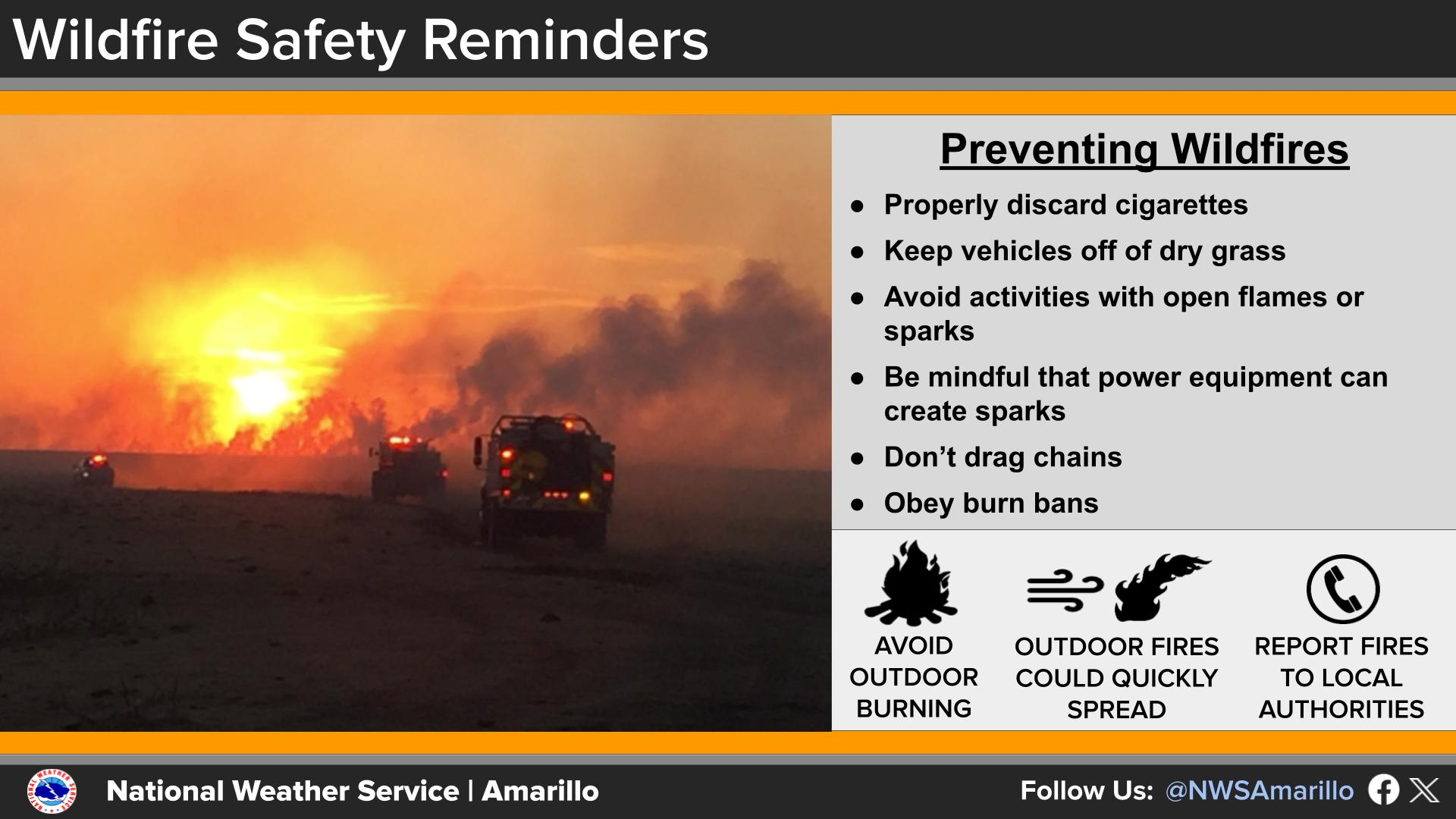
National Weather Service United States Department of Commerce
Click a location below for detailed forecast.

Last Map Update: Fri, May 8, 2026 at 11:22:28 am CDT

Thunderstorms will be possible Saturday and Saturday night across the eastern Panhandles, and a few thunderstorms Saturday afternoon and evening may become strong to severe with the primary hazards being large hail and damaging winds. However, the potential for thunderstorms will depend on where the dryline sets up by the mid-afternoon. If it moves too far east, then the threat for thunderstorms will be mostly in western Oklahoma.
If severe thunderstorms can develop on Saturday, the most likely time is between 6 PM to 9 PM across the eastern Panhandles.
The chance to see any rain from 3 PM Saturday to 7 AM Sunday ranges from 10-20% across portions of the north-central combined Panhandles to 50-60% in the northeastern Panhandles. This includes a potential round of thunderstorms Saturday afternoon and evening, and another potential round Saturday night. However, a few storms may become strong to severe with the afternoon/evening round. With that stated, the potential for thunderstorms will depend on where the dryline sets up by the mid-afternoon. If it moves too far east, then the threat for thunderstorms will be mostly in western Oklahoma.
Temperatures will become hot next week with consecutive days in the 90s, and even the potential for some to get into the low-100s on Tuesday. Heat Risk, which attempts to define the level of heat stress on any given day using the forecast highs, lows, longevity of the heat, and it factors in seasonal acclimation. Using these factors, we are expecting a moderate Heat Risk next week with a 10-30% chance to see a major Heat Risk in the southern Texas Panhandle and along a portion of the Canadian River Valley such as Borger and Canadian.
Summer-like heat is expected to return next week across the Panhandles with highs in the upper-80s to upper-90s expected most days. Tuesday looks to be the hottest day of the week with some locations in the southern and central Texas Panhandle possibly reaching into the triple digits.

Text Product Selector (Selected product opens in current window)


Current Observations ( )
Location Sky/Weather Temp (°F) Dewpt (°F) RH (%) Wind (mph) Pressure (inHg) Remarks
 Amarillo
N/A
N/A
N/A
N/A
N/A
N/A
N/A
 Borger
N/A
N/A
N/A
N/A
N/A
N/A
N/A
 Canadian
N/A
N/A
N/A
N/A
N/A
N/A
N/A
 Dalhart
N/A
N/A
N/A
N/A
N/A
N/A
N/A
 Dumas
N/A
N/A
N/A
N/A
N/A
N/A
N/A
 Guymon
N/A
N/A
N/A
N/A
N/A
N/A
N/A
 Hereford
N/A
N/A
N/A
N/A
N/A
N/A
N/A
 Pampa
N/A
N/A
N/A
N/A
N/A
N/A
N/A
 Perryton
N/A
N/A
N/A
N/A
N/A
N/A
N/A
 Amarillo 9NNE
N/A
N/A
N/A
N/A
N/A
N/A
N/A
 Amarillo 7SSE
N/A
N/A
N/A
N/A
N/A
N/A
N/A
 Bootleg 11WNW
N/A
N/A
N/A
N/A
N/A
N/A
N/A
 Canadian 6E
N/A
N/A
N/A
N/A
N/A
N/A
N/A
 Clarendon 2WSW
N/A
N/A
N/A
N/A
N/A
N/A
N/A
 Claude 12SW
N/A
N/A
N/A
N/A
N/A
N/A
N/A
 Hereford 2NW
N/A
N/A
N/A
N/A
N/A
N/A
N/A
 McLean 1E
N/A
N/A
N/A
N/A
N/A
N/A
N/A
 Palo Duro SP
N/A
N/A
N/A
N/A
N/A
N/A
N/A
 Pampa 2E
N/A
N/A
N/A
N/A
N/A
N/A
N/A
 Umbarger 3NNE
N/A
N/A
N/A
N/A
N/A
N/A
N/A
Note: "N/A" or "MISG" will be displayed if values are not available. In the LOCATION column, click on links for a list of recent observations at sites of interest. In the WIND column, VRB is "variable" and G is "gust". In the REMARKS column, HX is "heat index", WCI is "wind chill index", and VSB is "visibility" (if shown).


Aviation Drought Fire Weather Hydrology Severe Weather Winter Weather
 
Climate Graphs Hourly Forecast Long Range Local Model Data Precip Maps Heat
 
Education Local Research News Skywarn Weather Calculator Weather Radio