Dangerous heat will expand from the Gulf Coast into the Southern Plains and Desert Southwest through week's end. Additional extreme heat impacting the Pacific Northwest will shift to the northern Plains by the weekend. Tropical Storm Bertha is expected to continue to impact portions of the northern Gulf Coast from the western Florida Panhandle to southeastern Louisiana through tonight. Read More >
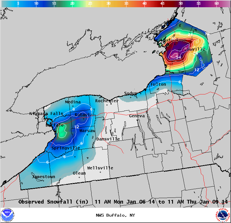
Lake Effect Summary - January 6-9, 2014
|
|
|
Maximum Snowfall: Lake Erie 22" (Orchard Park); Lake Ontario 60" (Rodman) Duration: 60 to 72 hours +/-
Prime feature: Excessive snow on the Tug Hill and blizzard conditions in Buffalo This was certainly one of the premier lake effect events of a very active winter season. Blizzard conditions were experienced across a large portion of the Niagara Frontier, including the Buffalo Metropolitan area, while over 5 feet of snow fell on the Tug Hill Plateau. All of this coming as a result of anomalously cold air that made its way south from the Canadian Arctic. A very deep…full latitude trough, centered over the plains of North America on Jan 5th, opened the door for some of the coldest air of the season to pour southward from Northern Saskatchewan. The frigid airmass, with 850mb temperatures of 25 to 30 C below, charged across the Northern Plains to the Upper Mississippi Valley during the weekend leading up to the event. Climatologically, this set the stage for a significant lake effect snow event. The largest lake snows in the Buffalo metro area typically occur when the cold air lifts out of the Ohio Valley and up the full axis of Lake Erie, rather than taking a direct route from the Upper Great Lakes or Southern Ontario. The slow track of the upper level vortex and its associated surface low were also recognized as key elements to portend a crippling snowfall. This pattern recognition played a huge role in forecasting this event. Lake effect snow watches were issued three full days ahead of the event with lake effect snow warnings issued over 30 hours before significant snows accumulated. As the event unfolded, blizzard warnings were issued in the Buffalo Metro area for the first time since 1993. The likelihood of blizzard conditions and snowfall amounts of 5 to 6 feet (for the Tug Hill) were discussed in the Area Forecast Discussion and with various radio media outlets days before the event. On Monday, Jan 6th, all of the elements came together to start one of the most memorable lake effect snow events in years. A deepening surface low passed just to the west of Buffalo early in the morning while sweeping a powerful cold front across Western and North Central New York. Wind gusts over 55 mph were produced as the leading edge of a much colder air mass poured across the region. As the cold air deepened over the Lower Great Lakes during the course of the day, multiple bands of lake effect snow developed over the east end of Lake Erie and across much of Western New York. While snowfall rates with the disorganized lake snows were generally less than one inch per hour through much of the afternoon, winds averaging 25 to 40 mph produced near white out conditions. The multiple bands of snow off Lake Erie then consolidated into one plume of moderate to heavy lake snow during the evening. This band concentrated its 1 to 2 inch snowfall rates on sites just south of Buffalo, on a line stretching from Hamburg and Orchard Park, to Elma, Cowlesville and Attica. After days of close coordination, the New York State Thruway from Henrietta to the Pennsylvania state line were closed for the night and the next day (7th). While the accumulating snow was certainly an issue, the larger problem was the blowing and drifting snow with hours of near zero visibility from winds that consistently gusted to 40 mph. As is usually the case, the lake snows off Lake Ontario took several more hours to evolve. Multiple bands of snow started to develop during the midday hours on the 6th and continued through the evening hours before a single band of heavy snow began to flourish. This band consolidated north of Watertown, in the Thousand Islands Region, then steadily marched south to the Tug Hill Plateau during the overnight. By daybreak on Tues, the 7th, the lake band was lifting back north towards Watertown. This main band oscillated back and forth between Watertown and the north slopes of the Tug throughout the day, while a weaker secondary band was positioned some 25 miles to the south. Snowfall rates of 1 to 3 inches per hour were noted with the primary band. The winds were nearly as strong with this activity as that off Lake Erie. Frequent wind gusts over 30 mph produced significant blowing and drifting with white out conditions at times. During the course of Tuesday night and Wednesday (the 8th), the deep long wave trough over Eastern Canada and the lower Great Lakes pushed to the east, while at the surface, strong high pressure drifted across the southern states. This ensuing warm advective pattern lowered the cap over the lakes, which in turn, eventually led to the weakening of the on-going lake snows. The lake snows started to weaken off Lake Erie late Tuesday night, as increased shear and a lowering of the cap encouraged the lake effect to become multi-banded with snowfall rates generally under an inch per hour. Surface wind speeds also subsided, so the prolonged blizzard conditions finally came to an end. Off Lake Ontario, the intense 1 to 3 inch snowfall rates persisted through the night and into Wednesday morning. As the upper level flow became more zonal and the surface high build across the Mid Atlantic States Wednesday night and Thursday (the 9th), the lakes snows tapered off to flurries.
This event will not only be remembered for the prolonged period of blizzard conditions across parts of the Niagara Frontier and the four to five feet of snow east of Lake Ontario, but for the agonizing stretch of brutal wind chill values of 10 to 30 below zero. This certainly made this one of the more dangerous lake effect events in recent memory. It could have been worse though for those downwind of Lake Erie, as 60 percent ice coverage tempered what otherwise could have been twice the snowfall.
|