A heat wave over the Southwest will intensify this week, peaking and expanding into the Intermountain West and northern High Plains this weekend. Critical to extremely critical fire weather conditions are forecast from the Northwest and the northern Great Basin this weekend. Particularly Dangerous Situation Red Flag Warnings have been issued. Read More >
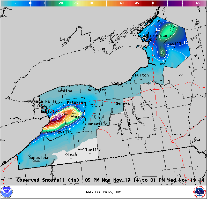
Lake Effect Summary - November 17-19, 2014
|
|
|
Maximum Snowfall: Lake Erie 65" (S. Cheektowaga); Lake Ontario 22" (Philadelphia) Duration: 48 hours +/- Flake rating: 5 flakes*****
The epic November 17-19th 2014 lake effect event will be remembered as one of the most significant winter events in Buffalo’s snowy history. Over 5 feet of snow fell over areas just east of Buffalo, with mere inches a few miles away to the north. There were 13 fatalities with this storm, hundreds of major roof collapses and structural failures, 1000s of stranded motorists, and scattered food and gas shortages due to impassable roads. Numerous trees also gave way due to the weight of the snow, causing isolated power outages. While this storm was impressive on its own, a second lake effect event on Nov-19-20 dropped another 1-4 feet of snow over nearly the same area and compounded rescue and recovery efforts. Storm totals from the two storms peaked at nearly 7 feet, with many areas buried under 3-4 feet of dense snowpack by the end of the event.
The storm began Monday around 6PM evening (Nov 17) as a band of snow developed over the Buffalo Southtowns and quickly moved into the Northtowns with thunder and lightning. However, the band settled south fairly quickly...and by 9PM the band had moved mostly just south of the city and airport and locked in place as the 15-20 mile wide band centered on a line from Lackawanna and Hamburg ENE across West Seneca, Lancaster, and Alden. The northern edge of the lake effect band was so striking that many described it as a wall of snow. Snow rates on the northern edge easily exceeded 3 inches per hour with some snow rates near 6 inches per hour. By sunrise some areas had already exceeded 3 feet of snow. This occurred in under 12 hours. Meanwhile, the southern edge of the band was located along the Lake Erie shoreline in Chautauqua County to near the Southtowns, including Orchard Park, East Aurora, and east into Wyoming county including Attica where about a foot of snow had fallen by sunrise. Travel across the Southtowns was nearly impossible with most roads unplowed as plows, at least those that weren’t stuck, focused a few main roadways needed for emergency vehicles. The Thruway was was shut down from the PA border to Rochester, and other routes, including 190, 290, and 400 were also shutdown.
During Tuesday November 18, the snow band didn’t budge, and by nightfall snow amounts from Lancaster to Southern Cheektowaga east to Alden had accumulated in excess of 4 to 5 feet by the end of the day. The wall of snow was still quite apparent with blue skies to the north and zero visibility on the other side. On Transit Road, there were only a few inches on the ground at Genesee Street, but several feet of snow at Walden Avenue less than 2 miles to the south. Winds gusted to 35 mph...and briefly gusted higher along the edges of the band...but in general winds created sub-blizzard conditions. There were still whiteout conditions however as snow continued to fall in excess of 3 inches per hour.
The band began to waver a little to the south Tuesday night...but overall continued in a slightly weaker state over the southtowns. Finally, the band let up as it drifted to the north and weakened rapidly Wednesday morning.
East of Lake Ontario, a lake band developed south of Watertown Monday night, then drifted north across the city and ENE to Harrisville. This band produced stronger winds than its Lake Erie counterpart, with gusts mostly in the 40-50 mph range with a peak gust to 55 mph at Watertown, producing blizzard conditions at times. By Tuesday night the band settled south over the Tug Hill Plateau, then quickly moved north Wednesday morning. Storm totals were highly variable, with snow amounts generally ranging between 1-2 feet in the hardest hit areas.
From a climatological perspective, the storm had signs of an unprecedented event early on, with historical analogs and climatological ensembles pointing to a rare if ever seen event over a 30 year climatology. 500 mb temperatures eventually dropped to -42C on the KBUF sounding Tuesday evening. With lake temperatures around 9C, lake induced equilibrium levels exceeded the 500mb level and maxed out near 20000’. Further up in the atmospheric column, the 200mb heights were lower than anything in recent memory. The more traditional 850mb temperature value of -15C was also on the lower edge of the climatological spectrum. From pattern recognition, this was a high confidence event...with “feet” of snow in the forecast over four days in advance. Data from the Saint Louis University CIPS (Cooperative Institute for Precipitation Systems) showed several analogs that matched 24 hour record snow events for Buffalo. Locally generated climatological analogs also showed that this event fit the bill for a significant event. The office had 56 hours lead time on a Lake Effect Watch and 32 hours lead time on a Warning. The office mentioned 3-5 inches per hour in the Warning prior to the start of the event, and mentioned 2-3 feet forecast with additional significant amounts with the next event later in the week. Travel was forecast to become nearly impossible.
On a side note, this has happened before. During December 14-18, 1945. The airport measured nearly 37 inches with in excess of 70 inches just 4-6 miles south (Lancaster).
|