Dangerous heat will expand from the Gulf Coast into the Southern Plains and Desert Southwest through week's end. Additional extreme heat impacting the Pacific Northwest will shift to the northern Plains by the weekend. Tropical Storm Bertha is expected to continue to impact portions of the northern Gulf Coast from the western Florida Panhandle to southeastern Louisiana through tonight. Read More >
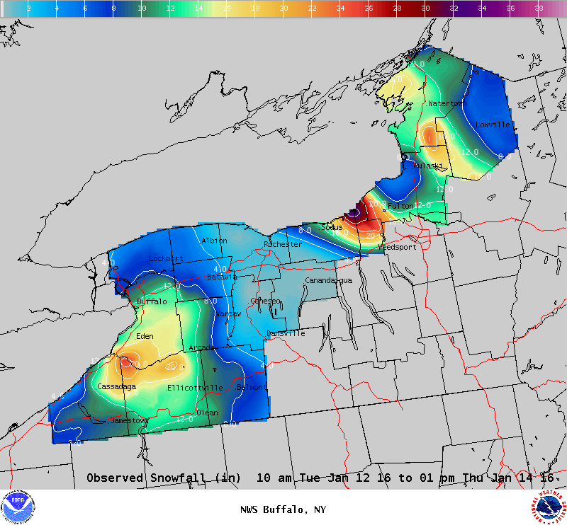
Lake Effect Summary - January 12 - 14, 2016
|
|
|
Maximum Snowfall: Lake Erie 25.5" (Perrysburg); Lake Ontario 42" (Lorraine) Duration: 60 hours +/- Flake Scale: 3 flakes *** The lake effect event that spanned the period Tuesday morning, January 12, 2016 through Thursday afternoon, January 14, 2016 started with a meso-low ahead of a squall line/lake effect hybrid that stretched across Lake Erie and into Southern Ontario. The line formed within a tongue of warm air aloft feeding into a deepening low over Southern Ontario, and was therefore not a true lake effect event. Lightning was quickly noted at around 8AM near the developing meso-low, which eventually brushed by Niagara County. There were whiteouts with this feature, along with a report in Tonawanda of 3” in 30 minutes. As the rest of the squall line moved into Western NY around 1130AM, thundersnow and whiteout conditions were experienced as gusts within the line produced gusts mostly between 30-50mph. KBUF was an outlier, and had a gust to 64 mph. The line, now without any lake connection, continued east and actually bowed out in a summer-like convective fashion as it moved through Rochester, across Lake Ontario, and into the Eastern Lake Ontario region between 4-5PM. Despite the impressive looking feature, snow amounts with this event were minimal and not long lasting. East of Lake Erie and behind the squall line, a short-lived lake effect event developed primarily east of Lake Erie. Initially a line formed along the Lake Erie shoreline in Chautauqua County northeast into the Southtowns where about 3-5 inches fell during Tuesday afternoon, but this soon fell apart as the flow veered to the northwest. After about 9PM, a multi-band setup lasted most of the night and eventually merging into two thin distinct bands, one from about Dunkirk east-southeast toward Machias, with another one from about Westfield to Randolph. As result, overnight amounts were highly variable, with anywhere from a trace to as much as 18” toward Machias. During much of the day on Wednesday, the southern band slowly strengthened as it gained increasing amounts of fetch with a backing flow aloft. It managed to get through most of the Southtowns, dropping generally 3-6 inches, highest toward the lakeshore. Once it got into the Buffalo Metro area shortly after dark, it really exploded with snow rates in excess of 3 inches per hour. The airport quickly accumulated nearly 11 inches as the band slowed its northward progress. Once the band moved past the Northtowns however, it fell apart. The band then reformed overnight and eventually surged across the area, quickly dropping another roughly 2-4 inches in the process. Northwesterly flow developed behind this with a short-lived multi-banded structure during Thursday morning over the Southern Tier. This did not last long as warm air advection and lowering inversion heights finally put an end to the event. Meanwhile east of Lake Ontario, minor lake effect developed behind the squall near the St. Lawrence River Tuesday evening, then another burst of snow moved across the entire region toward before midnight with a secondary front that moved into the region from the Lake Huron/Georgian bay area, mostly missing Western NY. Finally, true lake effect developed over Northeast Wayne, northern Cayuga, and Eastern Oswego Counties for the remainder of the night. There were highly variable amounts of snow during this time, with amounts toward a foot over Eastern Wayne and Cayuga Counties, and a half foot further east in to Southern Oswego County. Meanwhile, another band extending from the upper Great Lakes region continued across far Western Lake Ontario and pummeled Niagara and portions of Orleans Counties for a few hours during the morning. It didn’t last long before the band drifted off the coast, but it dropped a quick 4 inches or so and made the morning commute quite difficult. Back on the eastern end of the Lake, the band over Cayuga and Western Oswego Counties didn’t move much during the day and didn’t start to gain strength again until well after dark after it drifted north toward the Watertown area Wednesday evening. It eventually stalled between about Watertown and the St Lawrence River for the remainder of the night, leaving near a foot of snow in some spots. Finally, on Thursday, the band moved south, eventually settling over the county triple point, strengthening for a period in the afternoon, then finally succumbing to the warm air advection aloft. This event earned 3 flakes ***.
|