Numerous severe thunderstorms are expected across a broad region from the Ohio Valley to the Mid-Atlantic and Northeast States today into tonight. Swaths of damaging wind gusts are expected and some tornadoes are possible. Bertha is expected to bring tropical storm conditions to portions of the Gulf Coast from the Florida Panhandle westward to southeastern Louisiana later today and Wednesday. Read More >
Lake Effect Summary - January 17 - 19, 2016
|
|
|
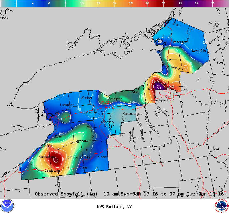
Maximum Snowfall: Lake Erie 18.5" (Little Valley); Lake Ontario 22.4" (Fulton) Duration: 60 hours +/- Flake Scale: 2 flakes ** After brief respite from the January cold, and lake effect snow, arctic air flowed over the eastern Great Lakes Sunday, January 17th, with early weekend air temperatures in the 40s plummeting back below freezing. Our 6th lake effect event began Sunday morning. Synoptically, this event featured a broad and deep upper level low over the Great Lakes region. This feature brought arctic air southward with temperatures at 850 hPa dropping to as low as -20c over the still unfrozen lake waters. Ahead of this upper level low, surface winds were southwesterly and this brought the initial band of lake effect snow across far northern Niagara Frontier early Sunday morning. Off of Lake Erie, a moderate snowband remained over Niagara County through the early afternoon hours. As a surface trough approached New York State through the late morning hours, winds veered, and this began the southward drop to the snow band. Snow fell across the metro Buffalo region Sunday afternoon at a clip of 1 to 2 inches per hour, in part due to enhance low level convergence along a surface trough. The band of snow maintained its southward movement, and yielded 4 to 6 inches over the Buffalo metro area. By Sunday evening the band of snow was over the Ski County and the western Southern Tier. A 280-290 flow over Lake Erie transitioned the lake effect snow band into multi banded structures through the night. By Monday morning a wide area of light to moderate lake effect snow continued east of Lake Erie. While the snowfall rates were not impressive, generally under an inch, the persistent state to the snowbands brought storm accumulations upwards to a foot to a foot and a half by Monday night. The core of the cold air aloft passed over the lake Monday, January 18th, and this brought a peak to the lake induced equilibrium levels. Lake effect snow slowly trailed off through the overnight hours Monday and early morning hours of Tuesday. Off of Lake Ontario light snow fell across the Saint Lawrence valley through the early afternoon hours of Sunday, January 17th. By late afternoon a south-southwest to north-northeast band of snow ahead of the surface trough pushed inland across eastern shoreline communities. Behind this trough cold air deepened to near -20c over Lake Ontario and this pushed lake induced equilibrium levels up to near 15k feet by early Monday morning. A well-defined band of lake effect snow formed late Sunday night, and early Monday morning on a westerly flow. This band of snow arced across northern Oswego County and the southern Tug Hill through the early morning hours of Monday, January 18th. Just before dawn veering winds organized the band of lake effect snow over the Wayne-Cayuga-Oswego corridor. This band of snow increased in intensity to over 3 inches per hour by midday Monday bringing dangerous travel conditions over the southeast shoreline of Lake Ontario inland towards Syracuse. This band of snow at times had upstream connection to not only Georgian Bay, but also Lake Superior. While the main band of lake effect snow off Lake Ontario flew over the southeast shoreline Monday, there was another band of snow, originating off Lake Huron, and across southwestern Lake Ontario that brought several inches of snow through the day across Niagara, Orleans and western Monroe counties. This northwest flow over Lake Ontario continued varying intensity to the snow bands through the night and into Tuesday, with subtle variations in the wind flow carrying the snows over the southern and southeastern shorelines. Behind the core of the cold air aloft, lake parameters began to diminish and this brought a decrease to the intensity of the bands of snow off Lake Ontario through the day Tuesday. Though this event ended Tuesday, light to moderate bands of snow continued along the southern and southeastern shorelines of Lake Ontario through Thursday adding several additional inches of snow. This event largely fell over the Martin Luther King holiday weekend, thus limiting the impact on local transportation. While there was a localized area of intense snow southeast of Lake Ontario Monday, the snow remained manageable through the event, and therefore a strong 2 flakes will be assigned to the event.
|