Scattered thunderstorms with severe gusts, hail and a tornado risk are possible near a cold front from the Ohio Valley to the Mid-Atlantic tonight. Tropical Storm Bertha is expected to bring tropical storm conditions to portions of the Gulf Coast from the panhandle of Florida into Louisiana through Wednesday. Read More >
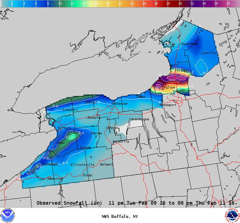
Lake Effect Summary - February 9-11, 2016
|
|
|
Maximum Snowfall: Lake Erie 14.0" (East Aurora); Lake Ontario 37.4" (Minetto) Duration: 48 hours +/- Flake Scale: 3 flakes *** Our 8th lake effect snow event of the year brought heavy snow to the southern Lake Ontario shoreline. The upper air pattern featured a trough of low pressure over the eastern United States and Canada, with climatology parameters of 850 hPa heights, and 500 hPa heights favoring heavy snow southeast of Lake Ontario. There was little lake ice to speak of this winter and this left the lakes wide open for lake effect snow generation. A surface low tracked across southern Canada Tuesday, February 9th, and by Tuesday night a westward flow of colder air began to flow across the eastern Great Lakes region. As 850 hPa temperatures dropped to around -12C, instability over the lake increased with lake effect snow east of Lake Erie beginning just past midnight Wednesday morning, and just before sunrise east of Lake Ontario on Wednesday morning. A 280 wind flow brought the steadiest snows east of Lake Erie across ski country through the day, while on the southwestern shoreline of Lake Ontario a band of snow hugged the shoreline, dropping upwards of a half a foot of snow. Several bands of lake effect snow passed east of Lake Erie through the day and night Wednesday, while upstream connections to Lake Huron (western half of Lake Ontario) and later Georgian Bay (eastern half of Lake Ontario) maintained bands of snow along the southern shoreline of Lake Ontario. By Wednesday evening the lake effect machine focused lake snows southeast of Lake Ontario where a band of snow with snowfall rates in excess of 3 inches per hour sat over Oswego County. This band of snow moved little through the night, and this allowed for upwards of three feet of snow to fall upon Oswego County by Thursday morning. Through the day Thursday winds veered to more northwesterly and this flow brought light multi-banded lake effect streams to the south and southeast of the lakes through the day. Overall accumulations Thursday were minimal, and by the early evening hours the lake effect snow activity was largely over with. The bulk of the snow fell through the evening and overnight hours southeast of Lake Ontario. Though brief, an intense band of snow dropped several feet of snow over a localized area across Oswego County. While this had significant impact on the local area, region wide east of the lakes the overall snow totals were manageable with less than a foot falling. This event will earn three flakes. Here are some representative snowfall totals for this event:
|