Dangerous heat will expand from the Gulf Coast into the Southern Plains and Desert Southwest through week's end. Additional extreme heat impacting the Pacific Northwest will shift to the northern Plains by the weekend. Tropical Storm Bertha is expected to continue to impact portions of the northern Gulf Coast from the western Florida Panhandle to southeastern Louisiana through tonight. Read More >
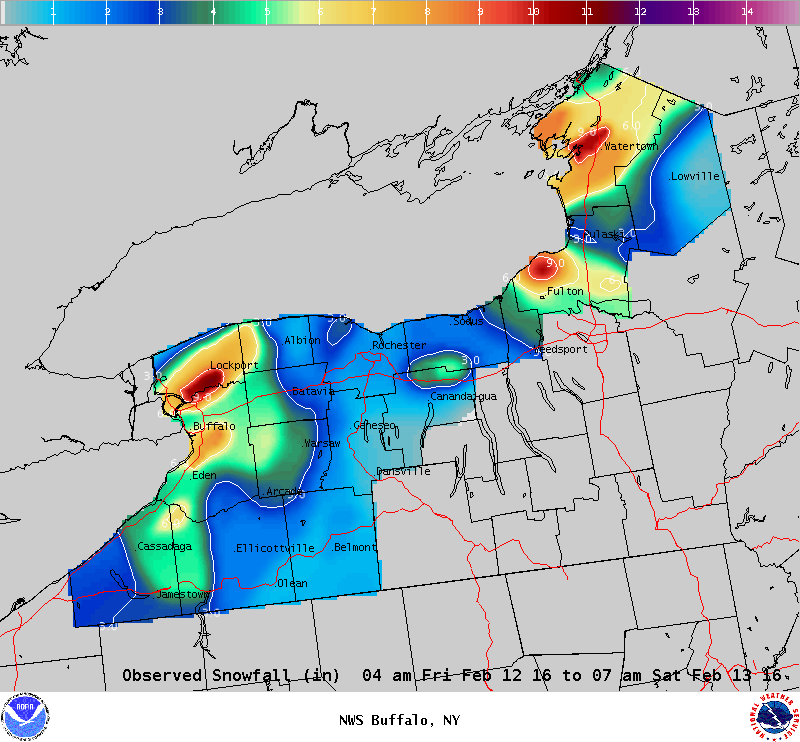
Lake Effect Summary - February 12-13, 2016
|
|
|
Maximum Snowfall: Lake Erie 11.3" (Rapids); Lake Ontario 11.0" (Oswego) Duration: 24 hours +/- Flake Scale: 2 flakes ** The 9th lake effect snow event of the season came on the heels of the 8th event, when after a pause in the lake effect snow at the end of the 8th event, a backing southwest wind brought lake effect snow again east of the lakes. A continued environment that was favorable for lake effect snow, including temperatures at 850 hPa dropping to around -16C, plentiful moisture within the lower troposphere that had equilibrium levels rising to nearly 15k feet and virtually ice free lake waters, bands of lake effect snow formed, first off Lake Erie early Friday morning February 12th, and later through the morning off Lake Ontario. Making this event a less than ideal set-up was a fair amount of wind shear, with the winds causing both an oscillation in the bands of snow, as well as temporary disorganized activity. Very early Friday morning a band of snow with snowfall rates up to 2 inches per hour formed along the southern Lake Erie shoreline and over the southern Tier, with the band of snow lifting northward to the vicinity of Buffalo during the rush hour. The poor timing of the snow band during the early morning rush led to several accidents, and slowing the morning commute. The band of snow weakened some during the morning hours as it sank southward back over southern Erie and Chautauqua Counties. By late morning the steering winds backed considerably to allow the band of snow to lift northward across Niagara, Orleans and northern Erie counties. Here is where the greatest snowfall accumulation fell, with upwards of a foot of snow falling through the afternoon and evening hours. During the late afternoon hours several rumbles of thunder were heard over Northern Erie County. Through the evening hours this band of snow sank southward towards the southern tier where it then diminished to light snow showers after midnight. Off of Lake Ontario an early lake effect snow band was over Oswego County Friday morning. As winds backed through the morning hours this band of snow lifted northward and disorganized as it reached central and northern Jefferson County where it then intensified through the afternoon hours. With some help from Lake Erie, a southwest to northeast band of snow blitzed the Saint Lawrence Valley and northern Jefferson County with nearly a foot of snow through the afternoon hours. Snowfall rates up to 2 inches per hour fell through the afternoon. By early evening a southward dropping arctic front pushed this band of snow southward. This front placed what was left of the lake effect snow along the southern shoreline of Lake Ontario by late evening. Following this arctic front some of the coldest air of the winter season swept across the eastern Great Lakes region. This event had an impact on both the early morning and evening commute for Buffalo, though overall snow totals remained a foot or less. Two flakes will be given to this event. Here are some representative snowfall totals for this event:
|