
Heat expands across the Desert Southwest, Plains, Mississippi Valley and Midwest into Monday. Fire weather concerns continue for portions of the Intermountain West. Active monsoonal moisture fuels thunderstorms over the Southwest with possible flash flooding. Tropical cyclone Fausto in the Pacific, should weaken as it approaches Hawaii; Dangerous surf, swells and rip currents are expected. Read More >
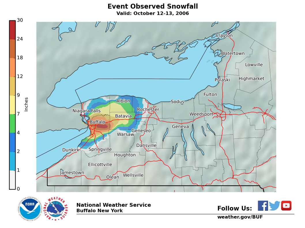
Maximum Snowfall: Lake Erie 24" (Depew,Alden)
Duration: 16 hours +/-
Prime feature: Dramatic crippling out of season event. Unprecedented meteorological parameters.
Words cannot due justice to the astounding event which opened the 2006-07 season. Not only was it the earliest event by far (two weeks) of the over 120 in the 13- year record of our lake effect archive…but it was the most unique in regards to destruction of trees and power outages…directly because of its out of season factor. Almost a million residents of the Niagara Frontier lost power...some for as long as a week…and tree damage was the worst in memory…especially to the lush vegetation in the many historic parkways and parks in the Buffalo area.
The event was not particularly well forecasted…although its extreme parameters were noted all week and even mentioned six days ahead in forecast discussions. The depth of cold air was almost unprecedented for so early in the season and Lake Erie was a mild 62 degrees, three degrees above normal for October 12. Instability levels were dramatic with 850 mb to sfc delta –t’s of 24c or so…inversion levels were simply off the chart at 25k feet with omega and Cape values unprecedented for a lake effect event. The only question...and a big one…was whether the boundary layer could be cold enough to maintain snow with a flow off a 62 degree lake. It was initially assumed that there would just enough moderation for the bulk of this forecasted intense lake effect storm to fall as rain...with perhaps some graupel or wet snow inland…but by Thursday morning (12th) it was becoming marginal…and a Warning was issued early Thursday afternoon for 1-6” of wet snow, specifically because of the fact that most trees were still in full leaf….and the threat of serious damage and associated power outages.
The event began with lake effect rain during Thursday morning and midday…and enough cold air became entrained to change over the precipitation to wet snow in the Buffalo area by 3 pm. Still…little accumulation resulted for a few hours, but by 8-9 pm, reports of trees falling and power outages suddenly increased rapidly after 2-3” of snow, which was very wet and weighed down the trees. Conditions only worsened overnight with near constant thunder and lightning for a good 12 hours. Cloud tops reached an incredible 25-30k feet…about double we have previously observed in the worst events…this was directly attributed to the phenomenal uplift over the 62 degree lake.
The heaviest snowband set up across the North Towns Thursday evening…then drifted south to the south Towns around midnight…then lifted slightly to the city and eastern suburbs in the wee hours before lifting north across the North Towns again around daybreak and eventually to Niagara county Friday (13th) morning where it weakened and faded to rain as the dynamic cooling process faded and allowed the boundary layer to moderate.
It was apparent that the associated uplift and dynamic cooling was so strong that it overcame any attempt of boundary layer warming from the lake. There even may have been cooling near its edge because of this dynamic cooling as evident by lowering dew points at Cleveland, Erie and Dunkirk early in the event…perhaps a sign of air advecting into the lakeband from the land.
Even though plenty of damage resulted already in the first few inches, total snowfall in this event was simply unbelievable. 5 to 8 inches fell in the first phase of the event between 3 pm and midnight, but SWE ratio was around 6:1 or so…hence the terrific damage to trees and powerlines. The second phase featured slightly drier snow…maybe 12:1 but it piled up another foot in heaviest area…in just 4 hours or so. The 22.6 inches recorded at the Buffalo airport not only blew away any October record (6” in 1909…only 4 falls of 2” or more in 100 yrs in October)….but was the 6th greatest snowfall ever at any time in Buffalo!
The crippling snows extended well across Genesee and Orleans counties, and pushed into extreme southern Niagara county...but there was a sharp cutoff to any damage, which ran along a line from Whitehaven Road on Grand Island to Wheatfield to Medina on the north, Leroy and Bergen on the east, and East Aurora and southern Hamburg on the south.
Governor Pataki declared a State Disaster Emergency in Erie, Genesee, Niagara and Orleans counties on Friday October 13. President Bush declared the four counties eligible for disaster assistance on October 24. (FEMA-1655-DR). By the beginning of December 2006, nearly $11 million in disaster grants and low-interest disaster loans were been approved. Over 400,000 National Grid and New York State Electric and Gas (NYSEG) customers lost power Thursday evening. Full restoration of power was not completed until 13 days after the storm with most regions being without power for about 5 days. Most area schools were closed for the entire week following the storm. One death was directly attributed to the storm. In Amherst, a man was clearing snow in his driveway when a tree limb broke off, fell and crushed him. Fourteen other deaths were indirectly storm-related. This number includes four people who died from carbon monoxide poisoning from the improper use of generators and kerosene heaters. Over two hundred were treated for exposure to carbon monoxide. Seventeen were treated for hypothermia. The seasonal timing and pre-conditions of the event only exacerbated the impacts. Only a couple inches of the heavy snow was needed to bring down the still fully leafed trees. In addition, the area had experienced a wet pattern prior to the storm. The wet ground made it easier for tree root systems to fail. Estimates to remove the debris from the storm is pegged at over $150 million. Over three million cubic yards of debris needed to be cleaned up. Local and State Departments of Transportation were not prepared for such an early storm. Most were still in paving mode and had not prepared their equipment to plow snow. The heavy snow also made driving even more difficult. About a hundred mile stretch of the Thruway was closed. Hundreds of motorists were stranded between Pembroke and Angola. Some of these people were stranded for twelve to eighteen hours. Other transportation issues included motorists not being prepared for winter driving and tractor trailers not using the proper fuel mix for the wintry weather. Most areas initiated driving bans and declared States of Emergency early in the onset of the storm.
Finally, all snow melted within about 48 to 60 hours with little flooding.
Here are some representative reports….
Depew			24 inches
Alden (Milgrove)	24 inches
Cheektowaga (NWS)	22.6 inches
Buffalo (North)		20 inches
-Downtown		15 inches
-South			10 inches
Amherst			14 to 22 inches
Clarence		16 to 22 inches
Tonawanda		12 to 18 inches
West Seneca		14 inches
No. Tonawanda		6 to 12 inches
Hamburg			8 to 14 inches
Orchard Park		8 inches
Batavia			10 inches
Medina			8 inches
Lockport		6 to 8 inches
Grand Island		2(N) to 10”(S)
Albion			5 inches
Brockport		3 inches
Niagara Falls		1 inch

