Winter 2008 - 2009
|
|
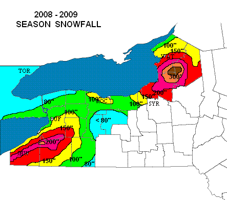
The winter was yet another interesting one across western and central New York and featured
all types of conditions. Overall, snowfall was near to slightly above normal in most of the
area, but was focused almost completely from late November through January. This period was
on the mark for near record snowfall, then the snow machine virtually shut down from early
February on, with near record lack of snow for winter's second half. The totals showed a
typical climatological pattern, with very high amounts focused on the Chautauqua ridge and
east into Wyoming county in western New York (200 inches plus), and the Tug Hill in central
New York (over 300 inches). The main anomaly was the unusually heavy snow in the Watertown
area in December and January when several lake effect events pummeled the city.  There was
also an unusually have snowfall in late October over our eastern lake Ontario region, even
at lower elevations. A couple of early April snowfalls…mainly elevation dependent, rounded
out the season.

The snows in November and December…even though heavy, mostly melted off during an extreme
thaw and windstorm during the Holidays…while severe winter cold and daily snows set in for
the entire month of January and into the first week of February. Then dry weather and
moderate temperatures were the rule through March. Snow depths were nothing out of the
ordinary due to the frequent/freeze thaw cycles early in the winter and lack of snow during
the latter portion.

As for lake effect, there were 13 "events", 2 more than the average of 11. But 12 of them
occurred from Nov-Jan with only a single one thereafter. Most were on west to northwest
flows, with only one significant one affecting the Buffalo area (Dec 21). Both Buffalo and
Rochester had near normal snowfall overall, generally 80-110 inches across the metros, but
again, it was "front end" loaded, with half falling in December. In fact, almost 1/3 of the
entire winter snowfall in the Buffalo area fell during one wild weekend, Dec 19-21.
Rochester had their snowiest December ever. The lowest season amounts fell over the mid
Genesee Valley as usual with 50-70 inches. The St. Lawrence valley did have above normal
snowfall due to several synoptic events.

One other unusual aspect of the winter season was the flooding in western New York. Three
separate events occurred, at end of December, early February and early March. The first
being a rapid snowmelt/rain event and the other two heavy rains on frozen ground.

Monthly details follow...

OCTOBER 2008

For the first time in several years, portions of our area had some decent snowfall to report
in October, all courtesy of a major synoptic storm which affected the region on the 28-29th.
Enough cold air was in place to allow for most of the precipitation to fall as heavy wet
snow east of Lake Ontario, even at lower elevations with up to a foot in the Watertown area
and up to two feet on the Tug Hill. A few inches also fell in wraparound lake enhancement
over higher elevations in western NY as well.


NOVEMBER 2008

November was really a tale of two completely different seasons across our region, is first
half was very mild a dry, some 6 to 10 degrees warmer than normal, with the best "Indian
Summer" in years as first week featured five days of sunshine and near 70 degree
temperatures. This pattern changed abruptly at mid month however as a huge upper low over
eastern Canada set up and produced a persistent and strong northwest flow of polar to
arctic air across the Lakes and Northeast. The last two weeks averaged 6 to 10 degrees
colder than usual. This pattern proved very persistent through January. As we know, cold
early season weather and warm lake waters do not mix, and lake effect was extremely active
with no less than 5 lake effect "events".  Significant falls occurred on the 16-19th,
20-23rd, 26-27th and 28-29th. These were all west to northwest flow events which favored
higher elevations of the western southern tier and Oswego county to the Tug Hill. The one
good southwest event on 9-10th fell mainly as rain in the Buffalo area. Aside from the lake
effect, November was a dry month with few synoptic storms. Monthly snowfall varied widely
across the region with near record 60 to 80 inch amounts on the Tug Hill but only 14" at
Lowville in the valley. Out west, over 70" fell on the Chautauqua ridge, but only a few
inches in the Buffalo area.

DECEMBER 2008

December was a very memorable month across the region and featured just about every
meteorological parameter from general snowstorms and lake effect to damaging winds, brief
record warmth, heavy rainfall and flooding. Snowfall was heavy everywhere, the bulk of it
falling during the last two weeks. This included two major widespread synoptic snows of
6-12" throughout, one on the 19th, the other on 31st. There were three lake effect events
with one on the 21st of near blizzard proportion for several hours in the Buffalo and
Watertown areas. Snowfall was way above normal everywhere, with amounts of 25 to 40 inches
in non-lake effect areas and up to 60-80" in the snowbelts. Rochester had its snowiest
December ever. Despite all this though, a major warmup and rainstorm cleared the ground of
snow over lower elevations on 29-30th, just in time for another general snow on New Year's
Eve.

JANUARY 2009

January was a harsh month of deep midwinter cold and almost daily snowfall across the
region. After a relatively benign first week, temperatures averaged 6 to 10 degrees below
normal for the rest of the month, the coldest winter month in 5 years. There were two
synoptic events, on 10-11th with 4 to 8 inches and on 28th with a general 6 to 10 inches.
All the rest fell as lake effect, with repeated dumps on snowbelt areas east of Lake Erie
until the lake froze, while Lake Ontario's snows kept up all month. There were four lake
effect "events", on 7-9th (northwest/lake Huron connection), 16-17th, 24-27th and 30-31st.
These final three were unusually heavy up into the Watertown area. Lake Erie became ice
filled by mid month, seriously toning down the lake effect there. In fact, the final week
was a good example of the implication of a frozen lake. With a southwest flow, Watertown
caught 30 to 40 inches, while the Buffalo area more like 3 to 6", on a similar situation
on a southwest fetch. Monthly snowfall totals were above average everywhere, with a few
spots on the Chautauqua ridge and on the Tug Hill near 100 inches. Season totals through
January are among the highest in our 14 year record to date with over 200 inches in these
spots. Most areas have received their total annual snowfall, or more, and this is only
through January.


FEBRUARY 2009

In a rather dramatic reversal to the winter to date, February feature a major break from
the near constant snow and cold of the past 6 weeks. It was a changeable month with two
warm periods (7-12th and 25-27th) with plenty of rain, and some minor snowfalls during its
colder periods…especially on 14-24th. There was only one major lake effect event, on
19-21st, which dropped 2 to 3 feet of snow on the Tug Hill, and over a foot across Oswego
county. 3 to 6 inches even fell back across the Rochester area. Several inches also fell
in the high ground southeast of Lake Erie with considerable upsloping. The mild spell
toward month's end melted nearly all of the snow at lower elevations. Buffalo and
Rochester has only trifling amounts of snow on the ground during the middle and latter
portion of the month.


MARCH 2009

Snow?  Not this month. In fact, March was the least snowy winter month (Nov-Mar) overall
that we have ever monitored since our network began back in 1994. Many of our spotters had
no snow or a trace, with the bulk having only an inch or less. Buffalo had its least snow
in 63 years and 2nd least ever. Most remarkably, even our usual snowbelt areas only
received a trifle. The high ground south of Buffalo caught no more than 3 or 4 inches, and
the Tug Hill only 1 to 3 inches!! Redfield and Hooker, both with over 340 inches through
February, had only 2 and 3 inches for the entire month of March! This was less than Atlanta
GA which caught 4 inches this month!!! Overall, an unusually sunny dry and mild month, which
came in and left like Lambs.


APRIL 2009

April was rather typical, and did include a couple of wet snowfalls during the first week.
As is usually the case during out of season snows, these were highly elevation dependent.
The first, on 3-4th dropped 3 to 6 inches over higher elevations of western NY, and up to
8-18" on the Tug Hill. This was a rain changing to snow scenario. The second, mostly on the
7th, featured some wet snow everywhere, with an inch or two at lower elevations, but again
up to 6" over high ground in ski country of the west and locally a foot over the Tug Hill.
That was it for the snow though, as a long dry period ensued through mid month, and summer
weather moved in for the final week of the month.