
Widespread, life-threatening considerable flash flooding is expected in south-central Texas through at least Friday. Catastrophic river flooding and rapid rises on small streams, arroyos, and typically dry washes are expected in the Texas Hill Country. Wildfire smoke is impacting air quality across much of the Great Lakes region into the Northeast U.S. with Air Quality Alerts in effect. Read More >
Winter Summary 2019-2020
|
Winter 2019-2020 Hemispheric Discussion For the second year in a row, the winter of 2019-20 was a disappointment to those that enjoy the crisp, snowy weather that typically characterizes western and north central New York. The forecast of a weak El Nino initially offered some hope for snow lovers that we would experience a ‘good old fashioned winter’, as local research has found that weak ENSO events have been favorable for supporting colder than normal weather. In this case though, that proved not to be true.
Neutral or weak ENSO events usually allow highly amplified jet stream patterns to become established over North America. This allows for occasional cross polar flows and subsequent arctic intrusions. During the winter of 2019-20 though, a low amplitude jet stream dominated the country with significant positive height anomalies generally anchored some 1000 to 1500 miles off the West Coast. The corresponding teleconnection would typically include troughing and relatively cold weather immediately downstream over the western third of the country with another ridge found further down wind over the Great Lakes. With the exception of November, this is pretty much what we experienced.
While the placement of the various troughs and ridges were certainly contributing factors to our ‘warm’ winter, an equally important factor was a notably low amplitude jet stream overhead. This pattern is atypical during weak El Nino seasons. In fact, there were long stretches where the flow was nearly zonal. This results in the bulk of the country being flooded with Pacific modified air while also blocking arctic air from making its way south of the Canadian border. In this particular case, the true cold air was locked up north of 55N latitude.
So as we opened the cold weather season in November, the weak El Nino seemed to be verifying perfectly. A fairly amplified jet stream pattern was in place over the continent and this enabled temperatures throughout western and north central New York to drop to more than 5 degrees below normal for the month. While there is only a very weak correlation to temperatures and snowfall, the colder than normal weather supported enough lake effect snow to allow most areas to finish off the month of November at above normal levels. For the bulk of the region, this would be the most wintry weather of the season.
The overall pattern experienced a significant shift for December. Not only did the highly amplified flow from November become much more zonal, but the MJO (Madden Julian Oscillation) became very active. The MJO is another global weather phenomena that deals with eastward moving upper level pulses in the tropics. These bundles of energy recur on average every 30 to 60 days and can have an impact on the jet stream at latitudes outside of the tropics. In this particular case, moderately strong MJO activity fed into the emergence of a strong East Asian jet; one that would persist for much of the remainder of the winter. All of this translated into temperatures that averaged near to as much as 3 degrees F above normal for the month. This suppressed lake snow in the typical snow-belts where monthly departures were down by one to two feet. Many areas experienced a snowless Christmas with temperatures in the 50s.
While many felt that December was mild, it was the month of January that really turned heads. A powerful East Asian jet of 150 to 200 kts dominated the northern Pacific during this month, while a zonal flow over the contiguous U.S. guaranteed a wealth of Pacific modified air. This combination completely shut off any cold air from moving south of the international border and enabled temperatures to average an astounding 6.5 to more than 8 degrees F above normal. Snowfall suffered throughout the region, with many areas falling short by nearly 24 inches for the month.
Some amplification in the longwave pattern returned to North America during the month of February. But, with a relatively strong East Asian jet still in place, our temperatures remained staunchly above normal by roughly 3 degrees F. It’s also worth noting that the lack of any significant blocking in the form of a Greenland ridge (-NAO) or west coast ridge (+PNA) prevented any real southward push of cold arctic air.
During the month of March, a northward drift of the polar vortex out of the Canadian Archipelago enabled a subtropical ridge to build across the southern states. This was accompanied by the sub-tropical jet pushing north out of Mexico and the Gulf of America back into the Lower 48. Temperatures once again soared to well above normal levels with positive departures ranging from 6 to nearly 8 degrees F. Little snow fell as a result as some areas saw monthly deficits approach two feet. This topped off a very tame winter that kept snowfall totals for the season below normal by more than two feet in the lake snow belts.
|
|
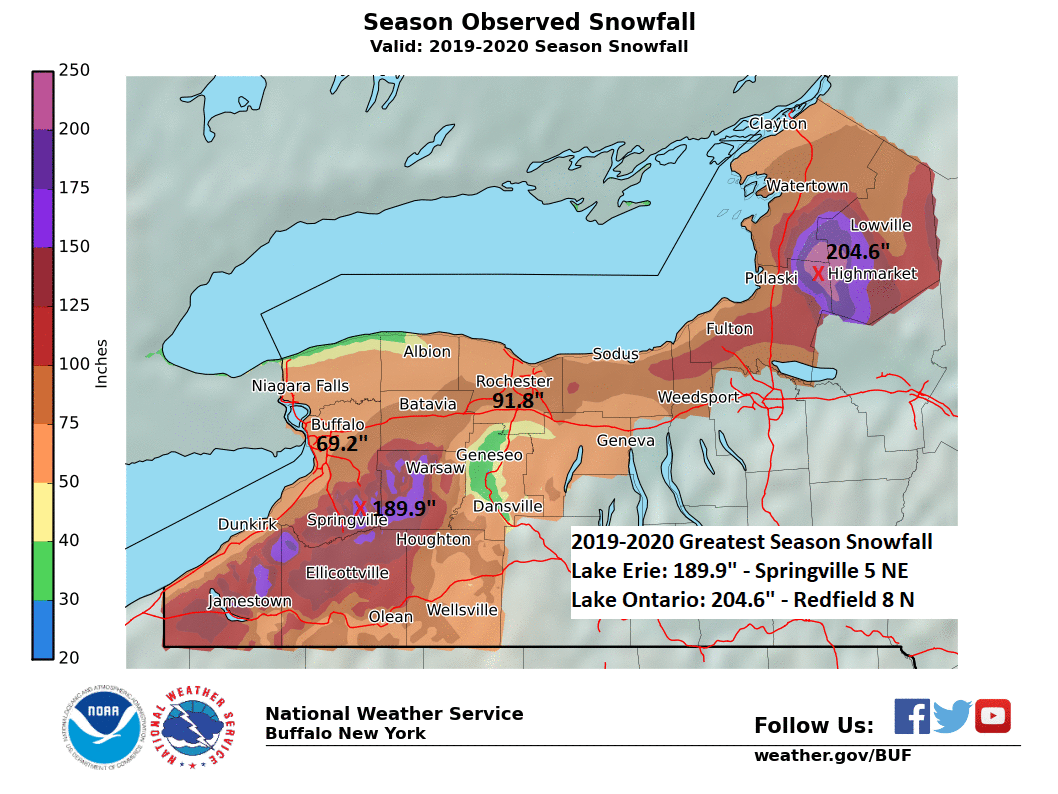
Winter Summary 2019-2020 The winter of 2019-20 was relatively quiet, with few lake effect events – of which many produced around a foot or less of snow, few synoptic snow events, and temperatures that averaged above normal during the heart of winter. This winter was bracketed by an early widespread heavy snow event over Veterans Day, and late season May snow, which for several climate locations was the first measurable snow in May in several decades. In between the early and late season snow, lake effect and synoptic snow events were few with the only notable snow event of the winter season occurring the last days of February and into the first few hours of March. This event brought blizzard conditions and up to four feet of snow east of Lake Ontario. East of Lake Erie the still open waters produced lake effect snow, but not as intense or deep as what occurred east of Lake Ontario. Significant plumes of lake effect snow struggled to form this month within the prolonged mildness through the winter months. There were just 7 events (defined as producing 7” or more snowfall downwind of either Lake Erie or Lake Ontario) and 6 of these events were rather weak, yielding around a foot or less of snowfall. There was one blizzard, with this during the February 27th to March 1st lake effect event east of Lake Ontario. The mild winter brought little ice cover to area streams and creeks. As a result there were no ice jam flooding issues this winter. Additionally most rivers remained in their banks during early spring rains and snowmelt, and the only river flooding of the winter season was within the Black River basin and this came in early November. For the 8th time on record, and 3rd time in the past 5 winters Lake Erie did not freeze over. There was one day when the water temperature did dip to 32°F, but this was not long enough for ice formation over the entire Lake, and the Lake was thus deemed not ice covered. Snowfall The winter season started early for Western and North Central New York. A surface low tracked across Pennsylvania and eastern New York and spread 6 to 12 inches of snow across the region on Monday, November 11th and Tuesday November 12th . Climate snowfall records were set at both Buffalo (8.7” on November 11th ) and Rochester (8.2” on November 11th and 5.8” on November 12th ). After an initial synoptic snow event mid-November, it would be quite a bit later before the first significant lake effect snow event occurred. It took until December 18th before lake effect snow piled over a half a foot and this is the 2 nd latest start to the lake effect snow season. The latest start is the winter season of 2001-02 whose first significant lake effect snow event did not occur until December 20th. In total there were 2 lake effect snow events in December, 3 in January and the final 2 lake effect snow events of the winter season occurred in the month of February. While the heart of winter featured below normal snowfall, late season coldness returned through April and lasted into the first half of May. This brought late season snow showers through the April month and even into the first half of May, with some locations measuring their first May snow in several decades. Combined synoptic and lake effect snow totaled below normal for our region, with just the Upper Genesee Valley featuring above normal snowfall. Temperatures Dips in the jetstream encouraging periods of below normal temperatures occurred mainly outside the three main winter months of December, January and February. The month of November featured many days with below normal temperatures of which most occurred in the first 3 weeks. The first widespread large snow event of the winter season also came with record breaking coldness, with record low temperatures established at virtually all climate sites. Watertown N.Y. set a new monthly record low temperature of -7°F on the 13th of November. The Jetstream flattened during the heart of winter, with above normal temperatures from December through March. However towards mid-April the last of winter’s coldness crept back across the Great Lakes region. An unseasonably cold airmass entrenched over the Great Lakes through much of the remainder of April and even into the first half of May. Winter Statistics for Buffalo and Rochester Buffalo Rochester Monthly Highlights November November started cold, and remained cold through much of the month. It was a very windy start, as the Halloween wind event carried over into the first few hours of November with numerous power outages across the region. The southwest winds also pushed a seiche on Lake Erie to just over 10.5 feet in the first hour of the month, which produced damage along the coastline from Dunkirk to Buffalo. Cold air behind a cold front brought the average temperature for the 1st to below normal and this below normal temperature trend continued for the next 3 weeks. A plunge of polar air mid-month brought extreme November cold temperatures, with both the 12th and 13th setting record low temperatures across the region. This fresh arctic air also set the stage for an early season widespread snow event across Western and North Central New York. On nearly a foot-magnitude scale, this snow event was one of the earliest widespread snow events for the region on record. As below normal temperatures continued, the snowpack remained across the area for a 7 to 10 day period. A minor wind event occurred on the 22nd as a surface low deepened across Eastern Canada. A more widespread wind event occurred on the 27th as a deep surface low tracked just to the west and north of Western New York, and sent winds gusting to 59 mph at the Buffalo airport. In addition to tree damage and localized power outages in Western New York, another seiche on Lake Erie occurred for the month, with water rises on this event up to near 9.5 feet above low water datum. The last 10 days of the month also were not nearly as cold as the start of the month, and included a day in the 60s on the 27th. While snow hampered mid-month outdoor work, a relatively dry and mild end to the month allowed for late autumn outdoor work to be completed. December December started cool and wet with measurable precipitation many of the first 10 days of the month. Temperatures were also fairly consistent the first week of the month. Marginally cold air to support lake effect snow crossed the Great Lakes on the 4th. This brought a plume of extremely heavy wet snow to areas near the Buffalo airport. Less than half a foot of snow fell from this snow band, though overall melted equivalent totaled over an inch. East of Lake Ontario four to six inches of snow fell across the Southern Tug Hill region. Another minor, but impactful lake effect snow event occurred on the 10th through the 11th of the month. This featured a band of snow that started in the Southern Tier late on the 10th behind a cold front. The snow band lifted northward to the Buffalo Southtowns during the morning commute on the 11th. The snow band then lifted all the way to near the Lake Ontario shoreline midday before dropping back across the Buffalo Metro area during the late afternoon and evening commute. Though snow totals were again generally around half a foot or less, there were major travel impacts during the busy commutes. Lake effect snow also fell east of Lake Ontario, with greatest accumulation near the Tug Hill of 4 to 5 inches. A synoptic system passed across the eastern portion of our state on the 14th and 15th and brought rain that ended with a few inches of snow across lower elevations, but across the higher terrain around a half a foot of snow fell. After a brief break from the precipitation later on Sunday the 15th and into Monday the 16th, another synoptic system brought snow inland across Western New York and the Finger Lakes and eastern Lake Ontario region late on the 16th and 17th of the month. This system drew much colder air southward across the Eastern Great Lakes such that the first significant lake effect snow event occurred on the 17th and 18th of the month. A band of lake effect snow produced just over a foot of snow across the Ski Country and Southern Tier of WNY, while east of Lake Ontario just over a foot of snow fell, centered upon the southern Tug Hill region. Typically the first significant lake effect event occurs on average about a month earlier. The final 10 days of the month were unusually quiet as a mild airmass lingered over the Eastern Great Lakes. This produced a bare ground for much of our region, including over the Christmas holiday season. There were a few nights with dense fog over parts of the region just past Christmas. A snow squall along a cold front crossed western New York midday on the 31st, bringing just a few tenths of an inch of snow, but brief gusty winds and near white out conditions. After the passage of a cold front the stage for the second significant lake effect snow event of the year in the starting in the final hours of December. January The mild month of January was uneventful with lake effect snow events lacking in intensity. After several marginally significant lake effect snow events early in the month, a combination synoptic and lake effect snow event over the end of Martin Luther King Jr. holiday weekend (January 18th-19th) brought a foot and a half of snow to the hills of SW NYS, and 4 to 6 inches of snow across the Metro Buffalo area and southeast of Lake Ontario. The other notable weather event of the month was a high wind event following a cold front passage. Early on Sunday, January 12th, a cold front passed across Western New York. Behind the front southwesterly winds rapidly increased and a gust of 69 mph was measured at the Buffalo airport, and 63 mph at the Rochester airport. Numerous trees fell across Western New York, with scattered power outages. These strong winds also produced a seiche on Lake Erie, with the lake rising to 9 feet, 10 inches above low water datum. A second seiche, this at 8 feet, 2 inches above low water datum occurred on the 18th under strong southwest winds, though gusts were not of the magnitude as the event 6 days earlier. February February was a quiet month overall, though most of the climate reporting stations (Airport and Cooperative Observers) across Western New York and North Central New York reported above normal snowfall. There were several marginal set-ups for snow early in the month, most of which were of the lake effect snow variety. A storm system approached our region on the 6th of February, with a few inches to half a foot of snow, and precipitation then ending as a light icing event. Upwards to a quarter of an inch of ice formed on the 6th . This system eventually deepened rapidly off the New England coastline on the 7th , bringing back colder air along with accumulating snow. The snow across Western New York amounted to just a few inches to half foot for higher elevations, however, upwards to a foot of snow fell east of Lake Ontario. Behind an arctic front on the 13th and 14th weak lake effect snow generated off the eastern Great Lakes with just a few inches across lower elevations east of the Lakes, and a half a foot of snow across the higher terrain. A storm system passed across the region on the 18th as mainly rain, and a few wet snowflakes near Buffalo, but to the east and across Metro Rochester a wet snow accumulated several inches with major impacts during the morning rush hour commute. The significant event this month occurred late with a prolonged flow of colder air over the still open eastern Great Lakes generating a plume of lake effect snow. A combination of synoptic and lake effect snow late on the 26th and 27th amounted to just a few inches of snow around Buffalo and Rochester, but across the hills south of Buffalo one to two feet of snow fell. Even greater amounts of snow fell east of Lake Ontario where 4 feet of snow fell across portions of Jefferson and Lewis Counties. Additionally strong westerly winds brought blizzard conditions across the higher terrain on Thursday the 27th and Friday the 28th. This would be the most impactful lake effect snow event this winter season, and also was the last significant lake effect snow event of the winter season. March On the heels of a tame winter, the start of meteorological spring was quiet, this for a month that can have much active weather. Every climate reporting station (Airports and Cooperative Observers) reported below normal snowfall this month. The only storm system of note for the month was March 20th, when a wind storm brought strong winds across Western New York with isolated wind damage. The one minor snow event this month occurred on the 23rd with up to a half a foot of snow falling southeast and east of Lake Ontario. It was a mild month, with the warmth peaking on the 29th and supporting the first widespread severe thunderstorm event of the spring season. April After four months of above normal temperatures, a pattern change occurred the second week in April, with below normal temperatures dominating the region through the end of the month. On the leading edge of this change to cooler weather was a complex of thunderstorms that clipped southwestern New York State. These storms brought strong winds and hail to the Western Southern Tier late on the 7th. Thereafter and with an upper level trough lingering over the Northeast and providing a cool airmass, periods of mainly light snow showers fell from time to time through the month. There was one major synoptic system this month, on the 13th an area of low pressure tracked just to the north of the region, spreading a half to one inch of rainfall across the region, while behind a pair of cold fronts strong gusty winds swept across the region. Peak wind gusts on the 13th included 56 mph at the Buffalo airport, and 51 mph at both the Rochester and Watertown airports. May Cool weather continued into the first few weeks of May, and brought several days with snow showers. While minor, there were several tenths of an inch of snow falling during the second week in May. It was also this second week that several record cold temperatures were recorded, including sub-freezing lows at both Buffalo and Rochester. By the third week of the month temperatures warmed into the 60s and the region was well on its way to late month 90s that put winter at a distance in the rear view mirror. |

