National Weather Service United States Department of Commerce

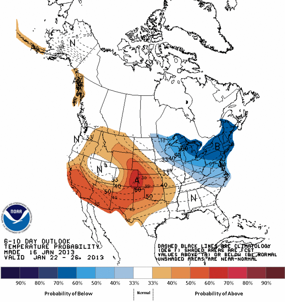
Cold air will rush into the region Saturday night behind a strong cold front and stay in place through at least mid-week.  It will be breezy from Saturday through Sunday night (with Sunday downright blustery!) making it feel much colder. 

For most of the area this system will not bring a lot of precipitation with it, but lake effect snow is possible for the snowbelt. There is still uncertainty with respect to the potential snowfall from lake effect.  While the temperatures aloft will certainly be cold enough for the lake effect, there is uncertainty as to how much moisture will be with this system.  Typically an arctic airmass like this is accompanied by rather dry air which is not good for prime lake effect.

The temperature outlook (at right) shows below normal temperatures for the Great Lakes to New England from January 22nd - 26th.

Saturday Night: The cold front arrives Saturday night bringing the      start of the coldest air of the season so far. Winds will pick up and it will be breezy.

Sunday           : Little temperature recovery, if any.  It will be very windy making if feel even colder.

Sunday Night  : Continued breezy and cold.

Temperature Outlook
NWS Wind Chill Chart & Calculator
hourly weather graph   Day 3-7 U.S. Hazard Outlook
Upcoming National Hazards
Toledo Cleveland Findlay Mansfield
Canton Youngstown Erie, PA Other Cities

The last time the hgih temperature did not reach 20 degrees was: 


Cleveland                                          February 10, 2011

Toledo                                                January 20, 2012

Mansfield                                           January 14, 2012

Akron-Canton                                   February 10, 2011

Youngstown                                      February 10, 2011

Erie, PA                                            February 10, 2011


Upcoming High and Low Temperatures


Sunday

Sunday Night

Max Temperature 1/20/13

Min Temperature 1/21/13

Monday

Monday Night

Max Temperature 1/21/13 Min Temperature 1/22/13

Tuesday High

Tuesday Low

Max Temperature 1/22/13 Min  Temperature 1/23/13


474
FLUS41 KCLE 140811
HWOCLE

Hazardous Weather Outlook
National Weather Service Cleveland OH
311 AM EST Wed Jan 14 2026

OHZ011>014-089-151000-
Cuyahoga-Lake-Geauga-Ashtabula Inland-Ashtabula Lakeshore-
311 AM EST Wed Jan 14 2026

...WINTER WEATHER ADVISORY NOW IN EFFECT FROM 11 AM THIS MORNING TO
7 PM EST THURSDAY...

This Hazardous Weather Outlook is for northeast Ohio.

.DAY ONE...Today and tonight.

Please listen to NOAA Weather Radio or go to weather.gov on the
Internet for more information about the following hazards.

Winter Weather Advisory.

Cold air and elevated northwest winds are expected behind a cold
front tonight with lows in the teens and wind chills near zero.

.DAYS TWO THROUGH SEVEN...Thursday through Tuesday.

Please listen to NOAA Weather Radio or go to weather.gov on the
Internet for more information about the following hazards.

Winter Weather Advisory.

A series of cold low pressure systems will enter for the weekend
into next week. Low temperatures in the single digits and wind chills
below zero are possible daily through Tuesday. Additional chances for
accumulating snowfall also exist in NE OH.

.SPOTTER INFORMATION STATEMENT...

Spotter activation is not expected at this time.

$$

PAZ002-151000-
Southern Erie-
311 AM EST Wed Jan 14 2026

...LAKE EFFECT SNOW WARNING IN EFFECT FROM 11 AM THIS MORNING TO
1 AM EST FRIDAY...

This Hazardous Weather Outlook is for northwest Pennsylvania.

.DAY ONE...Today and tonight.

Please listen to NOAA Weather Radio or go to weather.gov on the
Internet for more information about the following hazards.

Lake Effect Snow Warning.

Cold air and elevated northwest winds are expected behind a cold
front tonight with lows in the teens and wind chills near zero.

.DAYS TWO THROUGH SEVEN...Thursday through Tuesday.

Please listen to NOAA Weather Radio or go to weather.gov on the
Internet for more information about the following hazards.

Lake Effect Snow Warning.

A series of cold low pressure systems will enter for the weekend
into next week. Low temperatures in the single digits and wind chills
below zero are possible daily through Tuesday. Additional chances for
accumulating snowfall also exist in NW PA.

.SPOTTER INFORMATION STATEMENT...

Spotter activation is not expected at this time.

$$

PAZ001-003-151000-
Northern Erie-Crawford-
311 AM EST Wed Jan 14 2026

...WINTER WEATHER ADVISORY REMAINS IN EFFECT FROM 11 AM THIS MORNING
TO 1 AM EST FRIDAY...

This Hazardous Weather Outlook is for northwest Pennsylvania.

.DAY ONE...Today and tonight.

Please listen to NOAA Weather Radio or go to weather.gov on the
Internet for more information about the following hazards.

Winter Weather Advisory.

Cold air and elevated northwest winds are expected behind a cold
front tonight with lows in the teens and wind chills near zero.

.DAYS TWO THROUGH SEVEN...Thursday through Tuesday.

Please listen to NOAA Weather Radio or go to weather.gov on the
Internet for more information about the following hazards.

Winter Weather Advisory.

A series of cold low pressure systems will enter for the weekend
into next week. Low temperatures in the single digits and wind chills
below zero are possible daily through Tuesday. Additional chances for
accumulating snowfall also exist in NW PA.

.SPOTTER INFORMATION STATEMENT...

Spotter activation is not expected at this time.

$$

OHZ003-006>010-017>023-027>033-036>038-047-151000-
Lucas-Wood-Ottawa-Sandusky-Erie-Lorain-Hancock-Seneca-Huron-Medina-
Summit-Portage-Trumbull-Wyandot-Crawford-Richland-Ashland-Wayne-
Stark-Mahoning-Marion-Morrow-Holmes-Knox-
311 AM EST Wed Jan 14 2026

This Hazardous Weather Outlook is for north central Ohio, northeast
Ohio and northwest Ohio.

.DAY ONE...Today and tonight.

A strong cold front will enter on this afternoon, quickly changing
rain to snow. A quick inch to inch of snow is possible during the
evening commute and may cause hazardous travel conditions.

Cold air and elevated northwest winds are expected behind this front
tonight with lows in the teens and wind chills near zero.

.DAYS TWO THROUGH SEVEN...Thursday through Tuesday.

A series of cold low pressure systems will enter for the weekend
into next week. Low temperatures in the single digits and wind chills
below zero are possible daily through Tuesday.

.SPOTTER INFORMATION STATEMENT...

Spotter activation is not expected at this time.

$$

LEZ061-142>149-162>169-151000-
Ripley to Buffalo NY extending from 5NM off shoreline to US-
Canadian border-Maumee Bay to Reno Beach OH-
Reno Beach to The Islands OH-The Islands to Vermilion OH-
Vermilion to Avon Point OH-Avon Point to Willowick OH-
Willowick to Geneva-on-the Lake OH-Geneva-on-the-Lake to Conneaut OH-
Conneaut OH to Ripley NY-
Detroit River Lt. to Maumee Bay OH to Reno Beach OH beyond 5NM
offshoreline to US-Canadian border-
Reno Beach to The Islands OH beyond 5NM off shoreline to US-
Canadian border-
The Islands to Vermilion OH beyond 5 nm off shoreline to US-
Canadian border-
Vermilion to Avon Point OH beyond 5 nm off shoreline to US-
Canadian border-
Avon Point to Willowick OH beyond 5 nm off shoreline to US-
Canadian border-Willowick to Geneva-on-the-
Lake OH beyond 5NM off shoreline to US-Canadian border-Geneva-on-the-
Lake to Conneaut OH beyond 5 nm off shoreline to US-Canadian border-
Conneaut OH to Ripley NY beyond 5 nm off shoreline to US-
Canadian border-
311 AM EST Wed Jan 14 2026

This Hazardous Weather Outlook is for Lake Erie.

.DAY ONE...Today and tonight.

No hazardous weather is expected at this time.

.DAYS TWO THROUGH SEVEN...Thursday through Tuesday.

No hazardous weather is expected at this time.

.SPOTTER INFORMATION STATEMENT...

Spotter activation is not expected at this time.

$$