Nearby National Weather Service Radars |
|||
 |
 |
 |
 |
| Chicago, IL | Indianapolis, IN | Fort Wayne, IN | Detroit, MI |
 |
 |
 |
 |
| Wilmington, OH | Pittsburgh, PA | Buffalo, NY | Charleston, WV |
 These images are just as they sound as they paint a picture of the weather from the energy reflected back to the radar. There are two types available on the web; Base (or ½° elevation) reflectivity and Composite reflectivity.
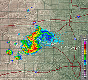
Base Reflectivity is the default image. Taken from the lowest (½° elevation) slice, it is the primary image used to "see what's out there". There are two versions of Base Reflectivity image; the short range version which extends out to 124 nm (about 143 miles) and the long range version which extends out to 248 nm (about 286 miles). This image is available upon completion of the ½° elevation scan during each volume scan. View a sample base reflectivity image.
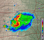
Composite Reflectivity images utilize all elevation scans during each volume scan to create the image. It is composed of the greatest echo intensity (reflectivity) from any elevation angle seen from the radar. It is used to reveal the highest reflectivity in all echoes. View a sample composite reflectivity image (scroll down).
 One of the best features on the 88d Doppler radar is its ability to detect motion. However, the only motion it can "see" is either directly toward or away from the radar. This is called radial velocity as it is the component of the target's motion that is along the direction of the radar beam.
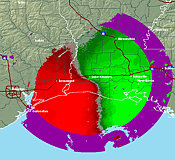
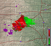
In all velocity images, red colors indicate wind moving away from the radar with green colors representing wind moving toward the radar. It is very important to know where the radar is located as that is your reference point for proper interpolation of the wind's motion.
Base Velocity images provides a picture of the basic wind field from the ½° elevation scan. It is useful for determining areas of strong wind from downbursts or detecting the speed of cold fronts. However, since the radar only measures radial velocity, the strength of the wind will always be less than what is actually occurring unless the wind is moving directly toward or away from the radar.
 Also, the surface winds are only for areas near the radar. As distance increases from the radar, the reported value will be for increasing heights above the earth's surface. View sample base velocity image.
Storm Relative Motion images are very useful images to look for small scale circulations (called mesocyclones) in thunderstorms. Often, these small scale circulations are areas where tornadoes form.
What separates storm relative motion from base velocity is the motion of storms are "subtracted" from the overall flow of the wind. As storms move, their own motion can mask circulations within themselves. This motion is removed to make the view of the wind relative to the storm. In effect, what is seen is the wind's motion as if the storms were stationary. View a sample Storm Relative Motion image (scroll down).
More information: NWS JetStream - Online School for Weather (Doppler Radar)
 National Weather Service radars provide forecasters information on precipitation intensity and movement (direction and speed). Dual polarization technology adds new information about the size and shape of an object, which will improve estimates of how much rain is falling, improving flash flood detection and warnings. During winter weather, dual polarization radar can tell the difference between rain, snow and ice, which gives forecasters a much better idea of what to expect at the ground. Additional information:
The NWS Cleveland WSR-88D Doppler Weather Radar, KCLE, was recently upgraded. With this upgrade, the KCLE radar began participation in a field test of the Multiple Elevation Scan Option (MESO) for SAILS (Supplemental Addaptive Intra-Volume Scan). The field test will continue for about 1 year. The SAILS function allows for one addtional low level scan (0.5 degree elevation angle) per volume scan. MESO-SAILS enables the radar operator to select either 1, 2, or 3, supplemental low level scans per volume scan. This new scan is inserted into the “middle” of the volume scan to evenly space, as close as possible, the time intervals between low-level data updates. When the MESO-SAILS 3 Scan Option is active, the 0.5 degree updates will be available every 75 to 90 seconds. SAILS as well as MESO-SAILS is only available when the radar is in VCP (Volume Coverage Pattern) 12 or 212.
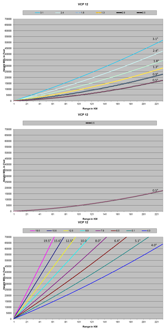
The regular SAILS option begins the scan strategy at elevation 0.5 and advances upward to 3.1 (first chart on the left). It then returns to swipe an addiitonal 0.5 scan (second second chart) before returning to complete (third chart) the rest of the elevations (4.0 to 19.5, for example).
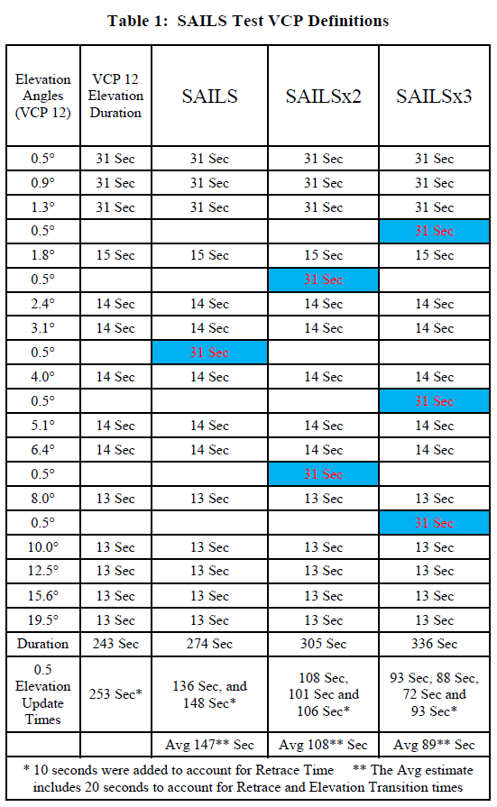 The table on the left shows the elevation scan pattern that can be expected when in SAILS (exactly like the above description) and for the additional SAILSX2 and SAILSX3 options. It also shows the amount of time to comple each scan.
The first SAILS (additional) scan takes place after the 3.1 scan for SAILS, after the 1.8 scan for SAILSX2, and after the 1.3 scan for SAILSX3. The SAILSX2 and SAILSX3 get additional 0.5 scans after the 6.4 slice and 4.0 slice, respectively. The final additional 0.5 scan of SAILSX3 takes place after the 8.0 scan.
|
The primary advantage to utilizing this feature is to get more frequent scans of the lowest elevation in order to interrogate critical features such as possible rotation and tornado formation (among other storm-scale features). |

