By: Brian Astifan, NWS Cleveland Service Hydrologist in 2006
Sarah Jamison, NWS Cleveland Service Hydrologist since 2010
Beginning with the extreme flood of late June, northern Ohio and northwestern Pennsylvania entered an unusually active flash flood season that lasted through the month of July. Two consecutive days of heavy thunderstorms in late June brought the worst flooding many areas in northern Ohio had seen in nearly 40 years. When all was done six counties in Ohio (Cuyahoga, Erie, Huron, Lucas, Sandusky, and Stark) had been declared major disaster areas. Periods of torrential rains continued into July. In a little more than 5 weeks, at least 6 major flash flood events took place across the area. Three flood-related fatalities were reported during the month, and damage to homes and infrastructure totaled in the hundreds of millions.
June 21-22, 2006 -- Cuyahoga, Erie, Huron, Lucas, Sandusky, and Stark Counties
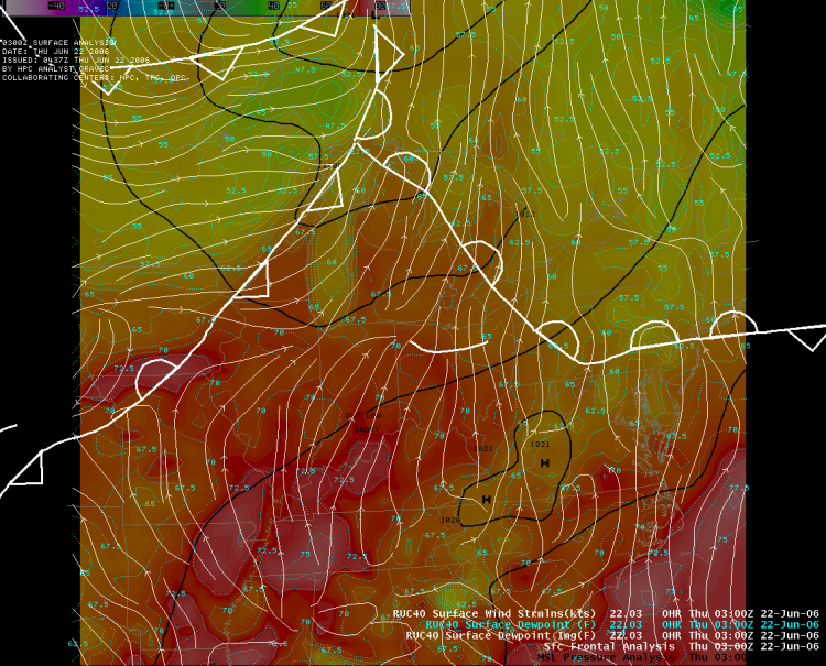
A warm front lifted north across the lower Great Lakes Region on the 21st, drawing deep tropical moisture northward into Ohio. Thunderstorms formed along this front during the late afternoon hours and evolved into a nocturnal Mesoscale Convective Complex (MCC) that remained nearly stationary over northwest and north central Ohio until the early morning hours of the 22nd, bringing intense rainfall, flash floods, and widespread severe weather. The following afternoon a cold front moved towards the area, triggering a second round of severe weather and flooding. When the rainfall finally ended early on the 23rd, a new record flood had been established on the Cuyahoga River and three separate tornado touchdowns had been confirmed in Holmes and Stark counties. Elsewhere across northern Ohio, widespread straight line wind damage downed many trees and power lines, and several buildings sustained structural damage.
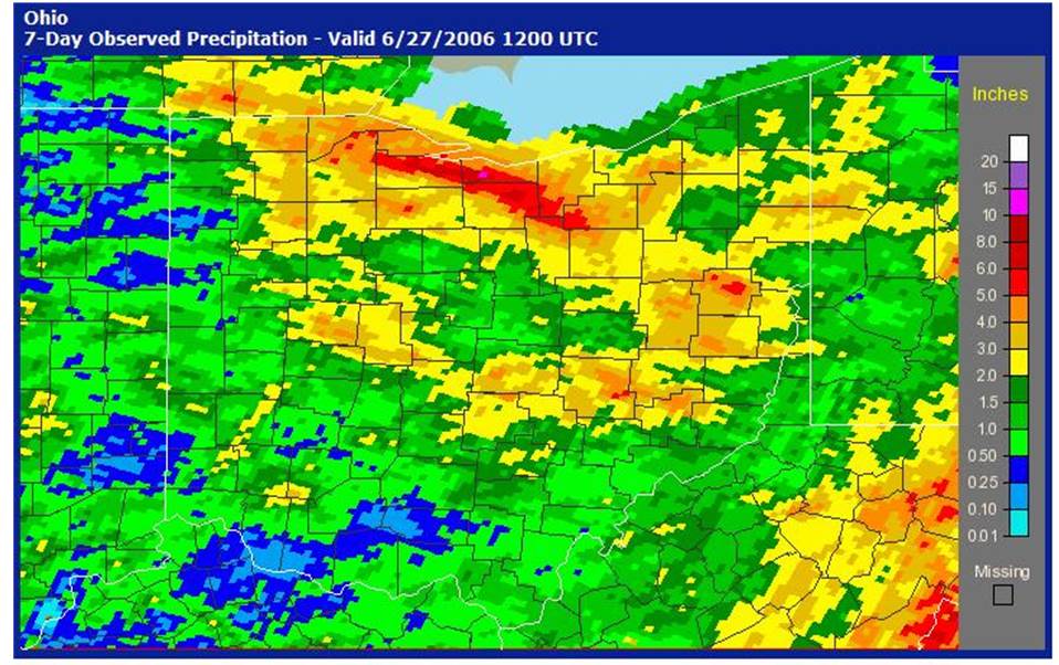
Figure 1: Radar estimated rainfall for June 20 through June 27, 2006. Pink areas denote rainfall estimates of 10 inches or more.
| Frame Controls: |
|
Loop Mode: 
Animate Frames:   
Dwell First:   Dwell Last:  
Adjust Speed:  
Advance One:  
|
|
| Original Javascript by Robert.Rozumalski@noaa.gov. |
Figure 2: Surface Front Evolution from June 21-22, 2006.
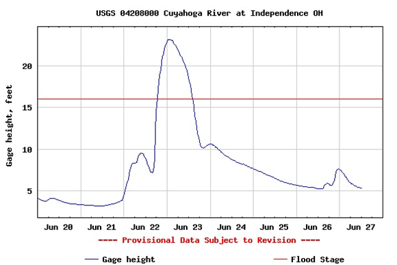
Figure 3: Hydrograph showing the river stage from June 20-27, 2006 from the USGS river gauge in Independence, Ohio.
The storm complex which developed over northern Ohio on the 21st brought torrential rainfall in excess of 6 inches in 6 hours across much of northwest and north central Ohio between Lucas County (Toledo Area) and Ashland County (60 miles southwest of Cleveland). Major urban flooding was reported in Sylvania and Toledo in Lucas County when ditches and small streams were overwhelmed by the heavy rainfall. Primary and secondary roads throughout the region were impassable, and many water rescues and evacuations took place. Flooding across this area was by far the worst since 1969, when up to 14 inches of rain fell along a similar axis across northern Ohio. Norwalk was particularly hard hit, with over 800 homes flooded or evacuated overnight and the city divided in half by overflow from the Norwalk Reservoir. Water levels behind the reservoir reached levels not seen since 1969 flood, when the dam failed and caused catastrophic damage downstream.
Downstream from Norwalk, the Huron River at Milan (Erie County) rose to its third highest crest on record, at 23.95 feet. The next major river to the east, the Vermilion River at Vermilion, while not having a top ten crest, did have its third highest flow on record. The tremendous amount of water flowing down the Vermilion River washed docks and boats into Lake Erie from their moorings in downtown Vermilion. In the town of Sandusky, scores of residents were quickly evacuated during the morning hours of the 23rd when Pipe Creek rapidly rose and flooded several residential areas.
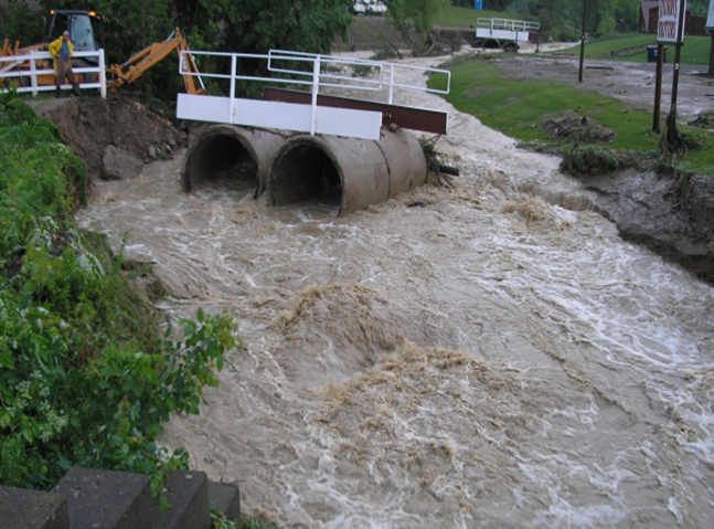
The following afternoon intense, nearly stationary thunderstorms developed along weak outflow boundaries over Cuyahoga and Summit Counties. 5 to 6 inches of rain fell in less than 2 hours across several southern Cleveland suburbs, with Brecksville recording an incredible 1.64 inches in 15 minutes and 3.38 inches in an hour. Streams and sewer systems were overwhelmed by the runoff, and only 8 hours later the Cuyahoga River at Independence crested at a new record high of 23.33 feet, breaking the previous record of 22.41 feet, set in 1959. According to the Cleveland Plain Dealer, over 4000 homes in Cuyahoga County alone sustained flood damage that afternoon. Damage estimates for the two days of flooding exceed 150 million dollars. The only fatality during the flood was a tragic one, as a rescue diver was overwhelmed by flood waters while trying to reach and save two teens who had driven into a flooded roadway in southern Lorain County during the morning of the 22nd.
Notable 2 day precipitation totals across northern Ohio:
Lucas Co - University of Toledo 7.25 (fell in 8 hours)
Huron Co - Southern Norwalk 6.66 (fell in 11 hours)
Erie Co - Vermilion 6.50 (fell in 12 hours)
Huron Co - Norwalk WWTP 5.74
Cuyahoga Co - Solon 5.60
Summit Co - Twinsburg 5.34
Huron Co - Fitchville 5.30
Lucas Co - West Toledo 5.15
Erie Co - Finday State Park 5.12
July 10, 2006 -- Ashland, Knox, Richland, and Holmes Counties
Widespread thunderstorms fired during the afternoon of July 10th along and near a stationary front which was oriented east-west across the REGION. In the midst of the line of thunderstorms a supercell developed and moved south through Ashland county, before becoming nearly stationary near the Ashland/Richland/Knox county border just south of Loudonville. The storm produced a tornado in southern Richland and Ashland counties, as well as torrential rainfall and flash flooding. Up to 7.5 inches of rain fell in a 2 hour period along the adjoining borders of the four counties. The area hardest hit by the flash flooding is a popular recreation area, and many rescues and evacuations took place as campgrounds were quickly submerged by the rising river waters. Up to 700 people were evacuated from Mohican State Park alone, most by boat. Dozens of roads were closed, and at least 15 roads in the area were washed out or sustained significant damage.
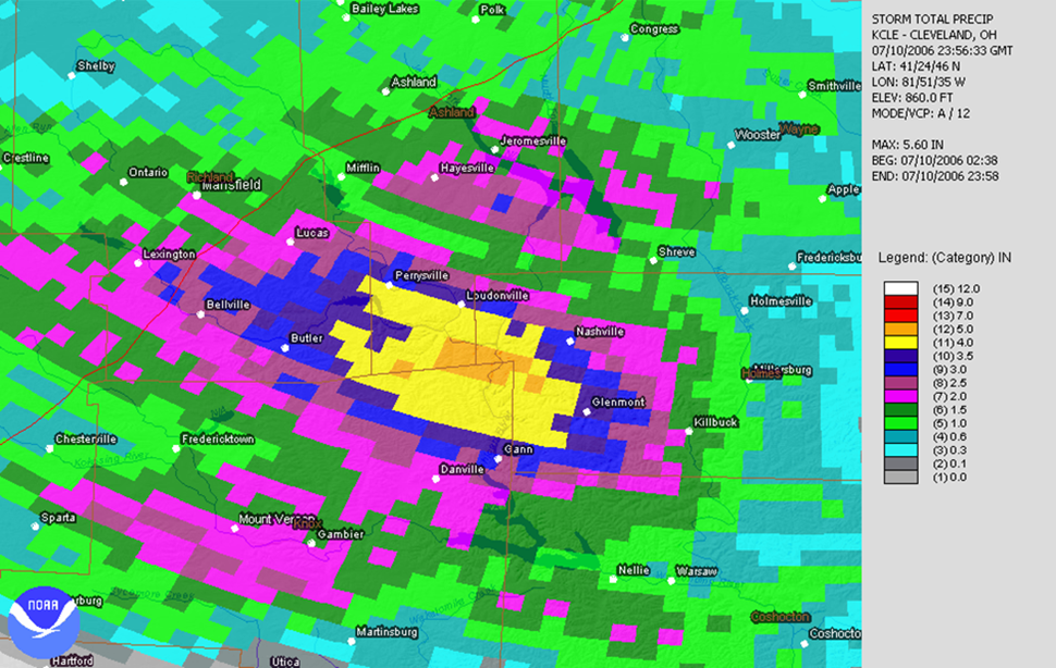
Figure 4: Radar estimated rainfall for the Mohican River Valley for July 10, 2006. Orange area denote rainfall estimates of 5 inches or more.
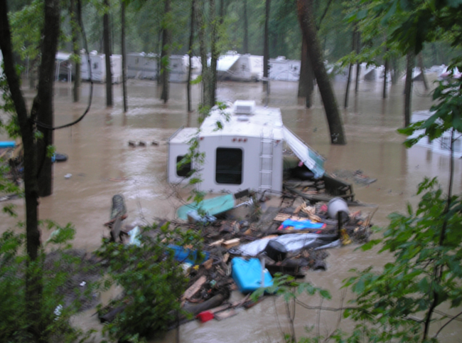
Photos of flood water in trailer parks along the Mohican River in Loudonville on July 10, 2006. Photos courtesy of Ashland and Richland County EMAs.
July 12, 2006 -- Richland, Ashland, Marion, Morrow, Knox, Wyandot, and Crawford Counties
In the two days following the Loudonville flood, deep tropical moisture increased across northern Ohio, setting the stage for another round of flooding on the 12th. Thunderstorms developed along the same frontal boundary responsible for the flooding on the 10th, slowly moving south and stalling near US 30. With soils still wet from the heavy rains earlier in the week, flash flooding developed quickly, flooding dozens of roads and homes. Significant urban flooding took place in Mansfield, where a woman tragically died attempting to rescue her daughter after the girl fell into a flooded ditch and was swept through a culvert. Even with the axis of heavy rainfall further west, campgrounds near Loudonville saw river levels exceed those seen on the 10th as runoff from the Mansfield area drained southeast into the Mohican River. Water levels were slow to recede in the relatively flat terrain; during the early morning hours of the 14th a man drove his pickup into the flooded Tymotchee Creek in western Wyandot County and perished when his vehicle was swept downstream.
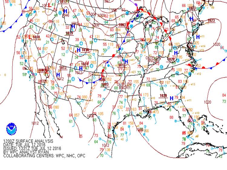
Figure 5: NWS Weather Map for July 12, 2006. The warm front in northeast Ohio became a quasi-stationary front and lingered over central Ohio.
July 22, 2006 -- Ashtabula and Lake Counties
During the early morning hours of the 22nd, a lake enhanced area of thunderstorms formed along the lakeshore of Ashtabula and Lake counties, producing torrential rainfall rates. Even with little thunder and no severe weather, this band of showers fed off the extremely warm waters of Lake Erie and produced up to 7.2 inches of rain in about a 3 hour period in the city of Ashtabula. Extensive flooding resulted in the communities along the lakeshore north of Interstate 90, with several people evacuated from homes and at least one person rescued from a stranded vehicle. Over 100 homes were damaged by the flooding, with several roads washed out in Saybrook and Ashtabula Townships.
July 27-28, 2006 -- Lake, Cuyahoga, Ashtabula, Geauga, and Crawford (PA) Counties
This was arguably the most dramatic flood event of the summer, as a widespread area of 6 to 10 inches of rain fell over all of Lake County (and adjacent portions of Cuyahoga, Geauga, and Ashtabula counties), leading to unprecedented flooding in the area and a new record crest on the Grand River at Painesville. A first round of showers and thunderstorms formed over Lake Erie during the afternoon of the 27th and dumped 3 to 5 inches of rain in Lake and eastern Cuyahoga counties. Light rain continued throughout the evening, but a second round of very heavy rainfall that moved in off the lake after midnight brought another 3 to 5 inches of rain and quickly escalated the flash flooding in Lake County to catastrophic levels.
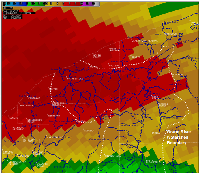
Figure 6: Radar estimated rainfall for Lake and Ashtabula Counties from July 27-28, 2006. Red areas denote rainfall estimates of 5-10 inches.
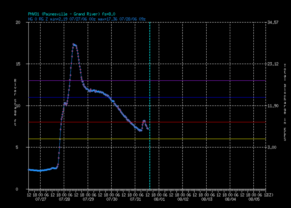
Figure 7: River stage level at the USGS river gauge in Painesville, Ohio.
Action, Minor, Moderate, and Major flood stages denoted in yellow, red, blue, and purple respectively.
Thousands of homes were damaged and hundreds of people were evacuated during the middle of the night by boat, helicopter, and even front-end loaders. The Grand River rose from a stage near 2 feet on the morning of the 26th to a record crest of 17.36 feet around 5 am on the 28th, breaking the old record of 13.1 feet set in 1979. Approximately 100 homes were destroyed in the county, with another 800 significantly damaged. 5 bridges were completely washed away in the county, with dozens of roads damaged by erosion and mudslides. This event has been classified as a 500 year flood event by the USGS.
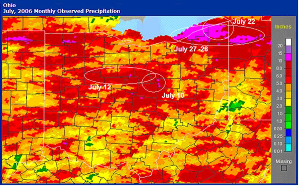
Figure 8: Radar estimated rainfall for the month of July 2006. Pink areas denote rainfall estimates of 10 inches or more.
Complete Event Summary:
Late June through much of July was an unusually active, wet period across northern Ohio. A deep tropical airmass that moved into the region in late June remained more or less entrenched over the area through the end of July. Listed here are the most significant flash flood event to have occurred in northern Ohio during that time, as the abundant moisture and weak upper air flow provided an environment conducive to heavy rainfall. Fifty flash flood warnings were issued by WFO Cleveland in June and July alone, and a new river level record was established on the Grand River at Painesville and the Cuyahoga River at Independence. This was the most flood prone July on record, and the most active 6 week period for flash flood events for northern Ohio.
Additional Information and References:
For more information on these floods please see the USGS Scientific Investigations on the floods:
Flood of July 27–31, 2006, on the Grand River near Painesville, Ohio
Regional Rainfall Totals from June 20-July 28, 2006:
|
Station Name |
County |
Precipitation (inches) |
Departure |
1-Day Max |
Date of Max |
|
Chardon |
Geauga |
17.57 |
12.13 |
5.5 |
2006-07-28 |
|
Painesville 4 NW |
Lake |
17.16 |
12.51 |
4.57 |
2006-07-28 |
|
Kirtland-Holden 2 |
Lake |
16.53 |
11.21 |
6.89 |
2006-07-28 |
|
Greer |
Knox |
15.68 |
10.15 |
6.62 |
2006-07-11 |
|
Galion Wtr Wks |
Crawford (OH) |
13.85 |
7.94 |
4.4 |
2006-07-13 |
|
Mansfield 5 W |
Richland |
13.21 |
8.21 |
2.55 |
2006-07-12 |
|
Warren 3 S |
Trumbull |
12.52 |
6.87 |
2.26 |
2006-06-23 |
|
Toledo Express Airport |
Lucas |
12.47 |
8.34 |
3.15 |
2006-07-27 |
|
Mosquito Creek Lake |
Trumbull |
12.24 |
6.72 |
2.51 |
2006-07-11 |
|
Danville 2 W |
Knox |
11.72 |
5.98 |
3.16 |
2006-07-11 |
|
Stow 4 SE |
Summit |
11.49 |
--- |
1.5 |
2006-06-23 |
|
Norwalk Wwtp |
Huron |
11.41 |
6.43 |
5.42 |
2006-06-22 |
|
Wooster Exp Stn |
Wayne |
11.39 |
5.97 |
2.55 |
2006-07-22 |
|
Hiram |
Portage |
11.16 |
6.05 |
2.93 |
2006-06-23 |
|
Youngstown Regional Airport |
Trumbull |
11.09 |
5.72 |
1.57 |
2006-06-27 |
|
Sandusky |
Erie (OH) |
11.08 |
6.67 |
3.8 |
2006-06-21 |
|
Dorset |
Ashtabula |
11.04 |
5.17 |
2.92 |
2006-07-28 |
|
Bowling Green Wwtp |
Wood |
10.63 |
--- |
4.25 |
2006-06-22 |
|
Ravenna 2 S |
Portage |
10.29 |
4.79 |
1.79 |
2006-06-23 |
|
Fremont |
Sandusky |
10.19 |
5.67 |
3.39 |
2006-06-22 |
|
Millersburg |
Holmes |
10.19 |
4.65 |
1.59 |
2006-07-21 |
|
Elyria 3 E |
Lorain |
10.14 |
5.4 |
3.28 |
2006-06-22 |
|
Akron Canton Regional Airport |
Summit |
9.74 |
4.63 |
2.31 |
2006-06-22 |
|
Akron Fulton Intl Airport |
Summit |
9.19 |
4.4 |
1.38 |
2006-06-22 |
|
Tiffin |
Seneca |
9.17 |
4.54 |
3.33 |
2006-06-22 |
|
Fremont Ag Stn |
Sandusky |
8.94 |
4.61 |
1.99 |
2006-06-22 |
|
Chippewa Lake |
Medina |
8.9 |
3.69 |
2.25 |
2006-06-22 |
|
Mansfield Lahm Muni Airport |
Richland |
8.85 |
3.2 |
1.28 |
2006-06-21 |
|
Oberlin |
Lorain |
8.77 |
3.89 |
2.53 |
2006-06-21 |
|
Hoytville 2 NE |
Wood |
8.48 |
3.88 |
1.27 |
2006-07-27 |
|
Lagrange 1 NE |
Lorain |
8.42 |
3.59 |
3 |
2006-06-22 |
|
Marion 2 N |
Marion |
8.27 |
2.63 |
2.61 |
2006-07-13 |
|
Grand Rapids |
Wood |
7.78 |
3.19 |
2 |
2006-06-22 |
|
Berlin Lake |
Portage |
7.77 |
--- |
1.35 |
2006-07-11 |
|
Findlay Wpcc |
Hancock |
7.67 |
2.69 |
1.62 |
2006-06-21 |