|
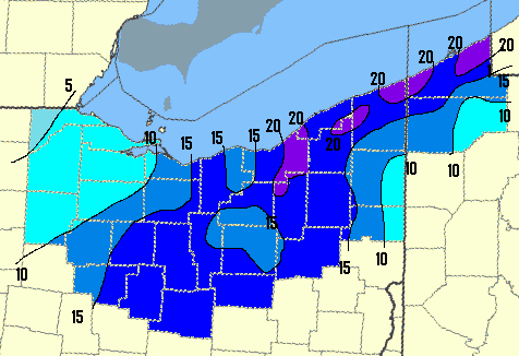
Snowfall amounts ranged from as little as 5 inches west of Toledo to over 20 inches in parts of Cuyahoga, Geuaga, Ashtabula and Erie (PA) counties. In general, north-central and northeast Ohio received over 15 inches of snow with the highest amounts along the I-71 corridor eastward and along the lakeshore from Cleveland through Erie County PA into western New York. North winds of 20 to 30 mph with higher gusts created drifts of 3 feet or more. The snow began just before noon Friday. By Saturday morning the snow was already 6 to 12 inches deep. Moderate to heavy snow continued through Saturday afternoon with blizzard conditions at times, finally winding down from west to east during the evening hours. This snowstorm has put Youngstown over the edge with a record seasonal snowfall (as of Sunday, March 9) of 94.3 inches. This breaks the previous record of 90.2 inches set during the 2006-2007 season. Below is a list of snowfall tallies the NWS Cleveland office received from their dedicated volunteer snow observers. |
|
---OHIO---
|
|
|---|---|
| ASHTABULA COUNTY | |
| Pierpont 2SE | 25.5 |
| Dorsett 3W | 23.5 |
| Conneaut at I-90 | 23.0 |
| Ashtabula 1SW | 19.4 |
| Saybrook | 19.0 |
| Windsor | 14.0 |
|
|
|
| CRAWFORD COUNTY | |
| Galion | 21.0 |
| Bucyrus | 20.5 |
| New Washington 5S | 18.9 |
| Galion | 13.5 |
|
|
|
| CUYAHOGA COUNTY | |
| Broadview Hts | 21.5 |
| Solon | 21.4 |
| Euclid | 21.0 |
| Garfield Hts | 17.0 |
| Shaker Hts | 17.0 |
| Lakewood | 16.3 |
| Pepper Pike | 15.7 |
| Cleveland Airport | 14.8 |
| Cleveland | 13.0 |
|
|
|
| ERIE COUNTY | |
| Vermilion | 18.1 |
| Sandusky | 12.0 |
|
|
|
| GEAUGA COUNTY | |
| Russel Twp. | 23.0 |
| Thompson 3S | 23.0 |
| Hamden Twp | 21.6 |
| Thompson 5SW | 21.1 |
| Claridon Twp | 19.1 |
| Chardon | 18.0 |
| Montville | 17.7 |
| Burton | 17.0 |
| Chardon | 17.0 |
| Middlefield 3SE | 15.3 |
| HURON COUNTY | |
| New London 3NW | 17.3 |
| Norwalk | 14.0 |
| Norwalk | 12.0 |
| LAKE COUNTY | |
| Madison 5S | 28.5 |
| Painseville Twp. | 19.0 |
| Mentor | 18.5 |
| Madison | 18.0 |
| Concord Twp. | 17.3 |
| Mentor 1S LK | 17.0 |
| Concord Twp. | 16.0 |
| Painseville | 15.9 |
| Willoughby | 15.1 |
| Kirtland | 14.5 |
| Mentor | 14.3 |
| Perry Twp | 13.0 |
| LORAIN COUNTY | |
| Wellington | 16.0 |
| Lagrange | 14.0 |
| N. Ridgeville | 13.5 |
| Oberlin | 13.5 |
| Elyria 3E | 11.5 |
| LUCAS COUNTY | |
| Toledo - Pt Place | 7.2 |
| Maumee | 5.5 |
| Toledo Airport | 5.2 |
| MAHONING COUNTY | |
| Austintown | 8.1 |
| MARION COUNTY | |
| Marion | 15.4 |
| Prospect | 13.0 |
| MEDINA COUNTY | |
| Medina | 16.0 |
| Hinckley | 14.8 |
| Brunswick | 13.2 |
| Chippewa Lake | 12.0 |
| PORTAGE COUNTY | |
| Ravenna 1E | 18.6 |
| Hiram | 17.5 |
| Mantua | 12.5 |
| RICHLAND COUNTY | |
| Mansfield Airport | 19.7 |
| Mansfield | 18.0 |
| SANDUSKY COUNTY | |
| Oak Harbor 5S | 5.3 |
| STARK COUNTY | |
| Massillon | 19.0 |
| SUMMIT COUNTY | |
| Richfield | 24.2 |
| Twinsburg | 19.0 |
| Akron-Canton Airport (CAK) | 17.1 |
| Tallmadge | 13.9 |
| Tallmadge 2NE | 13.8 |
| Green | 12.5 |
| TRUMBULL COUNTY | |
| Newton Falls | 16.0 |
| Youngstown-Warren Airport (YNG) | 11.6 |
| Warren | 10.0 |
| Champion | 9.0 |
| WAYNE COUNTY | |
| Wooster | 15.9 |
| Kidron 1N | 14.5 |
| Wooster | 14.5 |
| Dalton | 13.5 |
| Wooster 7N | 13.5 |
|
---PENNSYLVANIA---
|
|
| ERIE COUNTY | |
| Franklin Center | 24.8 |
| Erie Airport (ERI) | 23.4 |
| Northeast | 23.0 |
| Waterford | 22.9 |
| Millcreek Twp. | 19.5 |
| Lake City | 18.3 |
| Amity Twp. | 12.4 |
| Edinboro | 10.0 |
| CRAWFORD COUNTY | |
| Springboro 3NW | 16.5 |
| Meadville 5W | 15.0 |
| Linesville | 13.3 |
| Meadville | 11.2 |
| Titusville | 8.0 |
|
|
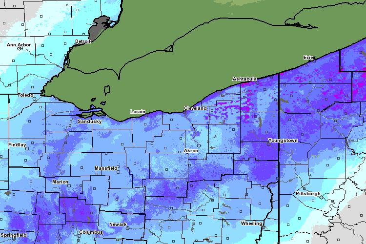
| The above image is from NOAA's National Operational Hydrologic Remote Sensing Center. This is from their National Snow Analysis and is based on modeled snow pack characteristics that are updated each day using all operationally available ground, airborne, and satellite observations of snow water equivalent, snow depth, and snow cover. This particular image is of the snow cover across northern Ohio and northwest Pennsylvania from the morning of March 9 (Sunday). |