May 7-8, 2010Severe Storms and Strong Winds Buffet Northern OH/ Northwest PA |
|---|
Tornado Confirmed in Wood County
|
The National Weather Service conducted a damage survey south of New Rochester in Wood county on May 10th and determined that a tornado occurred during the evening hours of May 7, 2010. An EF1 tornado touched down in rural Wood county near the intersection of Portage and Emerson roads in Montgomery Township. The tornado traveled north-northeast approximately 2 miles before lifting near the intersection of Kenner Road and U.S. Route 6 near New Rochester. Five barns were leveled along the damage path. Several homes also sustained roof damage. Two grain bins were also destroyed. Many trees and limbs were downed along the damage path. A rating of EF1 on the Enhanced Fujita Scale corresponds to estimated winds between 90 and 100 MPH. |
||||||||||||||||||||
|
|||||||||||||||||||||
Downburst Straight Line Wind Damage
in Erie County, Ohio
|
After a National Weather Service survey, damage in western Erie county was determined to be that of downburst straight line winds. The damage began southwest of Sandusky along Homegardner Road where a barn was damaged and many trees toppled. The damage path continued northeast across State Route 2 and 101 and through the city of Sandusky. The most concentrated damage was along State Route 101 between State Route 2 and the Sandusky city limits. Many trees and tree limbs were downed in this area along with 13 utility poles. A few homes and buildings sustained roof damage in this area as well. Damage in the city of Sandusky was sporadic and consisted of mainly downed trees and limbs. |
Thunderstorms Produce Hail and Wind
and One Tornado
|
|
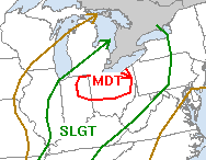
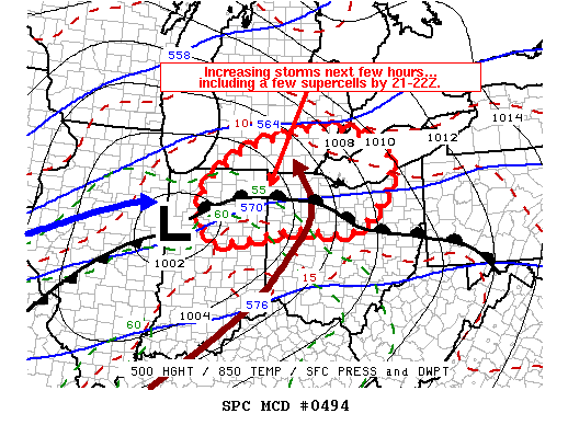
The day began with an outlook for a moderate risk of severe storms from the Storm Prediction Center (SPC). The concern was with a deepening area of low pressure that was going to track toward northwest Ohio. A warm front was situated across northern Ohio and was expected to provide a focus for storms. There was a threat for a few tornadoes along with storms that would produce hail and damaging winds. | |||
|
||||
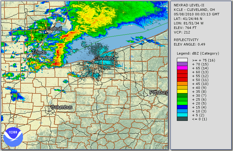
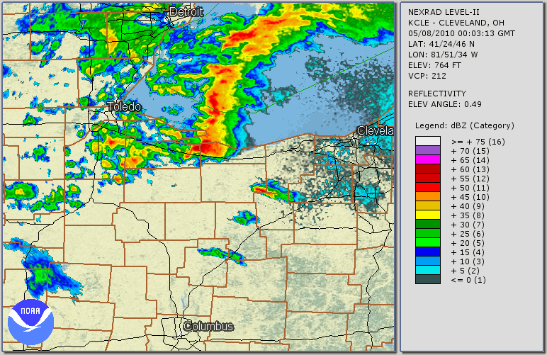
| The radar animation below shows the evolution of the line of thunderstorms out ahead of the cold front. This loop runs from 8 pm through 1 am. Click radar imagery below to enlarge. The first storms to initiate were discrete supercells in northwest Ohio. There was one storm that hugged the coast line from Sandusky to Cleveland and another that formed across northern Wood county and moved east to Huron. Later a few bowing segments developed as the line of thunderstorms filled in and moved eastward. | ||||
 |
||||
| Hardest hit areas included locations from southern Wood county across Erie county and finally into Cuyahoga county. Click radar imagery below to enlarge. Early in this zoomed in radar loop, a supercell can be found moving from just south of Sandusky to Huron and Vermilion. It has a classic "hook" shape to it. This storm moved into Lakewood and Cleveland producing more damage. While no tornado developed from this supercell, there were plenty of large hail and strong winds reported. | ||||
 |
||||
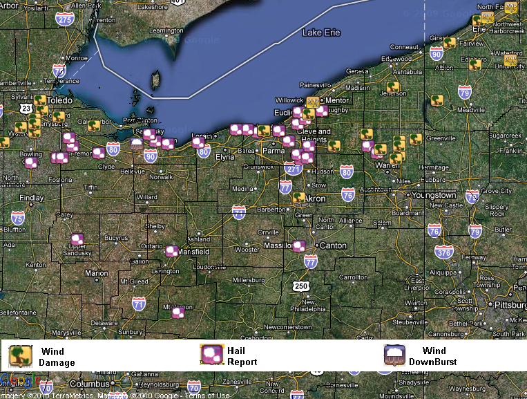
| The following is a map of all of the severe storm reports that we received at the National Weather Service. Click the map below to enlarge. | ||||
|
|
||||
| All of the preliminary local storm reports (LSRs) can be found in text format here. The storm report information is preliminary and subject to change pending final review and publication in NWS StormData. | ||||
|
||||
Strong Winds Follow the Cold Front
Winds gusted upwards of 50 MPH on Saturday following the front and temperatures dropped from highs around 80 on Friday to the 40s and low 50s with lake effect rain showers for Saturday. |
|||||||||||||||||||||||||||||||||||||||||||||||||||