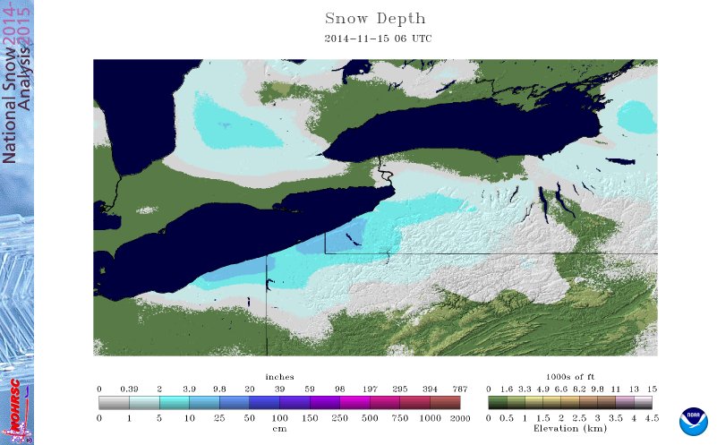
 The first significant snowfall of the 2014-2015 winter season arrived with a fury. Colder temperatures rushed into the region and the lake effect snow started during the day on Thursday, November 13, 2014. By noon, a southwest-northeast oriented band that was hugging the lakeshore shifted more west-east and deposited snow from Lake County up to Erie, PA. By just 2pm Mentor OH had reported 7 inches of snow and Millcreek Twp near Erie, PA reported 8 inches.
The lake-generated instability allowed for the development of thundersnow. Again, reports came in from Mentor of the rare, but not unheard of, phenomena.
Lake effect snow had no reason to quit and continued to bring snow to the snowbelt Thursday night and through the day Friday. As the winds shifted the west side of Cleveland also received several inches of snow.
ERIE, PA
On Nov. 13, 2014 Erie, PA had 12.6 inches of snow. This is the earliest occurrance of a snowfall of this magnitude.
| 11/13/2014: 12.6 inches | 11/23/70: 15.4 inches |
| 11/05/67: 12.5 inches | 11/24/50: 19.5 inches |
| 11/10/1913: 12.5 inches | 11/26/47: 12.1 inches |
| 11/21/64: 12.4 inches | 11/29/79: 17.4 inches |
| 11/21/2000: 14.5 inches | 11/29/76: 16.1 inches |
| 11/22/56: 20.0 inches |