Multiple Rounds of Storms Pack "One-Two Punch" to Lakeshore Counties
June 22-23, 2015
A low pressure system moved across the Great Lakes on the evening of Monday, June 22. A strong cold front trailed this low pressure system and produced an impressive line of thunderstorms, called a mesoscale convective system over Minnesota, Iowa, Wisconsin, and Illinois on the morning of the 22nd. The warm sector ahead of the cold front was very impressive with temperatures reaching the mid-80s and rather moderate instability in place for storms to develop in the afternoon. The low-level jet dynamics also looked favorable for severe weather to develop in both the afternoon and overnight hours.
Just after 4pm on June 22, thunderstorms developed along the I-75 corridor and moved along the lakeshore counties, prompting several severe thunderstorm warnings and one tornado warning. Storms general caused minimal damage and a funnel cloud was sighted just south of Sandusky.
In the early morning hours of June 23, a cluster of thunderstorms developed over Lake Erie. These storms moved ashore off of Lake Erie around 4am and impacted the immediate lakeshore counties around the Cleveland metro area. Damage was reported in Avon Lake and Madison. The ASOS at Burke Lakefront Airport also reported a wind gust of 52 mph. Shortly thereafter, a residual line of thunderstorms moved across Lake Erie onto the lakeshore. This line of storms had produced damage in Michigan, including several tornadoes. The area impacted from the first round of thunderstorms from Avon Point to Geneva was also impacted by this next round. Eastlake had the worst damage from these storms as over 30 large trees were knocked down with several trees landing on homes, businesses, and vehicles. The three rounds of thunderstorms caused flooding issues in Avon Lake and Bay Village, west of Cleveland. Many basements flooded in these towns and some roads were closed due to high water.
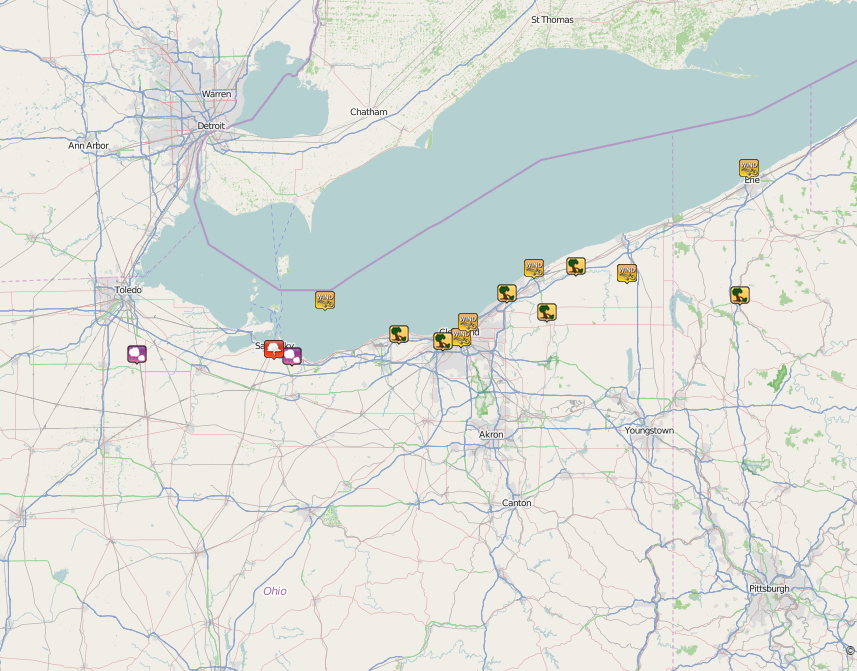
Local Storm Report Map Courtesy of the Iowa Environmental Mesonet (IEM) from Iowa State University.
Here are the Preliminary Storm Reports from June 22-23, 2015:
PRELIMINARY LOCAL STORM REPORT...SUMMARY
NATIONAL WEATHER SERVICE CLEVELAND OH
739 PM EDT MON JUN 22 2015

...TIME...  ...EVENT...      ...CITY LOCATION...     ...LAT.LON...
...DATE...  ....MAG....      ..COUNTY LOCATION..ST.. ...SOURCE....
            ..REMARKS..

0430 PM     HAIL             PEMBERVILLE             41.41N 83.46W
06/22/2015  M1.00 INCH       WOOD               OH   EMERGENCY MNGR

0505 PM     HAIL             3 W HURON               41.40N 82.61W
06/22/2015  E1.00 INCH       ERIE               OH   PUBLIC

0525 PM     FUNNEL CLOUD     2 S SANDUSKY            41.43N 82.71W
06/22/2015                   ERIE               OH   LAW ENFORCEMENT

            FUNNEL CLOUD SIGHTED NEAR PERKINS AVENUE IN
            SANDUSKY

0558 PM     TSTM WND DMG     CHARDON                 41.58N 81.21W
06/22/2015                   GEAUGA             OH   LAW ENFORCEMENT

            GEAUGA COUNTY DISPATCH REPORTED SEVERAL
            TREES DOWN IN THE COUNTY. TREES WERE DOWN ON
            ROUTE 6 AND CHARDON-WINDSOR ROAD.


PRELIMINARY LOCAL STORM REPORT...SUMMARY
NATIONAL WEATHER SERVICE CLEVELAND OH
231 PM EDT TUE JUN 23 2015

..TIME...   ...EVENT...      ...CITY LOCATION...     ...LAT.LON...
..DATE...   ....MAG....      ..COUNTY LOCATION..ST.. ...SOURCE....
            ..REMARKS..

0340 AM     MARINE TSTM WIND 18 NW LORAIN            41.63N 82.43W
06/23/2015  M49.00 MPH       LEZ164             OH   BUOY

            BUOY 45005

0354 AM     MARINE TSTM WIND 3 NNW PAINESVILLE       41.76N 81.28W
06/23/2015  M55.00 MPH       LAKE               OH   OTHER FEDERAL

            FAI01

0400 AM     TSTM WND DMG     MADISON                 41.77N 81.05W
06/23/2015                   LAKE               OH   911 CALL CENTER

            NUMEROUS TREES AND POWER LINES DOWN.

0410 AM     TSTM WND DMG     AVON LAKE               41.49N 82.02W
06/23/2015                   LORAIN             OH   TRAINED SPOTTER

            TRAINED SPOTTERS AND AMATEUR RADIO REPORTED TREES DOWN IN
            AVON LAKE NEAR LAKE ROAD AND REDWOOD AVENUE. ROOF OF
            BUILDING AT POWER PLANT WAS ALSO DAMAGED.

0415 AM     TSTM WND GST     CLEVELAND               41.48N 81.68W
06/23/2015  M52.00 MPH       CUYAHOGA           OH   ASOS

            BURKE LAKEFRONT AIRPORT

0418 AM     MARINE TSTM WIND 5 NNE CLEVELAND         41.54N 81.64W
06/23/2015  M56.00 MPH       CUYAHOGA           OH   BUOY

            CND01

0426 AM     TSTM WND GST     JEFFERSON               41.74N 80.77W
06/23/2015  M46.00 MPH       ASHTABULA          OH   ASOS

            NORTHEAST OHIO REGIONAL AIRPORT

0454 AM     MARINE TSTM WIND 3 N ERIE                42.17N 80.10W
06/23/2015  M43.00 MPH       ERIE               PA   BUOY

0455 AM     TSTM WND DMG     MEADVILLE               41.65N 80.15W
06/23/2015                   CRAWFORD           PA   911 CALL CENTER

            CRAWFORD COUNTY DISPATCH REPORTED A FEW TREES DOWN IN THE
            COUNTY...MOST TREES WERE IN THE MEADVILLE AREA.

0542 AM     TSTM WND DMG     EASTLAKE                41.66N 81.43W
06/23/2015                   LAKE               OH   FIRE DEPT/RESCUE

            EASTLAKE FIRE DEPT REPORTED 32 TREES DOWN ACROSS THE CITY
            OF EASTLAKE. SEVERAL OF THESE TREES CAUSED DAMAGE TO
            HOMES AND VEHICLES. MOST TREES WERE SNAPPED ABOVE THE
            BASE. POWER LINES WERE ALSO DOWN IN AREA.

0545 AM     TSTM WND DMG     5 WSW CLEVELAND         41.46N 81.78W
06/23/2015                   CUYAHOGA           OH   BROADCAST MEDIA

            BROADCAST MEDIA POSTED A PHOTO ON SOCIAL MEDIA OF A LARGE
            TREE THAT FELL ON A HOUSE IN THE WEST SIDE OF
            CLEVELAND...TIME IS RADAR ESTIMATED.


&&

$$

SEFCOVIC

