Event Summary:
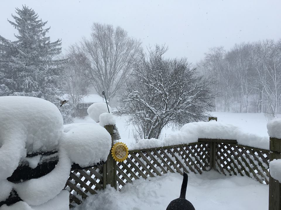
An arctic cold front moved east across the Great Lakes Region on Sunday January 17th, ushering in the coldest air of the season. Most of northern Ohio received a light coating of snow as this system moved through, with snowfall totals ranging from a trace in Toledo to several inches of snow across the snowbelt region of northeast Ohio and northwest Pennsylvania. Heavy lake effect snow then developed on Sunday night and continued at times through Tuesday as a prolonged period of west to northwest flow set up across Lake Erie. Lake Erie is experiencing below normal ice coverage this winter due to warm temperatures in December and early January. The lake was mostly ice free east of the islands which supplied the necessary moisture to maintain a prolonged period of lake effect snow. Westerly winds of 10 to 20 mph with gusts to 30 mph accompanied the snow. Areas outside of the snowbelt may have escaped the snow but did not escape the cold as wind chill values dropped to between zero and -17 on Sunday night.
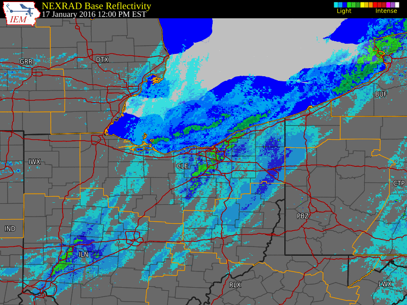
The radar loop below shows hourly radar images from noon on Sunday January 17th to 3 pm on Tuesday January 19th. Snow fluctuated in intensity through the duration of the event, with heavy bands developing at times. These heavier bands noted by the green color on the radar image were typically less than 10 miles wide but shifted up and down the lakeshore. Lake effect snow bands can be particularly hazardous to motorists due to the rapid variation in intensity encountered over short distances. The highest snowfall totals in Ohio were recorded in Geauga County with the highest totals in Pennsylvania recorded in Erie County. A summary of snowfall reports can be found below.
Our thanks are extended to everyone that sent in snowfall reports to the National Weather Service throughout the duration of the event.
Radar Loop of the event from 12pm on January 17, 2016 to 3pm on January 19, 2016:
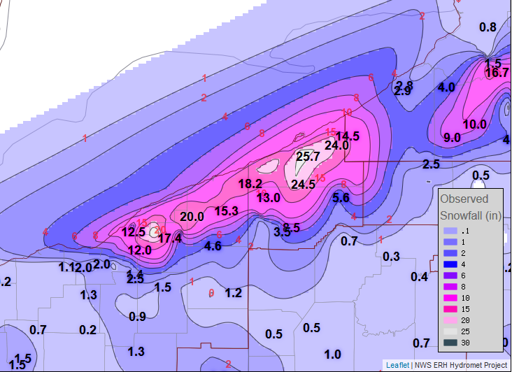
Storm Total Snowfall Map
Surface pressure analysis with observations from 1 pm on January 18, 2016:

Below are unofficial storm total snowfall amounts from across Northeast Ohio and NW PA:
PUBLIC INFORMATION STATEMENT
NATIONAL WEATHER SERVICE CLEVELAND OH
615 PM EST WED JAN 20 2016

...STORM TOTAL SNOWFALL AMOUNTS ACROSS NORTHEAST OHIO AND
NORTHWEST PENNSYLVANIA FROM SUNDAY MORNING THROUGH TUESDAY EVENING...

THE FOLLOWING ARE UNOFFICIAL STORM TOTAL SNOW OBSERVATIONS TAKEN
DURING THE SNOW THAT HAS BEEN IMPACTING NORTHEAST OHIO AND NORTHWEST
PENNSYLVANIA. THIS REPORT SHOWS STORM TOTAL SNOW VALUES FROM 7 AM
SUNDAY JANUARY 17 TO 9 PM TUESDAY JANUARY 19. APPRECIATION IS
EXTENDED TO HIGHWAY DEPARTMENTS...COOPERATIVE OBSERVERS...SKYWARN
SPOTTERS AND MEDIA FOR THESE REPORTS. THIS SUMMARY IS ALSO AVAILABLE
ON OUR HOME PAGE AT WEATHER.GOV/CLEVELAND
********************STORM TOTAL SNOWFALL********************

STORM TOTAL SNOW FROM 700 AM SUN JAN 17 TO 900 PM TUE JAN 19 2016.

LOCATION          STORM TOTAL     TIME/DATE   COMMENTS
                     SNOWFALL           OF
                     /INCHES/   MEASUREMENT

OHIO

...ASHTABULA COUNTY...
   CONNEAUT I-90         18.2   900 PM  1/19  STORM TOTAL SNOW
   PIERPONT 2SE          16.0   900 PM  1/19  STORM TOTAL SNOW
   JEFFERSON             15.3   900 PM  1/19  STORM TOTAL SNOW
   ASHTABULA             13.3   900 PM  1/19  STORM TOTAL SNOW
   ORWELL 1E              4.6   900 PM  1/19  STORM TOTAL SNOW

...CUYAHOGA COUNTY...
   EUCLID                12.5   900 PM  1/19  STORM TOTAL SNOW
   MAYFIELD HEIGHTS      12.0   900 PM  1/19  STORM TOTAL SNOW
   SHAKER HTS             7.0   900 PM  1/19  STORM TOTAL SNOW
   SOLON                  3.3   900 PM  1/19  STORM TOTAL SNOW
   2 E PARMA              2.0   900 PM  1/19  STORM TOTAL SNOW
   CLEVELAND-OLD BROOKL   2.0   900 PM  1/19  STORM TOTAL SNOW
   CLEVELAND HOPKINS AI   2.0   900 PM  1/19  STORM TOTAL SNOW

...GEAUGA COUNTY...
   CHARDON 2N            29.0   900 PM  1/19  STORM TOTAL SNOW
   SOUTH MADSION         20.0   900 PM  1/19  STORM TOTAL SNOW
   CHESTERLAND           18.0   900 PM  1/19  STORM TOTAL SNOW
   MONTVILLE             17.5   900 PM  1/19  STORM TOTAL SNOW
   CHARDON               17.4   900 PM  1/19  STORM TOTAL SNOW
   CLARIDON TWP          17.0   900 PM  1/19  STORM TOTAL SNOW
   BURTON                11.0   900 PM  1/19  STORM TOTAL SNOW

...LAKE COUNTY...
   KIRTLAND 4SW          21.8   900 PM  1/19  STORM TOTAL SNOW
   3 SW WILLOUGHBY       14.2   700 AM  1/20  STORM TOTAL SNOW
   LAKE CTY/PAINESVILLE  12.0   900 PM  1/19  STORM TOTAL SNOW
   MENTOR                10.0   900 PM  1/19  STORM TOTAL SNOW
   MADISON-ON-THE-LAKE    6.8   900 PM  1/19  STORM TOTAL SNOW

...LORAIN COUNTY...
   N RIDGEVILLE           1.1   900 PM  1/19  STORM TOTAL SNOW

...MEDINA COUNTY...
   HINCKLEY               1.6   900 PM  1/19  STORM TOTAL SNOW
   BRUNSWICK              1.3   900 PM  1/19  STORM TOTAL SNOW

...PORTAGE COUNTY...
   HIRAM                  1.8   900 PM  1/19  STORM TOTAL SNOW
   2 SSW STREETSBORO      1.4   700 AM  1/20  STORM TOTAL SNOW

...SUMMIT COUNTY...
   TWINSBURG              2.5   900 PM  1/19  STORM TOTAL SNOW
   AKRON CANTON AIRPORT   1.3   900 PM  1/19  STORM TOTAL SNOW
   AKRON W SIDE           1.3   900 PM  1/19  STORM TOTAL SNOW

...TRUMBULL COUNTY...
   YOUNGSTOWN WARREN AI   1.2   900 PM  1/19  STORM TOTAL SNOW

PENNSYLVANIA

...CRAWFORD COUNTY...
   SPRINGBORO 3NW        13.0   900 PM  1/19  STORM TOTAL SNOW
   CONNEAUTVILLE 6SW     12.7   900 PM  1/19  STORM TOTAL SNOW
   MEADVILLE 5W           8.5   900 PM  1/19  STORM TOTAL SNOW
   1 NE CONNEAUT LAKE     5.9   700 AM  1/20  STORM TOTAL SNOW
   CANADOHTA LAKE         5.6   900 PM  1/19  STORM TOTAL SNOW

...ERIE COUNTY...
   MILLCREEK TWP         25.7   900 PM  1/19  STORM TOTAL SNOW
   2 NW EDINBORO         24.5   900 PM  1/19  STORM TOTAL SNOW
   NORTHEAST 6SW         24.0   900 PM  1/19  STORM TOTAL SNOW
   2 SW LAKE CITY        21.0   900 PM  1/19  STORM TOTAL SNOW
   FAIRVIEW              19.3   900 PM  1/19  STORM TOTAL SNOW
   CRANESVILLE           17.5   900 PM  1/19  STORM TOTAL SNOW
   COLT STATION          14.5   900 PM  1/19  STORM TOTAL SNOW
   ERIE AIRPORT          13.7   900 PM  1/19  STORM TOTAL SNOW
   CORRY                 12.0   900 PM  1/19  STORM TOTAL SNOW

