Location...6.5 miles NE of Clyde in Sandusky County, Ohio
Date...November 5, 2017
Start Time...2:18 PM EST
End Time...2:20 PM EST
Maximum EF-Scale Rating...EF1
Estimated Maximum Wind Speed...90-100 MPH
Maximum Path Width...50 yards
Path Length...1.34 miles
Fatalities...0
Injuries...0
* The information in this statement is preliminary and subject to
change pending final review of the event(s) and publication in
NWS Storm Data.
...Summary...
The National Weather Service in Cleveland OH has confirmed a
tornado 6.5 miles NE of Clyde in Sandusky County Ohio on
November 5 2017.
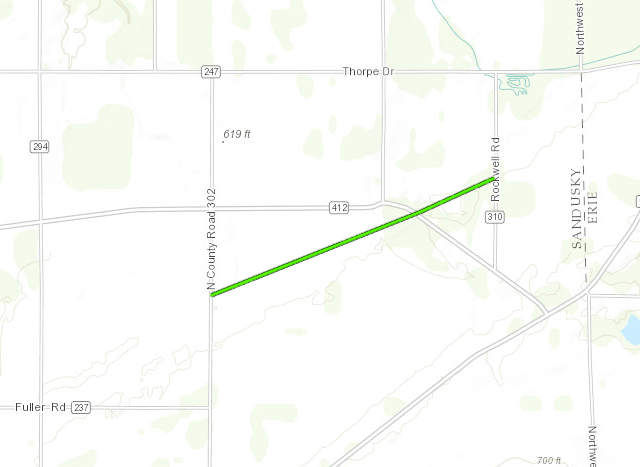
Tornado developed near Fuller Rd and North County Road 302. Along
its path it caused significant damage to the roof of 3 homes. The
tornado lifted near Thorpe and Rockwell roads.
This information can also be found on our website at
weather.gov/cle.
For reference: the Enhanced Fujita Scale classifies tornadoes
into the following categories:
EF0...Wind speeds 65 to 85 mph
EF1...Wind speeds 86 to 110 mph
EF2...Wind speeds 111 to 135 mph
EF3...Wind speeds 136 to 165 mph
EF4...Wind speeds 166 to 200 mph
EF5...Wind speeds greater than 200 mph
$$


 Follow us on YouTube