Overview
|
A cold front slowly sank across Lake Erie and northern Ohio early Monday morning into a moist environment characterized by precipitable water values up to 1.7-1.9 inches. A strong low level jet fueled persistence moisture advection along with significant back building and training of thunderstorms across the area between about 6am and 6pm Monday. This resulted in a widespread 2-5 inches of rain with isolated amounts even higher. The office was also notified of a potential Dam Break on Lower Shaker Lake near Coventry Road, which flows into Doan Brook. The staff was told Cuyahoga County would be issuing a CEM and we were going to follow up with a Flash Flood Warning after that went out. After about an hour, we were notified that the notification was not sent because water levels were starting to drop and concern for a release had decreased. Later that afternoon, the primary weather hazard shifted to severe with two tornado warnings and three severe thunderstorm warnings being issued, with lots of tree damage and hail up to 2 inches in diameter, mainly for Knox and Holmes Counties. The night concluded with significant flooding in the city of Marion after dark. |
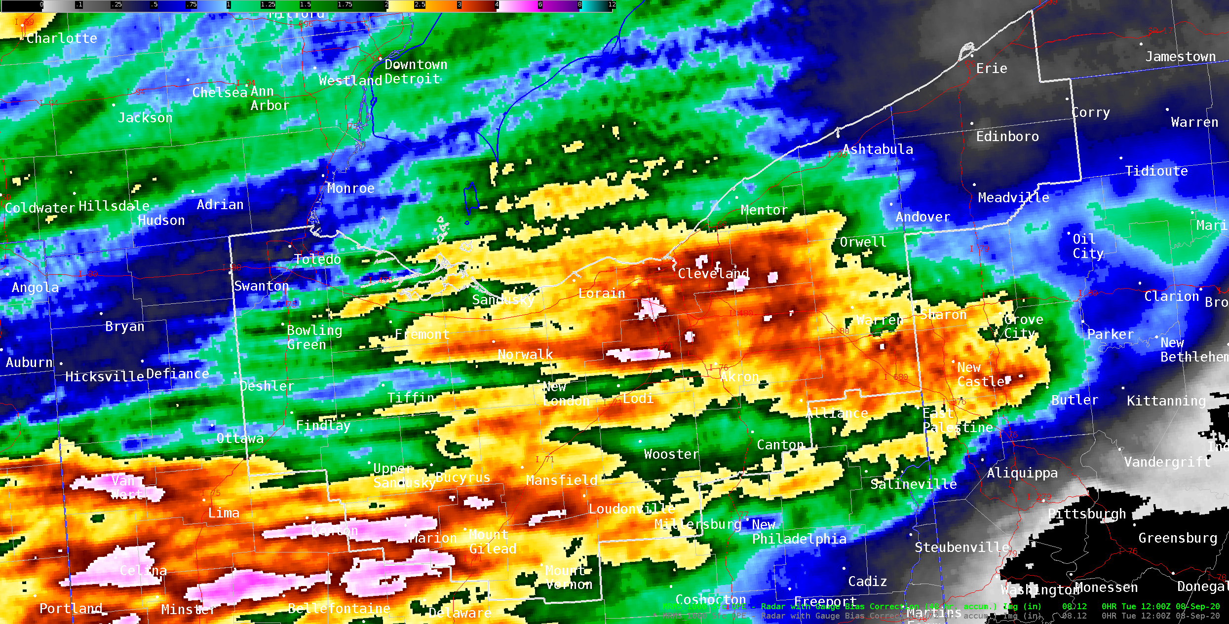 Radar estimated rainfall over a 48-hour period ending 8 AM Tuesday, September 8, 2020. Notice the 3 to 4-inch swath of rainfall that fell across northern Ohio and the Cleveland metro area. |
Photos & Video
 |
 |
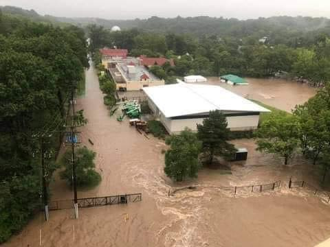
| Cleveland Metropark Zoo Flooding (Credit Michal Elaine Johnston) |
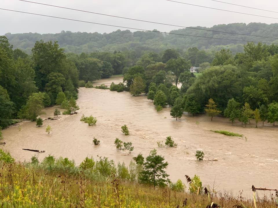
Bend at Tinkers Creek in Valley View (Credit Nicole Gillota-Briachacek) |
Storm Reports
 |
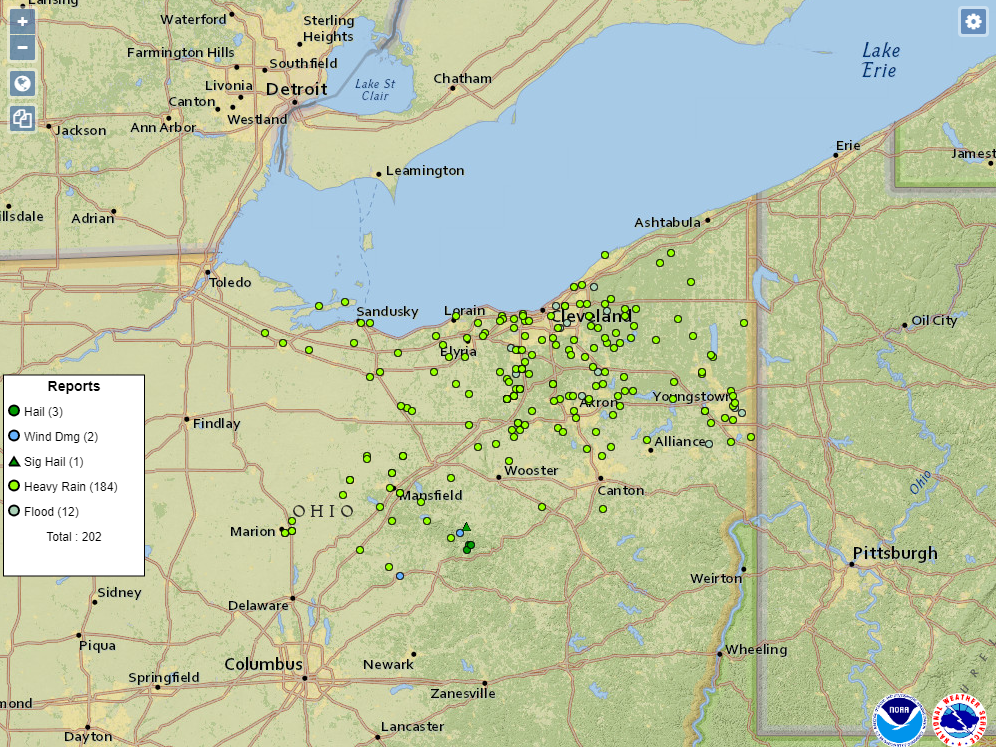 |
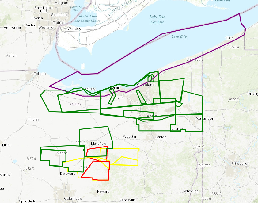
| Map of warning polygons over the course of the event. Red outlines indicate tornado warnings, yellow outlines indicate severe thunderstorm warnings, green outlines indicate flash flood warnings, and purple outlines indicate special marine warnings. | LSR map over the course of the event. Notice the abundance of "heavy rain" reports, indicated by the bright green dots. Also, notice the dark green and light blue dots in the southern portion of the area, indicating severe hail and wind reports later in the afternoon. |
.png) |
| PNS showing all of the precipitation reports over the course of the event. |
Local Storm Report Summary
000
NWUS51 KCLE 080403
LSRCLE

PRELIMINARY LOCAL STORM REPORT...SUMMARY
NATIONAL WEATHER SERVICE CLEVELAND OH
1203 AM EDT TUE SEP 8 2020

..TIME...   ...EVENT...      ...CITY LOCATION...     ...LAT.LON...
..DATE...   ....MAG....      ..COUNTY LOCATION..ST.. ...SOURCE....
            ..REMARKS..

0914 PM     FLOOD            CAMPBELL                41.07N 80.60W
09/07/2020                   MAHONING           OH   BROADCAST MEDIA

            CAMPBELL CITY HALL SUSTAINED WATER DAMAGE.

0500 PM     FLOOD            2 W STREETSBORO         41.24N 81.39W
09/07/2020                   PORTAGE            OH   PUBLIC

            EB/WB RT 303 CLOSED BETWEEN STONE RD AND
            JEFFERSON ST.

0500 PM     FLOOD            1 SW WAITE HILL         41.59N 81.41W
09/07/2020                   LAKE               OH   FIRE DEPT/RESCUE

            FIRE DEPARTMENT REPORTS FLOODING AT
            RESIDENCES ON MILAN DRIVE AS WELL AS A
            PORTION OF A NEARBY ROAD.

0457 PM     FLOOD            1 SW SILVER LAKE        41.14N 81.48W
09/07/2020                   SUMMIT             OH   PUBLIC

            ROUTE 8. NORTH CLOSED AT PERKINS (59).

0358 PM     FLOOD            2 SSW BEREA             41.34N 81.87W
09/07/2020                   CUYAHOGA           OH   LAW ENFORCEMENT

            PRIEM ROAD CLOSED NORTH OF ALBION ROAD AND
            MARKS ROAD CLOSED SOUTH OF JONATHAN DRIVE
            DUE TO FLOODING.

0335 PM     FLOOD            6 S CANFIELD            40.94N 80.78W
09/07/2020                   MAHONING           OH   DEPT OF HIGHWAYS

            SR 165 CLOSED BETWEEN US 62 AND SR 46 DUE TO
            HIGH WATER.

0155 PM     FLOOD            1 SSE YOUNGSTOWN        41.09N 80.64W
09/07/2020                   MAHONING           OH   PUBLIC

            THREE CARS STUCK IN FLOOD WATERS ON 725
            POLAND AVENUE.

1231 PM     FLOOD            2 S CHESTERLAND         41.49N 81.34W
09/07/2020                   GEAUGA             OH   BROADCAST MEDIA

            MANY LOCAL ROADS ARE FLOODED OR IMPASSABLE
            WITH 3.26 INCHES OF RAIN MEASURED SO FAR.

1100 AM     FLOOD            4 NE CLEVELAND          41.51N 81.62W
09/07/2020                   CUYAHOGA           OH   PUBLIC

            WATER RESCUE AT MARTIN LUTHER KING JR. DRIVE
            AND EAST SUPERIOR AVE. MULTIPLE VEHICLES
            STUCK IN THE WATER UNDER THE BRIDGE ON MLK.

1026 AM     FLOOD            GARFIELD HEIGHTS        41.42N 81.60W
09/07/2020                   CUYAHOGA           OH   DEPT OF HIGHWAYS

            TWO RIGHT LANES OF I-480 EAST AT
            SR-17/GRANGER RD BLOCKED DUE TO FLOODING.

0525 PM     HAIL             GLENMONT                40.52N 82.10W
09/07/2020  E1.00 INCH       HOLMES             OH   PUBLIC

            QUARTER SIZED HAIL. TIME ESTIMATED VIA
            RADAR.

0525 PM     HAIL             2 SSW GLENMONT          40.50N 82.11W
09/07/2020  E1.00 INCH       HOLMES             OH   PUBLIC


0521 PM     HAIL             GLENMONT                40.52N 82.09W
09/07/2020  M1.75 INCH       HOLMES             OH   TRAINED SPOTTER


0514 PM     HAIL             NASHVILLE               40.60N 82.11W
09/07/2020  E2.00 INCH       HOLMES             OH   PUBLIC


0552 PM     TSTM WND DMG     MOUNT VERNON            40.39N 82.48W
09/07/2020                   KNOX               OH   EMERGENCY MNGR

            NUMEROUS TREES DOWN ACROSS MOUNT VERNON.

0504 PM     TSTM WND DMG     3 SW NASHVILLE          40.57N 82.15W
09/07/2020                   HOLMES             OH   DEPT OF HIGHWAYS

            NUMEROUS TREES DOWN IN KNOX TOWNSHIP. ONE
            CREW HAS CUT UP AT LEAST 40 TREES.


&&

$$
|
|
||
| US Dept of Commerce National Oceanic and Atmospheric Administration National Weather Service 1325 East West Highway Silver Spring, MD 20910 Page Author: NWSChat Administration Team |
Disclaimer Information Quality Credits Glossary |
Privacy Policy Freedom of Information Act (FOIA) About Us Career Opportunities |
 |
Media use of NWS Web News Stories is encouraged! Please acknowledge the NWS as the source of any news information accessed from this site. |
|

