Overview
Multiple rounds of strong to severe thunderstorms moved across northern Ohio and northwest Pennsylvania during the afternoon and evening on May 21, 2022. A fast-moving convective complex passed across southern Ontario Province during the morning hours, sending an outflow boundary southward across Lake Erie. This boundary acted as a focus for thunderstorm development in the afternoon from Cleveland east to Erie, Pennsylvania. Meanwhile, a pre-frontal trough initiated thunderstorms over north central Ohio during the early afternoon.
These storms, along with the storms farther northeast up the lakeshore, merged into a broken line of strong to severe thunderstorms that swept east during the late afternoon and early evening hours producing large hail, localized wind damage, and locally heavy rainfall. Hail as large as hen egg-size (2" in diameter) fell in central Geauga County with other reports of golf ball-size hail in the county. As this line was moving east, a second line of severe thunderstorms organized across northwest and north-central Ohio along an approaching cold front and swept across the entire region. This second line produced pockets of damaging winds, large hail, and very heavy rainfall. Reports of greater than 1 inch of rain in under 30 minutes were common as this line moved through. Wind damage also occurred in parts of northwestern and north-central Ohio initially, before resuming in extreme northeast Ohio and into parts of northwestern Pennsylvania.
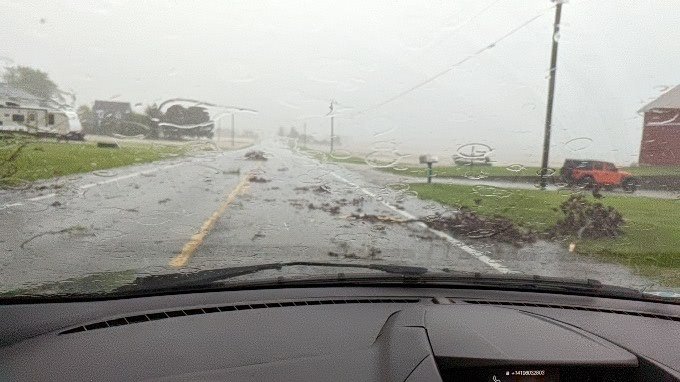
The multiple rounds of thunderstorms led to pockets of flooding from north-central Ohio through the lakeshore counties of northeast Ohio and northwest Pennsylvania. Southeastern Erie County in Pennsylvania was especially hard hit. Rainfall amounts of 3 to 5 inches led to major flash flooding in and around Union City, PA. Four homes were evacuated, displacing 20 people in shelters, and Academy Drive between the Union City junior and senior high schools was washed out. Several businesses were also evacuated on North and South Main Street. Water was reported to have reached the rooftops of the evacuated homes.
Photos & Video
 |
 |
 |
 |
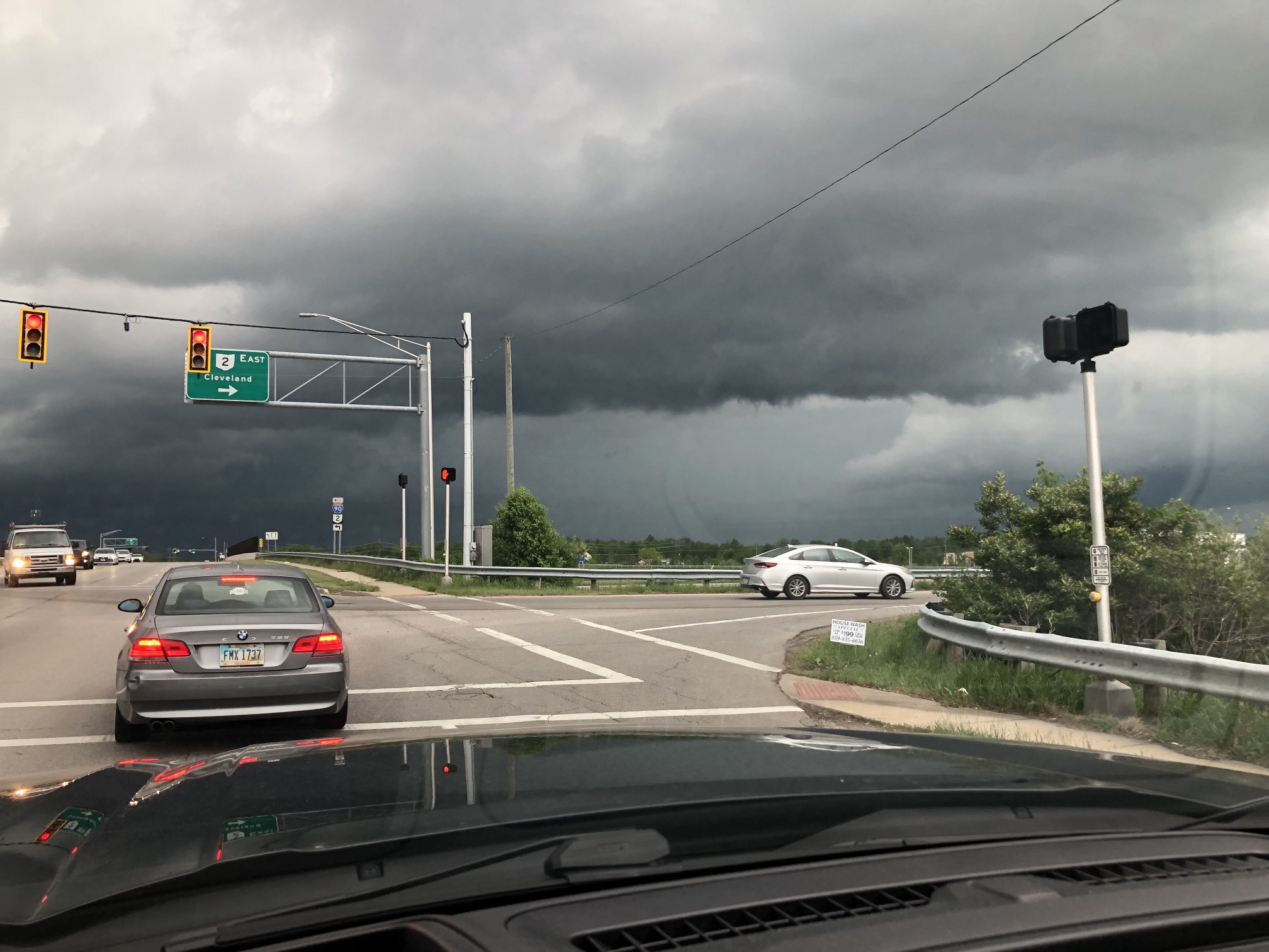
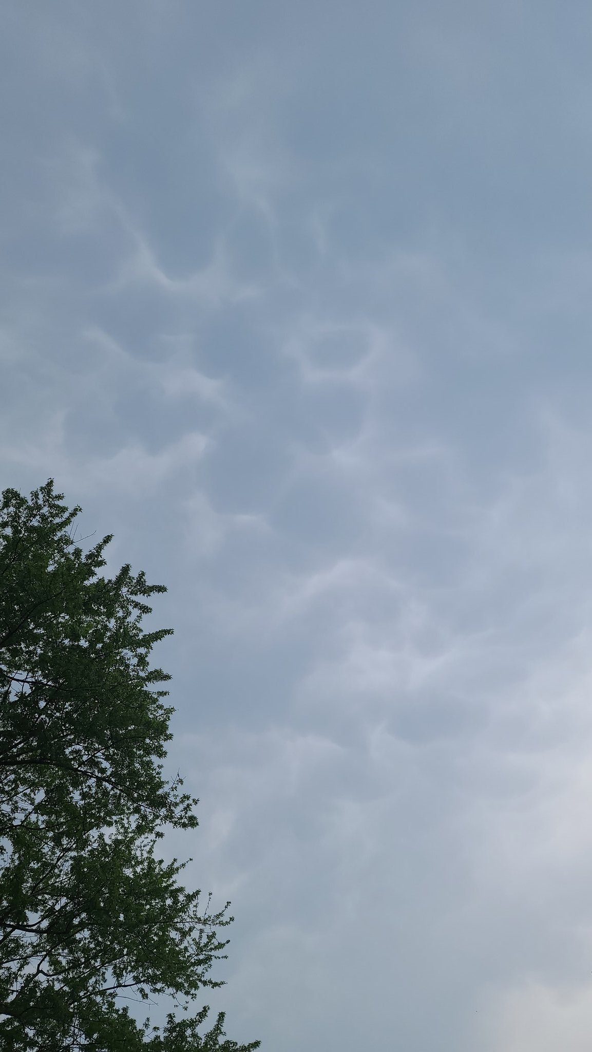
| Shelf Cloud in Avon (Thomas Kvach, Jr.) |
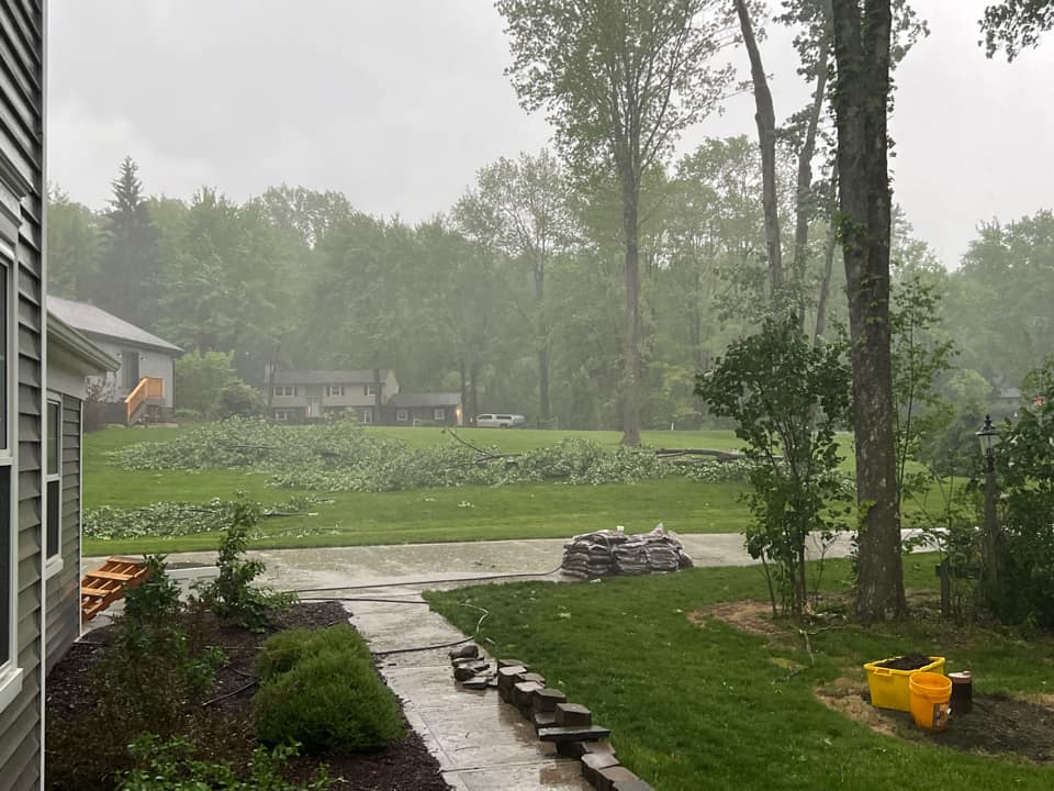
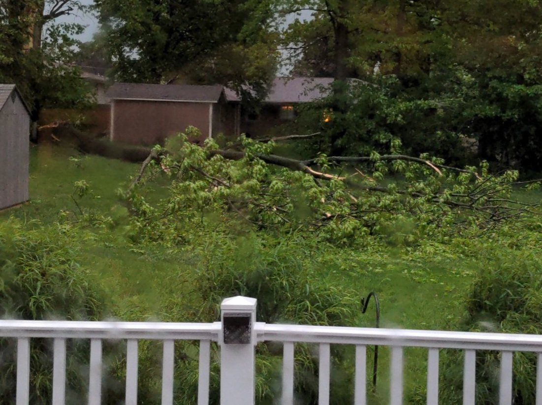
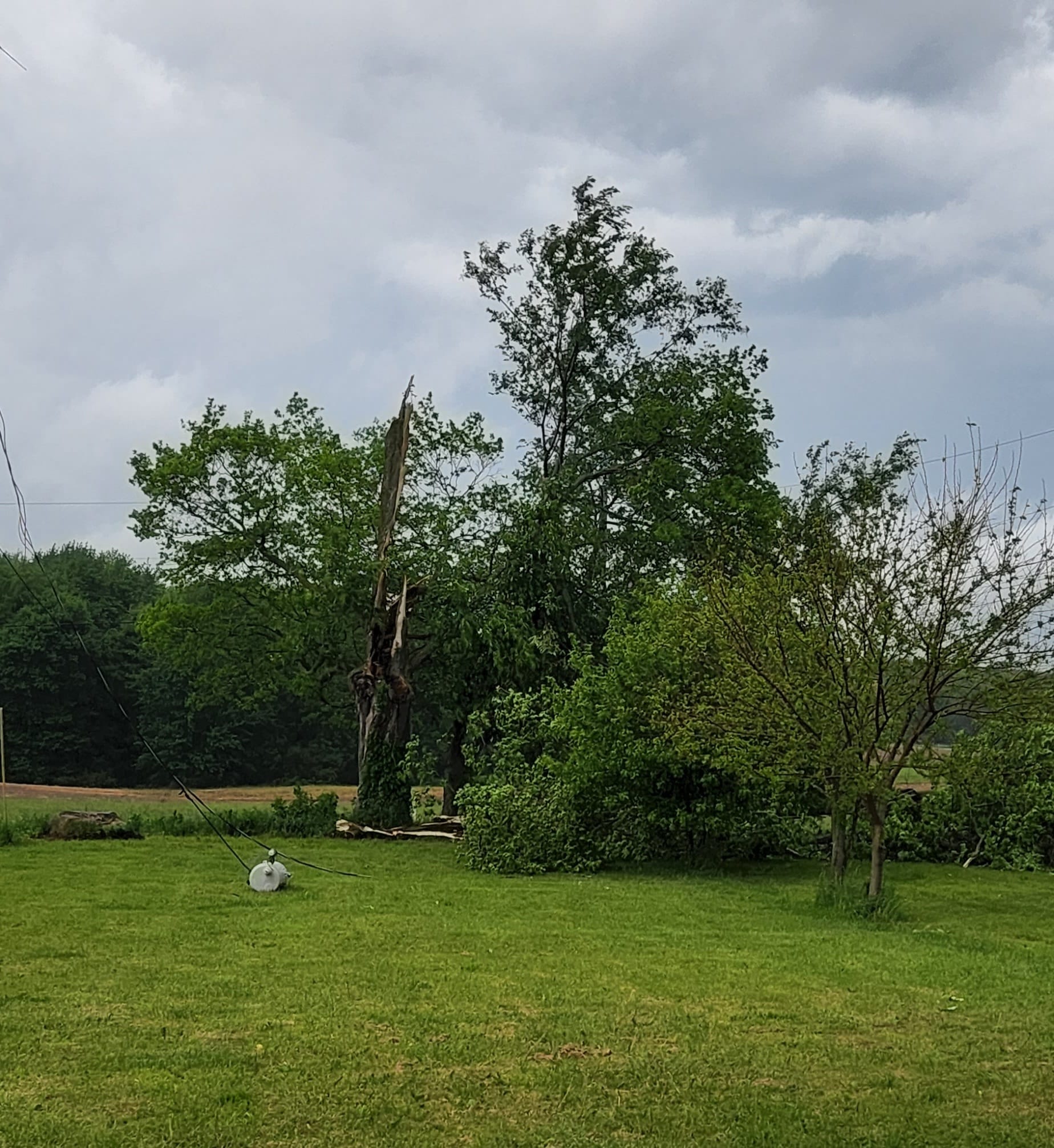
Tree Damage in Bainbridge/Aurora (Sarah Frank) |
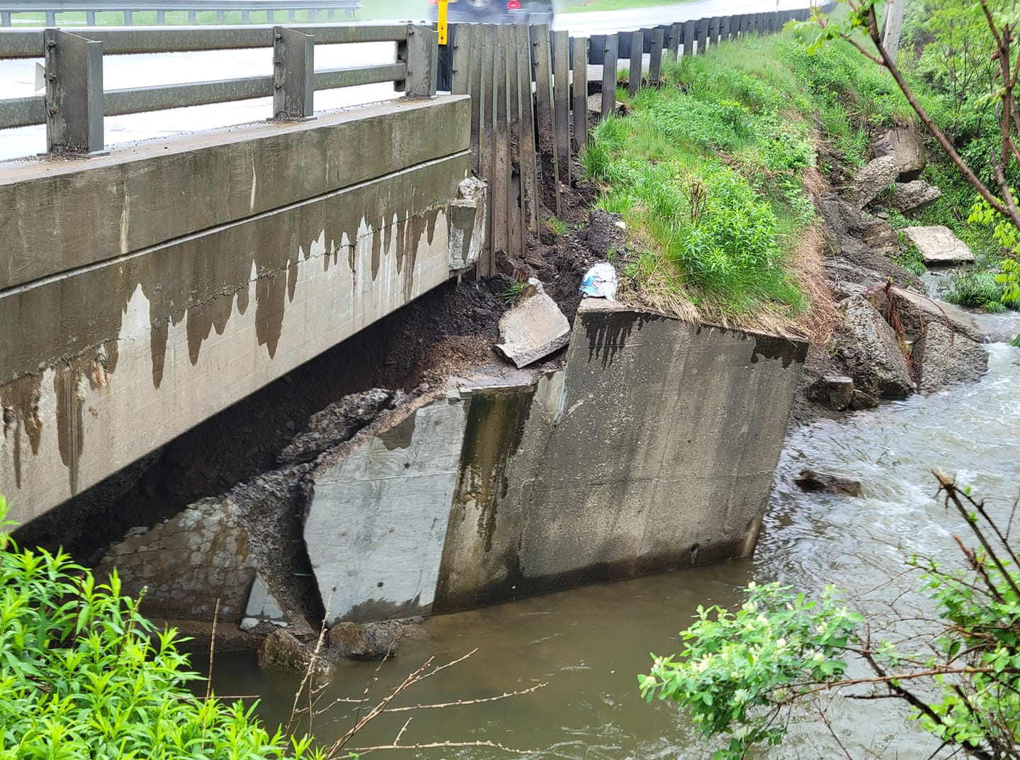
Bridge Damage Near Corry, PA (Sharon Warner) |
4 Trees Down in Burton (Sandi Battaglia) |
 |
 |
 |
 |
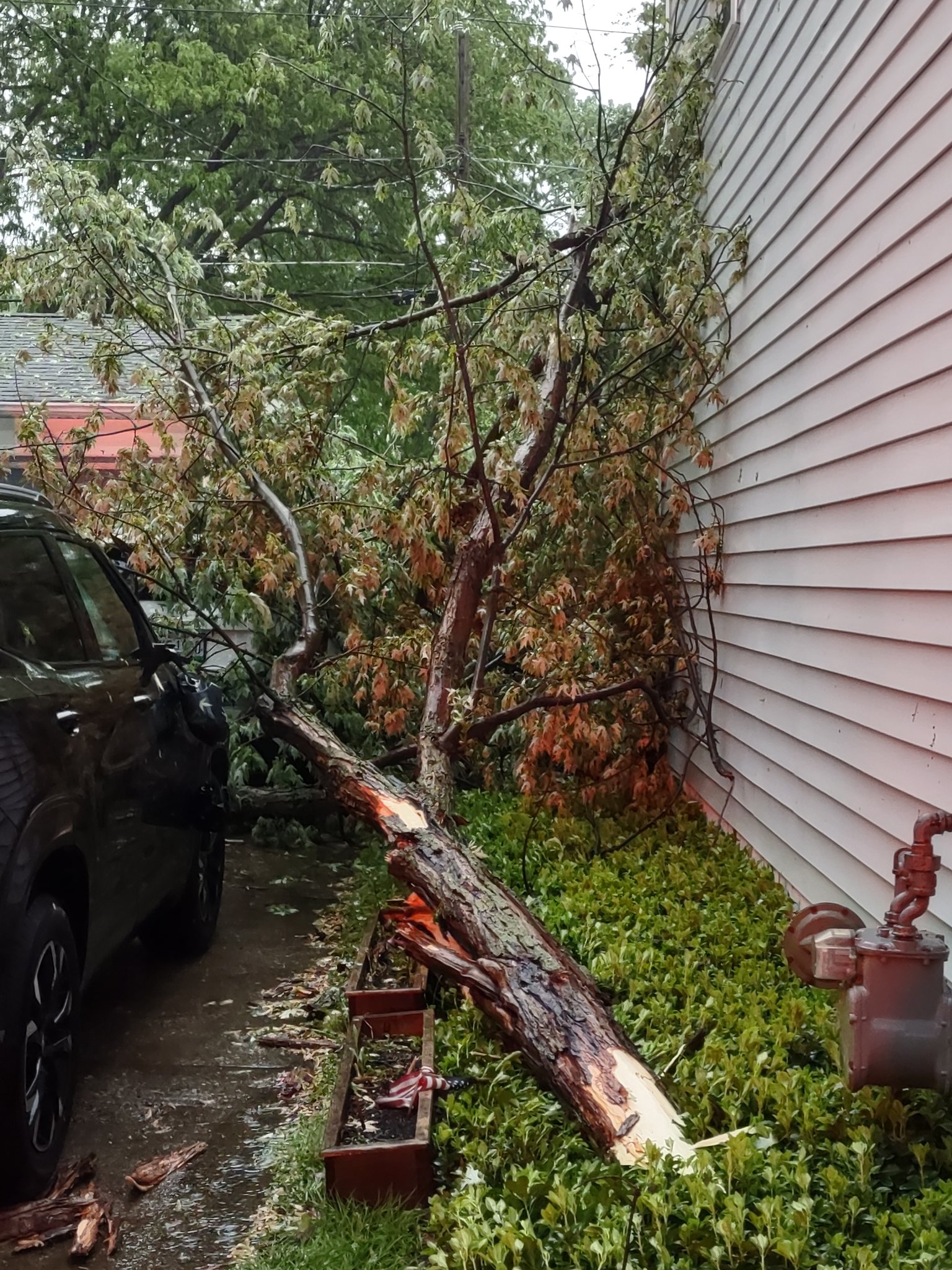
| Tree on House in Canton (Jenny) |
Tree on House in Canton (Jenny) |
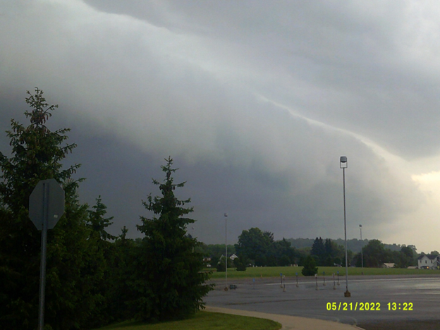
Shelf Cloud in Cochranton, PA (Todd Shiffer) |
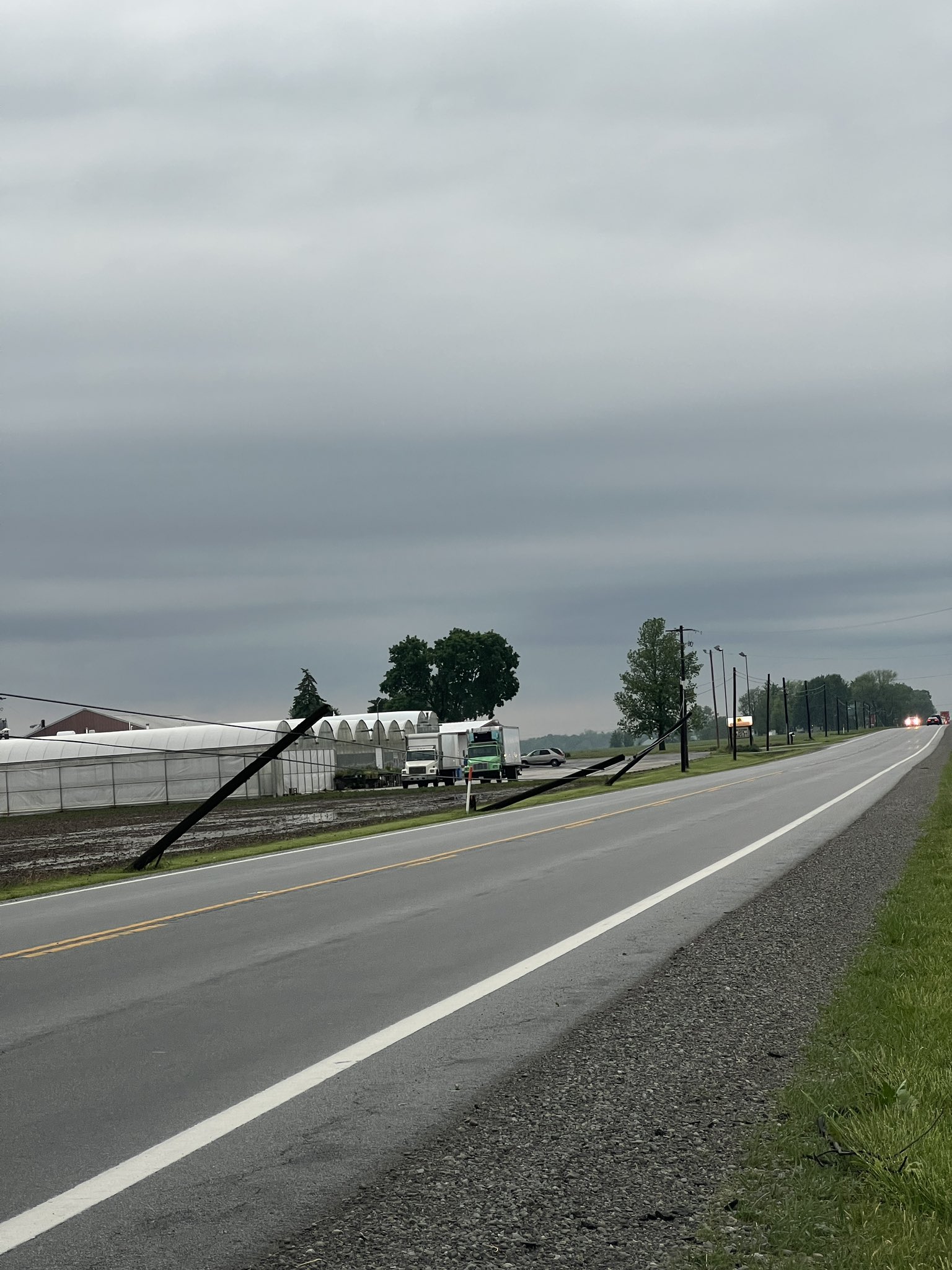
Power Poles Down in Findlay (Davis Wells) |
 |
 |
 |
 |
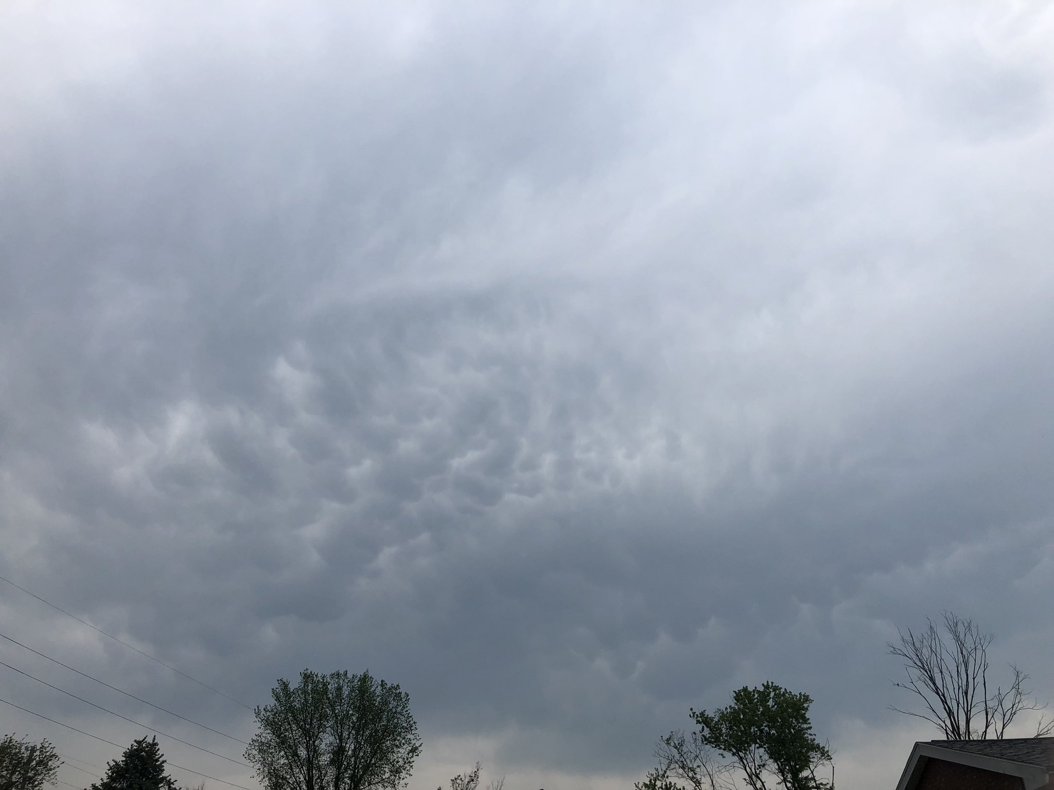
| Mammatus Clouds in Mogadore (Katie McEwen) |
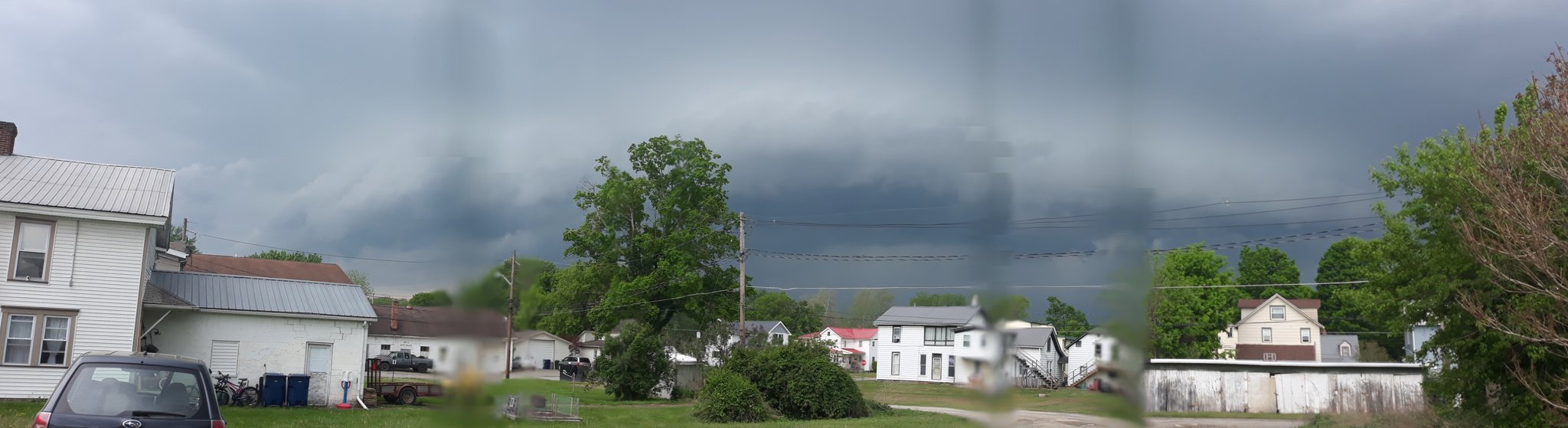
Shelf Cloud North of Mansfield (Irene Carmichael) |
Golf Ball Sized Hail in Chardon - Pleasant Hill Golf Course (James Taylor) |
Tree Down in Poland (Mark Johnson) |
 |
 |
 |
 |
| Golf Ball Sized Hail in Novelty (Emma) |
Lightning Damage to Tree in Mantua (Janis Marie) |
Mammatus Clouds in Akron (Matt) |
Tree Down in Mentor (M Tumarkin) |
 |
 |
 |
 |
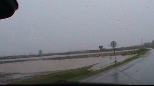
| Flooding in Morral (Eliott) |
Tree Damage east of Attica (Great Lakes Storm Chasing) |
Tree Down in Boardman (Tyler Berry) |
Flooding on Clague Road in North Olmsted (WKYC-TV 3) |
Flooding
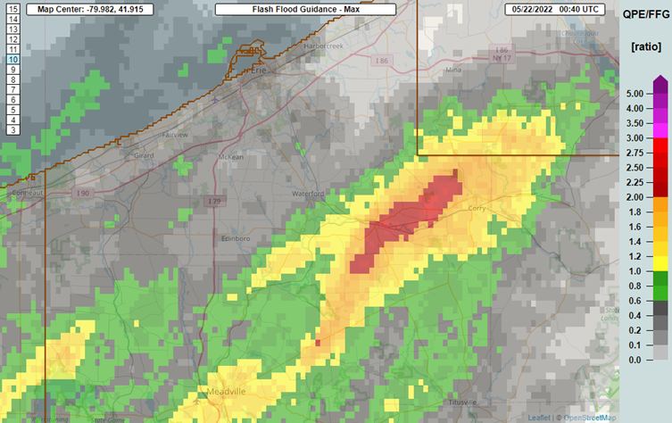
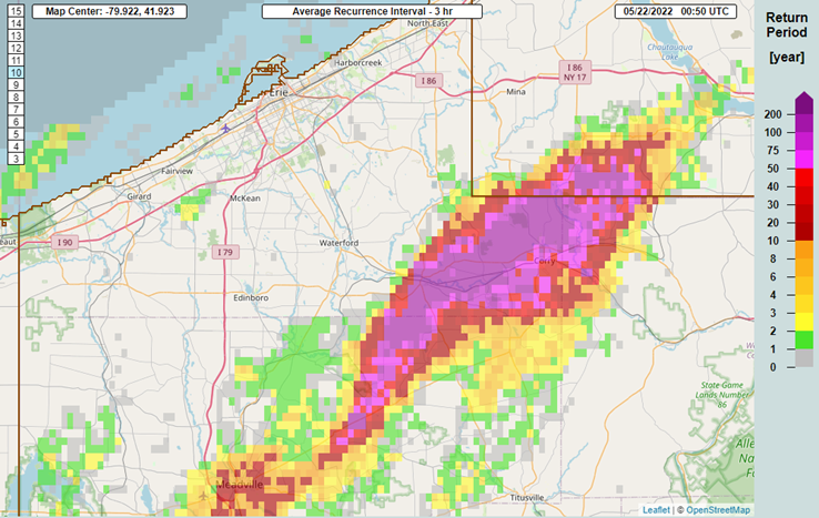
The combination of fairly slow storm motions and higher than average atmospheric moisture for this time of year resulted in areas impacted by heavier storms receiving a quick 1 to 2" of rain from parts of north-central Ohio into northwestern Pennsylvania, resulting in some instances of mainly nuisance flooding. An exception was in parts of Erie and Crawford Counties, PA, where more persistent "training" thunderstorms during the evening of the 21st dropped 3 to 5" of rain in just 2 to 3 hours, especially in parts of eastern Erie County. This resulted in more significant flash flooding, with some roads and bridges damaged by flood waters and with some homes and businesses flooding. Evacuations occurred in Union City, PA due to this flooding. Estimates suggest that the amount of rain that fell in less than a 3-hour period in parts of eastern Erie County were at least a once in 100 year event.
Radar
 |
 |
 |
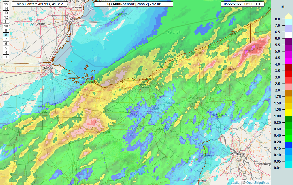 |
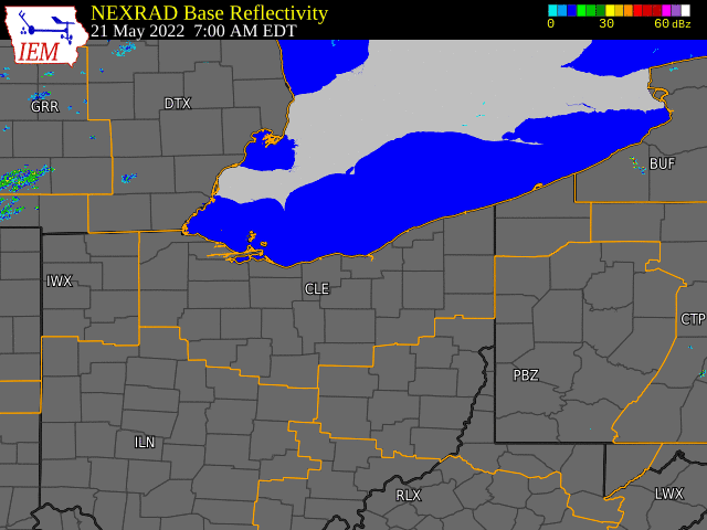
| Regional Radar Loop from 7:00 AM to 11:00 PM EDT May 21, 2022 | MRMS rainfall estimates to flash flood guidance ratios valid the evening of 5/21/2022. Values over 1 indicate enough rainfall that impacted stream/creek basins may experience flooding. Values of up to 2.5 occurred in eastern Erie County. | MRMS expected return interval for radar-estimated rainfall totals for a 3-hour period the evening of 5/21/2022. A large area was estimated to have rainfall amounts in a 3 hour period that occur once every 100-200+ years. | MRMS radar-estimated rainfall (with a gauge correction applied) valid in the 12-hour period ending at 2 AM on 5/22/2022 |
Radar
Thunderstorms across the area during the afternoon and early evening of May 21st produced scattered wind damage and large hail. Large hail was more prevalent early on in the event when cellular storms initially developed. The largest hail occurred in Geauga County, with 2" hail seen south of Chardon! Other reports of golf-ball-sized hail came in from parts of western and central Geauga County. Quarter-sized hail was also reported in parts of Hancock, Richland, and Lake Counties. Some smaller hail was reported elsewhere, especially in the Youngstown area into northwestern Pennsylvania.
As storms gradually congealed into lines through the event, wind damage became the main severe weather hazard. A more potent line of storms briefly acquired bow-echo characteristics as it tracked from Hancock County east-northeast into parts of Wyandot, Marion, Crawford and Huron Counties in northern Ohio. This resulted in several noted instances of tree and power-line damage in this corridor, with some minor structural damage even reported in northern Crawford County. Another area of scattered tree and power-line damage was noted from the eastern Cleveland metro east across parts of Geauga, Portage, Trumbull, and Mahoning Counties, with more significant tree damage reports in parts of Erie and Crawford Counties, PA where straight-line winds of 70-80 MPH were estimated to occur near Cochranton and also north of Edinboro.
|
.net-gifmaker%20(1).gif) |
.png) |
.gif) |
| Regional Radar Loop from 7:00 AM to 11:00 PM EDT May 21, 2022 | Reflectivity and velocity loop from 4:13 PM to 5:56 PM on May 21, 2022 over northwestern and north-central OH. An organized line of storms produced a swath of wind damage across parts of Hancock, Wyandot, Crawford and Huron Counties. It occasionally exhibited a bowing shape, and was at peak intensity as it merged with cells across Crawford and Huron Counties. | Cross section of a storm over central Geauga County shortly before 2" hail was observed. Note the large area of 60+ dBZ, through the entire hail growth layer (0 to -20C), with these values occurring up to 30,000 feet! 60dBZ echoes that high up in a thunderstorm are a sign that very large hail is possible. | 3D radar loop valid 7:40 PM through 8:22 PM, focusing on a line of storms moving into southern Crawford County, PA. Note how the thunderstorm moving from right to left intensifies early on, and then collapses quickly. As this storm collapsed, intense straight-line winds caused significant tree damage near Cochranton, PA. |
Storm Reports
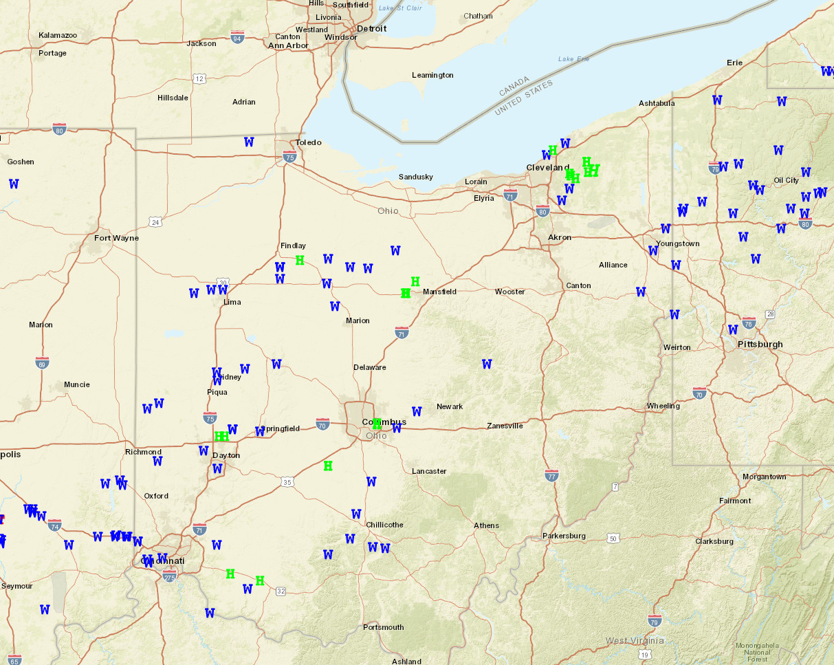
Map of wind damage (blue) and large hail (green) reports across our area from the event. A list of reports is below.
PRELIMINARY LOCAL STORM REPORT...SUMMARY
NATIONAL WEATHER SERVICE CLEVELAND OH
1149 PM EDT MON MAY 23 2022

..TIME...   ...EVENT...      ...CITY LOCATION...     ...LAT.LON...
..DATE...   ....MAG....      ..COUNTY LOCATION..ST.. ...SOURCE....
            ..REMARKS..

0930 AM     TSTM WND GST     4 N WHITEHOUSE          41.58N 83.80W
05/21/2022  M51 MPH          LUCAS              OH   ASOS

            ASOS STATION KTOL TOLEDO.

0954 AM     TSTM WND GST     1 W HARBOR VIEW         41.69N 83.47W
05/21/2022  M40 MPH          LUCAS              OH   BUOY

            BUOY STATION THRO1 TOLEDO, OH.

0954 AM     MARINE TSTM WIND 1 W HARBOR VIEW         41.69N 83.47W
05/21/2022  M40 MPH          LUCAS              OH   BUOY

            35 KNOT PEAK WIND. BUOY STATION THRO1
            TOLEDO, OH.

1010 AM     TSTM WND GST     9 ENE OREGON            41.70N 83.26W
05/21/2022  M53 MPH          LEZ142             OH   MESONET

            MESONET STATION TWCO1 8 ENE OREGON.

0310 PM     HAIL             2 W ONTARIO             40.77N 82.64W
05/21/2022  U0.75 INCH       RICHLAND           OH   PUBLIC

            REPORT FROM MPING: DIME (0.75 IN.).

0311 PM     HAIL             2 W ONTARIO             40.77N 82.64W
05/21/2022  U0.75 INCH       RICHLAND           OH   PUBLIC

            REPORT FROM MPING: DIME (0.75 IN.).

0311 PM     HAIL             2 W ONTARIO             40.77N 82.64W
05/21/2022  U1.00 INCH       RICHLAND           OH   PUBLIC

            REPORT FROM MPING: QUARTER (1.00 IN.).

0312 PM     HAIL             2 W ONTARIO             40.77N 82.65W
05/21/2022  E1.00 INCH       RICHLAND           OH   AMATEUR RADIO


0330 PM     HAIL             5 ESE SHELBY            40.84N 82.57W
05/21/2022  E1.00 INCH       RICHLAND           OH   PUBLIC

            *DELAYED REPORT*.

0348 PM     HAIL             1 SW CLEVELAND          41.47N 81.70W
05/21/2022  U0.75 INCH       CUYAHOGA           OH   PUBLIC

            REPORT FROM MPING: DIME (0.75 IN.).

0354 PM     HAIL             1 WSW CLEVELAND         41.47N 81.70W
05/21/2022  E0.70 INCH       CUYAHOGA           OH   PUBLIC


0354 PM     TSTM WND DMG     1 N EUCLID              41.60N 81.52W
05/21/2022                   CUYAHOGA           OH   PUBLIC

            *DELAYED REPORT* LIMB SNAPPED OFF TREE ON
            BABBITT RD. TIME ESTIMATED VIA RADAR.

0416 PM     HAIL             3 NE SOUTH RUSSELL      41.46N 81.29W
05/21/2022  E1.25 INCH       GEAUGA             OH   FIRE DEPT/RESCUE


0416 PM     HAIL             3 N SOUTH RUSSELL       41.48N 81.33W
05/21/2022  E1.75 INCH       GEAUGA             OH   PUBLIC

            SOCIAL MEDIA REPORT OF GOLF BALL SIZED HAIL
            IN NOVELTY TOWNSHIP.

0419 PM     HAIL             2 S CHESTERLAND         41.49N 81.34W
05/21/2022  E0.70 INCH       GEAUGA             OH   PUBLIC

            DIME SIZE HAIL.

0420 PM     HAIL             2 S CHESTERLAND         41.49N 81.34W
05/21/2022  E1.00 INCH       GEAUGA             OH   PUBLIC


0423 PM     HAIL             1 W CHESTERLAND         41.52N 81.36W
05/21/2022  E0.88 INCH       GEAUGA             OH   PUBLIC


0424 PM     HAIL             RAWSON                  40.96N 83.78W
05/21/2022  U0.75 INCH       HANCOCK            OH   PUBLIC

            REPORT FROM MPING: DIME (0.75 IN.).

0430 PM     HAIL             3 NW BURTON             41.50N 81.19W
05/21/2022  E1.75 INCH       GEAUGA             OH   PUBLIC

            *DELAYED REPORT*.

0433 PM     HAIL             1 SSE CHARDON           41.56N 81.20W
05/21/2022  U1.00 INCH       GEAUGA             OH   PUBLIC

            CORRECTS PREVIOUS HAIL REPORT FROM 1 SSE
            CHARDON. REPORT FROM MPING: QUARTER (1.00
            IN.).

0436 PM     TSTM WND DMG     3 S ARLINGTON           40.86N 83.65W
05/21/2022                   HANCOCK            OH   AMATEUR RADIO

            SEVERAL SMALL TREES AND LARGE LIMBS DOWN.
            UTILITY WIRES DOWN.

0437 PM     TSTM WND DMG     3 N ARLINGTON           40.93N 83.65W
05/21/2022                   HANCOCK            OH   PUBLIC

            CORRECTS PREVIOUS TSTM WND DMG REPORT FROM 3
            N ARLINGTON. SOCIAL MEDIA REPORT OF 3 POWER
            POLES TOPPLED OVER ON US ROUTE 68 BETWEEN
            FINDLAY AND ARLINGTON. TIME ESTIMATED VIA
            RADAR. CORRECTION WAS FOR TIME.

0438 PM     HAIL             3 N BURTON              41.51N 81.14W
05/21/2022  E2.00 INCH       GEAUGA             OH   PUBLIC

            *DELAYED REPORT* OCCURRED ON CLARIDON TROY
            RD BETWEEN ENSIGN AND TAYLOR WELLS.

0450 PM     HAIL             2 E PAINESVILLE         41.73N 81.20W
05/21/2022  U0.75 INCH       LAKE               OH   PUBLIC

            REPORT FROM MPING: DIME (0.75 IN.).

0451 PM     HAIL             VANLUE                  40.97N 83.49W
05/21/2022  E1.00 INCH       HANCOCK            OH   TRAINED SPOTTER


0457 PM     TSTM WND DMG     UPPER SANDUSKY          40.83N 83.28W
05/21/2022                   WYANDOT            OH   AMATEUR RADIO

            MULTIPLE 8 INCH TO 12 INCH DIAMETER TREES
            DOWN AROUND THE CITY.

0507 PM     TSTM WND DMG     5 WNW SYCAMORE          40.98N 83.27W
05/21/2022                   WYANDOT            OH   911 CALL CENTER

            TREE DOWN. TIME ESTIMATED FROM RADAR.

0507 PM     TSTM WND DMG     4 ESE SYCAMORE          40.93N 83.09W
05/21/2022                   CRAWFORD           OH   911 CALL CENTER

            TREE DOWN. TIME ESTIMATED FROM RADAR.

0519 PM     TSTM WND DMG     MORRAL                  40.69N 83.21W
05/21/2022                   MARION             OH   PUBLIC

            LARGE LIMB DOWN.

0530 PM     TSTM WND DMG     2 S CHATFIELD           40.92N 82.95W
05/21/2022                   CRAWFORD           OH   EMERGENCY MNGR

            THUNDERSTORM WIND GUST DOWNED SEVERAL TREES
            MAINLY NORTH OF CR 24 BROKEN SWORD RD IN
            CRAWFORD COUNTY OH AND MAINLY AROUND
            CHATFIELD. A CARPORT WAS DAMAGED, GAS
            STATION AWNING WAS BLOWN DOWN, AND TREE WAS
            BLOWN OVER ON A METAL SHED.

0539 PM     TSTM WND DMG     2 SSW WILLARD           41.03N 82.73W
05/21/2022                   HURON              OH   STORM CHASER

            STORM CHASER VIDEO SHOWS TREES AND POWER
            LINES DOWNED ON OHIO STATE ROUTE 103 SOUTH
            OF WIERS ROAD IN CELERYVILLE.

0544 PM     HAIL             TIRO                    40.91N 82.77W
05/21/2022  E0.70 INCH       CRAWFORD           OH   TRAINED SPOTTER

            DIME SIZE HAIL.

0556 PM     TSTM WND DMG     CORRY                   41.92N 79.64W
05/21/2022                   ERIE               PA   BROADCAST MEDIA

            SEVERAL TREES DOWN. PEA SIZE HAIL ALSO. TIME
            ESTIMATED FROM RADAR.

0600 PM     HEAVY RAIN       1 S MONROEVILLE         41.23N 82.70W
05/21/2022  M2.00 INCH       HURON              OH   TRAINED SPOTTER


0627 PM     MARINE TSTM WIND 3 N CLEVELAND           41.52N 81.68W
05/21/2022  M41 MPH          CUYAHOGA           OH   ASOS

            CORRECTS PREVIOUS MARINE TSTM WIND REPORT
            FROM 3 N CLEVELAND. 36 KNOT PEAK WIND. ASOS
            STATION KBKL CLEVELAND. CORRECTED FOR TIME.

0630 PM     TSTM WND DMG     BOARDMAN                41.03N 80.67W
05/21/2022                   MAHONING           OH   BROADCAST MEDIA

            *DELAYED REPORT* SEVERAL TREES AND LARGE
            BRANCHES DOWN IN THE BOARDMAN AREA.

0636 PM     MARINE TSTM WIND 2 WSW BRATENAHL         41.54N 81.64W
05/21/2022  M39 MPH          LEZ146             OH   C-MAN STATION

            C-MAN STATION CNDO1 CLEVELAND, OH MEASURED A
            34 KT MARINE THUNDERSTORM WIND GUST.

0638 PM     HAIL             WILLOWICK               41.63N 81.47W
05/21/2022  E1.00 INCH       LAKE               OH   PUBLIC

            *DELAYED REPORT*.

0649 PM     TSTM WND DMG     REMINDERVILLE           41.33N 81.40W
05/21/2022                   SUMMIT             OH   NWS EMPLOYEE

            *DELAYED REPORT* SEVERAL LARGE TREE BRANCHES
            DOWN.

0650 PM     TSTM WND DMG     BAINBRIDGE              41.40N 81.34W
05/21/2022                   GEAUGA             OH   FIRE DEPT/RESCUE

            *DELAYED REPORT* TREES AND WIRES DOWN ON
            OH-306 BETWEEN LUCERNE DR AND TRILIUM DR.

0654 PM     MARINE TSTM WIND 1 NNW FAIRPORT HARBOR   41.76N 81.28W
05/21/2022  M41 MPH          LAKE               OH   C-MAN STATION

            C-MAN STATION FAIO1 FAIRPORT, OH MEASURED A
            36 KT MARINE THUNDERSTORM WIND GUST.

0655 PM     TSTM WND GST     2 SW MENTOR             41.67N 81.37W
05/21/2022  M58 MPH          LAKE               OH   AWOS

            AWOS STATION KLNN WILLOUGHBY LOST NATION
            AIRPORT MEASURED A 50 KT THUNDERSTORM WIND
            GUST.

0711 PM     HAIL             4 S LORDSTOWN           41.11N 80.88W
05/21/2022  U0.75 INCH       MAHONING           OH   PUBLIC

            REPORT FROM MPING: DIME (0.75 IN.).

0730 PM     MARINE TSTM WIND 2 W GENEVA-ON-THE-LAKE  41.86N 80.97W
05/21/2022  M41 MPH          LEZ147             OH   MESONET

            36 KNOT PEAK WIND. MESONET STATION GELO1 1 W
            GENEVA-ON-THE-LAKE.

0736 PM     HAIL             GIRARD                  41.15N 80.70W
05/21/2022  E0.70 INCH       TRUMBULL           OH   AMATEUR RADIO

            DIME SIZE HAIL.

0737 PM     TSTM WND DMG     HUBBARD                 41.16N 80.57W
05/21/2022                   TRUMBULL           OH   PUBLIC

            *DELAYED REPORT* TWO LARGE TREE BRANCHES
            DOWN, ONE OF WHICH IS ON A POWERLINE AND
            BLOCKING A ROAD.

0743 PM     HEAVY RAIN       CONNEAUT                41.93N 80.57W
05/21/2022  M1.30 INCH       ASHTABULA          OH   TRAINED SPOTTER

            RAINFALL IN ONE HALF HOUR.

0808 PM     TSTM WND DMG     3 WNW COCHRANTON        41.53N 80.11W
05/21/2022                   CRAWFORD           PA   911 CALL CENTER

            SEVERAL TREES DOWN.

0810 PM     TSTM WND DMG     5 NNW EDINBORO          41.93N 80.16W
05/21/2022                   ERIE               PA   EMERGENCY MNGR

            WEST ERIE COUNTY EMA REPORTED DAMAGE DUE TO
            THUNDERSTORM WINDS NORTH OF EDINBORO IN THE
            VICINITY OF OLD STATE ROAD AND FRY ROAD.
            DAMAGE INCLUDED METAL ROOF AND LARGE METAL
            SILO DISPLACEMENT, MULTIPLE HOMES WITH
            SIDING DAMAGE, LARGE TREES SNAPPED AND
            UPROOTED, AND LEANING UTILITY POLES. TIME
            ESTIMATED VIA RADAR.

0814 PM     TSTM WND DMG     3 NE COCHRANTON         41.55N 79.99W
05/21/2022                   CRAWFORD           PA   EMERGENCY MNGR

            THUNDERSTORM WIND GUST SNAPPED AND DOWNED
            SEVERAL TREES AROUND THE INTERSECTION DEETER
            ROAD AND COTTERMAN ROAD AND WIDE PATH OF
            TREE DAMAGE ENE TO NEAR THE INTERSECTION OF
            SUGAR LAKE ROAD AND KLEIN WAY.

0835 PM     TSTM WND DMG     TITUSVILLE              41.63N 79.67W
05/21/2022                   CRAWFORD           PA   NEWSPAPER

            *DELAYED REPORT* LARGE TREE UPROOTED ON
            FRANKLIN ST.

0907 PM     HEAVY RAIN       3 NW ELGIN              41.95N 79.78W
05/21/2022  M3.71 INCH       ERIE               PA   TRAINED SPOTTER

            RAINFALL IN 4 HOURS.

0944 PM     FLASH FLOOD      UNION CITY              41.90N 79.85W
05/21/2022                   ERIE               PA   EMERGENCY MNGR

            ERIE COUNTY REPORTED EVACUATIONS ARE
            OCCURRING IN THE AREA OF NORTH MAIN AND
            WATERFORD STREETS AND SOUTH MAIN AND PARADE
            STREETS IN UNION CITY BOROUGH DUE TO
            FLOODING.


&&

$$

SEFCOVIC
Environment
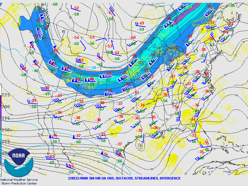
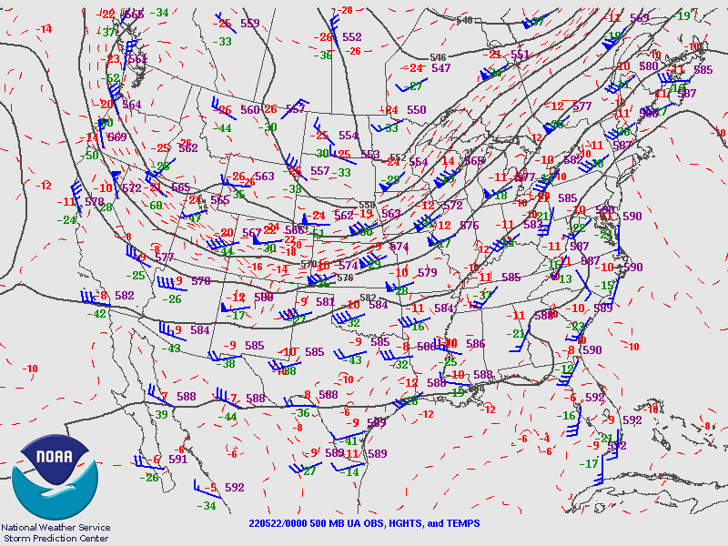
An approaching cold front helped trigger thunderstorms during the afternoon and evening on May 21, 2022, along with outflow boundaries from thunderstorms that glanced the region earlier in the day. The core of the upper-level jet stream (seen at 300mb and 500mb below) did stay to our northwest, but the jet got just close enough to give us some modest wind shear (change in wind speed/direction with height) and to enhance lift across the region, which resulted in us seeing thunderstorms that were more persistent and organized that the typical "popcorn" or "pulse" thunderstorms we see on a regular humid day in the summer.
The amount of jet support and wind shear were relatively modest, but the thermodynamics (temperature and moisture profiles) were quite a bit more favorable for severe weather. Dew points in the mid 60s combined with air temperatures warming well into the 80s with daytime heating set the stage for an unstable atmosphere. An "elevated mixed layer" (or EML) developed over the higher terrain of western North America and worked its way overhead for this event. This EML led to dry mid-level air and steep mid-level "lapse rates", meaning temperatures cooled quickly with height. As warm, humid air was lifted by thunderstorms through the cool, dry mid-levels, it favored strong updrafts and downdrafts with the storms...basically, it increased the threats for both damaging winds and large hail. We typically see an EML make it this far east no more than a few times per year, and when it does happen severe weather often accompanies it.
Large Scale Environment:
 |
 |
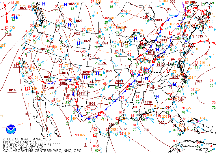 |
| 300mb objective analysis, courtesy of the SPC, valid at 8 PM on 5/21/2022. While the stronger winds aloft are well to our northwest, they glance northern Ohio. Also, a weak upper-low is evident over the Ohio Valley, which may have added some lift and helped thunderstorm development. | 500mb objective analysis, courtesy of the SPC, valid at 8 PM on 5/21/2022. Stronger winds at this level are just glancing northern Ohio, with some signs of a subtle trough or vort max over the upper Ohio Valley | Surface analysis, courtesy of the WPC, valid at 5 PM on 5/21/2022, showing a cold front slowly moving in from the northwest. |
Near-storm environment summary:
 |
 |
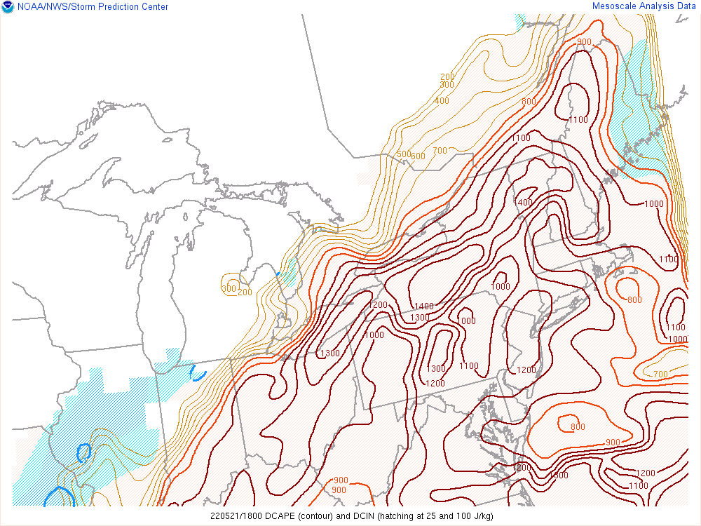 |
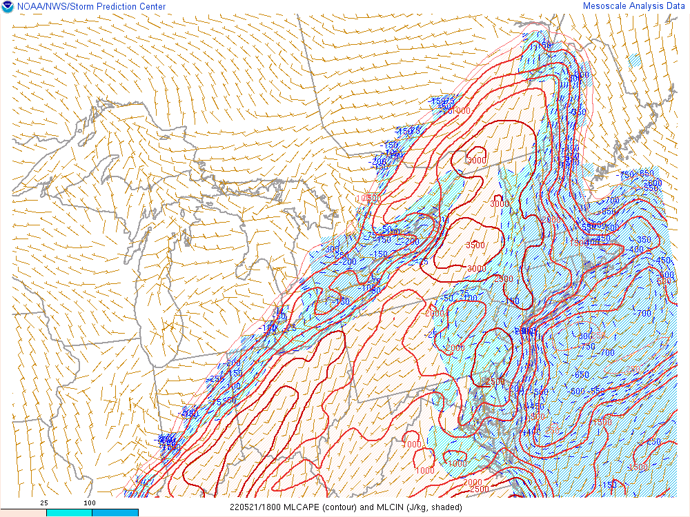
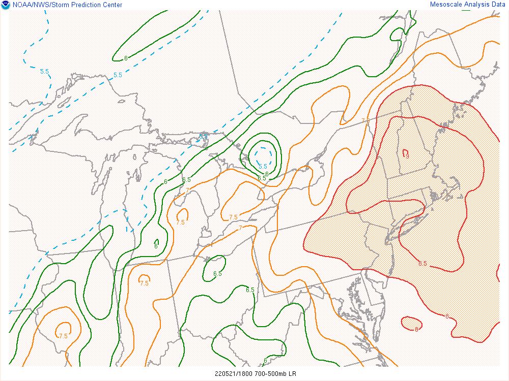
| Mesoanalysis loop of mixed-layer CAPE, valid 2-8 PM on 5/21/2022, courtesy of the SPC. Values of 2000-3000 J/KG were initially common, before gradually subsiding into the evening. These values are high for this region, and indicated an environment ripe for strong thunderstorm updrafts. | Mesoanalysis loop of 500-700mb lapse rates (temperature change with height), valid 2-8 PM on 5/21/2022, courtesy of the SPC. Values of initially over 7C/km gradually diminished into the evening, but indicate the presence of an "elevated mixed layer", which enhanced both the large hail and damaging wind threat with stronger thunderstorms. | Mesoanalysis loop of downdraft CAPE (negative bouyancy available for downdrafts to accelerate), valid 2-8 PM on 5/21/2022, courtesy of the SPC. Values of 1000-1300 J/KG were fairly common until the evening hours, which suggested a very favorable environment for damaging thunderstorm wind gusts. |
 |
.gif) |
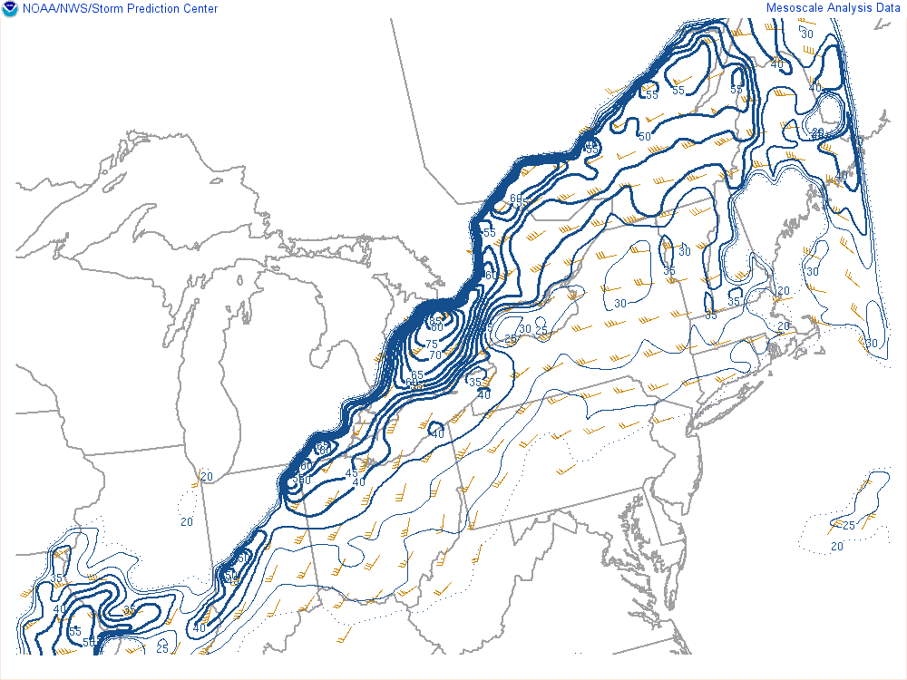 |
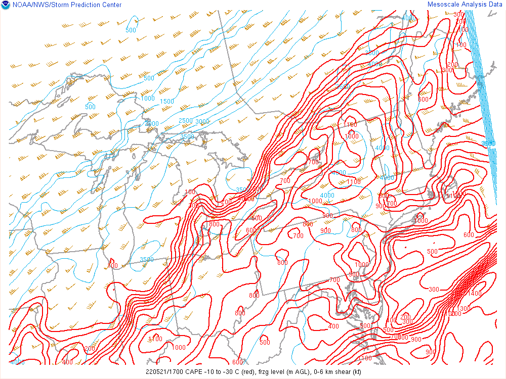
| Mesoanalysis loop of "hail parameters", valid 1-8 PM on 5/21/2022, courtesy of the SPC. This plot shows the amount of instability (red contours) in the layer of the atmosphere where hail develops, along with deep-layer wind shear (wind barbs) and the freezing level (thin blue contours, in meters). The freezing level was fairly high and deep-layer shear was a bit marginal, but very strong instability existed in the hail growth layer thanks to the EML. | Mesoanalysis loop of 0-3km above ground level lapse rates (temperature change with height), valid 2-8 PM on 5/21/2022, courtesy of the SPC. Values of 7-8+ C/km indicated an environment favorable for strong thunderstorm winds to make it to the surface, which helped increase the risk for damaging wind. | Mesoanalysis loop of the effective deep-layer shear, valid 2-8 PM on 5/21/2022, courtesy of the SPC. Values of 25-35 knots were common ahead of the advancing cold front where storms occurred. This is just enough shear for some amount of organization to the storms, which helped contribute to an organized severe threat. |
Additional environmental data.
 |
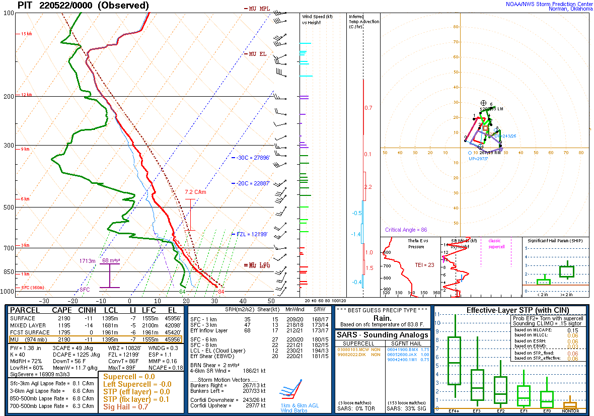 |
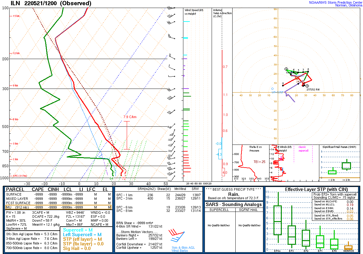
| Observed upper-air sounding from Wilmington, OH from 8 AM on 5/21/2022. While cool temperatures near the surface and a cap just below 700mb exist in this sounding, note the quickly cooling and drying mid-levels of the atmosphere due to the EML. As the surface heated up and the cap weakened in the afternoon, the EML encouraged strong to severe thunderstorms with wind damage and hail potential. | Observed upper-air sounding from Pittsburgh, PA from 8 PM on 5/22/2022. Note that the cap in place on the Wilmington sounding in the morning has eroded, with signs of an EML still in place with cooler and drier air in the mid-levels. |
 |
Media use of NWS Web News Stories is encouraged! Please acknowledge the NWS as the source of any news information accessed from this site. |
|

