Overview
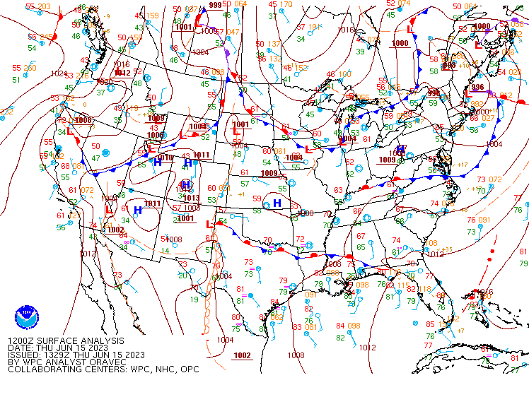
| A cold front moved into northwest Ohio the evening of Thursday, June 15. A weak surface low pressure developed along this front over southern Michigan earlier in the day and moved southeast across the western tip of Lake Erie during the evening. A warm front extended southeast of this low pressure along the western Lake Erie shoreline and then down towards central Ohio. Thunderstorms erupted along the cold front near Toledo just before 6:00 PM and moved southeast towards east-central Ohio over the coming hours. Enhanced shear associated with the low pressure, warm front, and lake breeze boundary near the western lakeshore allowed storms to rotate. A particularly intense supercell (rotating thunderstorm) developed near the Ohio/Michigan border just north of Toledo and tracked across parts of Lucas, Ottawa, Sandusky, Erie, Huron, Seneca, Richland, Ashland, and Wayne Counties. This supercell was responsible for 12 tornadoes and numerous instances of large hail, with hail to at least the size of tennis balls reported near Toledo and multiple reports of hail to golf ball sized or larger as the storm continued southeast. Storms gradually congealed into a line that produced some hail and straight line wind damage into east central Ohio. | .gif) Radar loop and NWS warnings from the evening of June 15, 2023. Loop courtesy of Iowa State. |
Tornadoes:
|
Toledo Tornado
|
||||||||||||||||
|
Maumee Bay State Park Tornado
|
||||||||||||||||
|
Oak Harbor Tornado
|
||||||||||||||||
|
Rice Township Tornado
|
||||||||||||||||
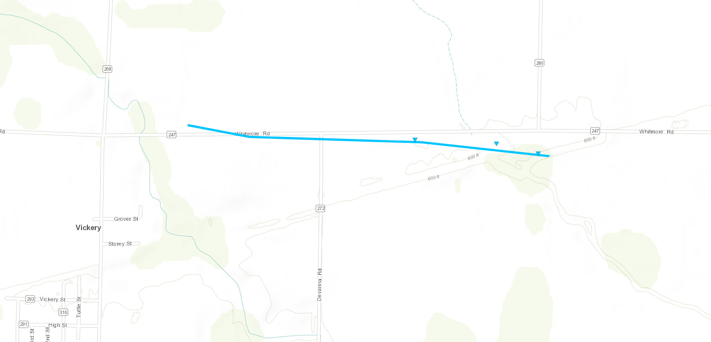
|
Vickery Tornado
|
||||||||||||||||
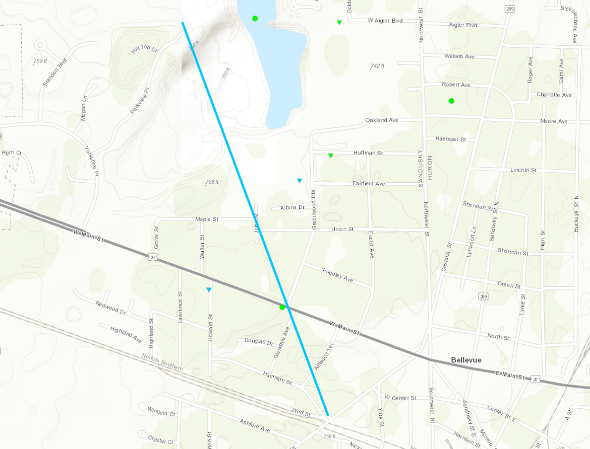
|
Bellevue Tornado
|
||||||||||||||||
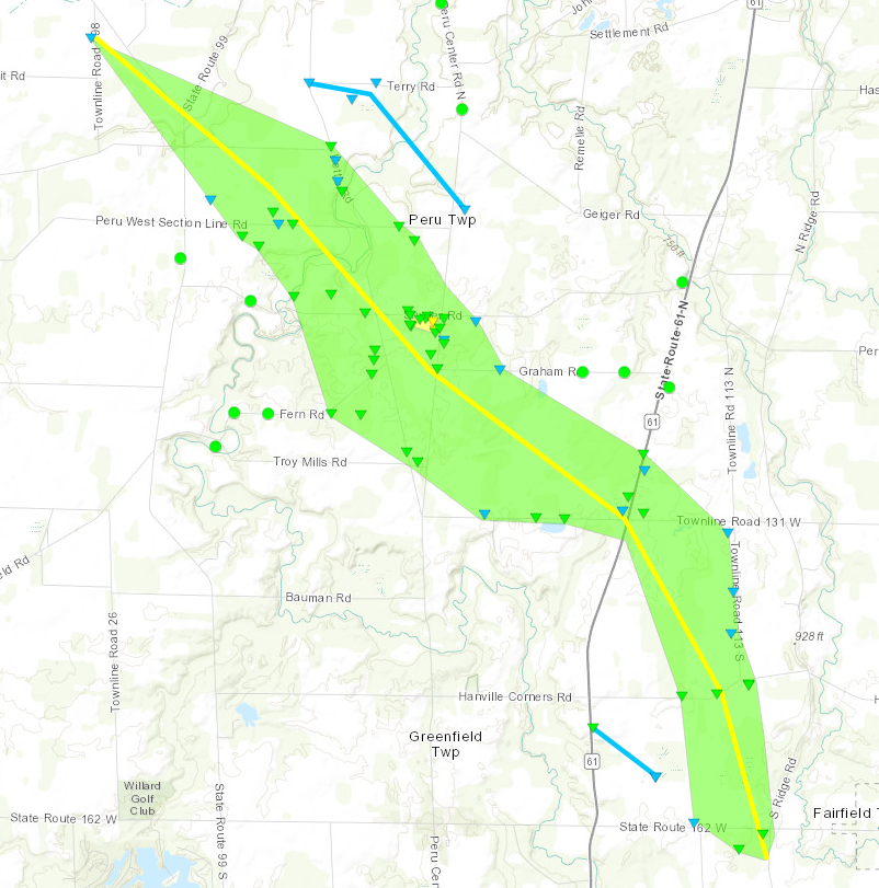
|
Peru Township Tornado
|
||||||||||||||||
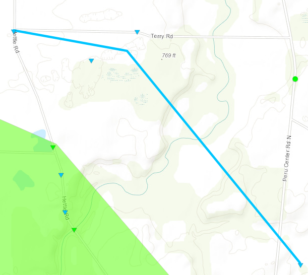
|
Northeast Peru Township Tornado
|
||||||||||||||||
|
East Greenfield Township Tornado
|
||||||||||||||||
|
North Fairfield Tornado
|
||||||||||||||||
|
Greenwich Tornado
|
||||||||||||||||
|
Nankin Tornado
|
||||||||||||||||
The Enhanced Fujita (EF) Scale classifies tornadoes into the following categories:
| EF0 Weak 65-85 mph |
EF1 Moderate 86-110 mph |
EF2 Significant 111-135 mph |
EF3 Severe 136-165 mph |
EF4 Extreme 166-200 mph |
EF5 Catastrophic 200+ mph |
 |
|||||
Hail:
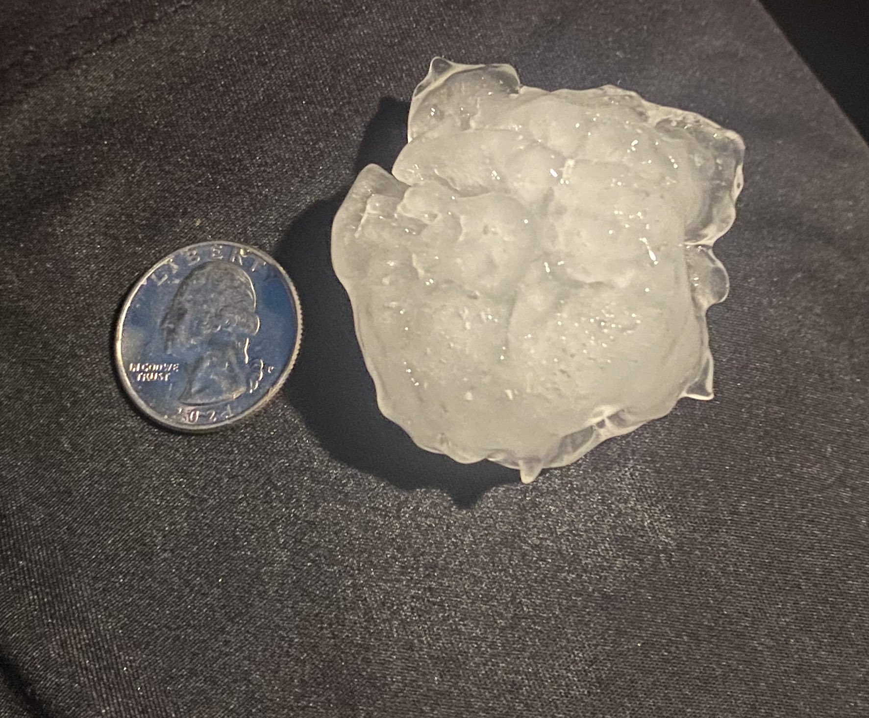
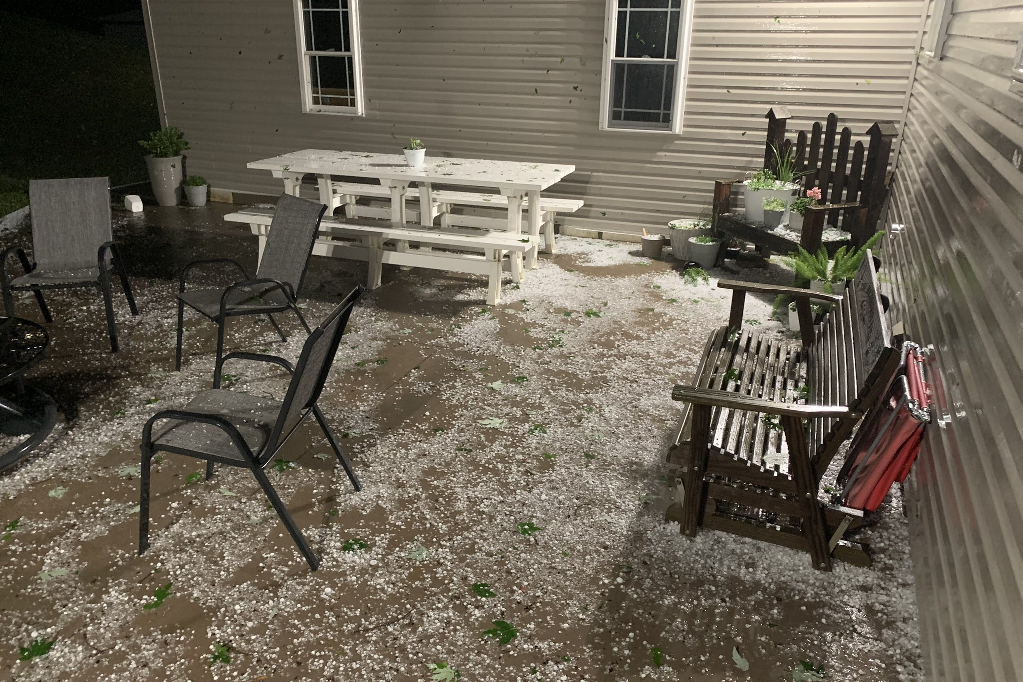
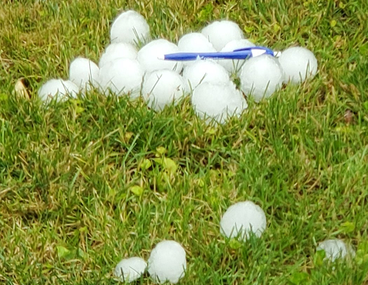
The long tracked supercell thunderstorm produced a swath of large hail from eastern Lucas County southeast across parts of Ottawa, Sandusky, Erie, Huron, northern Richland, Ashland and Wayne Counties with numerous reports of hail larger than golf ball sized. The largest hail occurred in eastern Lucas County, with reports of hail near baseball sized in locations such as the Point Place neighborhood in Toledo, Harbor View, and the Cedar Point Wildlife Refuge. Hail larger than 2" in diameter was also reported in northern Ashland County. Another thunderstorm produced quarter to golf ball sized hail in Seneca County.
 |
 |
 |
 |
| Hail exceeding 2" fell in Bailey Lakes. (MWC Weather) |
Hail exceeding 2" fell in Bailey Lakes. (MWC Weather) |
Hail larger than 2" in diameter fell in the Toledo area. (Gregg Hart) |
Golf ball size or larger hail fell in Toledo. (Steve Pietras) |
 |
 |
 |
 |
| Quarter size hail fell in Bellevue. (Steven Shuttlesworth) |
Hail damaged a vehicle in Harbor View. (@Doggo/Twitter) |
Hail near tennis ball sized in Harbor View. (@Doggo/Twitter) |
Hail near baseball sized in the Point Place neighborhood of Toledo. (@aaronjmarcum/Twitter) |
 |
 |
 |
 |
| Golf ball sized hail in Bellevue. (Justin Walters) |
Copious amounts of hail covered the ground and damaged vegetation in Walnut Creek, OH. (Mark Hochstetler) |
Numerous hail stones at least the size of golf balls near Lake Erie in Toledo. (@FGrimvault/Twitter) |
A hail-damaged windshield in the Point Place neighborhood of Toledo. (Timothy Albertson) |
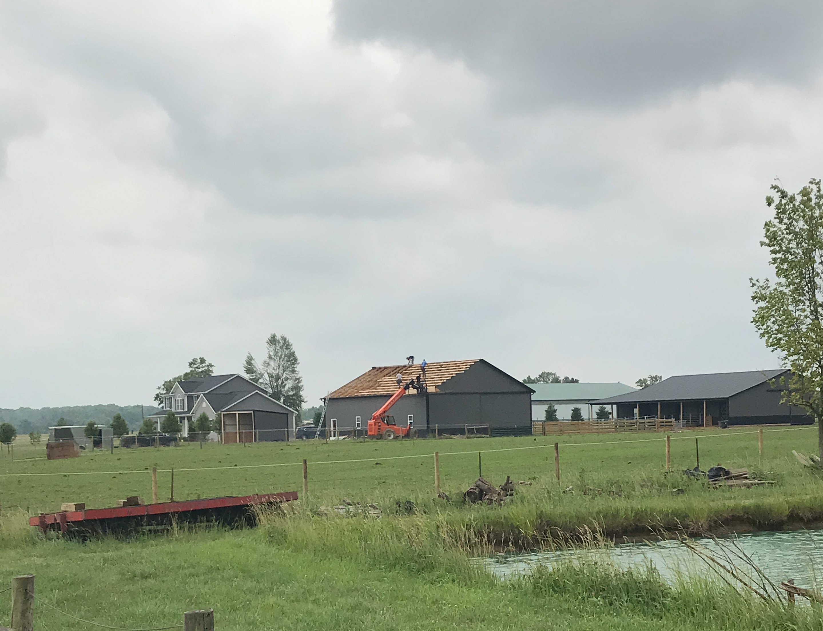
Photos & Video
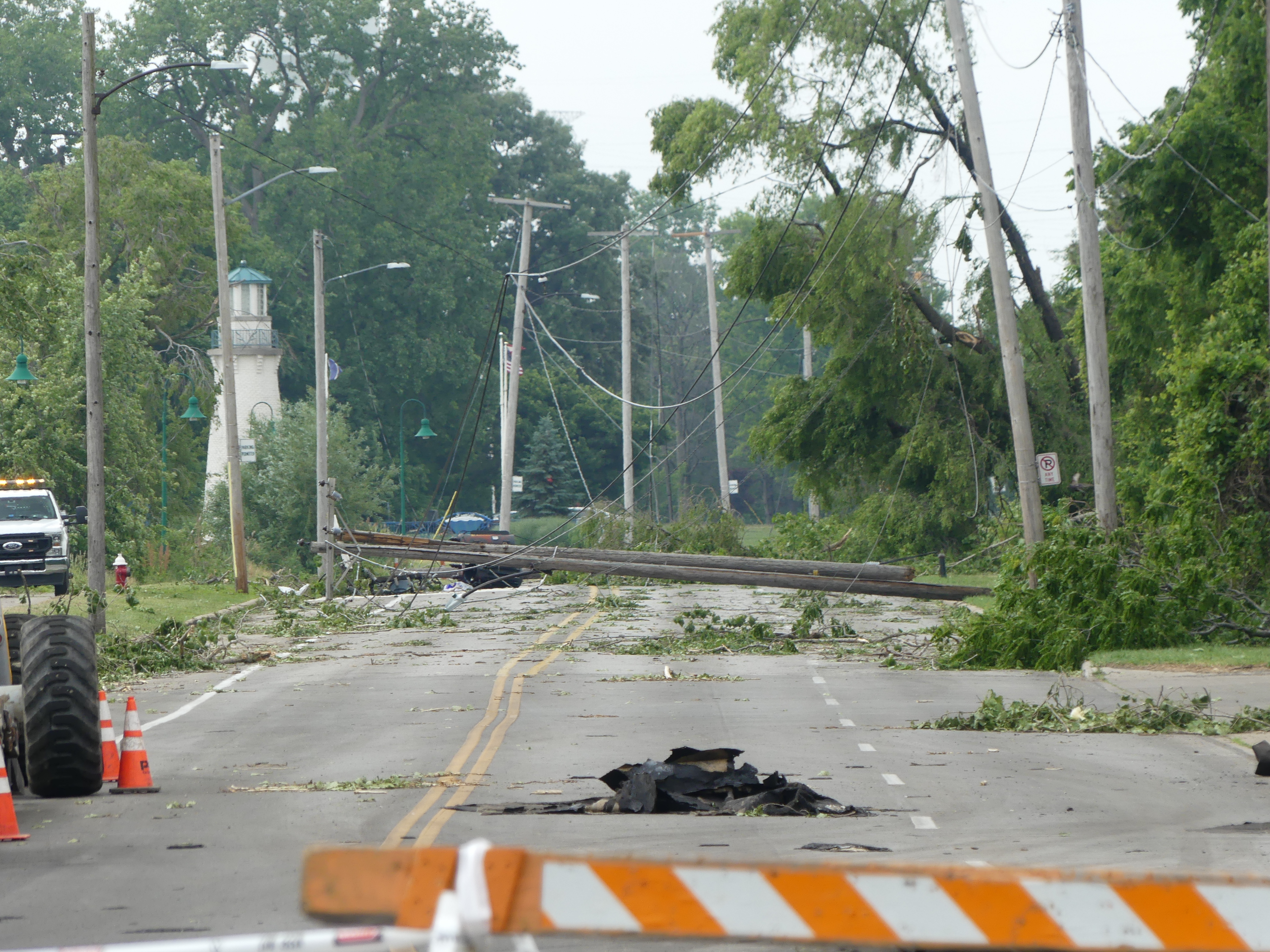
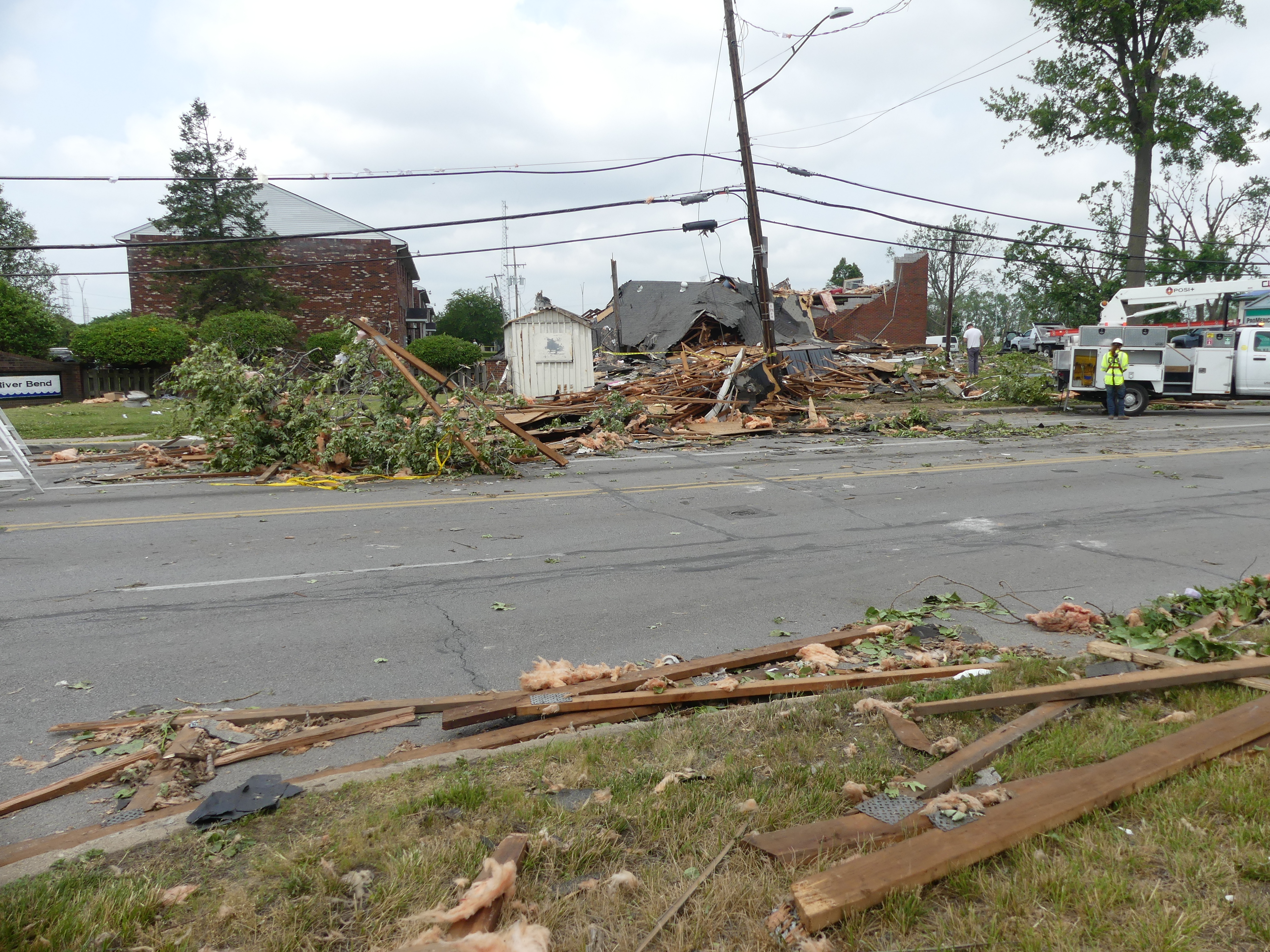
Toledo Tornado
 |
 |
 |
 |
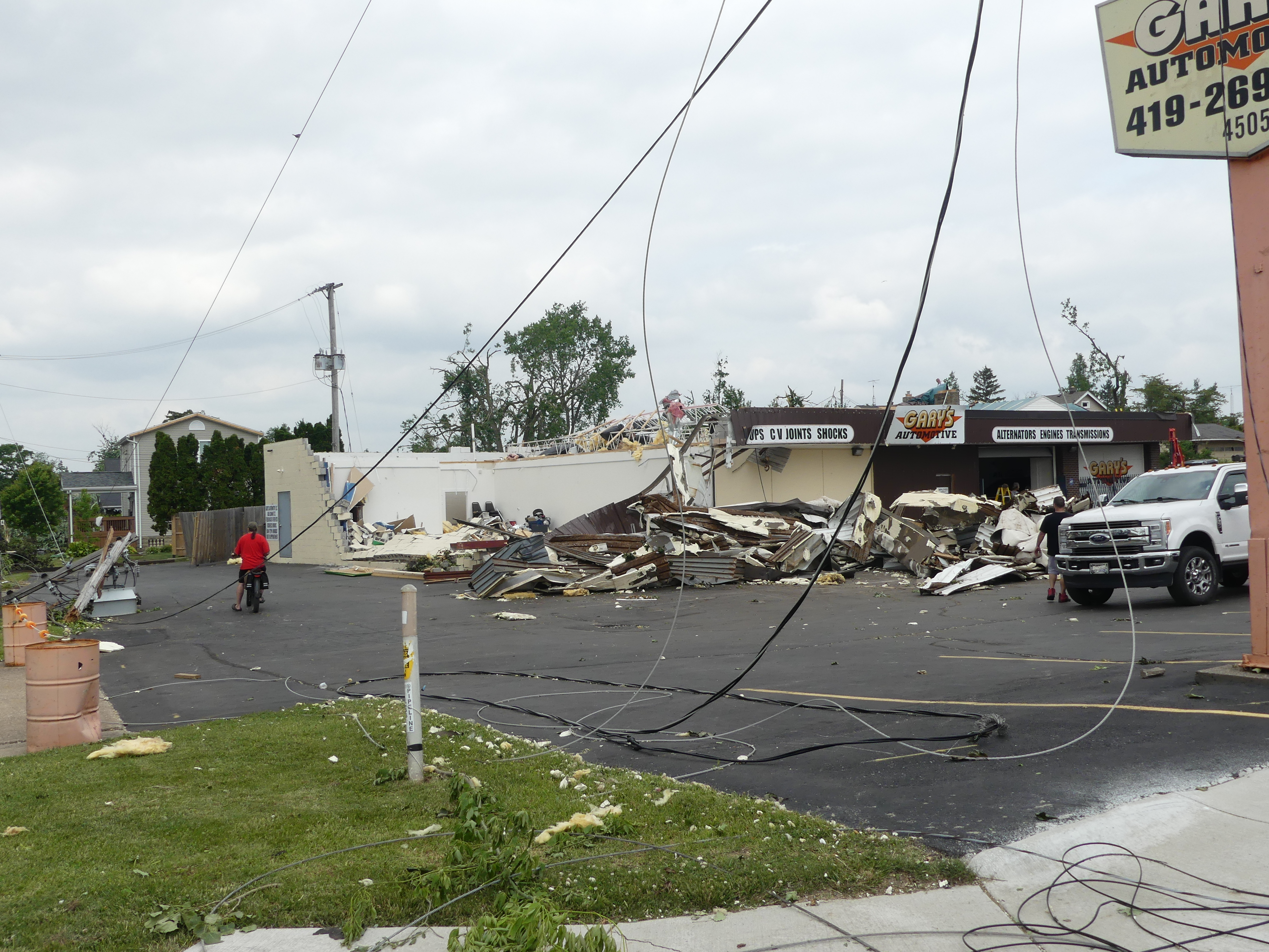
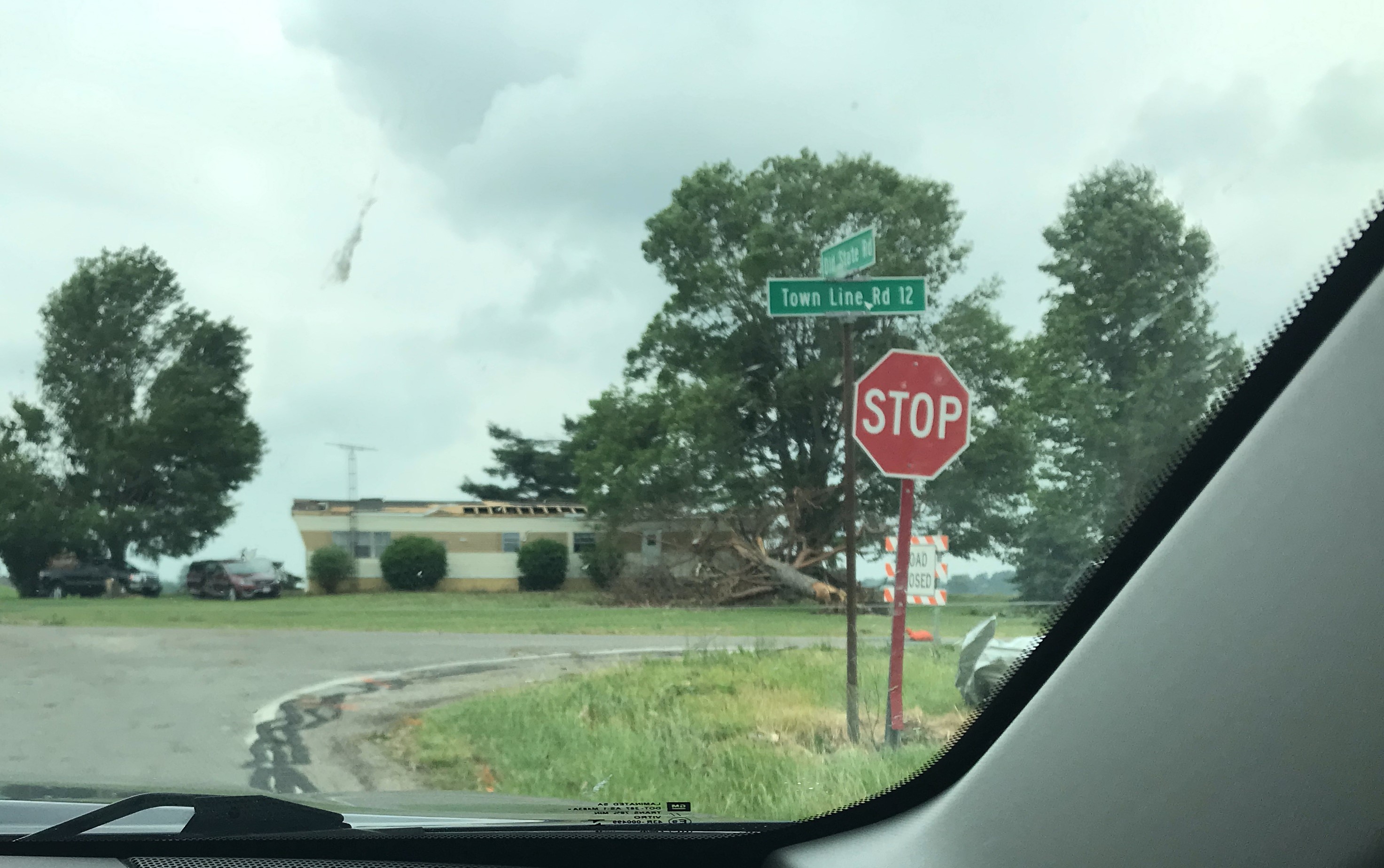
| Damage to automotive shop, including damage to roof and exterior walls. (NWS Storm Survey) |
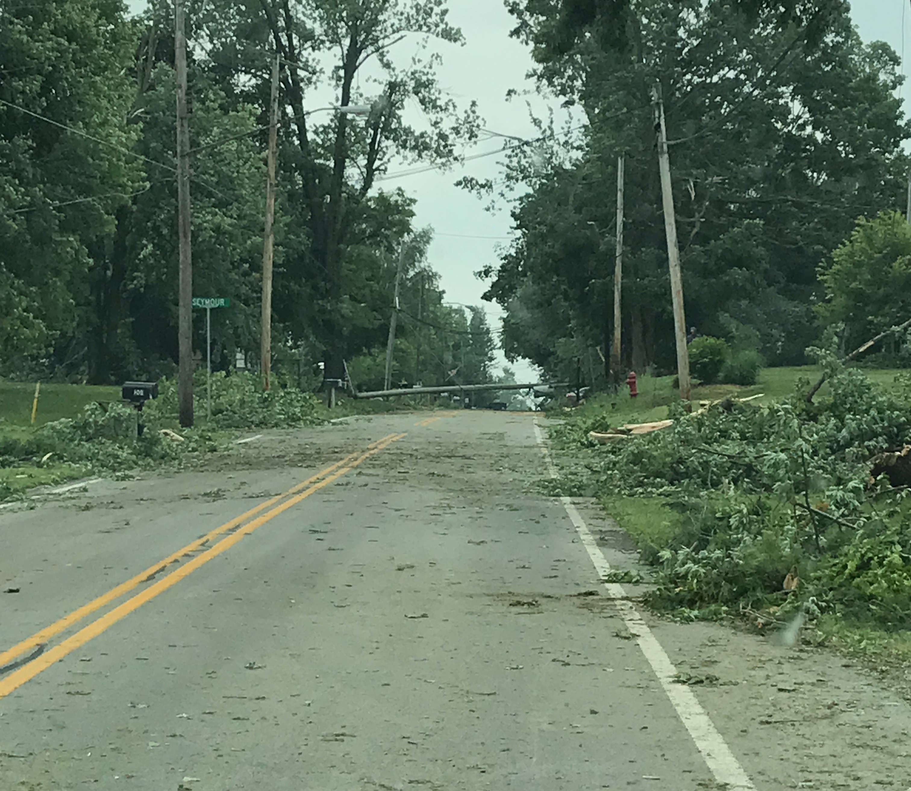
Mangled trees and snapped power poles in northern Toledo. (NWS Storm Survey) |
Damage to a medical building in Point Place, including complete removal of the roof and exterior walls on the second floor. (NWS Storm Survey) |
Extensive tree and powerline damage in northern Toledo. (NWS Storm Survey) |
 |
 |
 |
 |
| Closer view of the medical building that was heavily damaged in the Point Place neighborhood. (NWS Storm Survey) |
Extensive tree damage in northern Toledo. (NWS Storm Survey) |
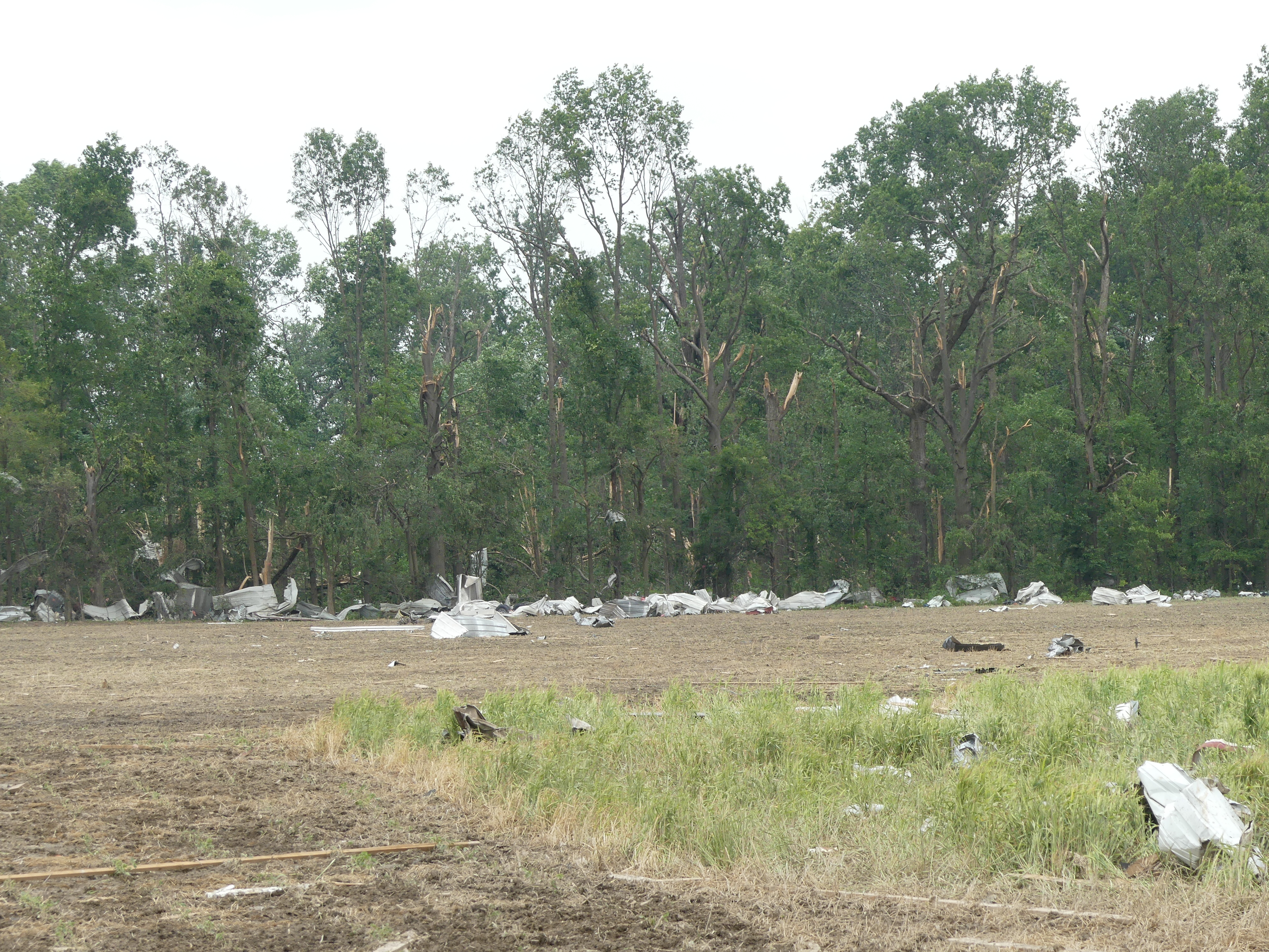
Tree damage and debris strewn across a field near Maumee Bay. (NWS Storm Survey) |
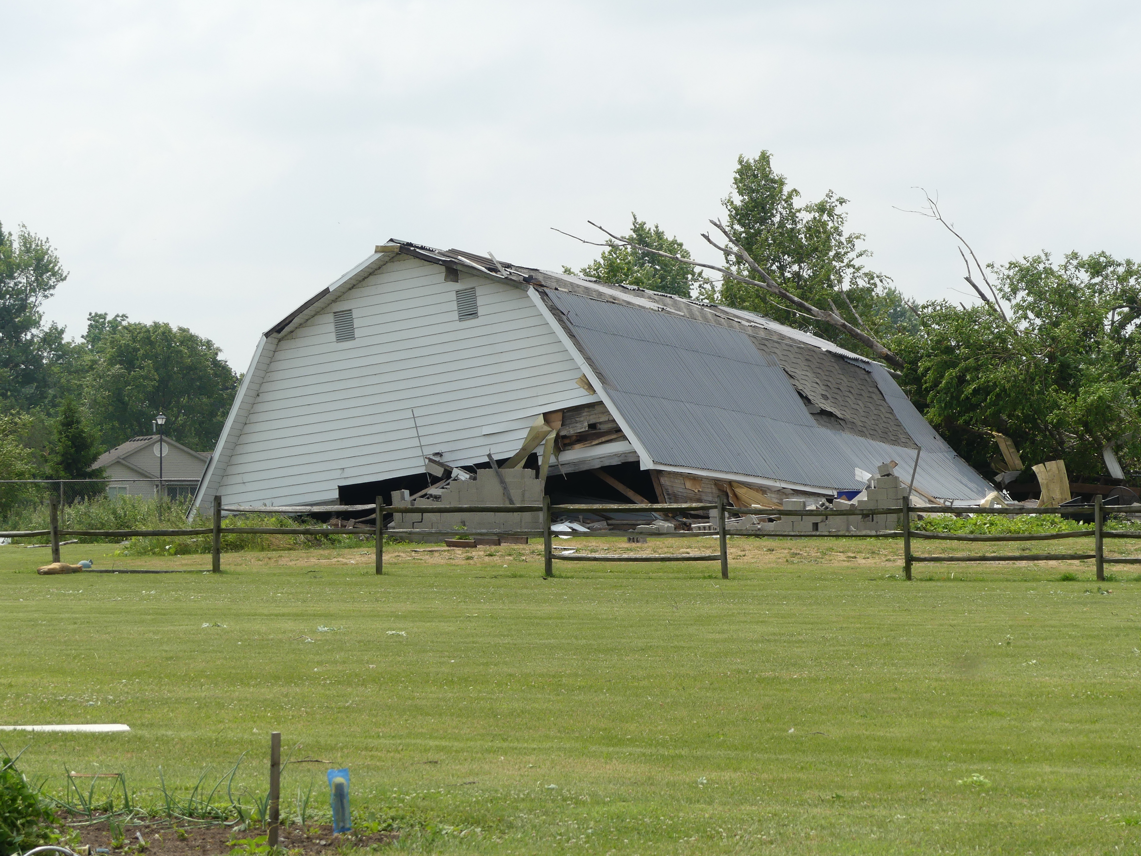
Heavily damaged barn in northern Toledo. (NWS Storm Survey) |
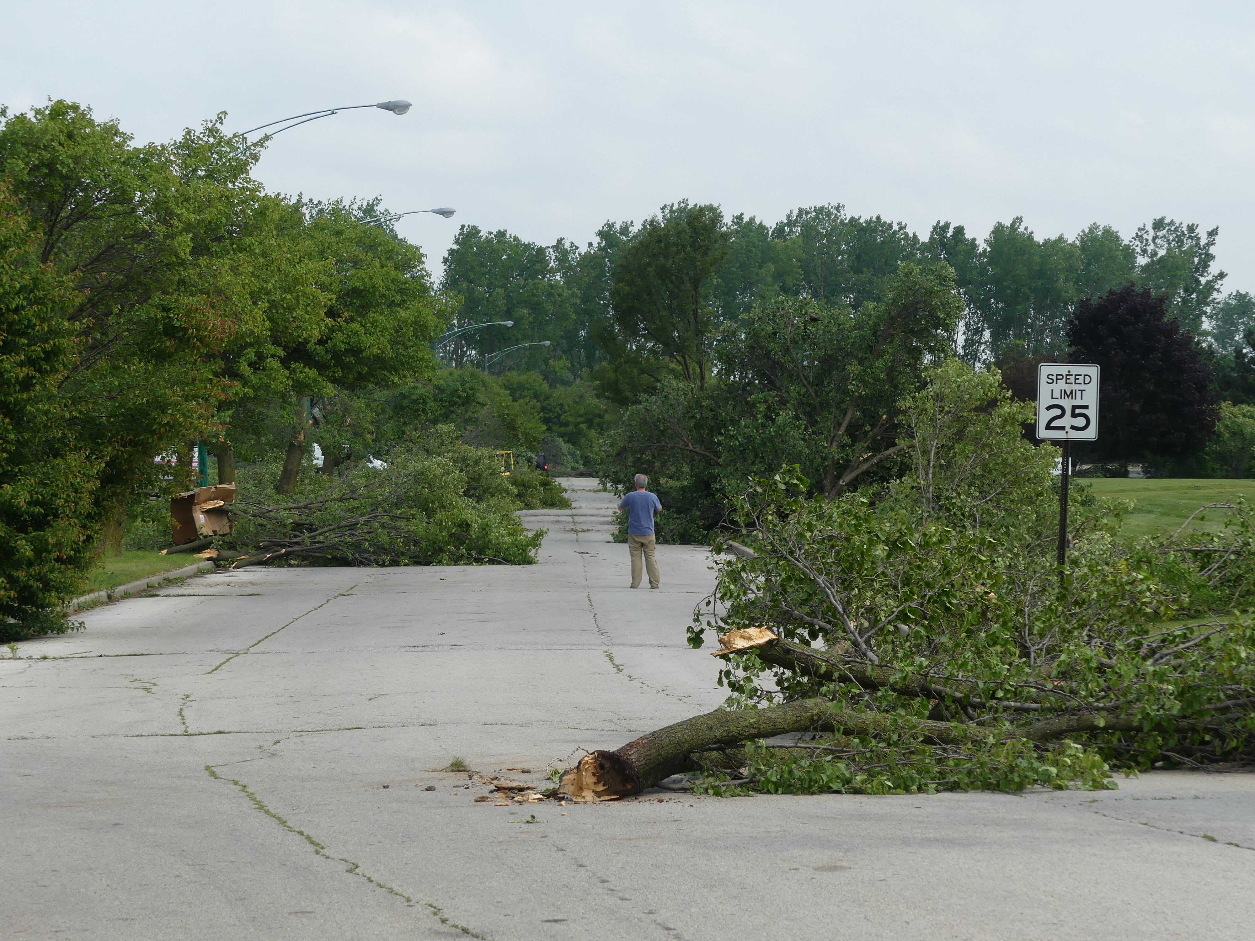
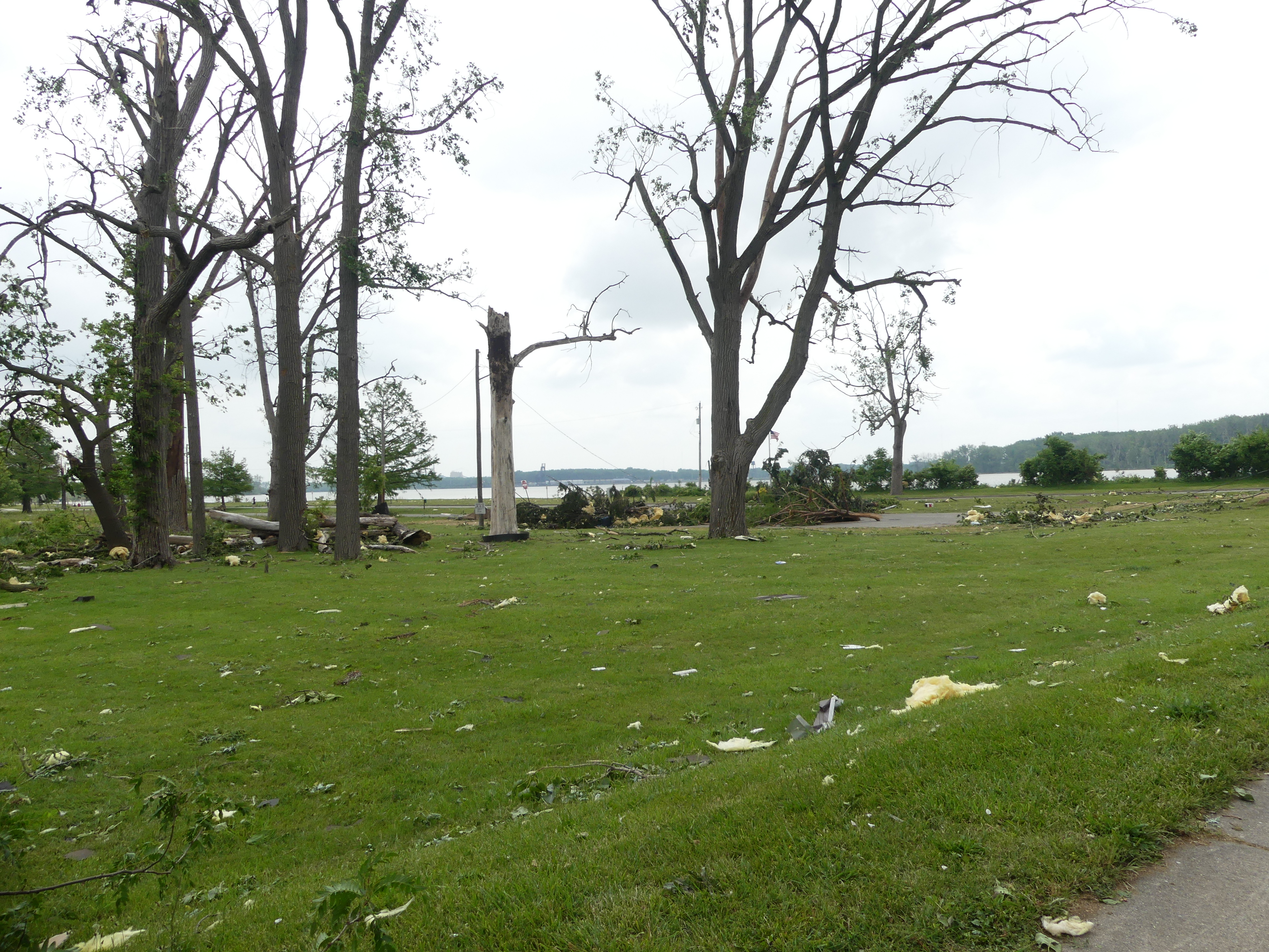
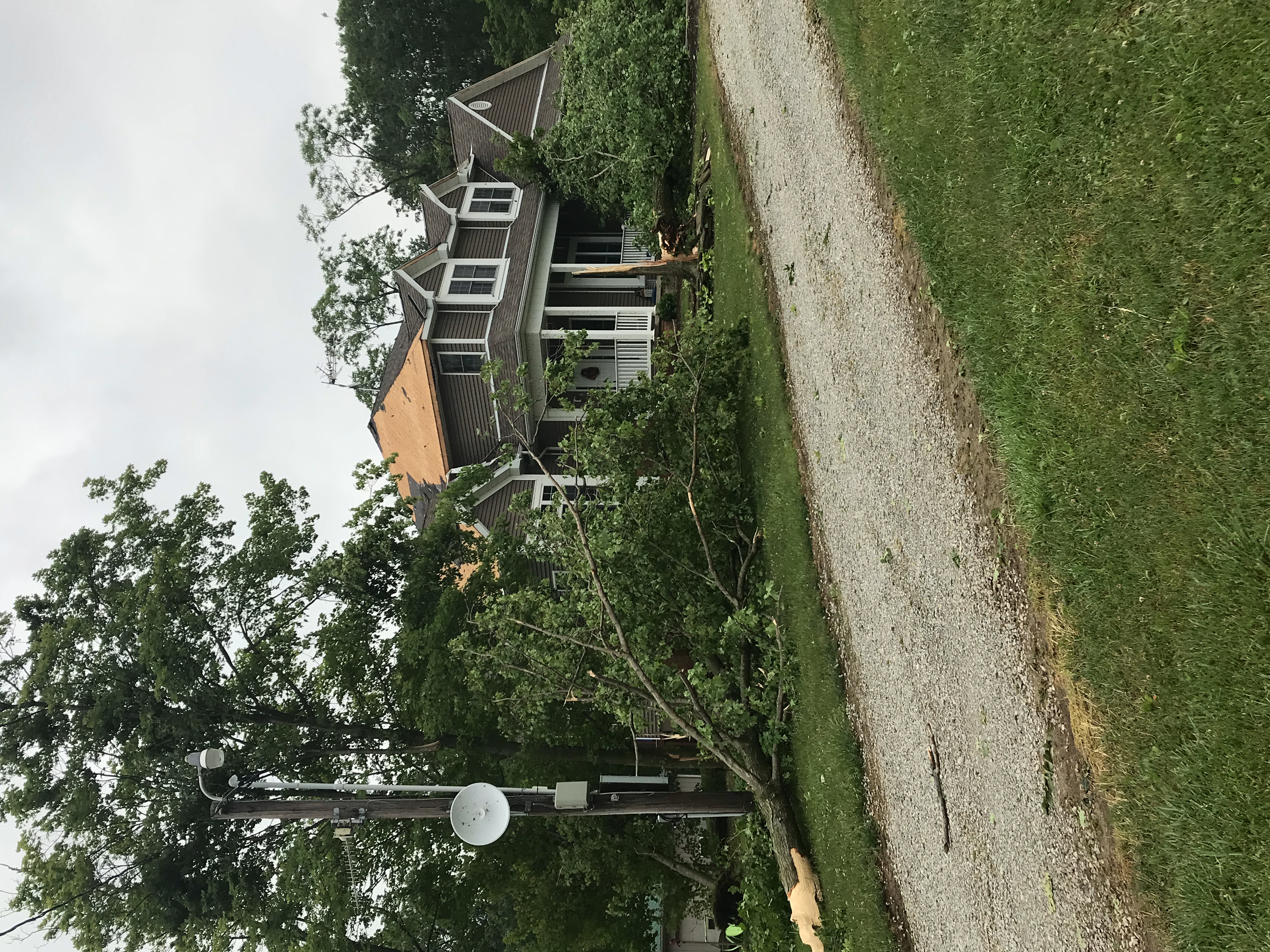
Maumee Bay State Park Tornado
 |
 |
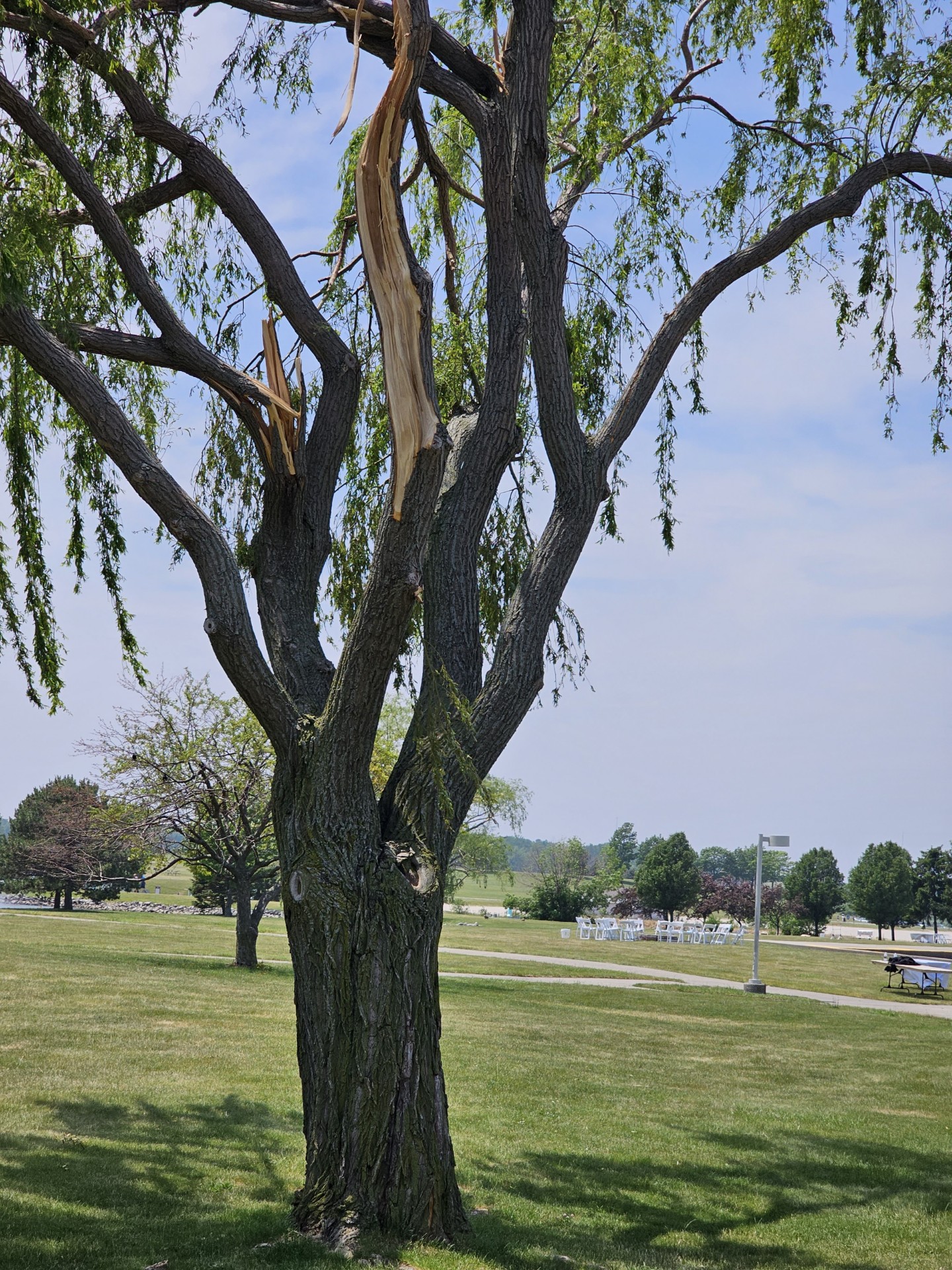
| Damage to a tree in Maumee Bay State Park. (NWS Survey) |
Damage to a tree in Maumee Bay State Park. (NWS Survey) |
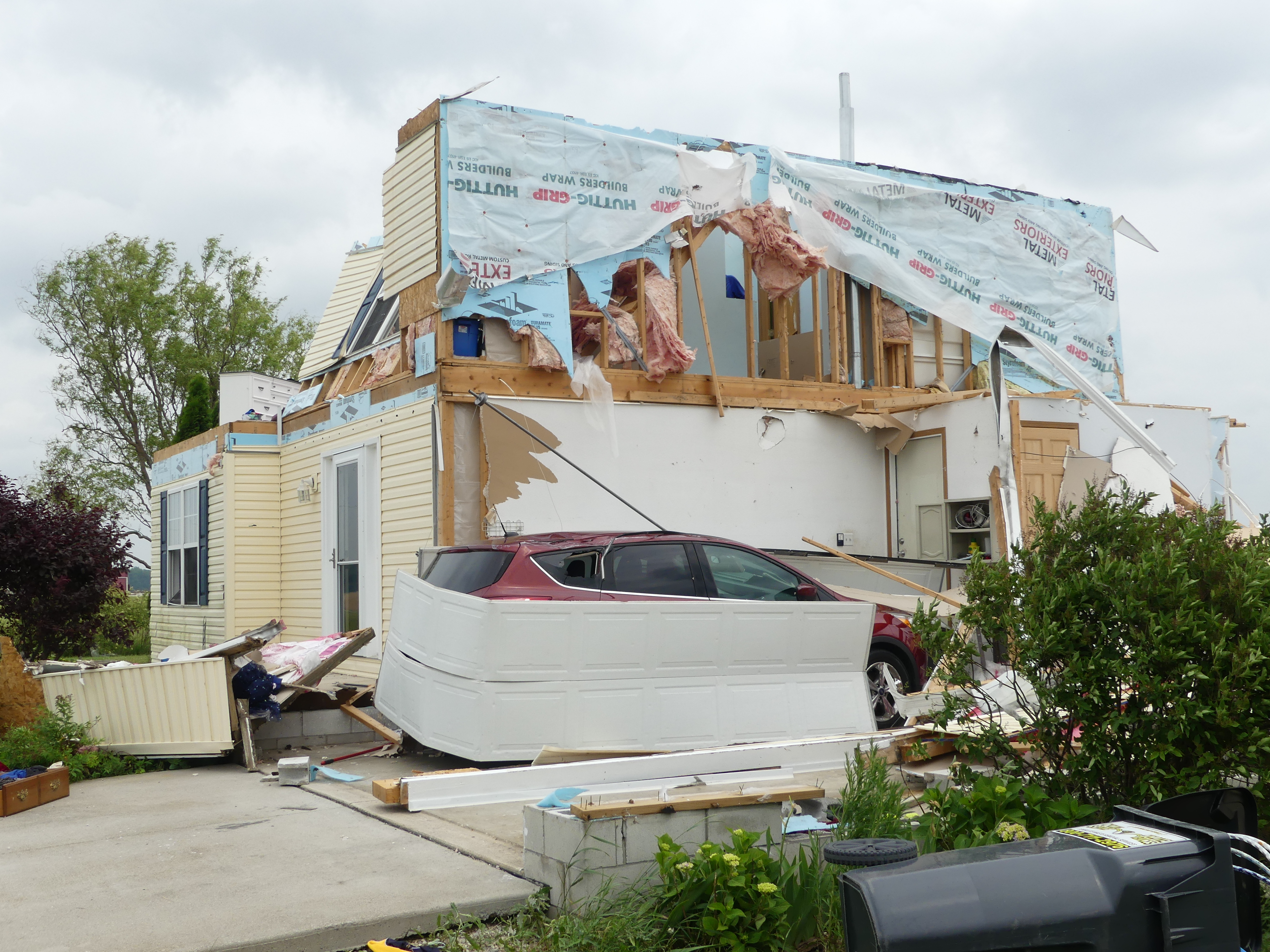
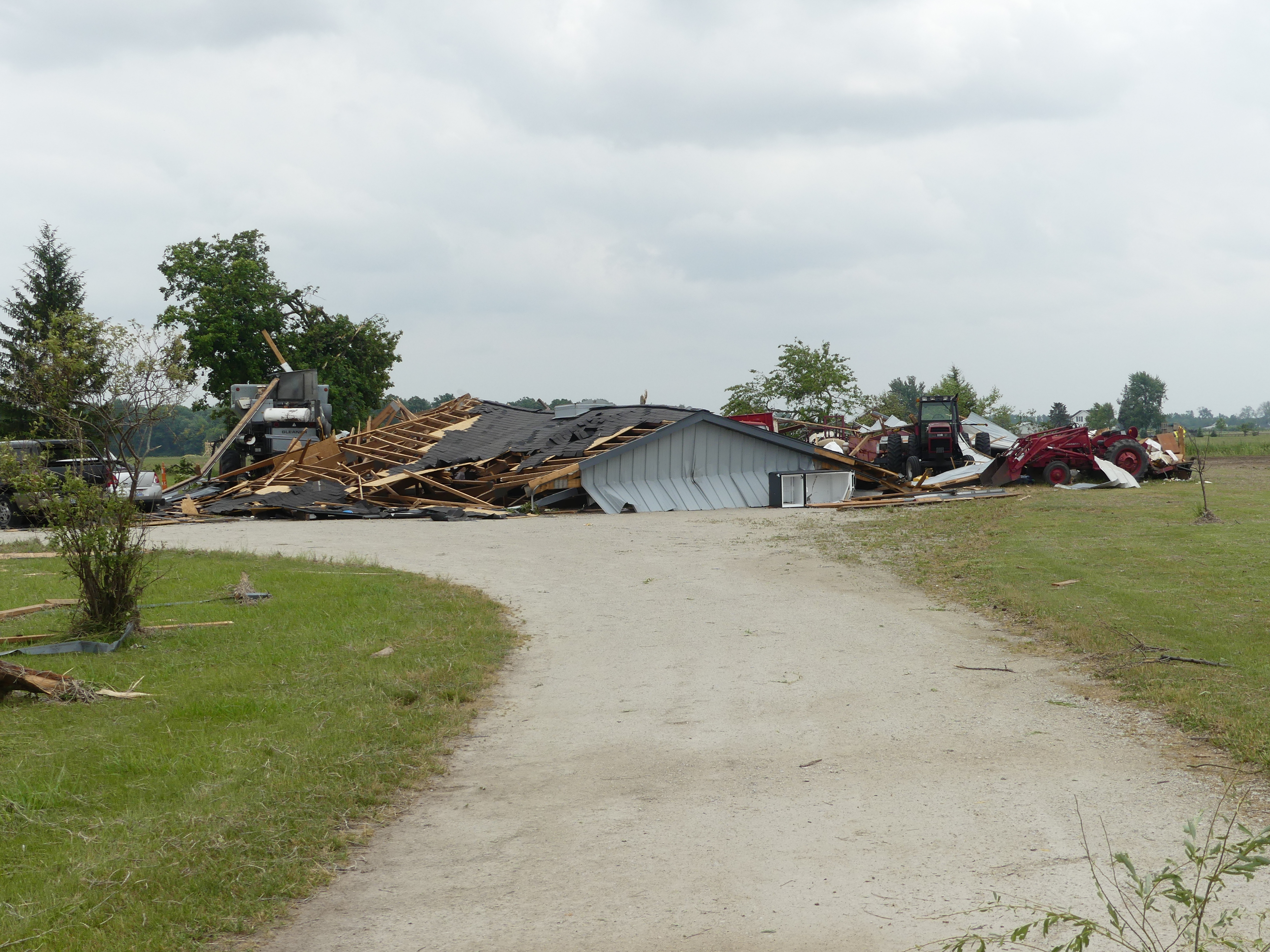
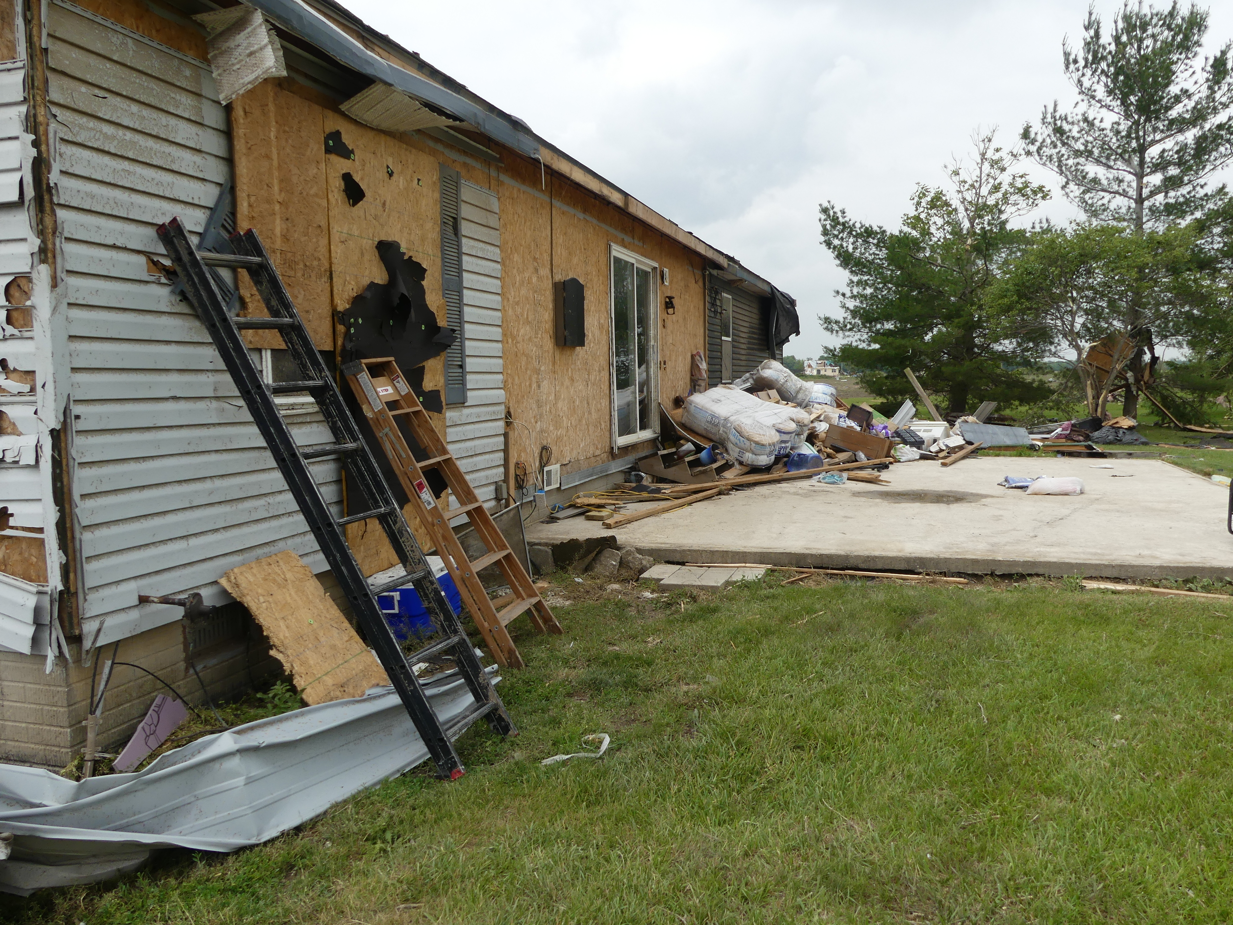
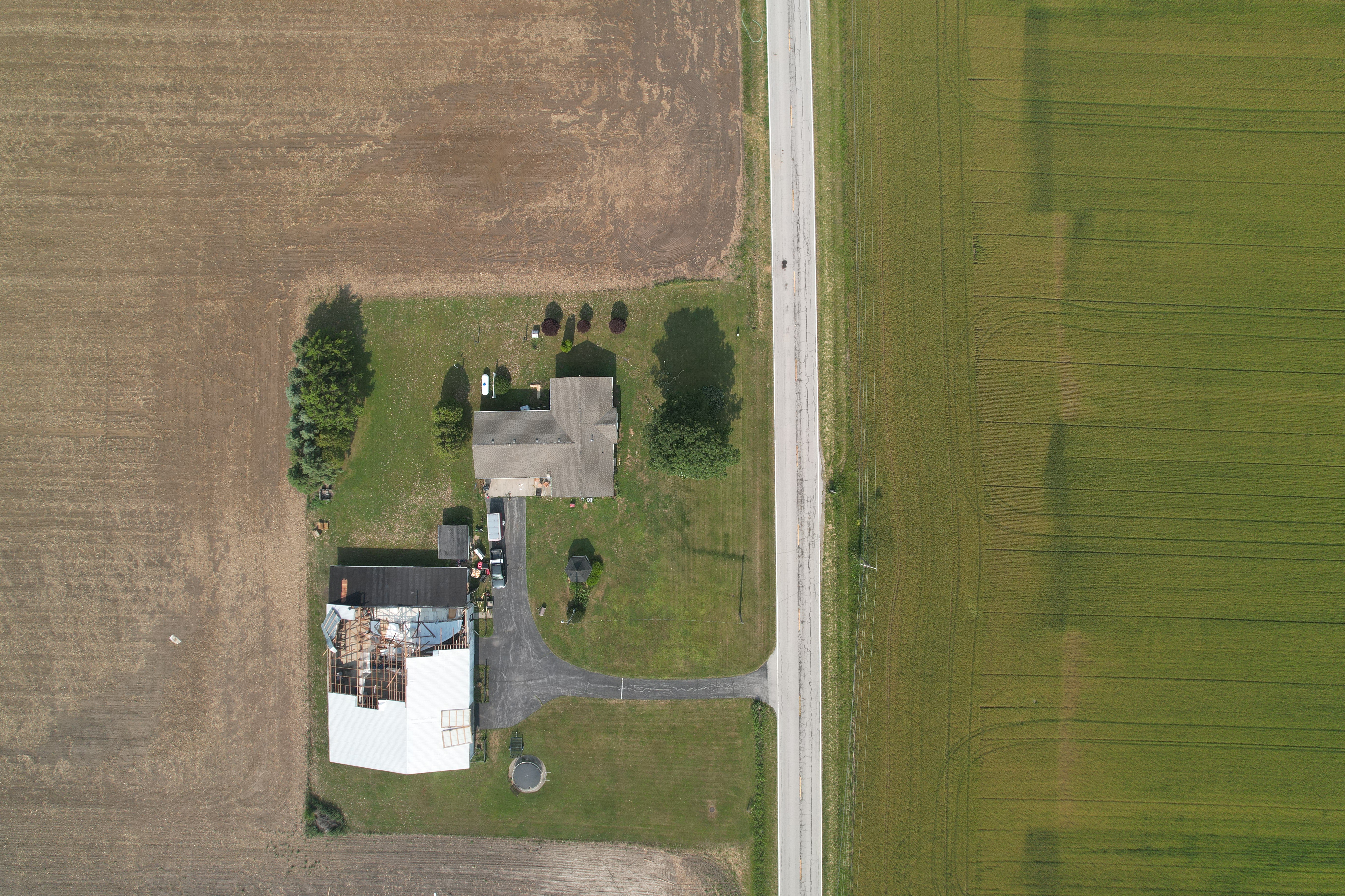
Oak Harbor Tornado
 |
 |
 |
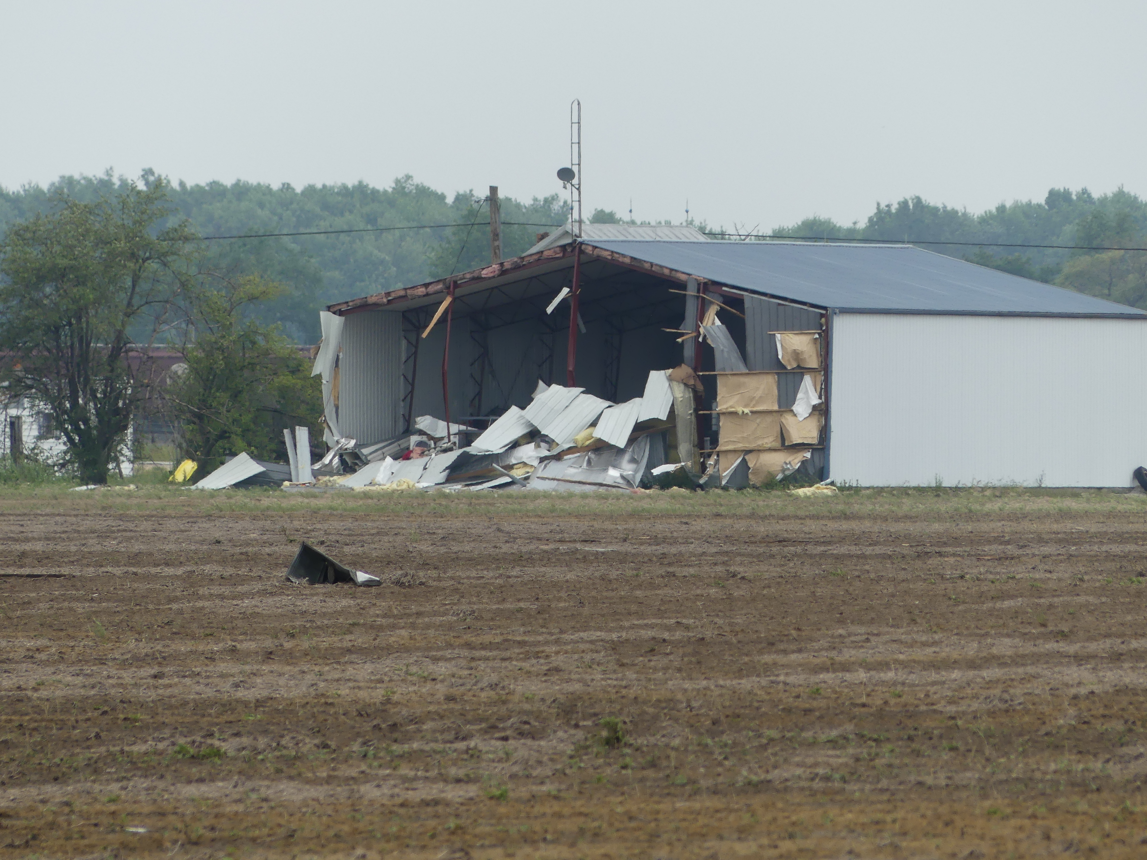 |
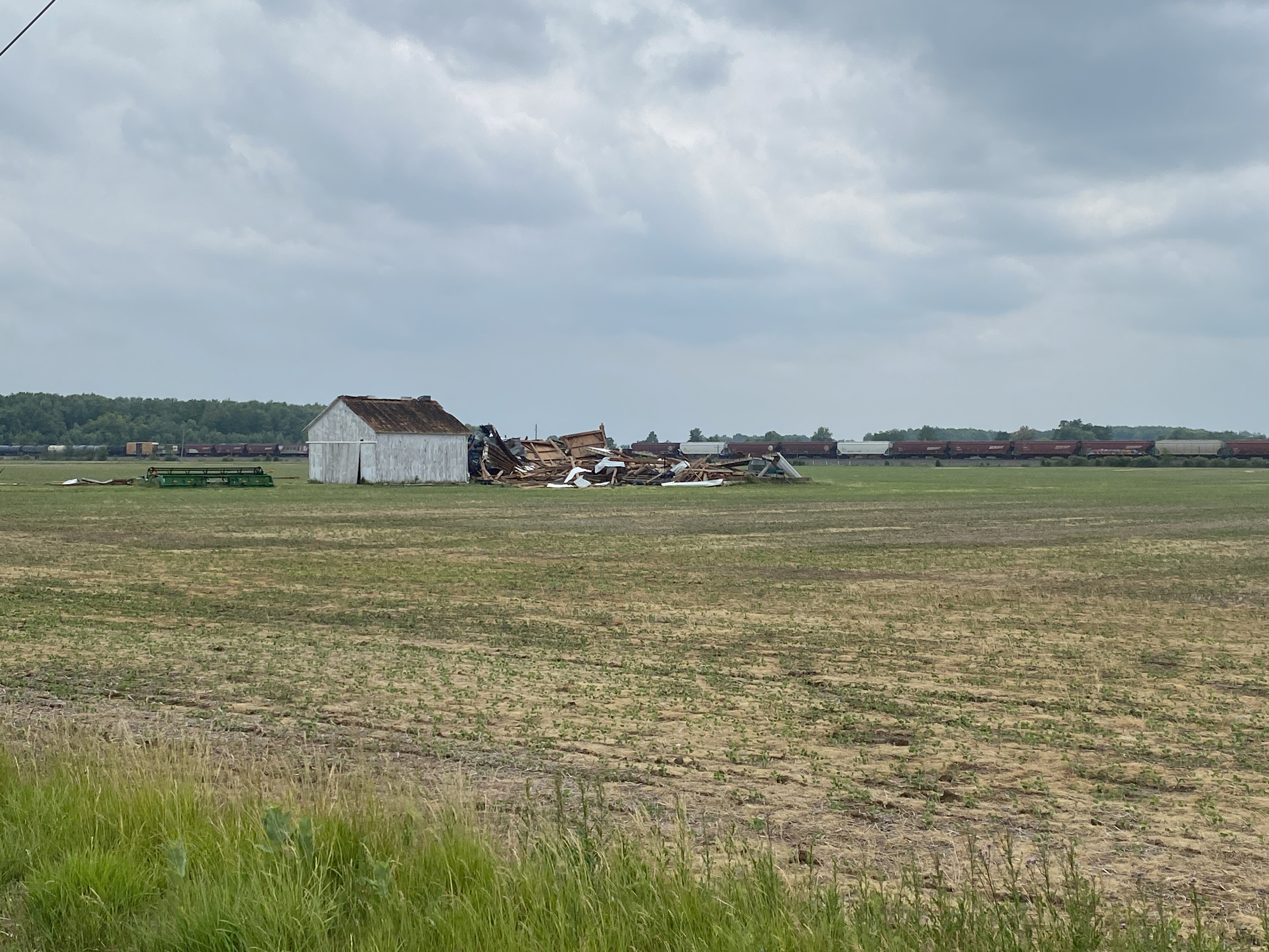
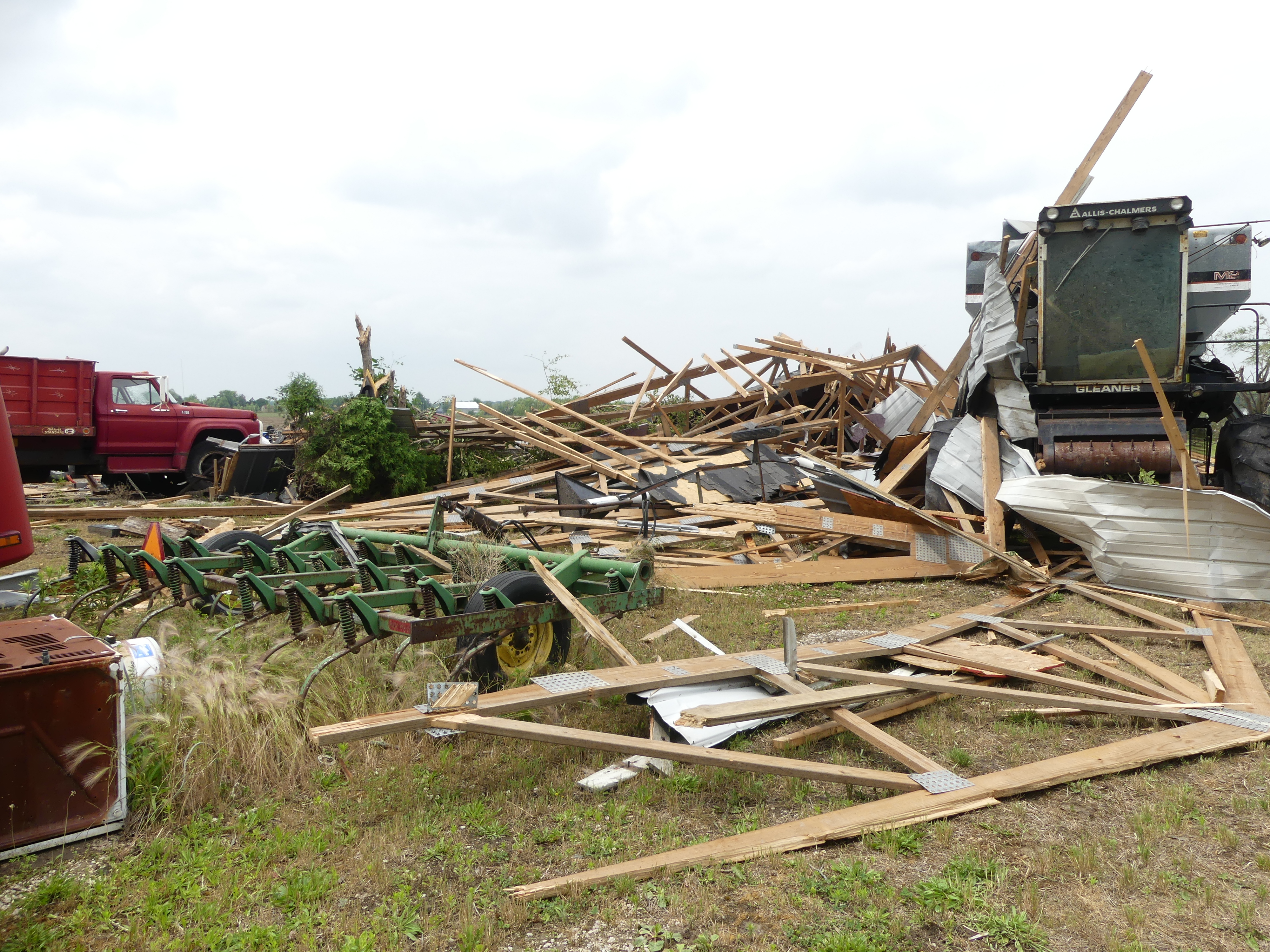
| Farm building completely collapsed. (NWS Survey) |
Complete destruction of an outbuilding that housed farm equipment. (NWS Survey) |
Damage to a house, including portions of the siding, windows, and roof. (NWS Survey) |
Back of an outbuilding completely blown out by tornado. (NWS Survey) |
 |
 |
 |
 |
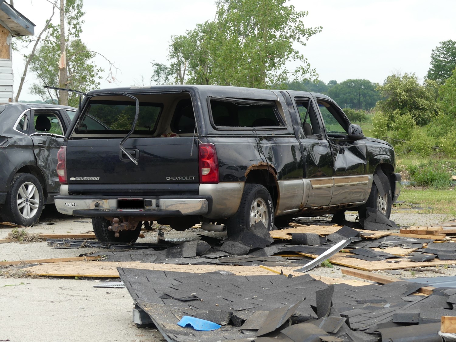
| Significant damage to a vehicle from flying debris. (NWS Survey) |
Debris litters a field under where tree tops were snapped off. (NWS Survey) |
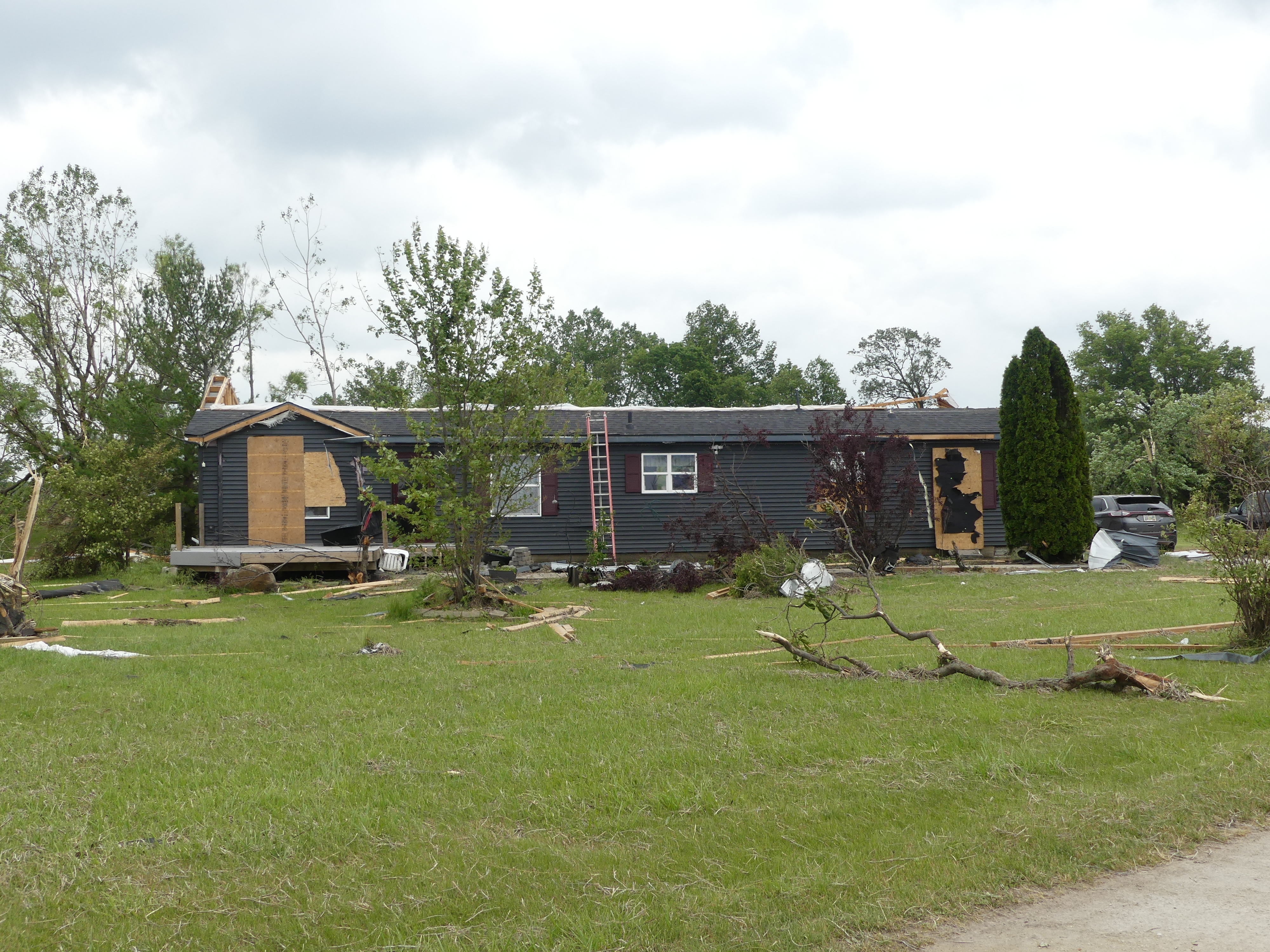
Extensive damage a house, with the second story completely exposed. (NWS Survey) |
Significant damage to the roof of a house, along with siding damage. (NWS Survey) |
 |
 |
 |
 |
| Outbuilding completely destroyed. (NWS Survey) |
Damage to the roof and siding of a house. Debris from the storm also lays in the front yard. (NWS Survey) |
Siding ripped from a house. (NWS Survey) |
Trees snapped and twisted. (NWS Survey) |
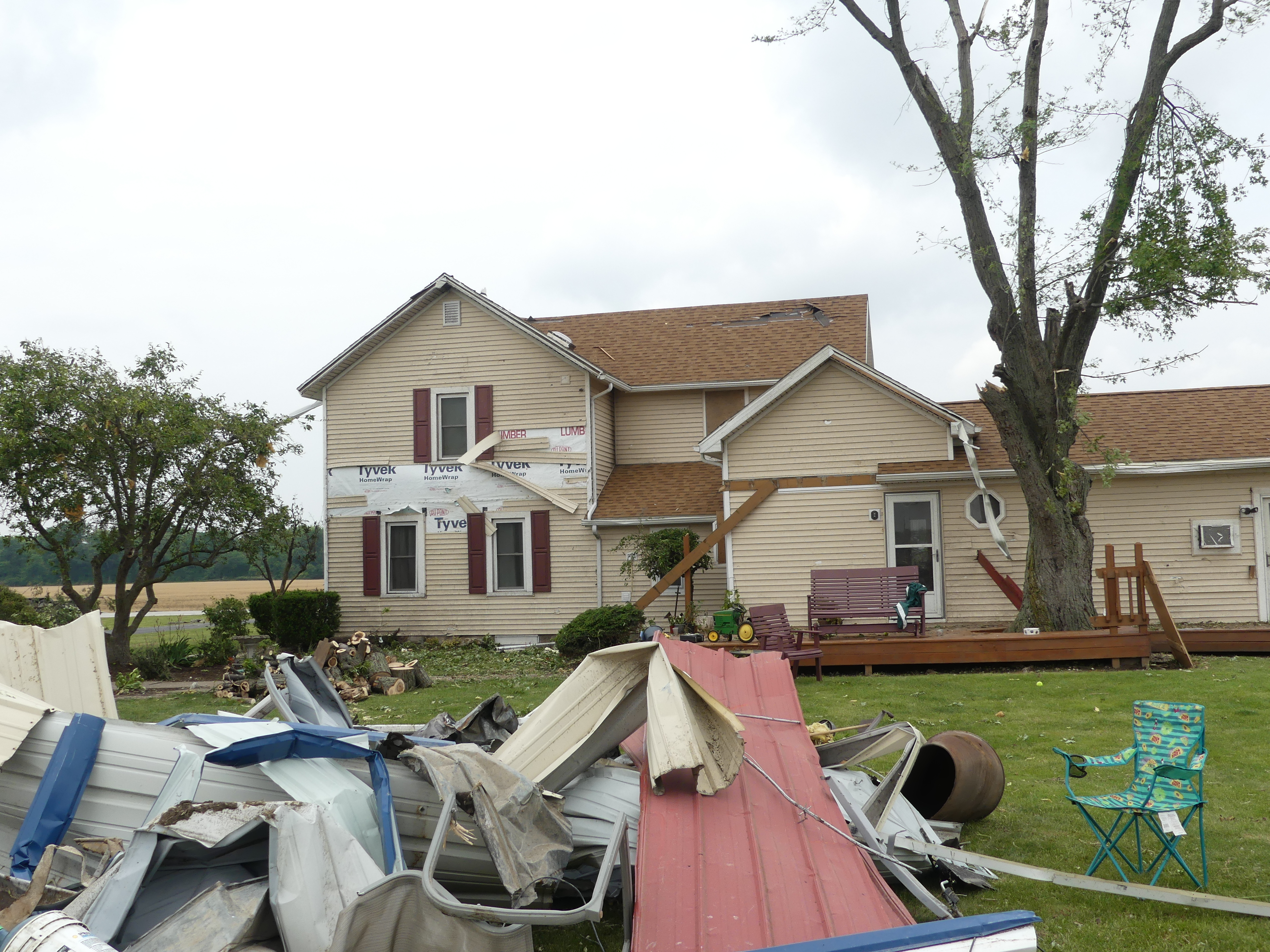
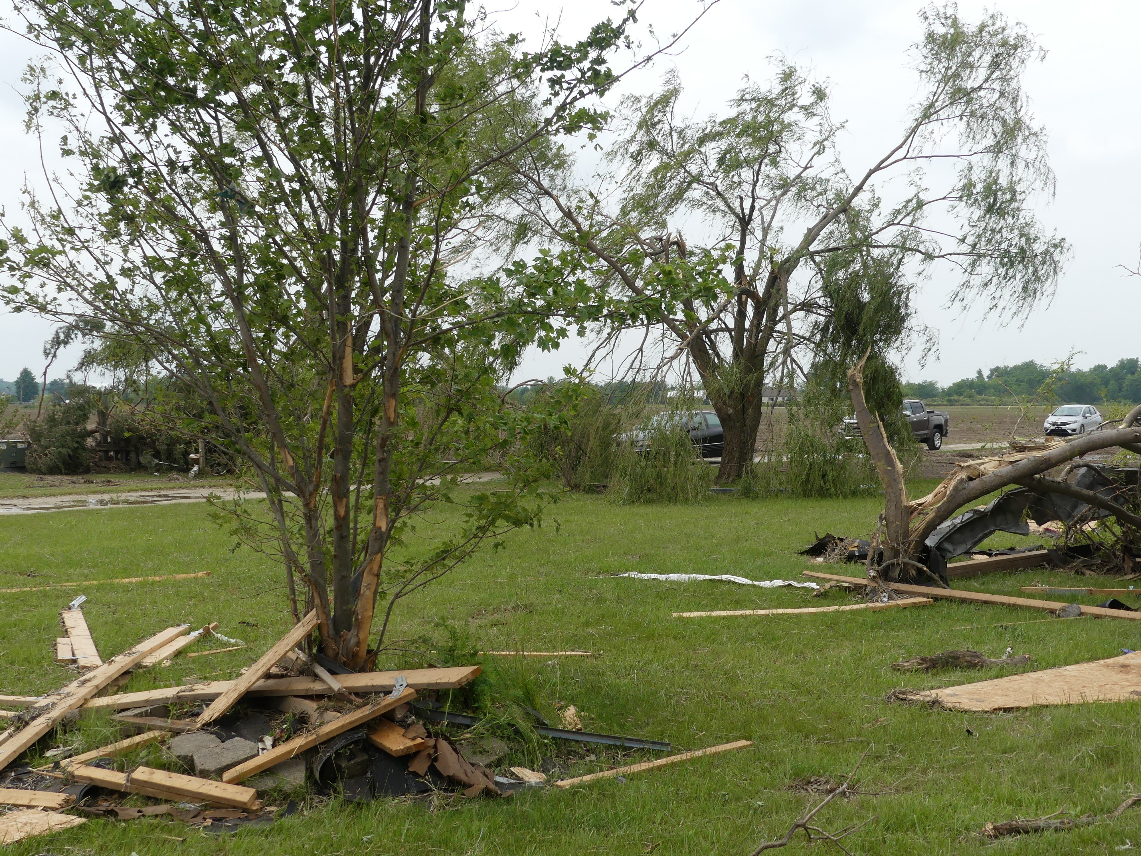
Rice Township Tornado
 |
 |
 |
 |
| Damage to a home in Rice Township. (NWS Survey) |
Large uprooted tree that fell on part of a home. (NWS Survey) |
Damage to a roof where flying debris created a gap. (NWS Survey) |
Multiple trees uprooted on a property in Rice Township. (NWS Survey) |
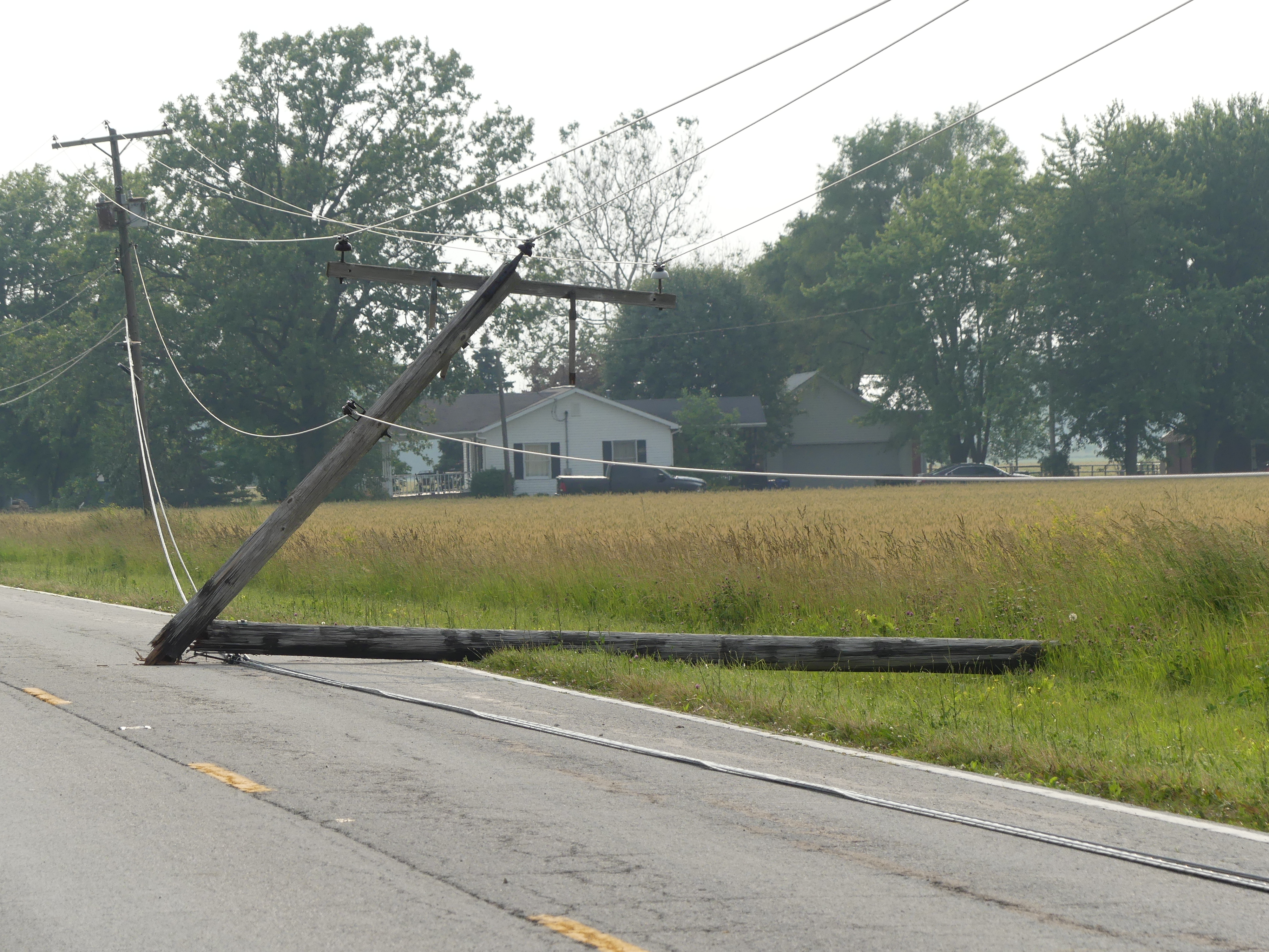
Vickery Tornado
 |
 |
 |
 |
| Starting location of the Vickery tornado where there was damage to an outbuilding. (Owen Fritz) |
Damage to an outbuilding. (NWS Survey) |
Power poles snapped along Whitmore Road. (NWS Survey) |
Shingles and other debris was scattered across the area. (NWS Survey) |
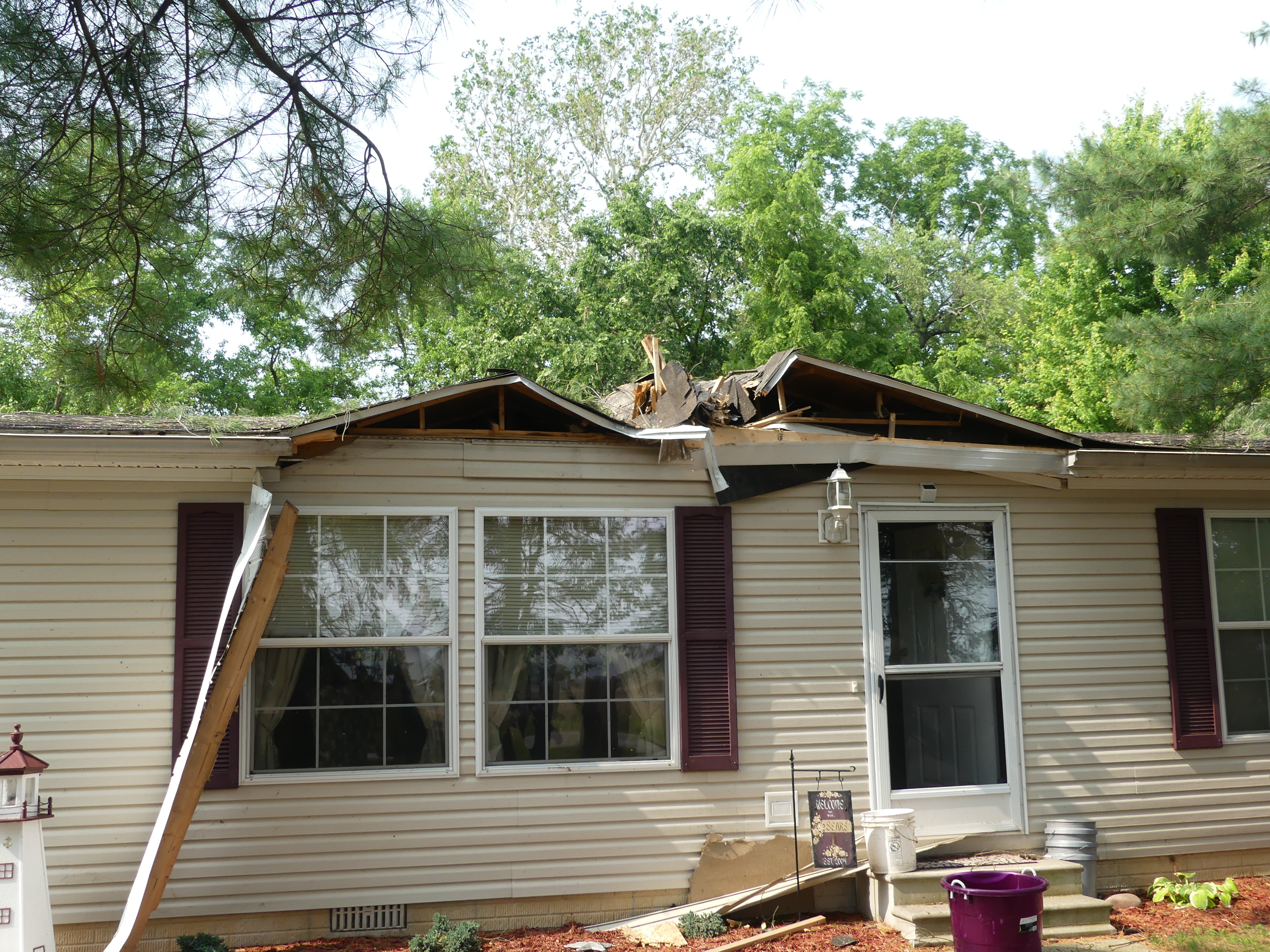
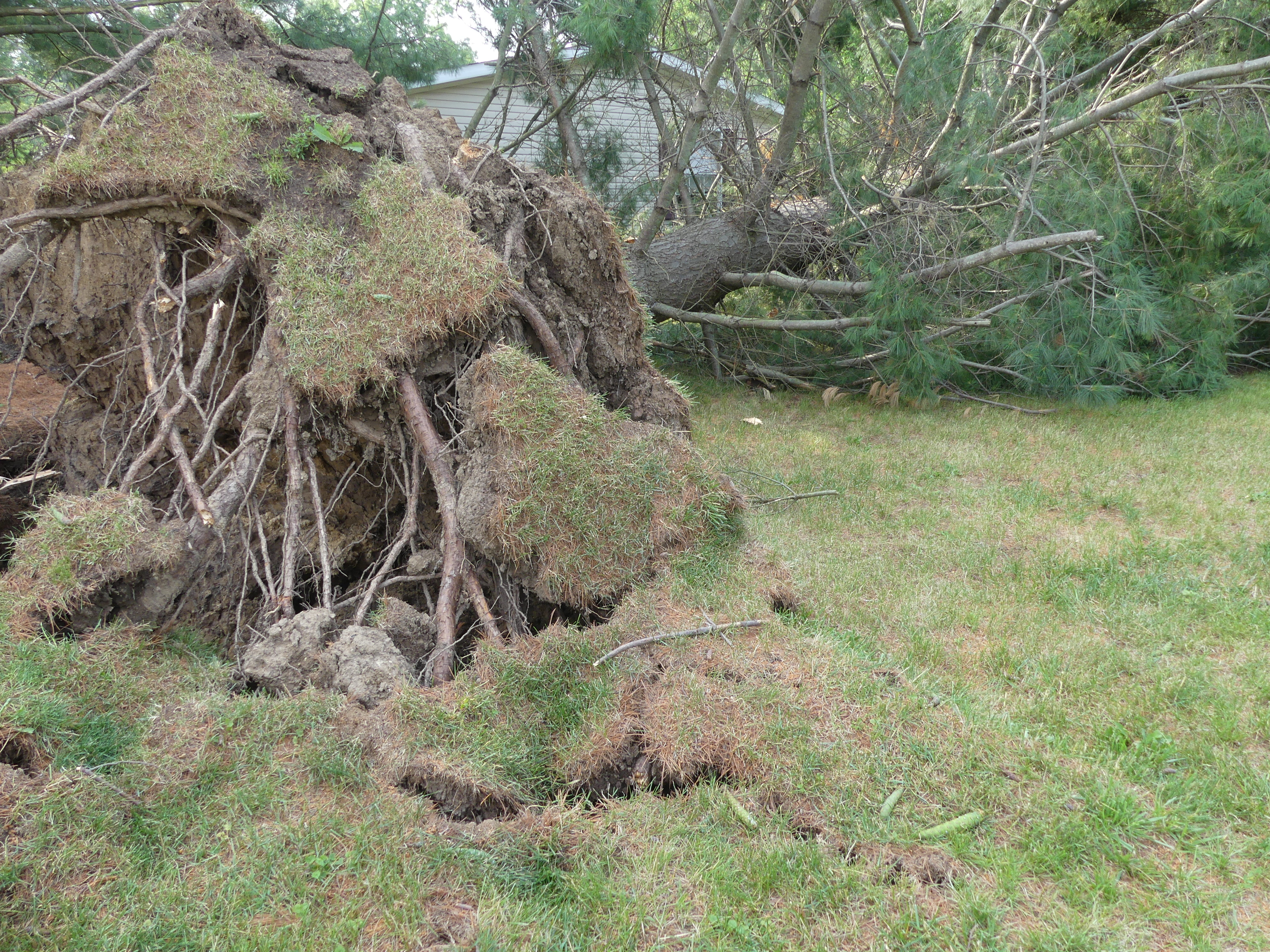
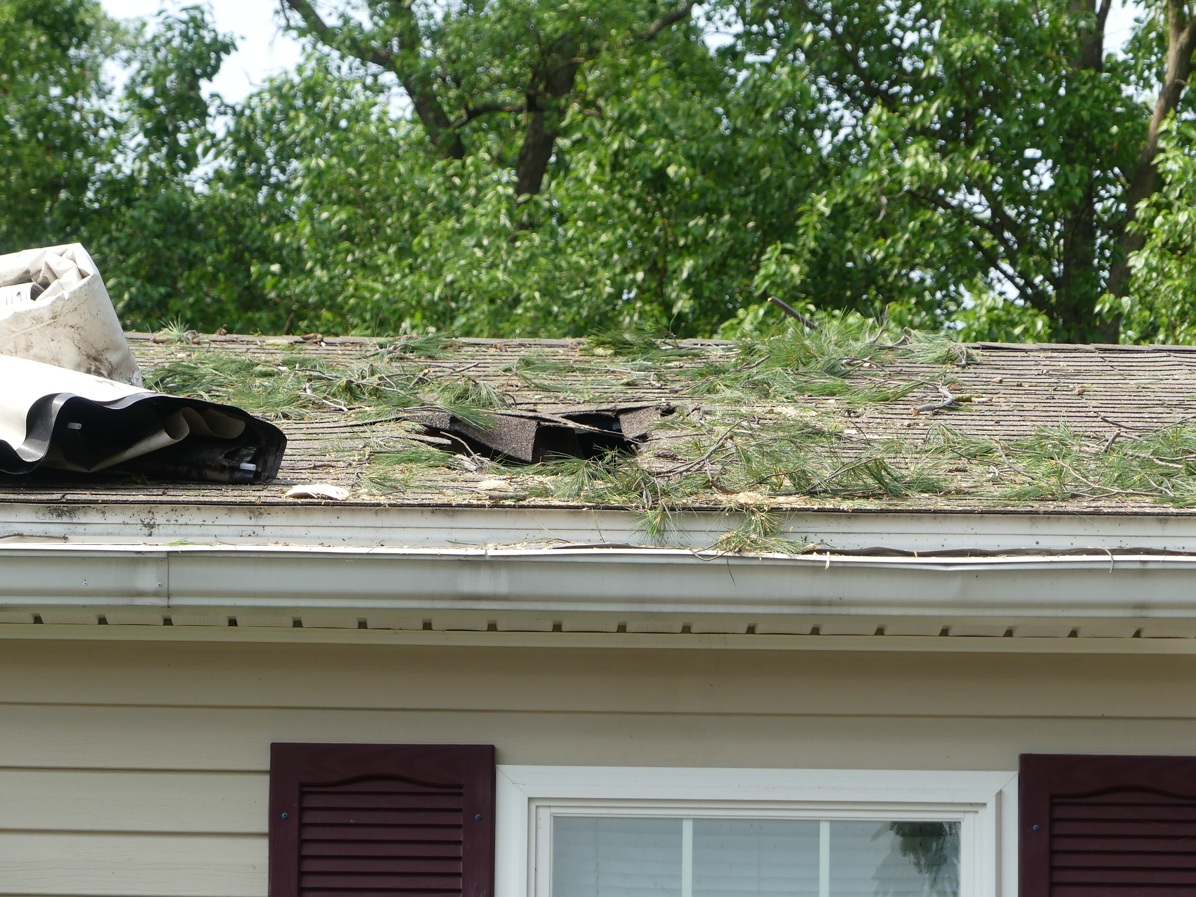
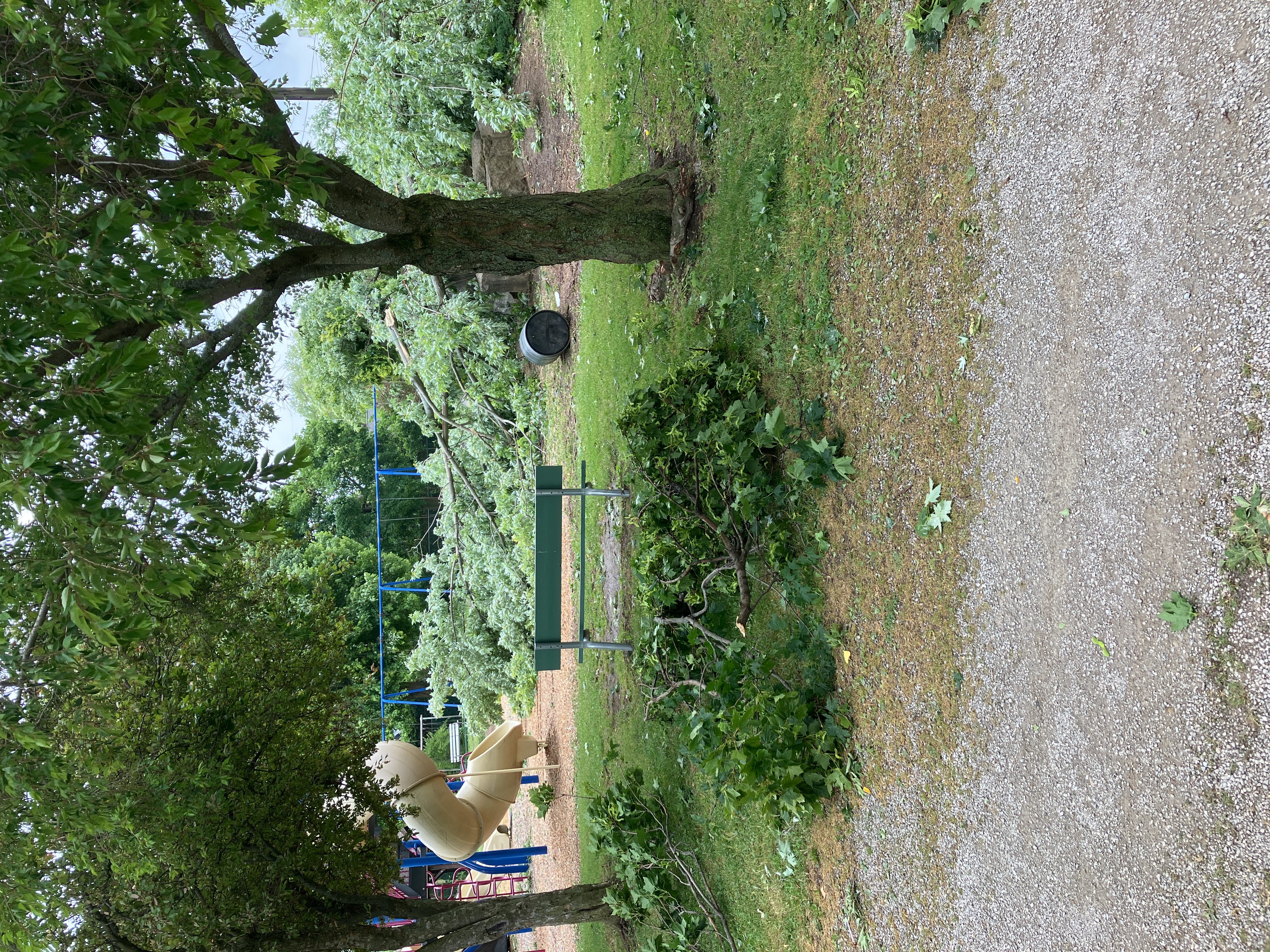
Bellevue Tornado
 |
 |
 |
 |
| Tops of trees snapped off. (NWS Survey) |
Uprooted tree fell on part of a house. (NWS Survey) |
Numerous large, snapped tree branches littered a playground. (NWS Survey) |
Large limb of tree snapped off. (NWS Survey) |
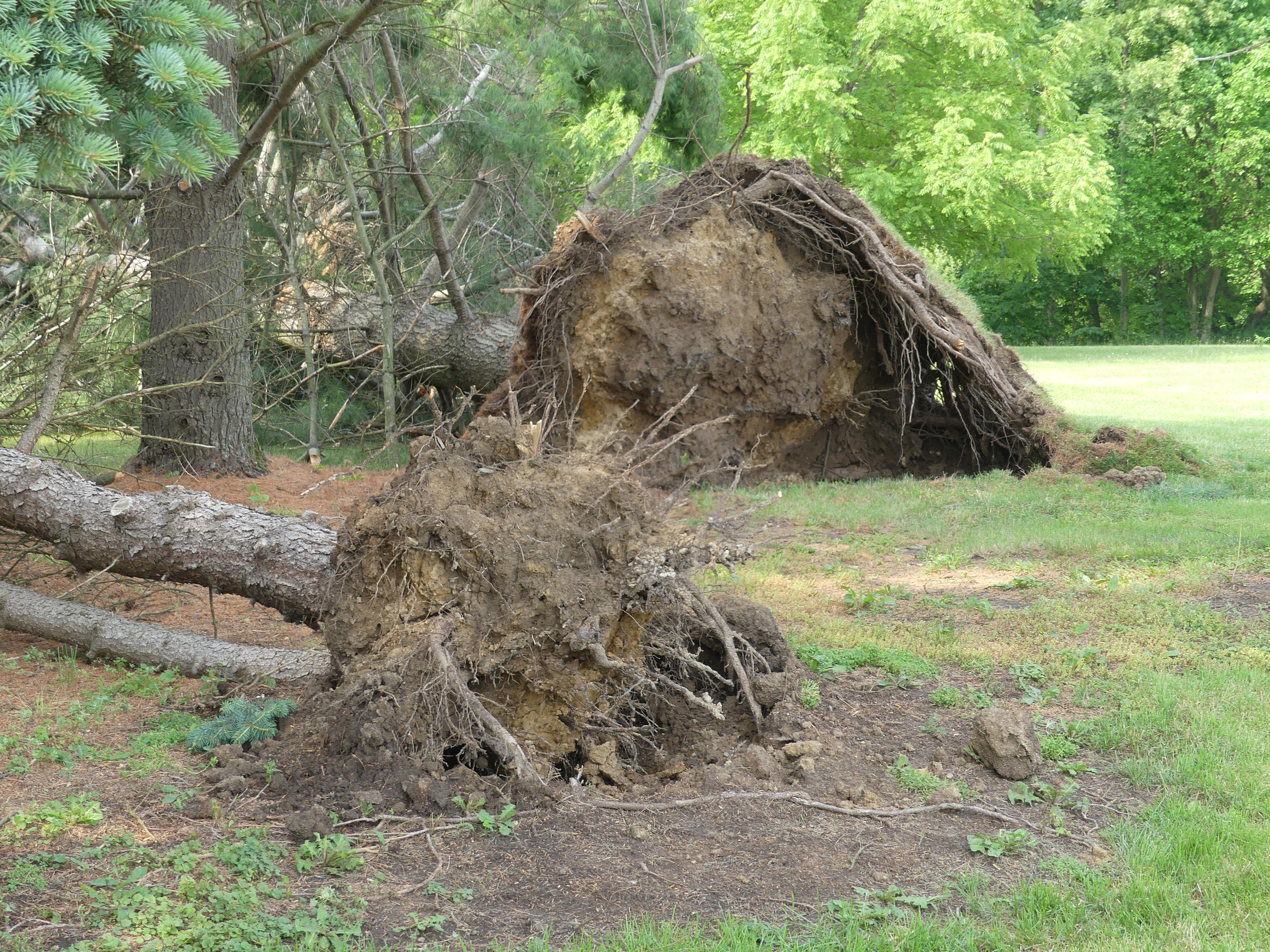
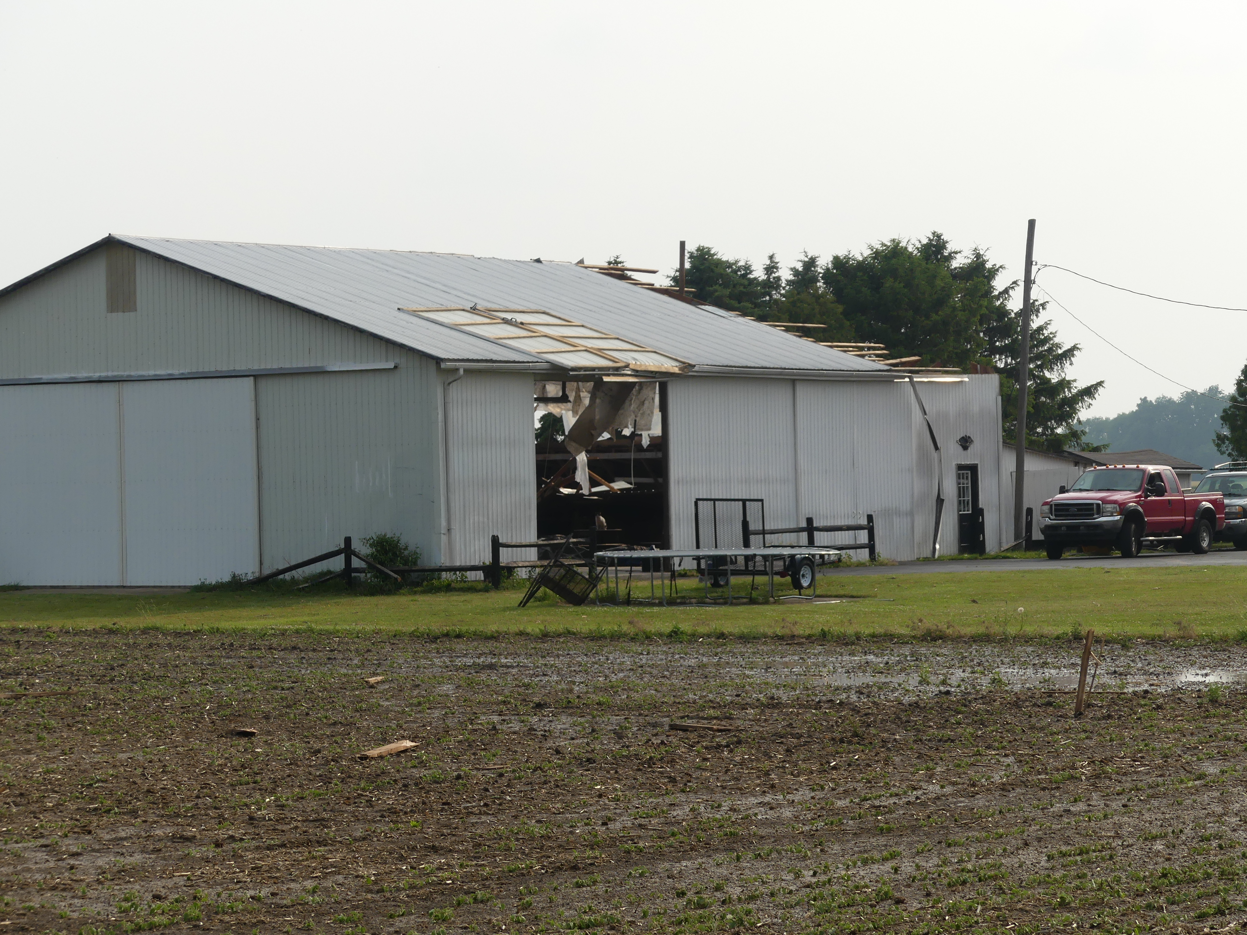
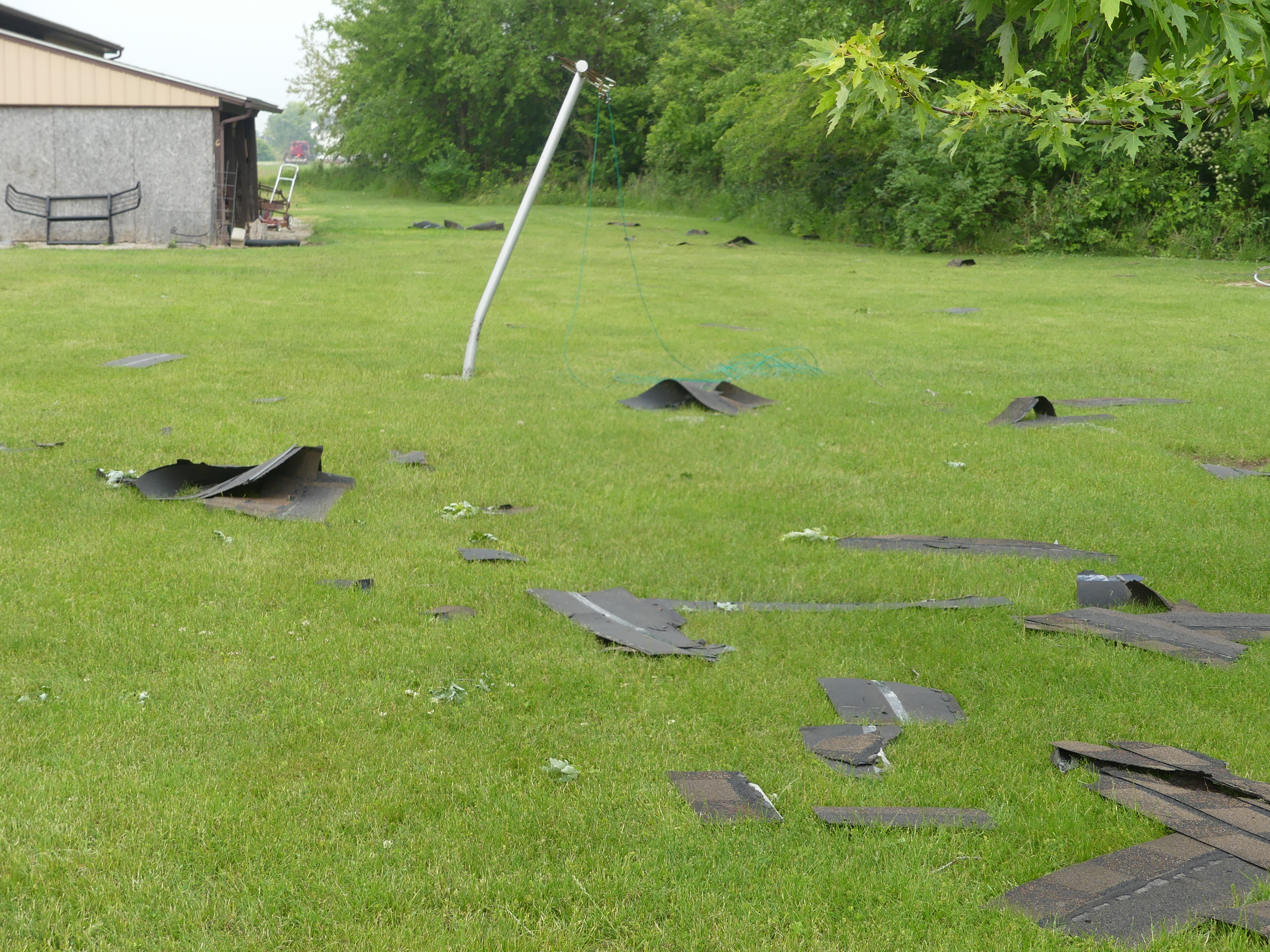
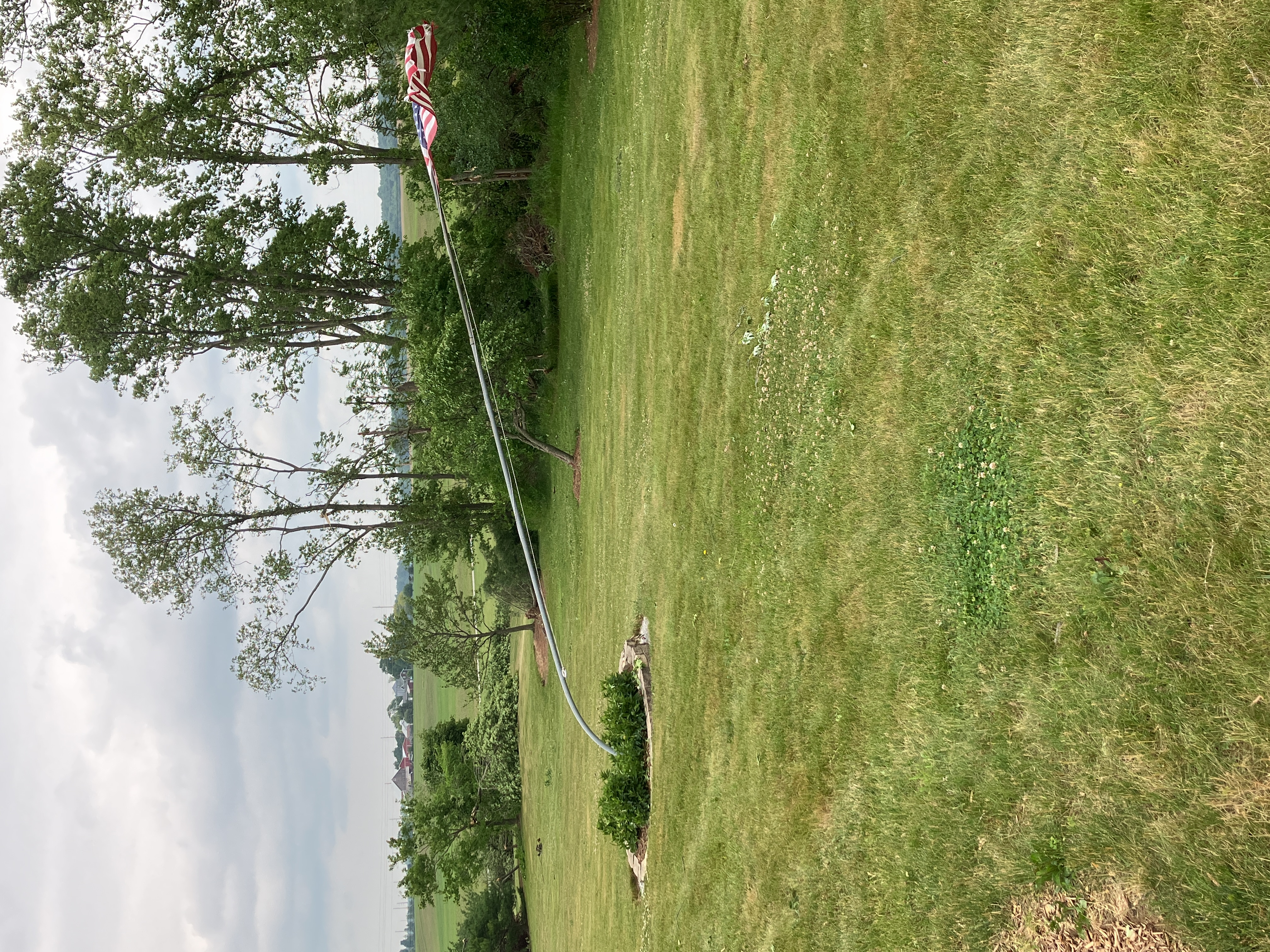
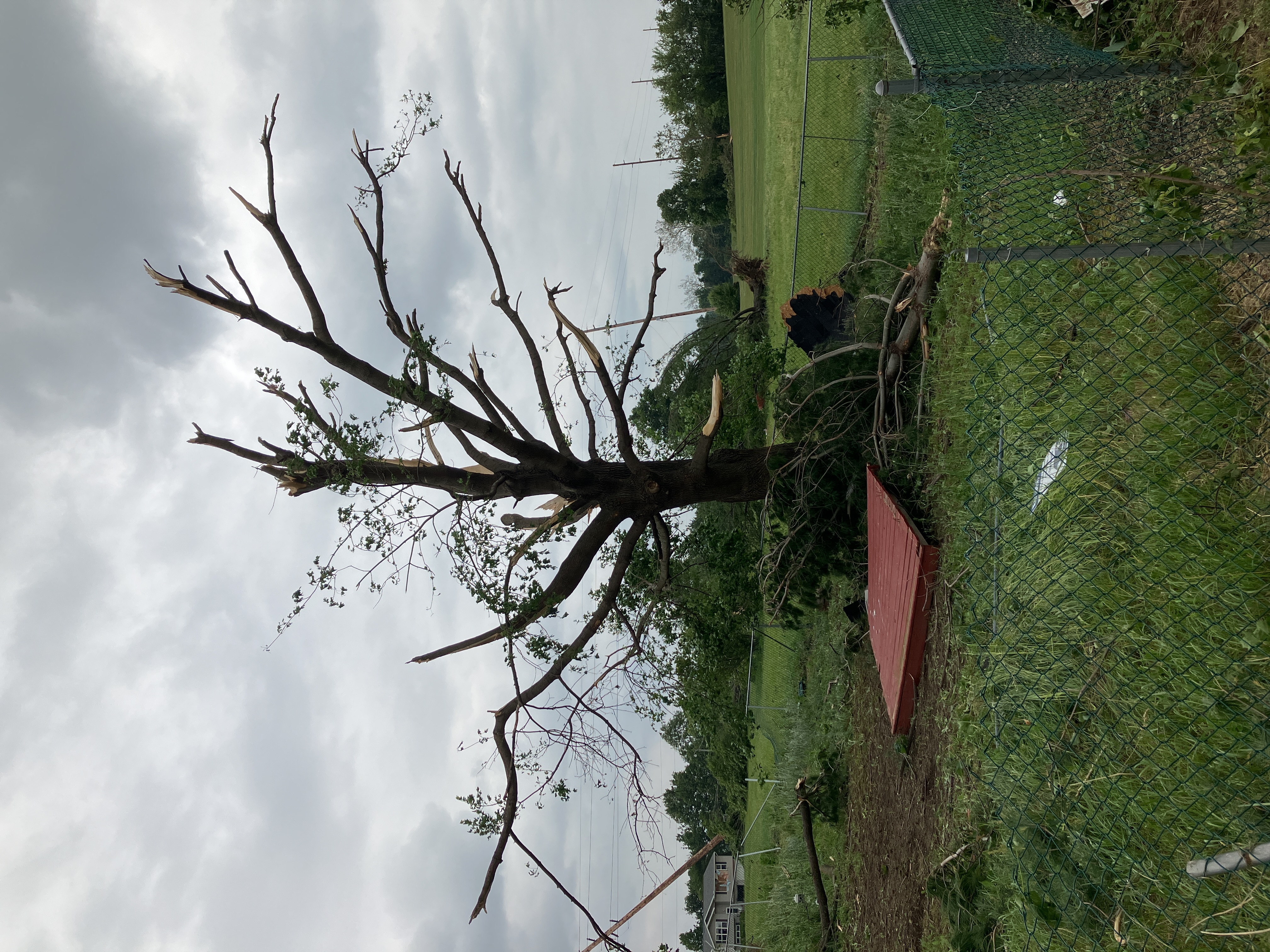
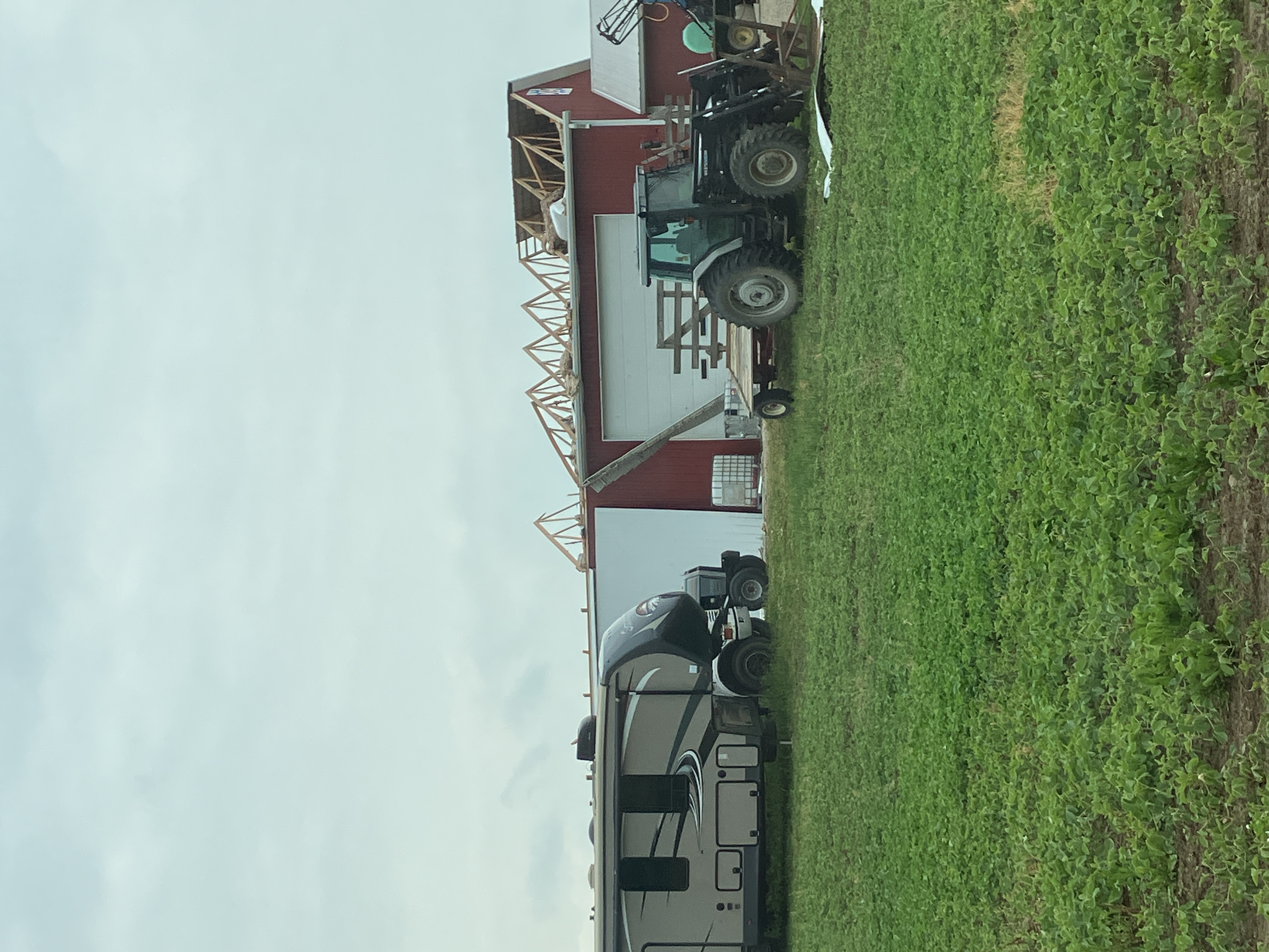
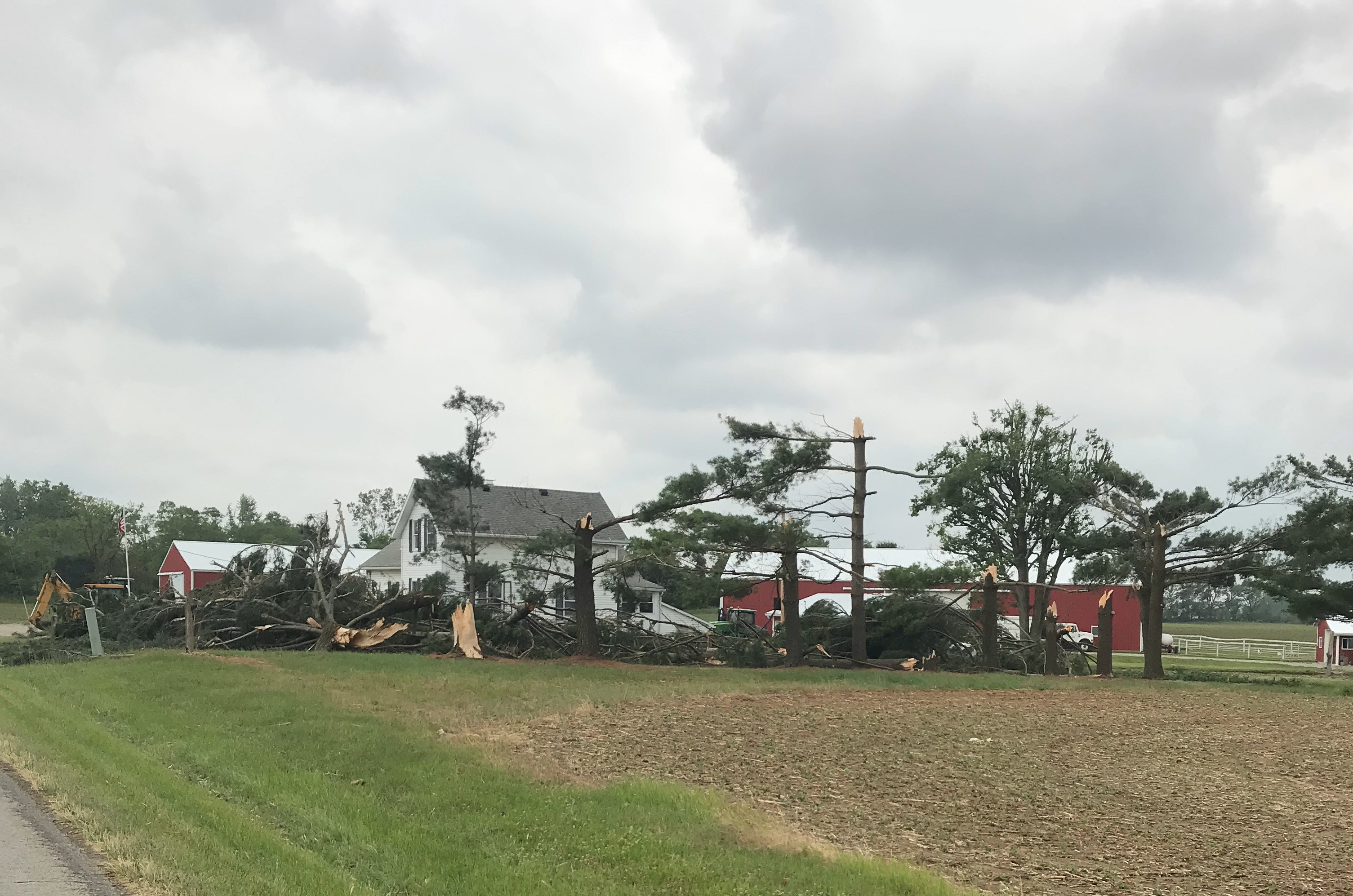
Peru Township Tornado
 |
 |
 |
 |
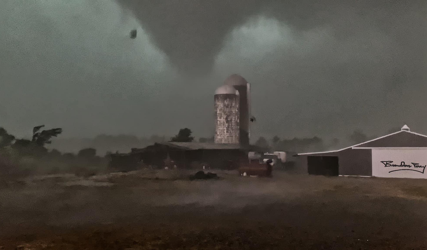
| Tornado over a farm in Peru. (Justin & Brandon Perry) |
Barn partially collapsed (NWS Survey) |
Outbuilding destroyed (NWS Survey) |
Bent flag pole (NWS Survey) |
 |
 |
 |
 |
| Most larger limbs shredded (NWS Survey) |
Roof of barn blown off (NWS Survey) |
Damaged silo (NWS Survey) |
Roof missing and downed tree (NWS Survey) |
North Fairfield Tornado
 |
 |
 |
 |
| Roof damage to outbuilding (NWS Survey) |
Numerous tree limbs down (NWS Survey) |
Large tree on home (NWS Survey) |
Roof of home damaged (NWS Survey) |
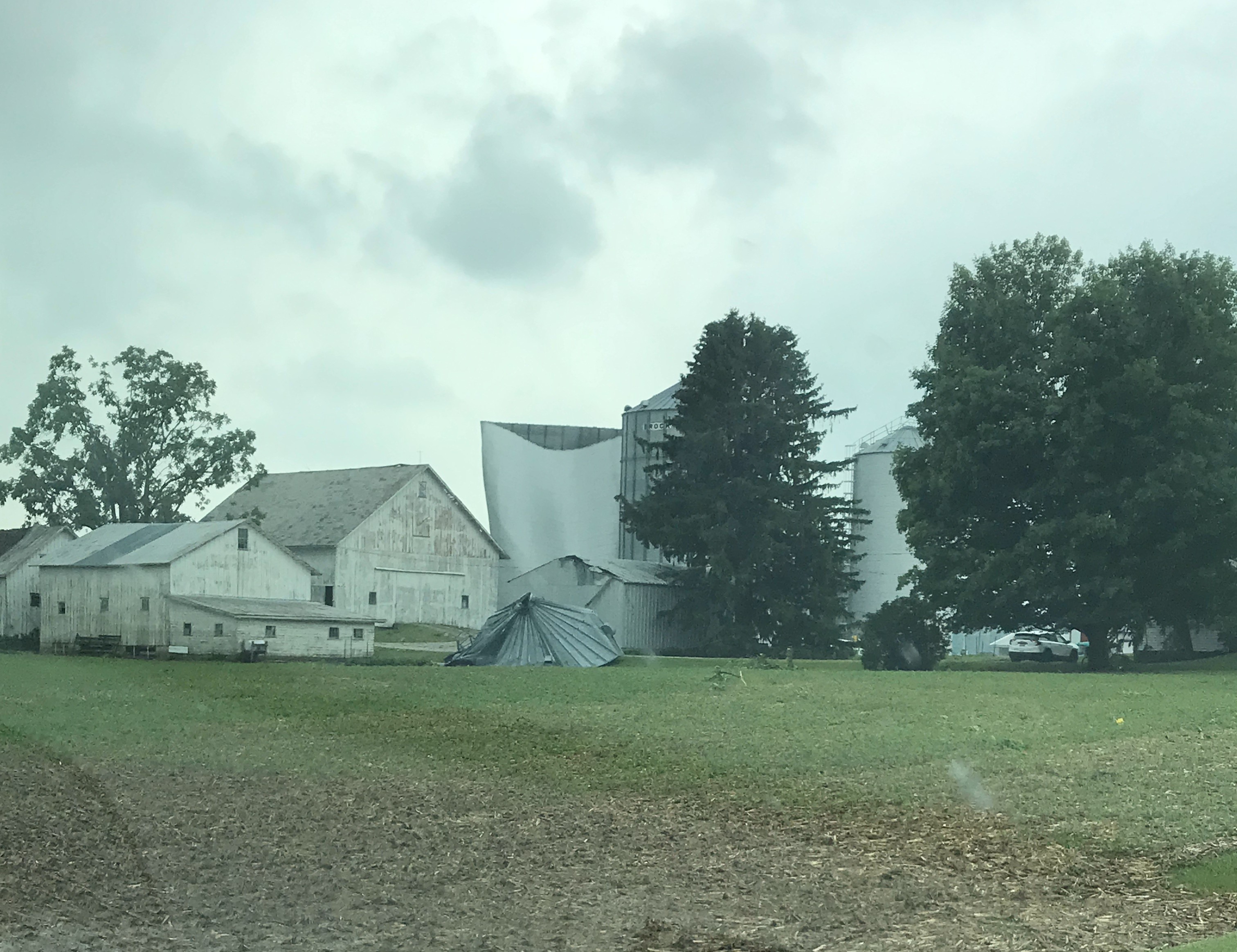
Greenwich Tornado
 |
 |
 |
 |
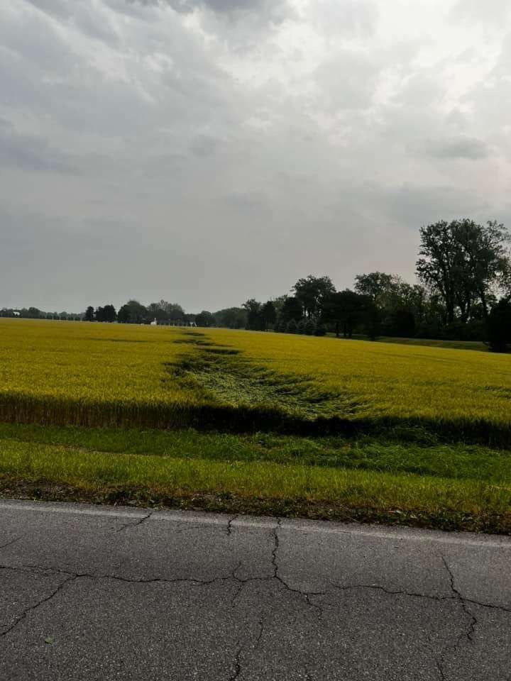
| Swirl in field (NWS Survey) |
Silos blown over (NWS Survey) |
Damaged Pine trees (NWS Survey |
Damaged Silos (NWS Survey) |
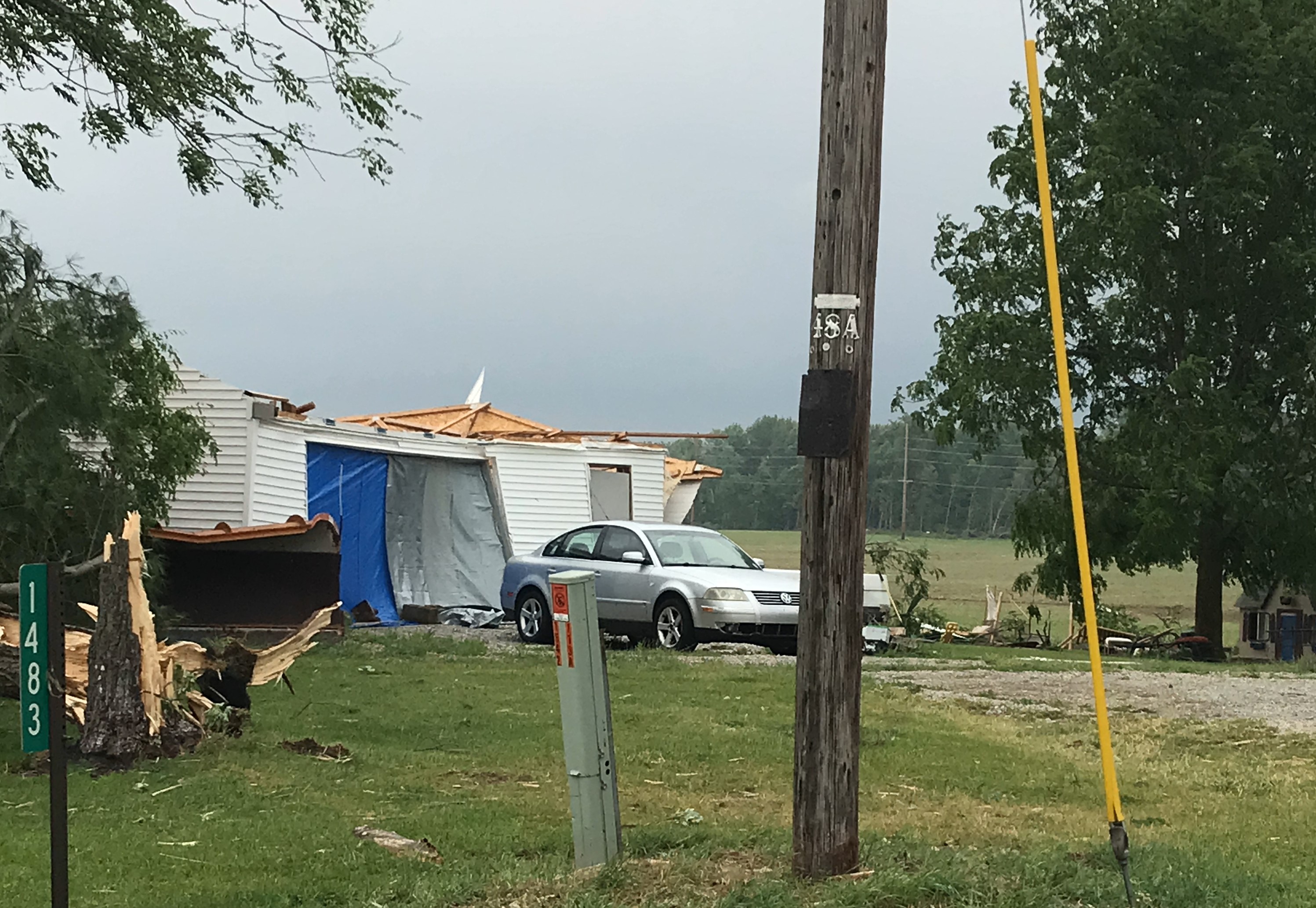
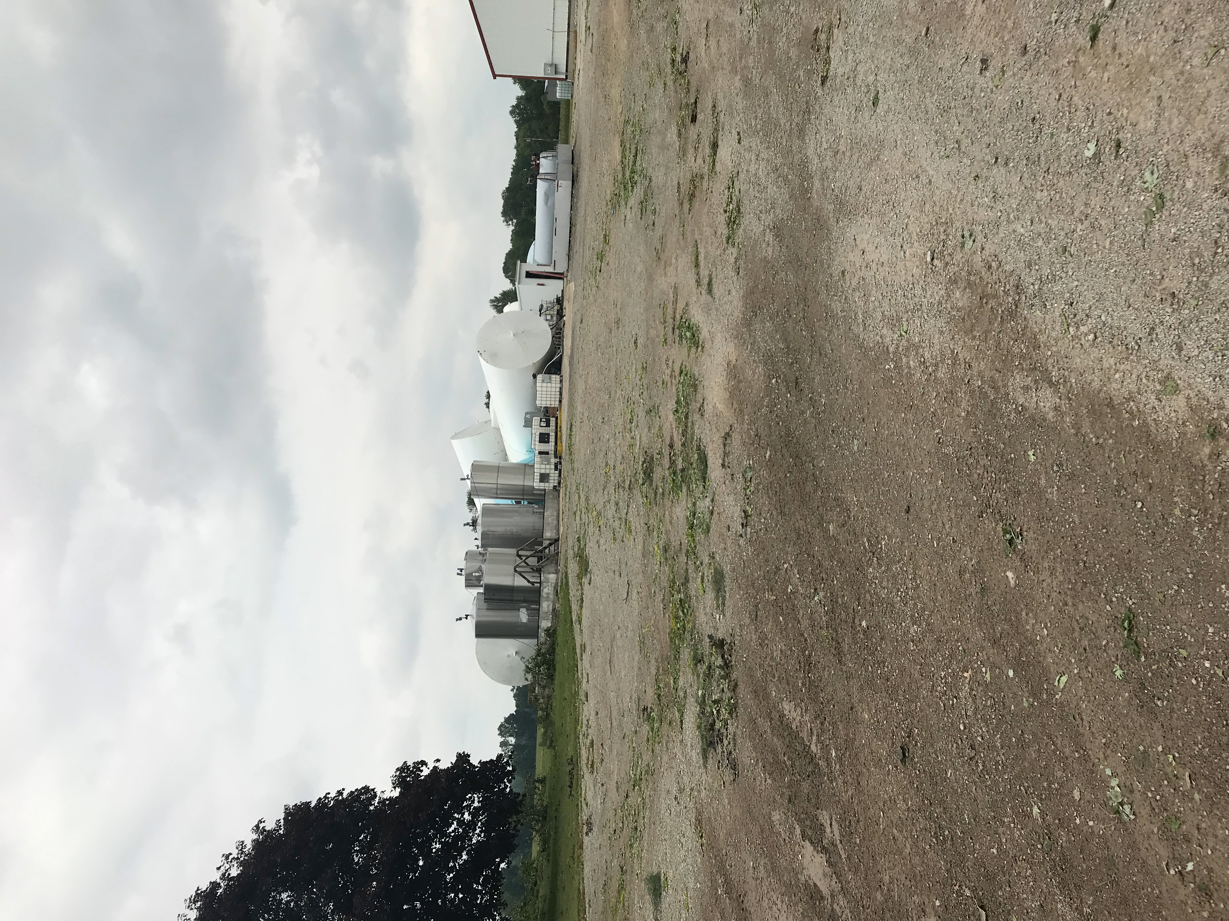
Nankin Tornado
 |
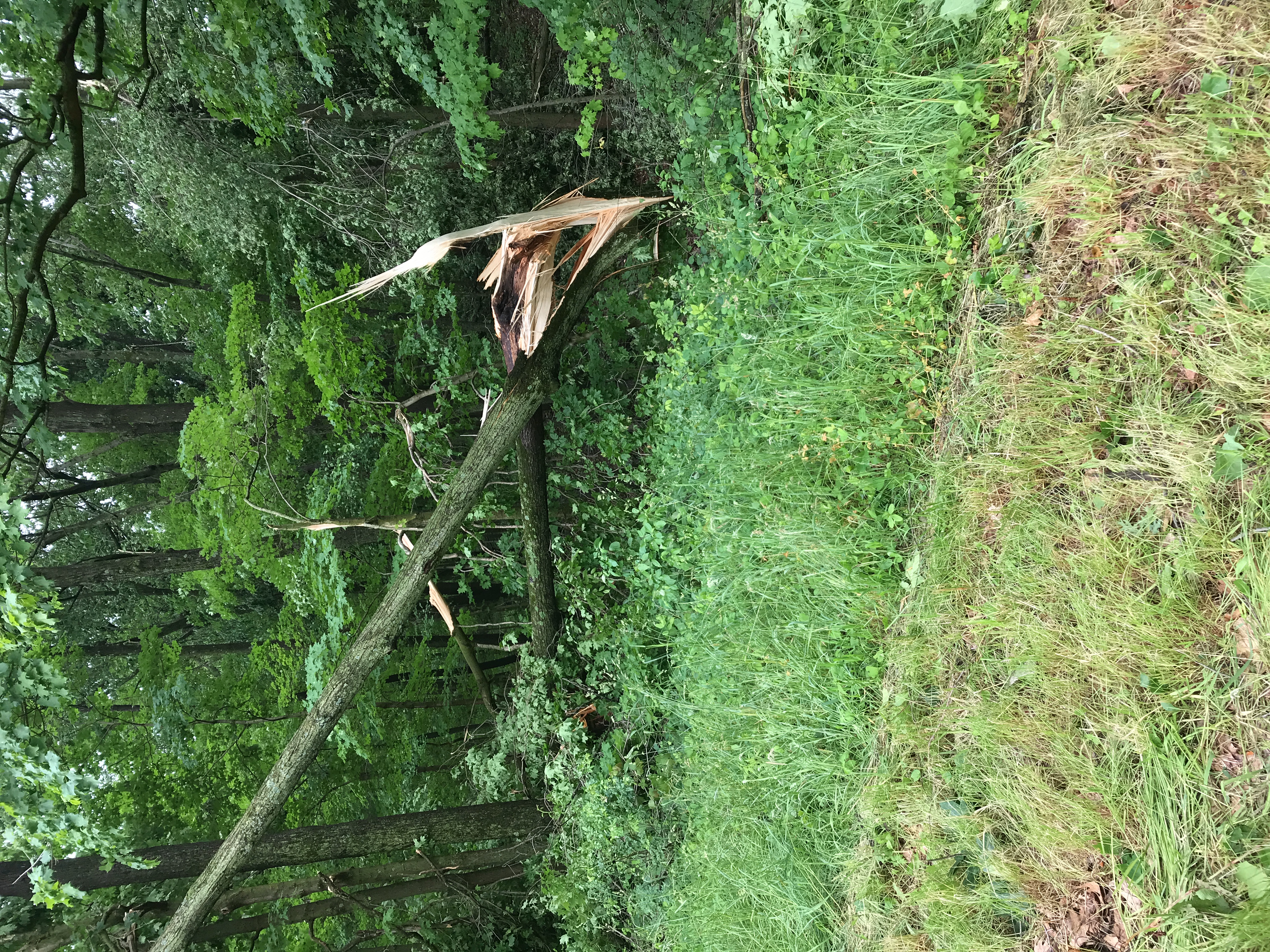 |
 |
 |
| Trees snapped and roof damage to a house. (NWS Survey) |
Tree snapped and twisted. (NWS Survey) |
Roof damage to an outbuilding. Debris from the roof was found in a nearby field. (NWS Survey) |
Damage to an outbuilding and chicken coop. (NWS Survey) |
Radar
 |
 |
 |
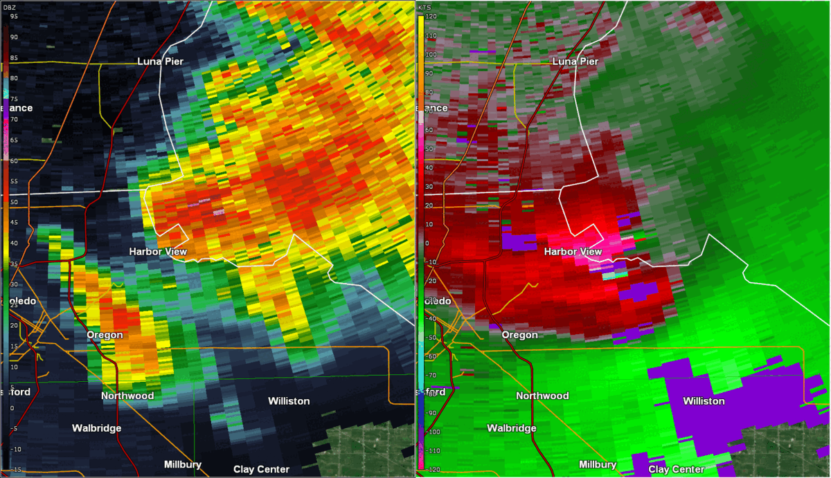 |
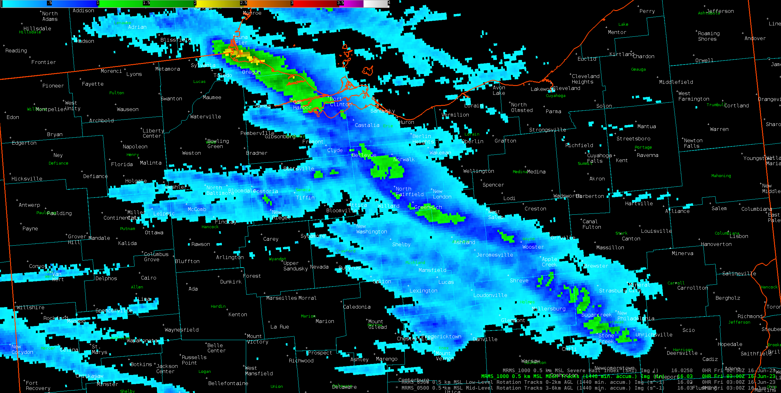
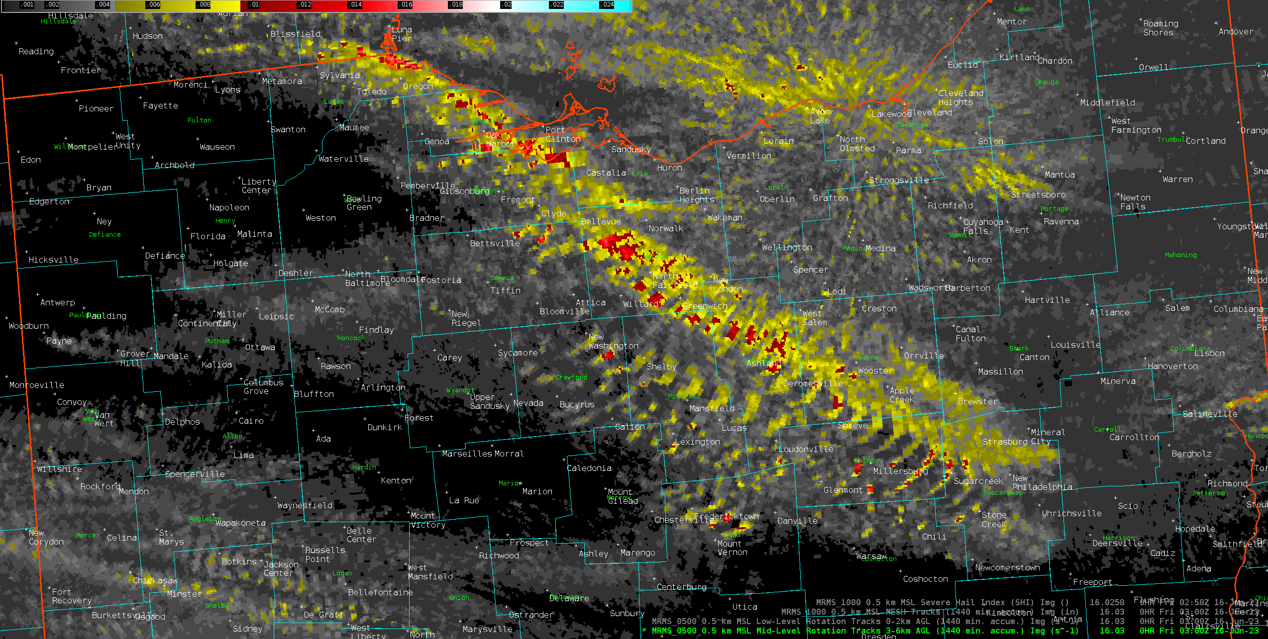
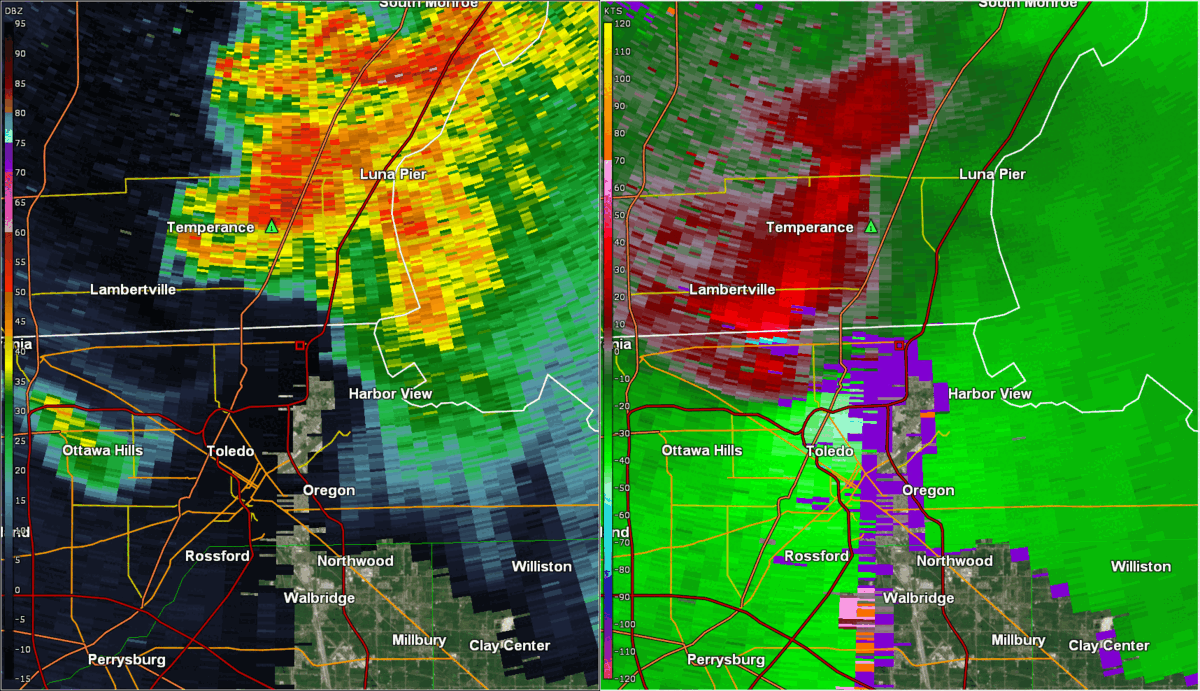
| MRMS max estimated hail size (in inches) through 11 PM June 15, 2023. Locations in green reported hail between quarter and golf ball-sized, locally larger. Locations in yellow reported hail larger than golf ball and up to at least tennis ball sized. | MRMS mid-level rotation swaths through 11 PM June 15, 2023. Note the long swath of moderate to strong rotation, associated with the dominant supercells. At times, you can see tracks of smaller cells getting ingested by the larger supercell. The supercell produced the bulk of the large hail and tornadoes, though some of the smaller cells that developed and moved into it also produced tornadoes. | Loop of the reflectivity (left) and velocity (right) from the TDTW radar valid 6:01 to 6:14 PM as a tornado developed and moved across northern Toledo and Point Place. The tornado developed just south of the stateline near US 24 at 6:06 PM before moving into the Maumee off of Point Place at 6:10 PM. The tornado clipped the shoreline near Harbor View around the end of this loop. | Loop of the reflectivity (left) and velocity (right) from the TDTW radar valid 6:19 to 6:31 PM. After grazing the shoreline near Harbor View at around 6:15 PM, the rotation stayed over Maumee Bay for a few more minutes (where videos of a waterspout were recorded) before coming back ashore near the Maumee Bay State Park as an EF-0 tornado. |
 |
 |
 |
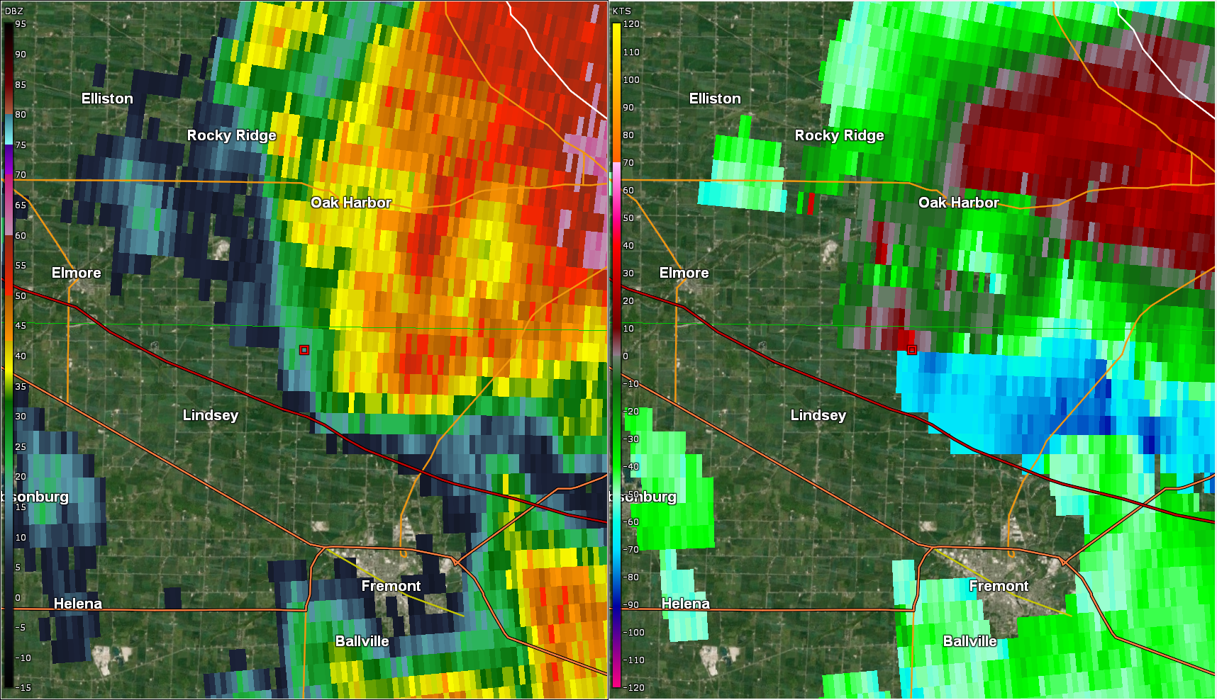 |
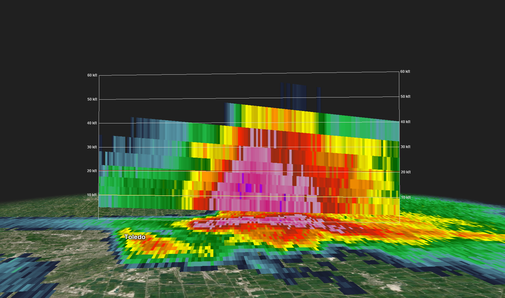
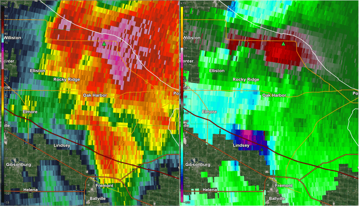
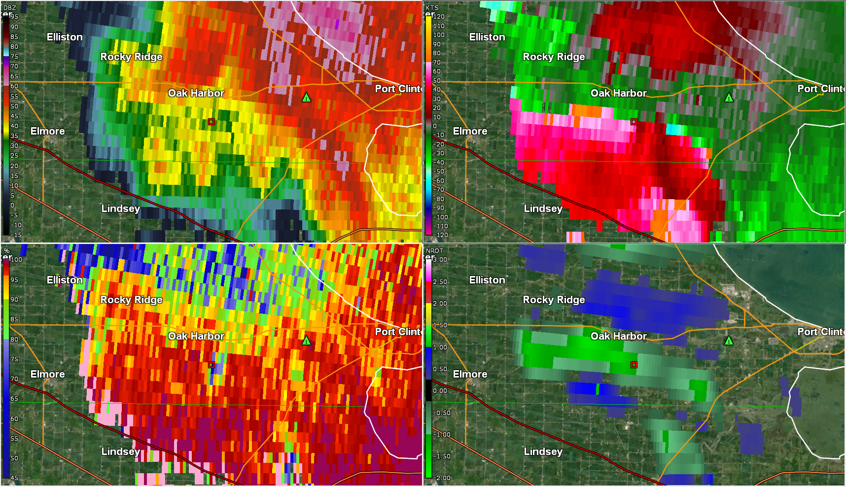
| Cross section of the supercell thunderstorm near the Lucas County shoreline at 6:16 PM June 15, 2023. Note the very large area of high returns extending from the ground to over 35,000 feet aloft, with purples in the 10,000-20,000 foot layer indicating very large hail. Hail to near baseball size was reported around this time in eastern Lucas County. | Loop from the KCLE radar valid 6:46 PM through 6:59 PM of the rotation that produced an EF-2 tornado near Oak Harbor in Ottawa County. The tornado touched down at 6:49 PM just north of the Ottawa/Sandusky County line and lifted around 6:58 PM east-southeast of Oak Harbor. The storm that produced this tornado was a smaller storm getting ingested into the larger supercell approaching from the northwest. | Reflectivity (upper left), velocity (upper right), correlation coefficient (bottom left), and normalized rotation (bottom right) from the KCLE radar valid 6:55 PM June 15, 2023. Note the area just south of Oak Harbor where lower correlation coefficient is co-located with a tight velocity couplet within an area of high reflectivity. This is a Tornado Debris signature, which was present for 2-3 radar scans with this tornado. | Reflectivity (left) and velocity (right) valid at 7:01 PM June 15, 2023 from the KCLE radar. The radar is detecting a small area of rotation between Lindsey and Oak Harbor, which is likely responsible for the brief tornado that occurred in Rice Township. This was a brief EF-0 tornado with rotation that was tricky to spot on radar. |
 |
 |
 |
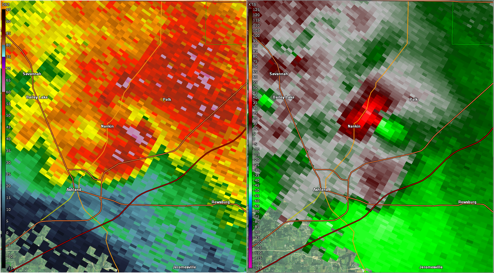 |
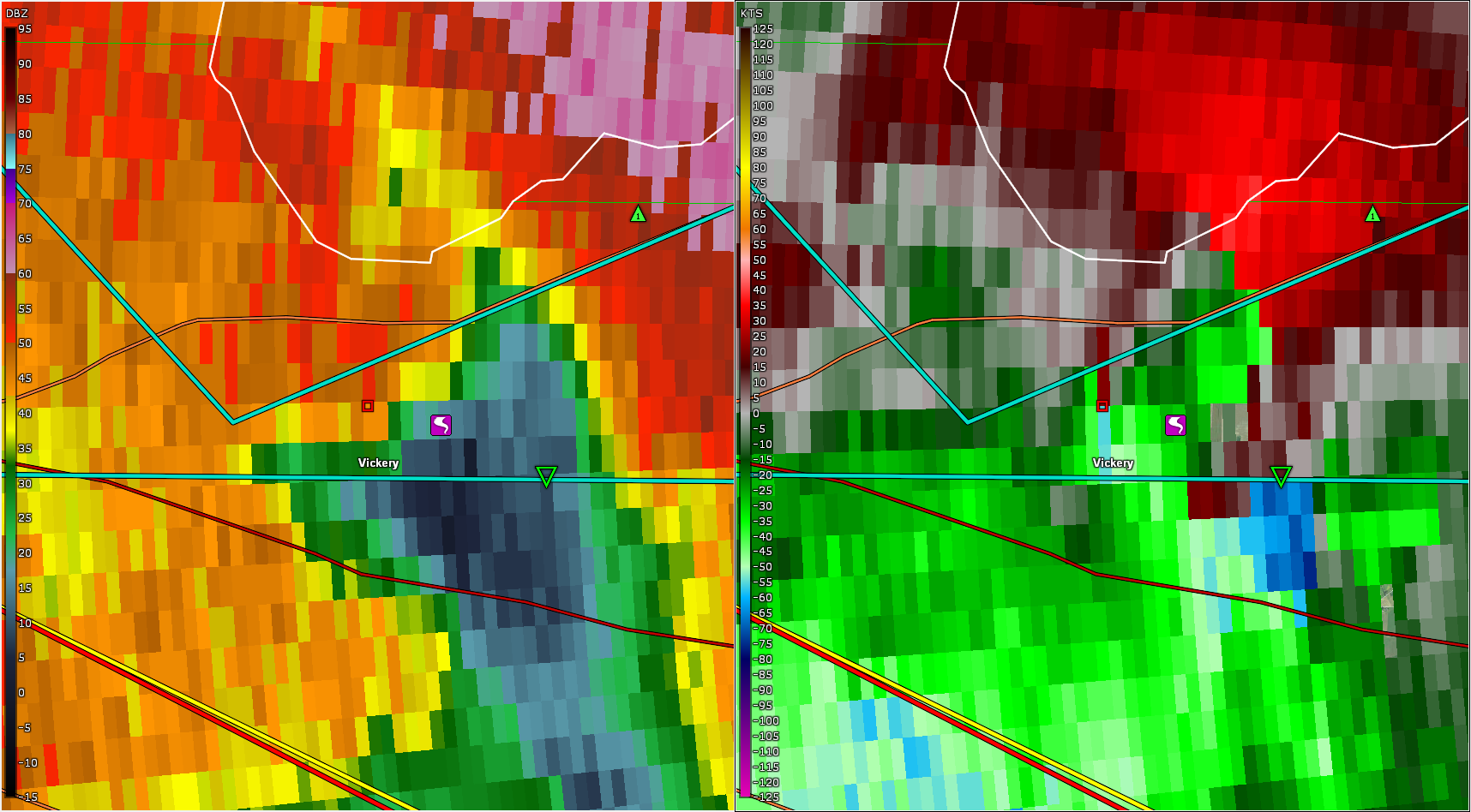
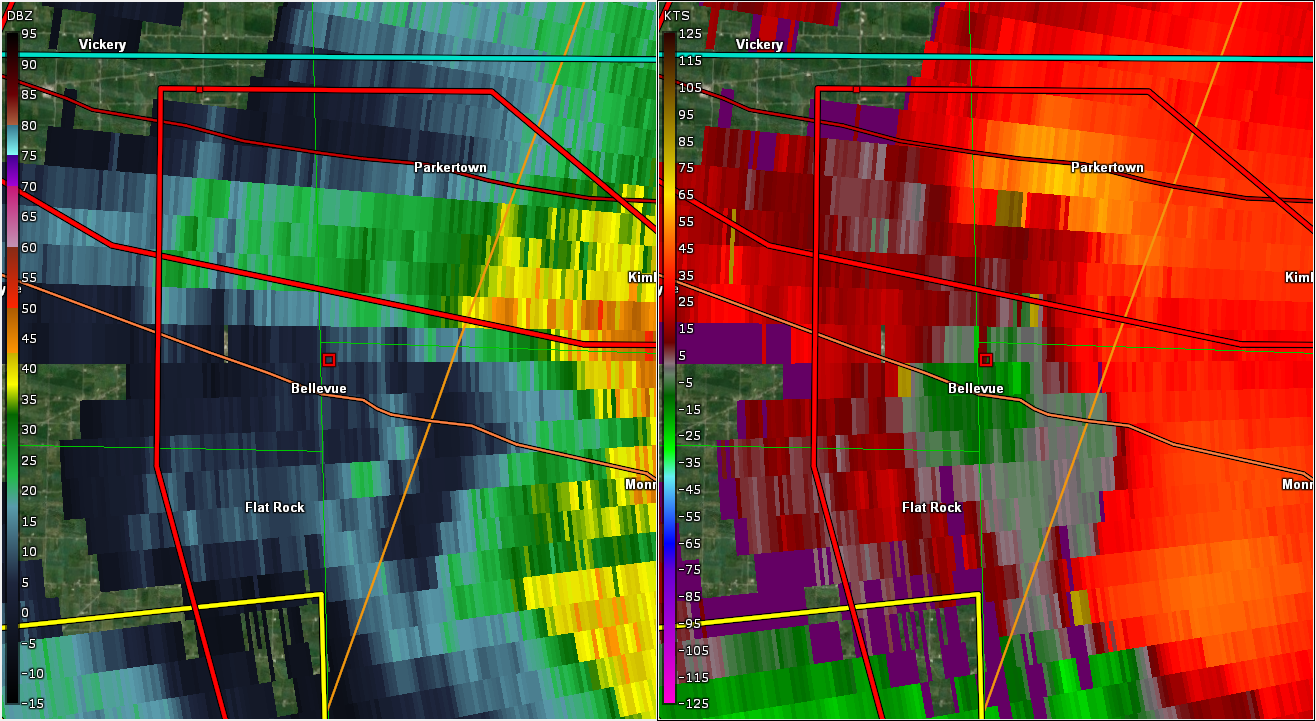
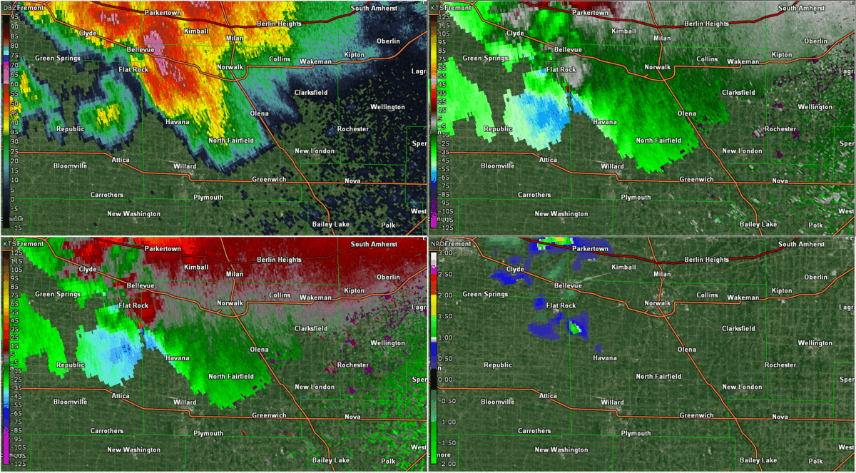
| Reflectivity (left) and velocity (right) valid at 7:19 PM from the KCLE radar as an EF-0 tornado is produced in Vickery, OH. | Reflectivity (left) and storm-relative velocity (right) valid at 7:49 PM from the TLVE radar as an EF-0 is produced in Bellevue, OH. This is one of the tornadoes with a more subtle radar feature associated with it. | Reflectivity (top left), velocity (top right), storm-relative velocity (bottom left), and normalized rotation (NROT; bottom right) displayed from KCLE radar for 7:31 PM to 8:24 PM. In this radar loop you can see a supercell track southeast across Huron County as it produces several tornadoes, the strongest of which produced EF-2 damage in Peru, OH. Many classic supercell features are observed here including the hook echo, inflow region, and a very strong mesocyclone. Rain showers near the mesocyclone were also ingested into the supercell as it intensifies. | Reflectivity (left) and velocity (right) valid at 8:46 PM from the KCLE radar as an EF-0 tornado is produced in Nankin, OH. |
Storm Reports
Click here for the Summary of Tornadoes on June 15, 2023.
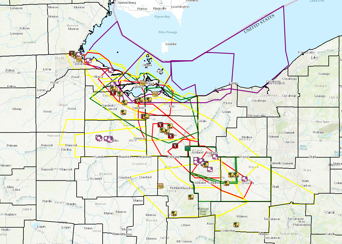
Map of all convective warnings issued by NWS Cleveland overlaid with local storm reports. Polygons outlined in yellow represent severe thunderstorm warnings. Polygons outlined in red represent tornado warnings. Polygons outlined in purple represent special marine warnings.
Preliminary Local Storm Report...Summary
National Weather Service Cleveland OH
156 PM EDT Sun Jun 18 2023
..TIME... ...EVENT... ...CITY LOCATION... ...LAT.LON...
..DATE... ....MAG.... ..COUNTY LOCATION..ST.. ...SOURCE....
..REMARKS..
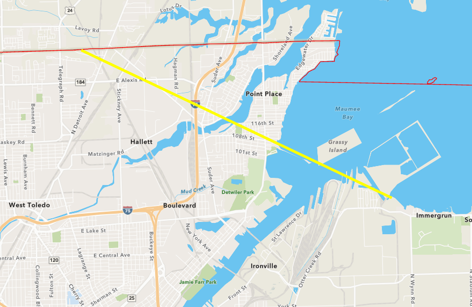
0606 PM Tornado 5 NNE Toledo 41.73N 83.54W
06/15/2023 Lucas OH NWS Storm Survey
Preliminary NWS storm survey determined an
EF-2 tornado with estimated peak winds of
130 mph and path width of 300 yards occurred
in Lucas County, OH. The tornado touched
down 5 miles north of downtown Toledo and
tracked 2 miles east into Point Place. More
details on damage to follow.
0607 PM Tstm Wnd Dmg 4 WNW Harbor View 41.72N 83.52W
06/15/2023 Lucas OH 911 Call Center
Multiple utility poles down and report of a
roof blown off of a house in Washington
Township. Time estimated via radar.
0609 PM Tstm Wnd Dmg 3 WNW Harbor View 41.71N 83.50W
06/15/2023 Lucas OH Broadcast Media
Numerous reports of trees snapped and
structural damage, including roofs ripped
off buildings, in Point Place. Possible
tornado.
0610 PM Tstm Wnd Dmg 2 NW Harbor View 41.71N 83.48W
06/15/2023 Lucas OH Public
Numerous trees snapped. Minor damage to a
vehicle reported as well as minor damage to
a roof. Time estimated via radar.
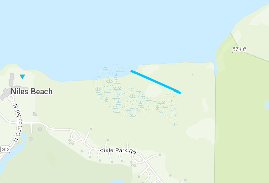
0610 PM Hail 2 ENE Oregon 41.68N 83.38W
06/15/2023 E1.75 inch Lucas OH Public
Large hail reported in Maumee Bay State
Park. Time estimated via radar.
0615 PM Hail 3 NW Harbor View 41.72N 83.48W
06/15/2023 M2.00 inch Lucas OH Trained Spotter
0615 PM Hail 2 NW Harbor View 41.71N 83.48W
06/15/2023 E2.50 inch Lucas OH Public
Report from mPING: Tennis Ball (2.50 in.).
0616 PM Hail 2 NNW Harbor View 41.72N 83.47W
06/15/2023 M2.00 inch Lucas OH Trained Spotter
Time estimated via radar.
0618 PM Tstm Wnd Gst 1 W Harbor View 41.69N 83.47W
06/15/2023 M66 MPH Lucas OH Buoy
Buoy station THRO1 Toledo, OH.
0642 PM Hail 6 NNE Rocky Ridge 41.61N 83.17W
06/15/2023 M1.25 inch Ottawa OH Trained Spotter
0648 PM Hail Oak Harbor 41.51N 83.15W
06/15/2023 E1.00 inch Ottawa OH Public
Time estimated via radar.
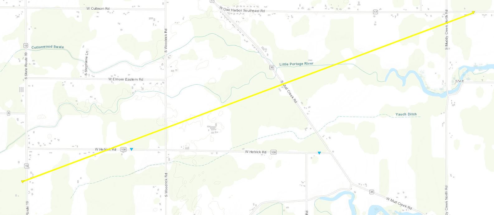
0649 PM Tornado 3 S Oak Harbor 41.47N 83.15W
06/15/2023 Ottawa OH NWS Storm Survey
Preliminary NWS storm survey determined an
EF-2 tornado with estimated peak winds of
130 mph and a path width of 200 yards
occurred south of Oak Harbor in Ottawa
County, OH. The tornado was on the ground
for approximately 9 minutes and tracked 3.45
miles to the east-northeast, damaging
multiple homes and destroying several barns.
0650 PM Tstm Wnd Dmg 3 SSE Oak Harbor 41.47N 83.13W
06/15/2023 Ottawa OH Emergency Mngr
Damage to multiple houses near Hetrick and
Bloom Roads. Possible tornado damage.
0650 PM Tstm Wnd Dmg 3 SSE Oak Harbor 41.47N 83.13W
06/15/2023 Ottawa OH Public
Damage to vehicles and farm buildings.
Pictures via social media. Possible tornado
damage.
0652 PM Tstm Wnd Dmg 6 SE Oak Harbor 41.44N 83.08W
06/15/2023 Sandusky OH Emergency Mngr
Emergency manager reported storm damage in
Rice Twp. Possible tornado.
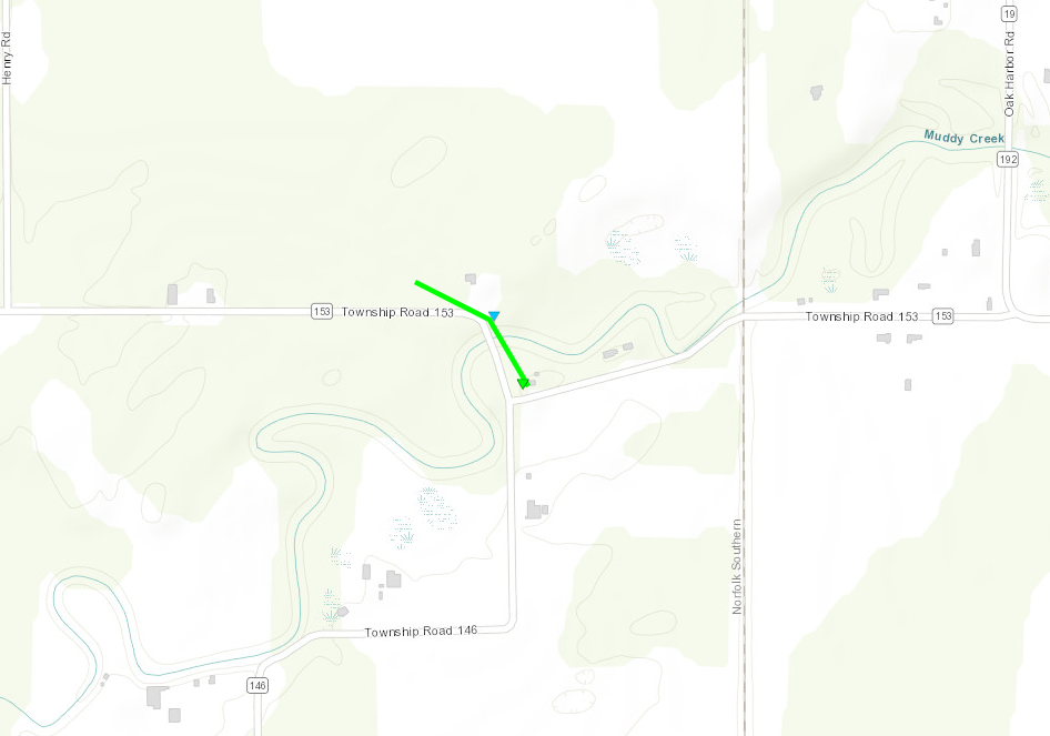
0657 PM Tornado 4 ENE Lindsey 41.45N 83.15W
06/15/2023 Sandusky OH NWS Storm Survey
An EF-1 tornado with estimated maximum winds
of 95 mph and a width of 100 yards briefly
touched down near the intersection of
Township Road 153 and Township Road 146 in
Rice Township, OH. The tornado blew down
multiple trees, two of which fell onto a
house. The tornado was on the ground for
0.15 miles.
0657 PM Tstm Wnd Dmg 2 S Oak Harbor 41.48N 83.15W
06/15/2023 Ottawa OH Broadcast Media
Several reports of structural damage along
and around State Route 19 south of Oak
Harbor in Ottawa County. Damage includes
siding damage, outbuilding wall failure, and
a roof blown off of a barn. Reports of trees
down as well. Time estimated via radar.
0718 PM Tornado 6 W Castalia 41.39N 82.92W
06/15/2023 Sandusky OH NWS Storm Survey
Delayed report. An NWS Cleveland storm
survey confirms an EF-0 tornado briefly
touched down in Sandusky County east of
Vickery on June 15, 2023. The tornado
touched down along CR 247 partially
destroying a metal roof of an outbuilding
and throwing roofing into a field. Tornado
tracked east southeast for a third of a mile
across Schertz Ditch and continued into a
tree line. Shingles from a home were thrown
back toward the west. The maximum width was
50 yards.
0718 PM Tstm Wnd Dmg 5 ENE Fremont 41.38N 83.04W
06/15/2023 Sandusky OH Public
Multiple trees snapped and powerlines down
along the Turnpike/I-80. Time estimated via
radar.
0720 PM Tstm Wnd Dmg 4 W Castalia 41.40N 82.89W
06/15/2023 Sandusky OH Public
Outbuilding destroyed with debris scattered
into field near US-6 and County Road 298.
Time estimated via radar.
0722 PM Tstm Wnd Dmg 2 WSW Sandusky 41.44N 82.75W
06/15/2023 Erie OH Trained Spotter
Poles snapped along US-6.
0727 PM Tstm Wnd Dmg 4 N Green Springs 41.31N 83.05W
06/15/2023 Sandusky OH Public
Barn collapse. Time estimated via radar.
0727 PM Tstm Wnd Dmg Castalia 41.40N 82.81W
06/15/2023 Erie OH Trained Spotter
Numerous trees and powerlines down.
0729 PM Hail Bellevue 41.28N 82.84W
06/15/2023 M1.75 inch Sandusky OH Trained Spotter
0729 PM Hail 1 W Bellevue 41.28N 82.86W
06/15/2023 M1.50 inch Sandusky OH Emergency Mngr
0729 PM Hail 1 W Bellevue 41.28N 82.86W
06/15/2023 M1.50 inch Sandusky OH Emergency Mngr
0731 PM Tstm Wnd Dmg Bellevue 41.28N 82.84W
06/15/2023 Huron OH Public
Trees snapped along Northwest Street.
0731 PM Tstm Wnd Dmg Bellevue 41.28N 82.84W
06/15/2023 Huron OH Public
Trees snapped along Northwest Street.
0732 PM Hail Bellevue 41.28N 82.84W
06/15/2023 M1.75 inch Huron OH Trained Spotter
A trained spotter reported golf ball sized
hail near SR 269 and Lincoln Street in
Bellevue.
0735 PM Tstm Wnd Gst 4 E Port Clinton 41.52N 82.87W
06/15/2023 M40 MPH Ottawa OH AWOS
AWOS station KPCW Port Clinton reported a 35
kt wind gust.
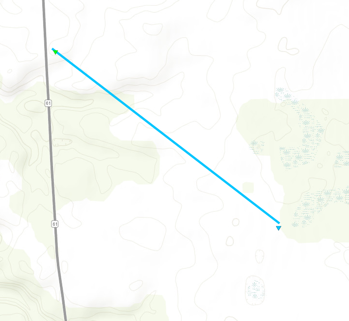
0740 PM Tornado 1 NW Bellevue 41.28N 82.85W
06/15/2023 Sandusky OH NWS Storm Survey
A preliminary NWS storm survey confirms an
EF-0 tornado with estimated maximum winds of
80 mph and a width of 500 yards began in
northern Bellevue. The tornado tracked 0.93
miles southeast and knocked over multiple
power poles and snapped large branches off
the tops of several trees before
dissipating.
0740 PM Tstm Wnd Dmg 1 N Bellevue 41.28N 82.83W
06/15/2023 Huron OH Public
Large trees downed just north of Bellevue.
Time estimated via radar.
0748 PM Tornado 2 S Monroeville 41.22N 82.70W
06/15/2023 Huron OH NWS Storm Survey
Updates previous tornado report from 2 S
Monroeville. An NWS Cleveland Storm Survey
confirms an EF-2 tornado with a maximum
estimated wind speed of 115 mph occurred in
Huron County on June 15 2023. This tornado
started 2 miles south of Monroeville and
extended 9.43 miles to 1 mile west-northwest
of North Fairfield. The tornado had a
maximum width of 1100 yards.
0749 PM Hail Bascom 41.13N 83.29W
06/15/2023 M1.00 inch Seneca OH Trained Spotter
Trained spotter reported quarter sized hail
in Bascom.
0751 PM Tstm Wnd Dmg 1 N Bellevue 41.28N 82.84W
06/15/2023 Sandusky OH Public
Multiple trees down north of Bellevue.
Report obtained on social media and time
estimated via radar.
0751 PM Tstm Wnd Dmg 5 NNW North Fairfield 41.17N 82.64W
06/15/2023 Huron OH Public
Large tree uprooted. Time estimated via
radar.
0752 PM Hail 2 W Tiffin 41.12N 83.21W
06/15/2023 E1.75 inch Seneca OH Emergency Mngr
Golf ball sized hail between Bascom and
Tiffin.
0752 PM Hail 5 W Tiffin 41.12N 83.28W
06/15/2023 E1.25 inch Seneca OH Public
Report from mPING: Half Dollar (1.25 in.).
0753 PM Hail Tiffin 41.12N 83.18W
06/15/2023 M1.00 inch Seneca OH Trained Spotter
0753 PM Tstm Wnd Dmg 5 S Monroeville 41.18N 82.68W
06/15/2023 Huron OH Public
Damage to houses and outbuildings. Numerous
trees and powerlines down. Possible tornado
damage. Time estimated via radar.
0755 PM Tstm Wnd Dmg 2 S Norwalk 41.21N 82.61W
06/15/2023 Huron OH Trained Spotter
Metal Barn partially destroyed on Ridge
Road.
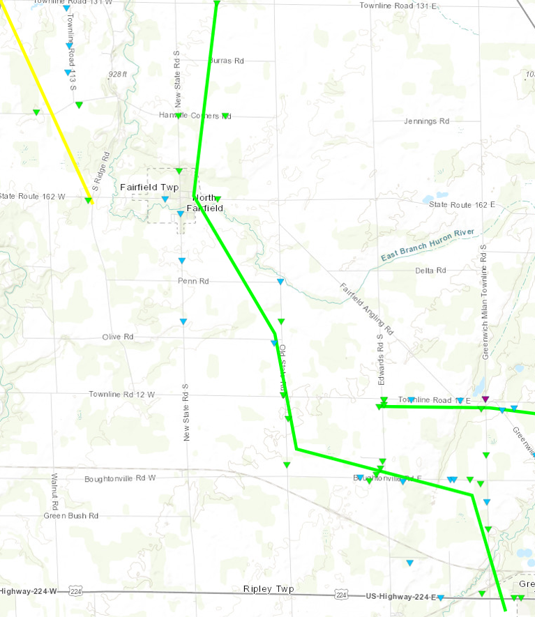
0759 PM Tornado 2 NNE North Fairfield 41.14N 82.60W
06/15/2023 Huron OH NWS Storm Survey
An NWS Cleveland Storm Survey confirms an
EF-1 tornado with a maximum wind speed of
110 mph occurred in Huron County on June 15
2023. This tornado started 2 miles north of
North Fairfield and extended 9.92 miles to 1
mile west-southwest of Greenwich. The
tornado had a maximum width of 1100 yards.
0804 PM Tstm Wnd Dmg 3 SE North Fairfield 41.07N 82.56W
06/15/2023 Huron OH Trained Spotter
House damaged on Edward Road.
0806 PM Hail Tiffin 41.11N 83.18W
06/15/2023 E1.00 inch Seneca OH Public
Report from mPING: Quarter (1.00 in.).
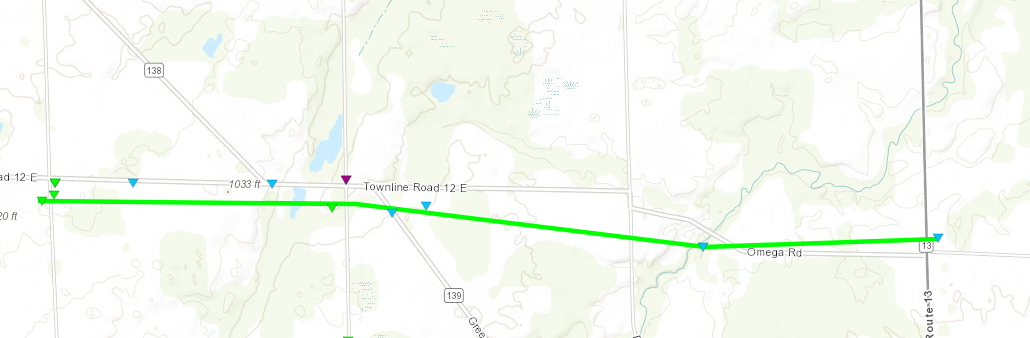
0818 PM Tornado 3 NW Greenwich 41.07N 82.56W
06/15/2023 Huron OH NWS Storm Survey
An NWS Cleveland Storm Survey confirms an
EF-1 tornado with a maximum wind speed of
105 mph occurred in Huron County on June 15
2023. This tornado started 3 miles northwest
of Greenwich and extended 4.05 miles to 3
miles north-northeast of Greenwich. The
tornado had a maximum width of 250 yards.
0832 PM Hail Savannah 40.97N 82.36W
06/15/2023 M1.75 inch Ashland OH Fire Dept/Rescue
0835 PM Hail 2 E Bailey Lakes 40.96N 82.31W
06/15/2023 E1.25 inch Ashland OH Public
Report from mPING: Half Dollar (1.25 in.).
0837 PM Hail Bailey Lakes 40.95N 82.36W
06/15/2023 M2.25 inch Ashland OH Public
Picture submitted via social media.
0846 PM Hail 3 NNE Polk 40.99N 82.18W
06/15/2023 E1.50 inch Ashland OH Public
Time estimated via radar.
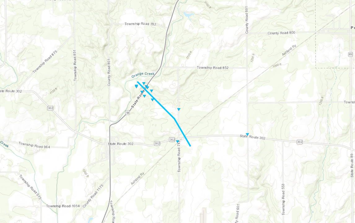
0847 PM Tornado 3 WSW Polk 40.94N 82.27W
06/15/2023 Ashland OH NWS Storm Survey
Preliminary NWS storm survey determined an
EF-0 tornado with estimated winds of 85 mph
and an estimated width of 300 yards touched
down 1 mile north-northeast of Nankin, OH
and tracked southeast for 1.2 miles. The
tornado uprooted trees and damaged multiple
outbuildings and a residence.
0849 PM Hail 3 E Bailey Lakes 40.94N 82.29W
06/15/2023 E1.75 inch Ashland OH Public
Report from mPING: Golf Ball (1.75 in.).
0850 PM Tstm Wnd Dmg 3 WSW Polk 40.93N 82.27W
06/15/2023 Ashland OH Public
Numerous trees down along SR 58 between
County Rd 801 and 852.
0850 PM Hail 3 SW Polk 40.90N 82.23W
06/15/2023 E1.75 inch Ashland OH Public
0914 PM Tstm Wnd Dmg 5 SSE Congress 40.86N 82.03W
06/15/2023 Wayne OH Emergency Mngr
Tree downed across Smithville Western Road
in Chester Twp. Time estimated via radar.
0916 PM Tstm Wnd Dmg 7 E Jeromesville 40.80N 82.07W
06/15/2023 Wayne OH 911 Call Center
Tree down on South Firestone Road.
0920 PM Tstm Wnd Dmg 4 NW Wooster 40.86N 81.98W
06/15/2023 Wayne OH 911 Call Center
Tree down on Mechanicsburg Road.
0925 PM Hail 2 ENE Wooster 40.83N 81.90W
06/15/2023 E1.50 inch Wayne OH Public
Reported via photo on social media. Time
estimated via radar.
0930 PM Tstm Wnd Dmg 2 ESE Crestline 40.78N 82.70W
06/15/2023 Richland OH 911 Call Center
Tree reported down on North Horning Road.
0936 PM Tstm Wnd Dmg 1 E Lucas 40.70N 82.41W
06/15/2023 Richland OH 911 Call Center
Large tree down on Route 39.
1000 PM Flood 3 SW New London 41.05N 82.44W
06/15/2023 Huron OH Public
Social media report that US 250 was
impassable due to flooding near the Ashland
County line. Time estimated.
1012 PM Tstm Wnd Dmg 4 SW Bellville 40.58N 82.57W
06/15/2023 Richland OH NWS Employee
Two trees downed on property southwest of
Bellville. Time estimated via radar.
1025 PM Tstm Wnd Dmg Killbuck 40.50N 81.98W
06/15/2023 Holmes OH 911 Call Center
Tree down.
&&
$$
Environment
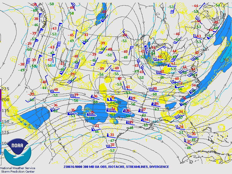
Surface low pressure developed over Southeast Michigan on Thursday June 15, 2023 in advance of an upper level trough deepening across the Central Great Lakes. A jet streak at 500mb rounded the base of the trough during the evening, supporting severe thunderstorm development. Effective bulk shear increased to 40-50 knots during the evening across northwest and north central Ohio. Meanwhile a warm front extended southeast from near Toledo towards Ashland, with this warm front likely becoming enhanced by a lake breeze near the western shoreline of Lake Erie in parts of Lucas, Ottawa, and Sandusky Counties.
 |
 |
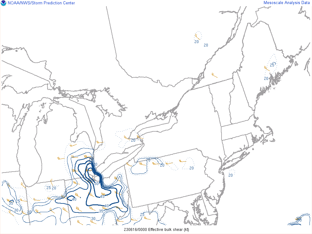 |
| June 15,2023 8 PM 300mb obs, wind, divergence | June 15, 2023 WPC Surface Analysis/Fronts Loop | June 15, 2023 8 PM Effective Bulk Shear |
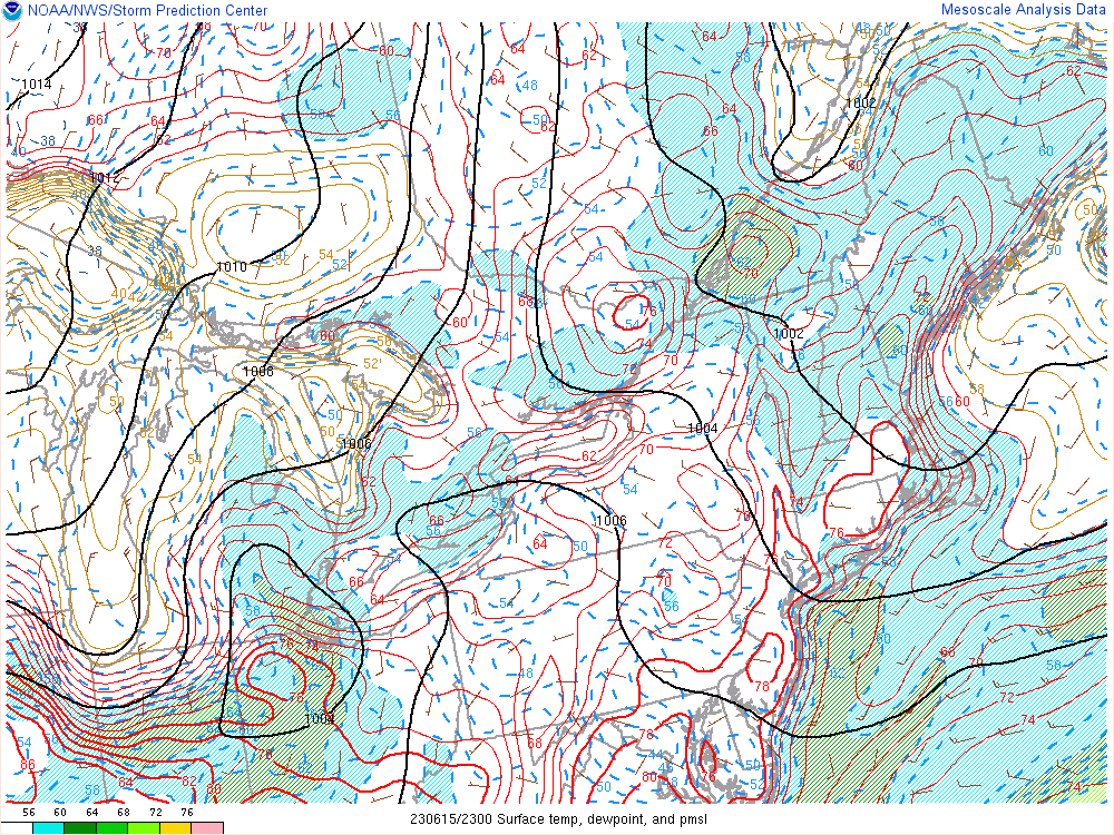
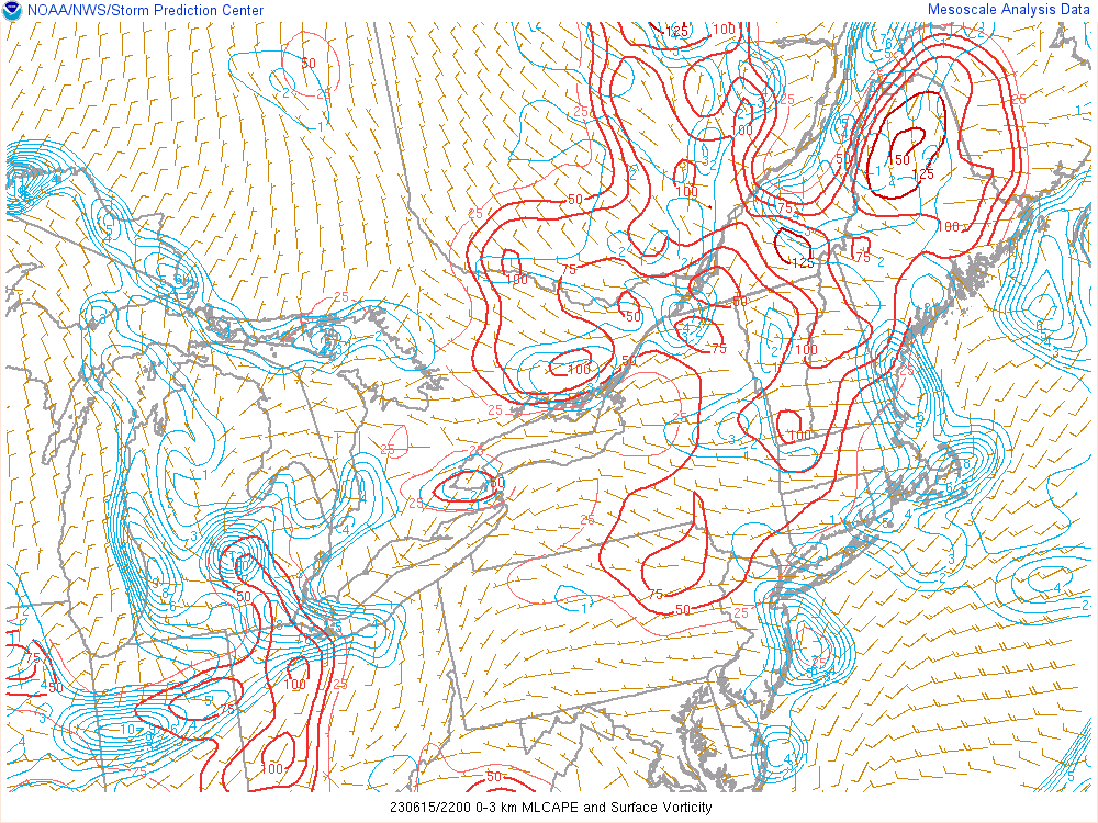
At 6 PM surface low pressure was located near the west end of Lake Erie and the Toledo area. The temperature at Toledo peaked at 83 degrees at 7:01 PM EDT, right after the tornadic supercell had moved through Lucas County. The dewpoint reached 61 degrees ahead of the storms. The atmosphere became considerably more favorable for severe thunderstorms development between 4 and 7 PM as southwest winds ramped up, pushing mixed layer CAPE from around 500 J/kg to 1500 J/kg across Northwest Ohio. Storms moving southeast out of Michigan encountered very strong and rapidly increasing surface vorticity as they approached the Lake Erie shoreline due to the warm front and lake breeze. This resulted in the tornado developing just north of Toledo at 606 PM EDT and a tornado developing at 609 PM EDT a half mile north northwest of Detroit Beach in Monroe County, Michigan.
 |
 |
 |
| June 15, 2023 Temperature and Dewpoint |
June 15, 2023 6 PM 0-3km MLCAPE and Surface Vorticity |
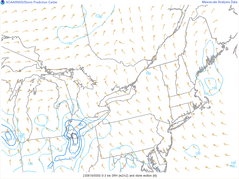
June 15, 2023 8 PM 0-3 km SRH (m2/s2) and storm motion |
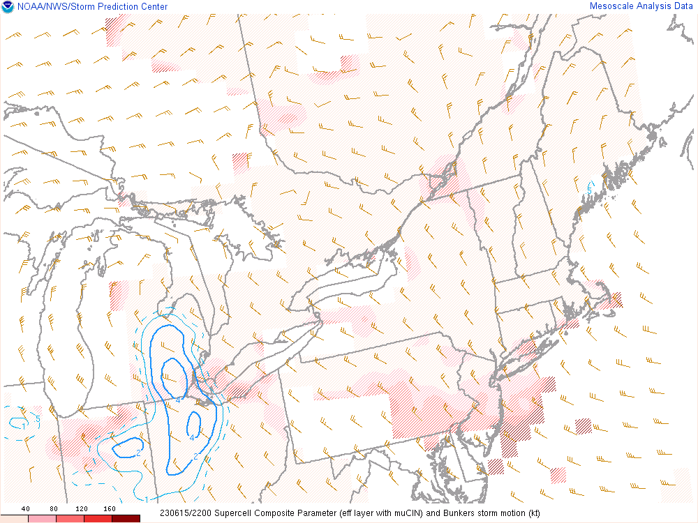
One parameter that was not as favorable for tornado development was the Lifting Condensation Level or LCL. The LCL was estimated to be around 1250 m when the first tornado occurred. Values of 500-800 m are more conducive to tornado development. More investigation is needed to see if values may have actually been lower in the vicinity of Lake Erie. Two other parameters that were worth noting with relatively high values for Ohio include the Supercell Composite Parameter which peaked at 4 and the Large Hail Parameter which peaked at a value of 8.
.gif) |
 |
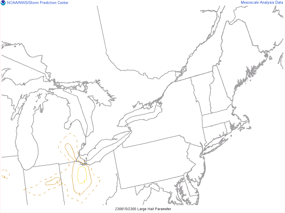 |
| June 15, 2023 7 PM LCL Height | June 15, 2023 6 PM Supercell Composite | June 15, 2023 7 PM Large Hail Parameter |
 |
Media use of NWS Web News Stories is encouraged! Please acknowledge the NWS as the source of any news information accessed from this site. |
|