Overview
|
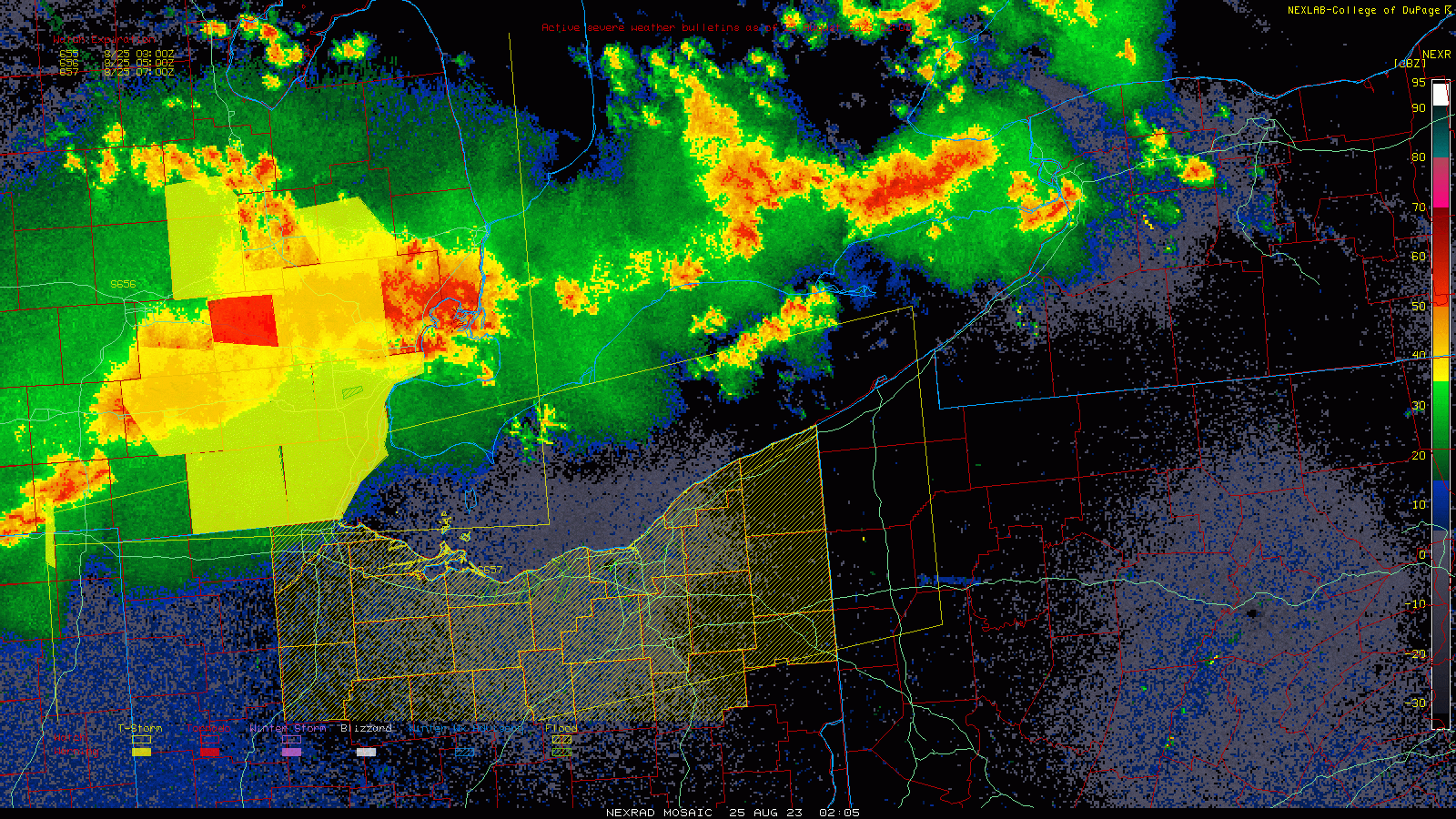
Strong thunderstorms developed along a cold front across the Central and Lower Great Lakes during the late evening and overnight hours of August 24-25, 2023. These thunderstorms were in an environment of strong to extreme instability, along with sufficient low-level and deep-layer wind shear for organized and rotating thunderstorms. This allowed storms that developed over Michigan to organize into a fast-moving cluster of thunderstorms that produced extensive wind damage and a number of tornadoes between southern Lower Michigan and southwestern Pennsylvania, hitting much of northern Ohio hard. A number of measured or estimated straight-line wind gusts over 75 MPH occurred in the Cleveland area and across Northeast Ohio, to go along with 12 confirmed tornadoes in our forecast area. At its peak, nearly 250,000 customers across the area were without power. Of particular note, the EF-1 that occurred on the east side of Cleveland was the first tornado that occurred within the Cleveland city limits since July 12, 1992. Two EF-2 tornadoes occurred; one in Warrensville Heights and Bedford Heights in Cuyahoga County and another in Middlefield in Geauga County. |
|
Tornadoes:
|
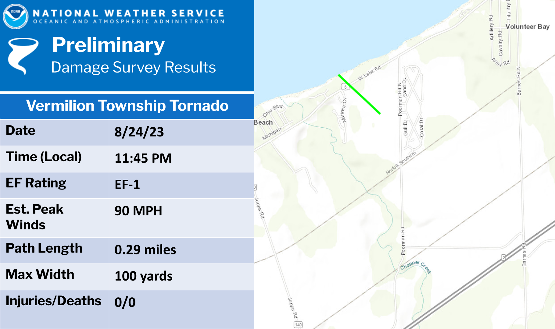
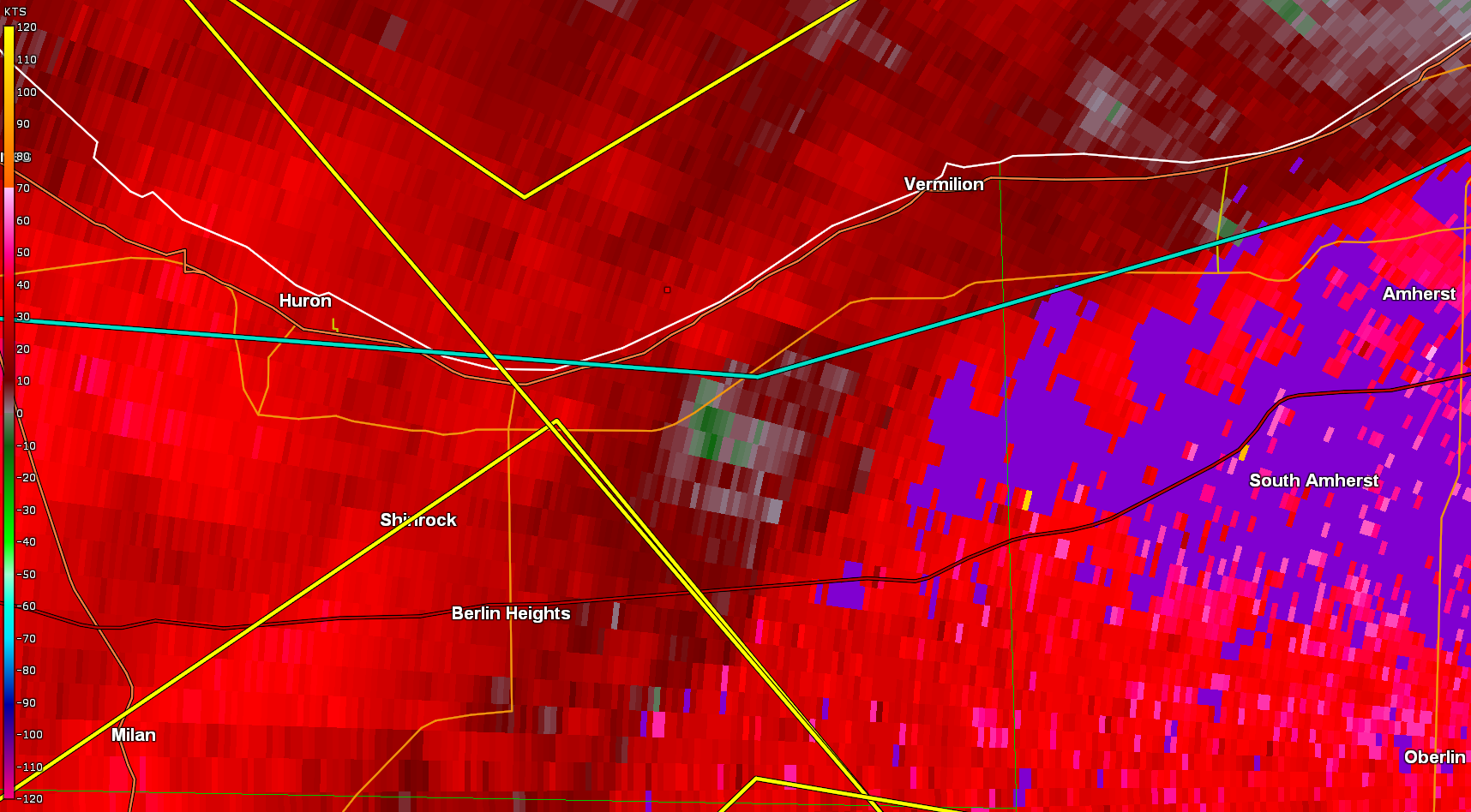
Tornado - Vermilion Township, OH
|
||||||||||||||||
|
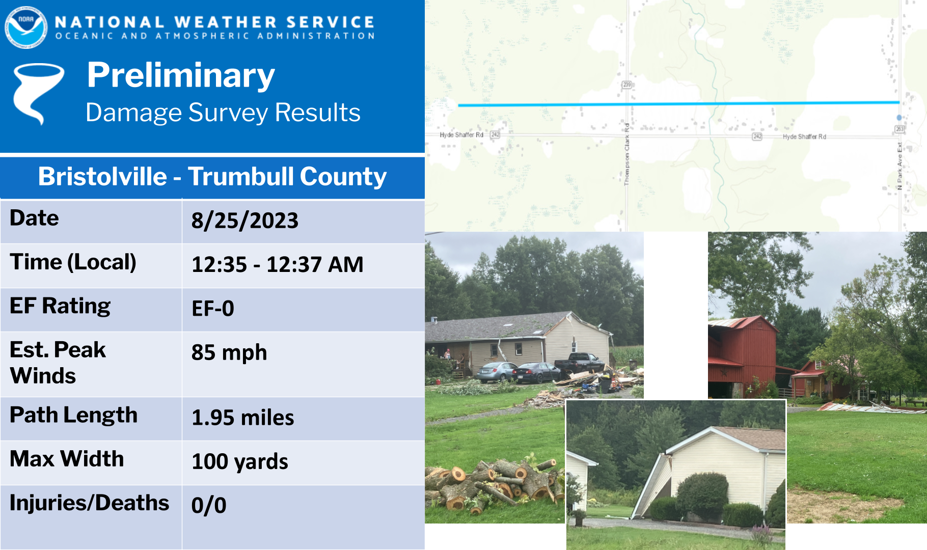
Tornado - Bristolville, OH
|
||||||||||||||||
|
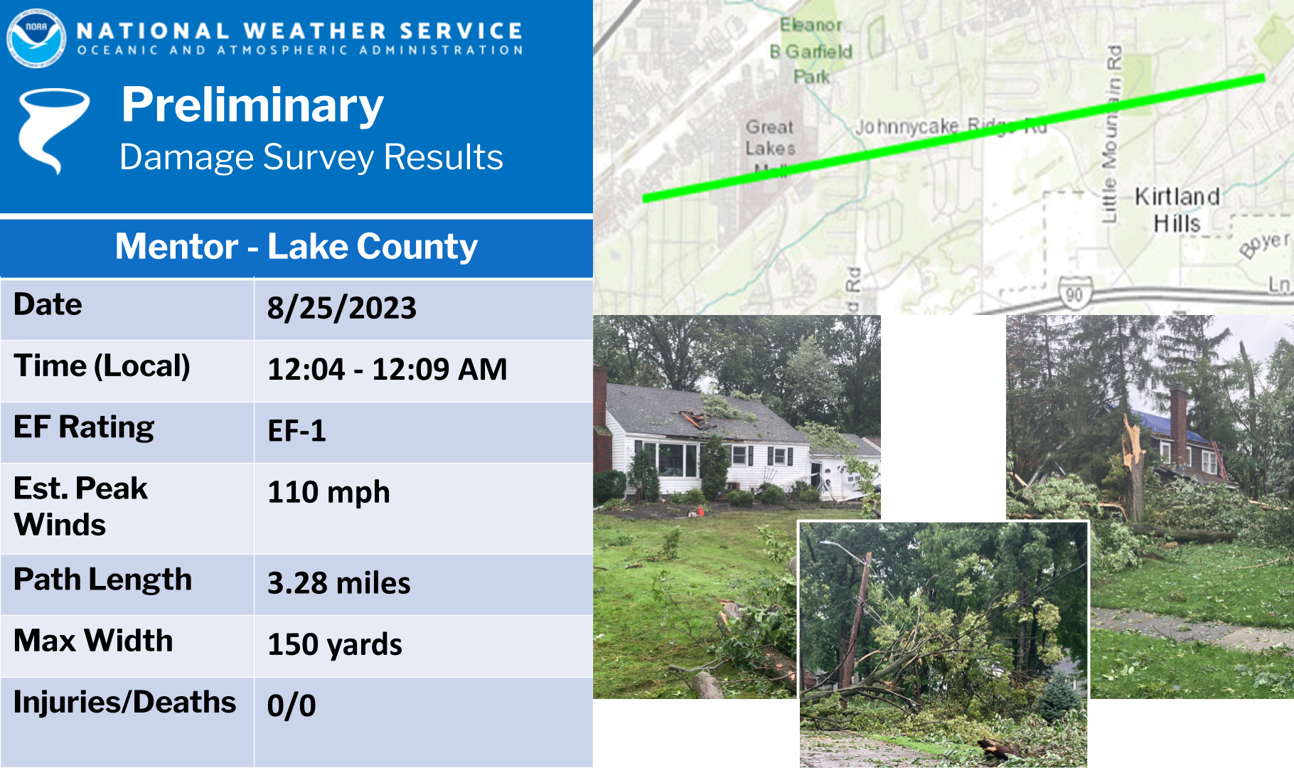
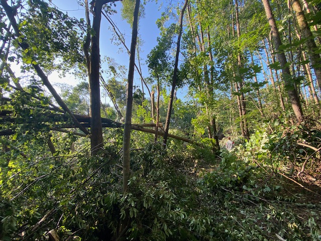
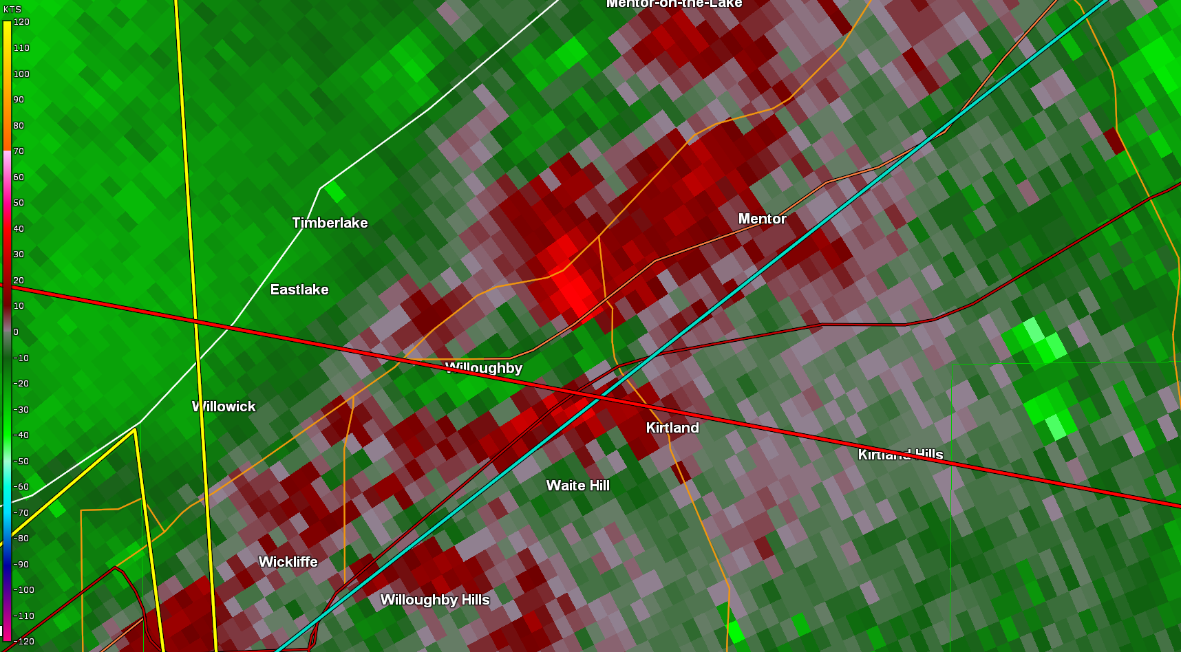
Tornado - Mentor, OH
|
||||||||||||||||
|
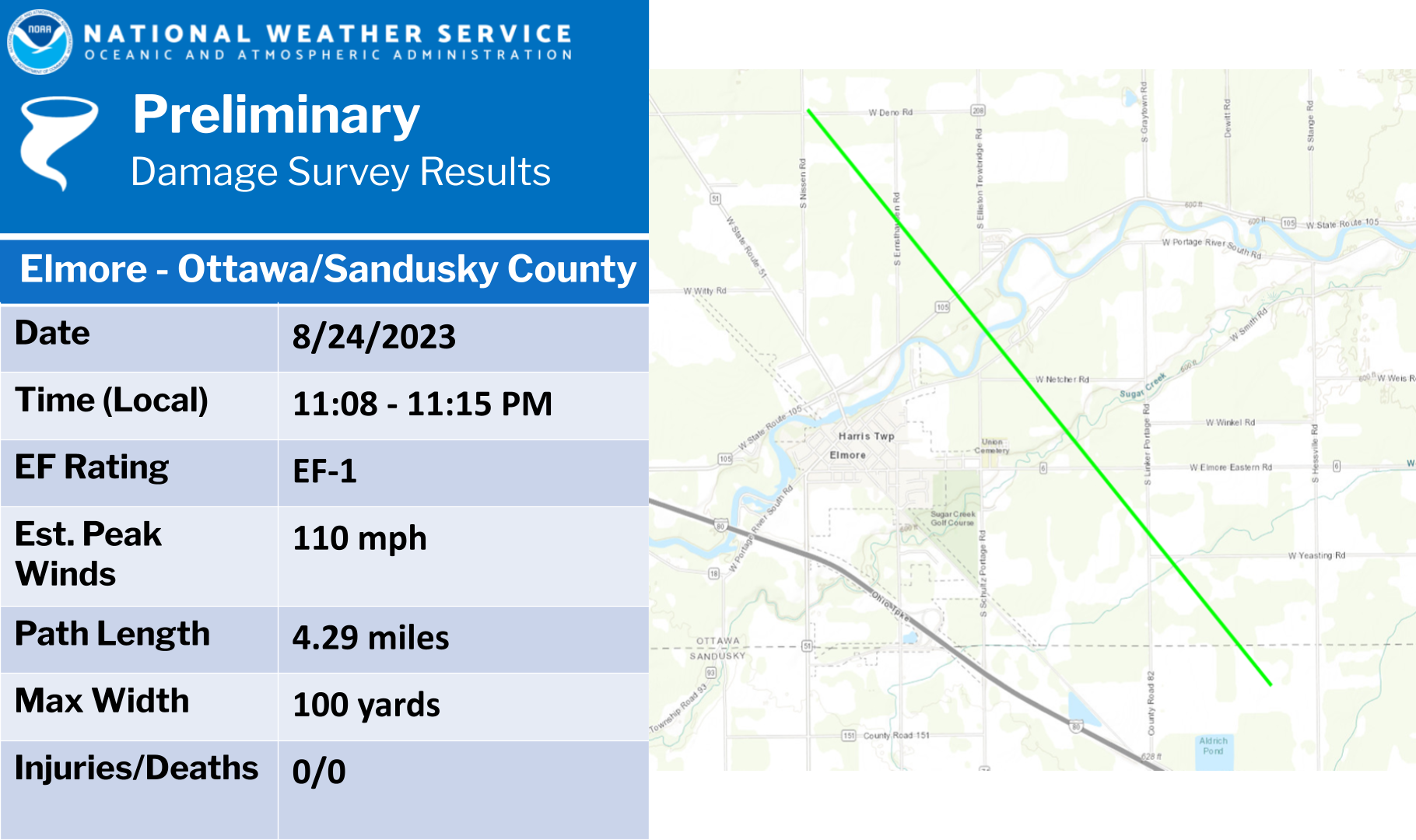
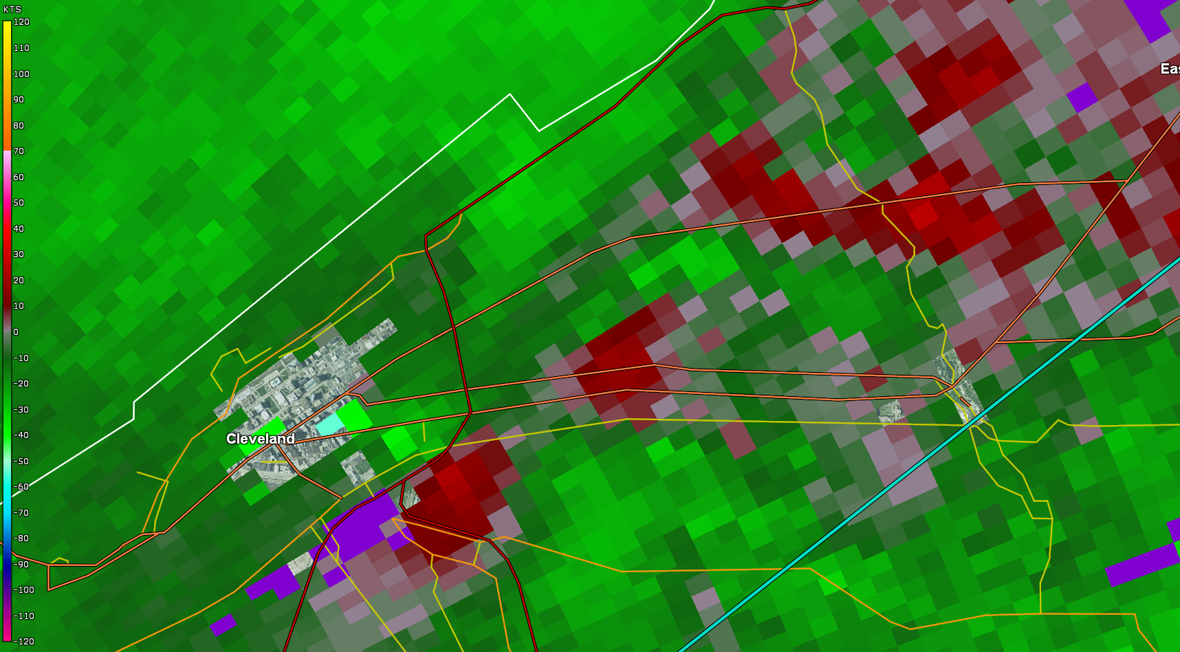
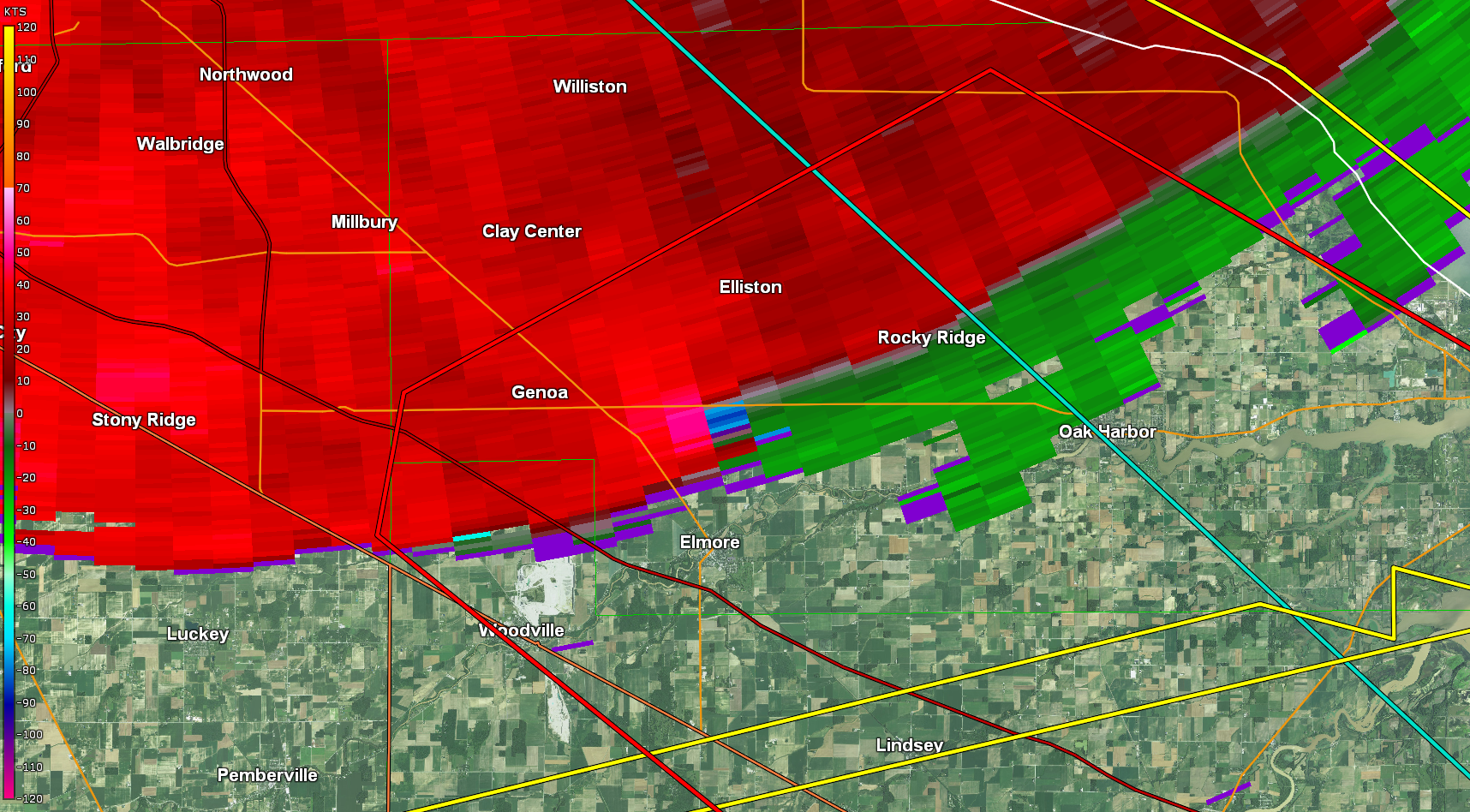
Tornado - Elmore, OH
|
||||||||||||||||
|
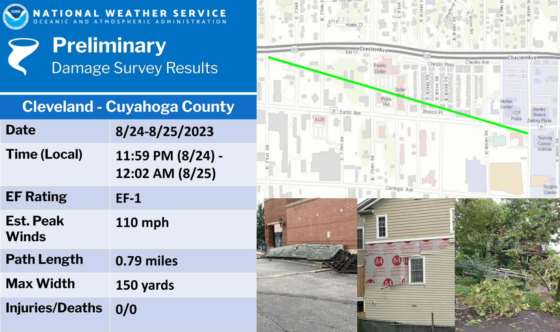
Tornado - Cleveland, OH
|
||||||||||||||||
|
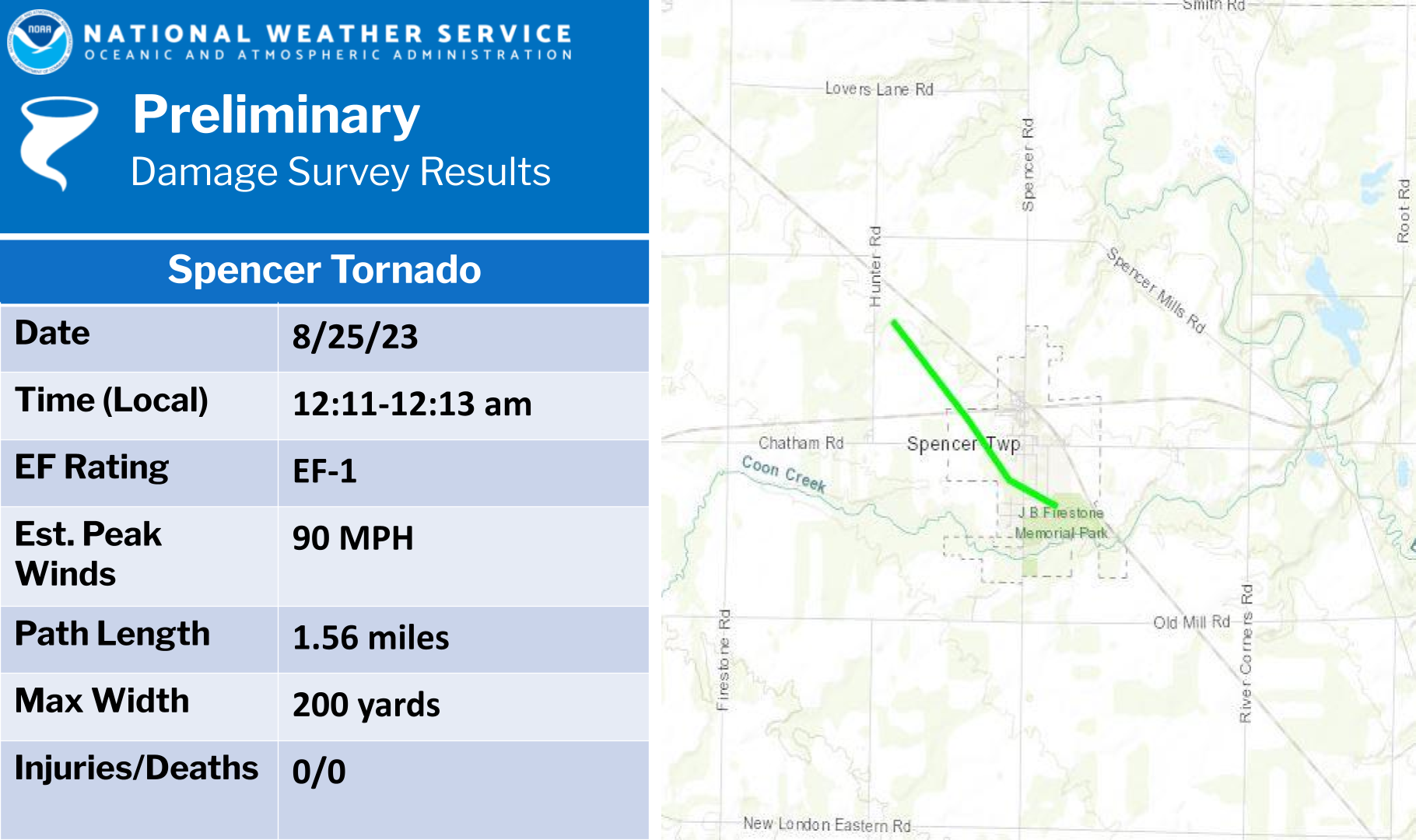
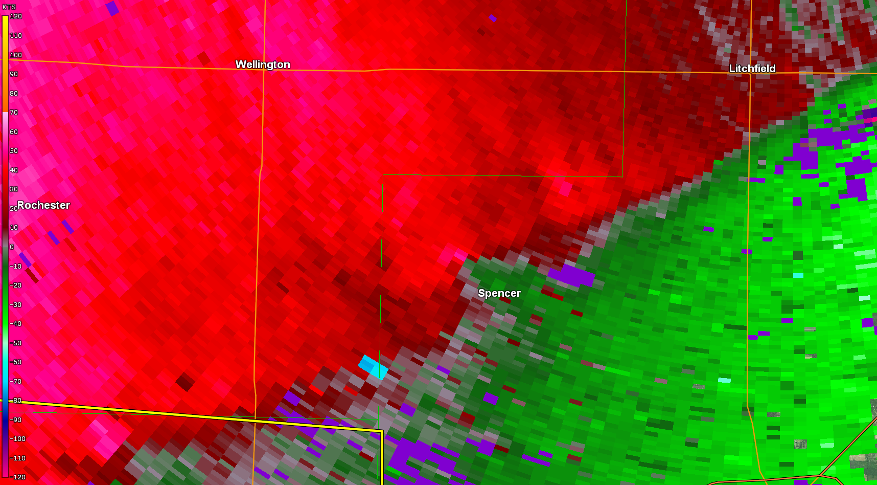
Tornado - Spencer, OH
|
||||||||||||||||
|
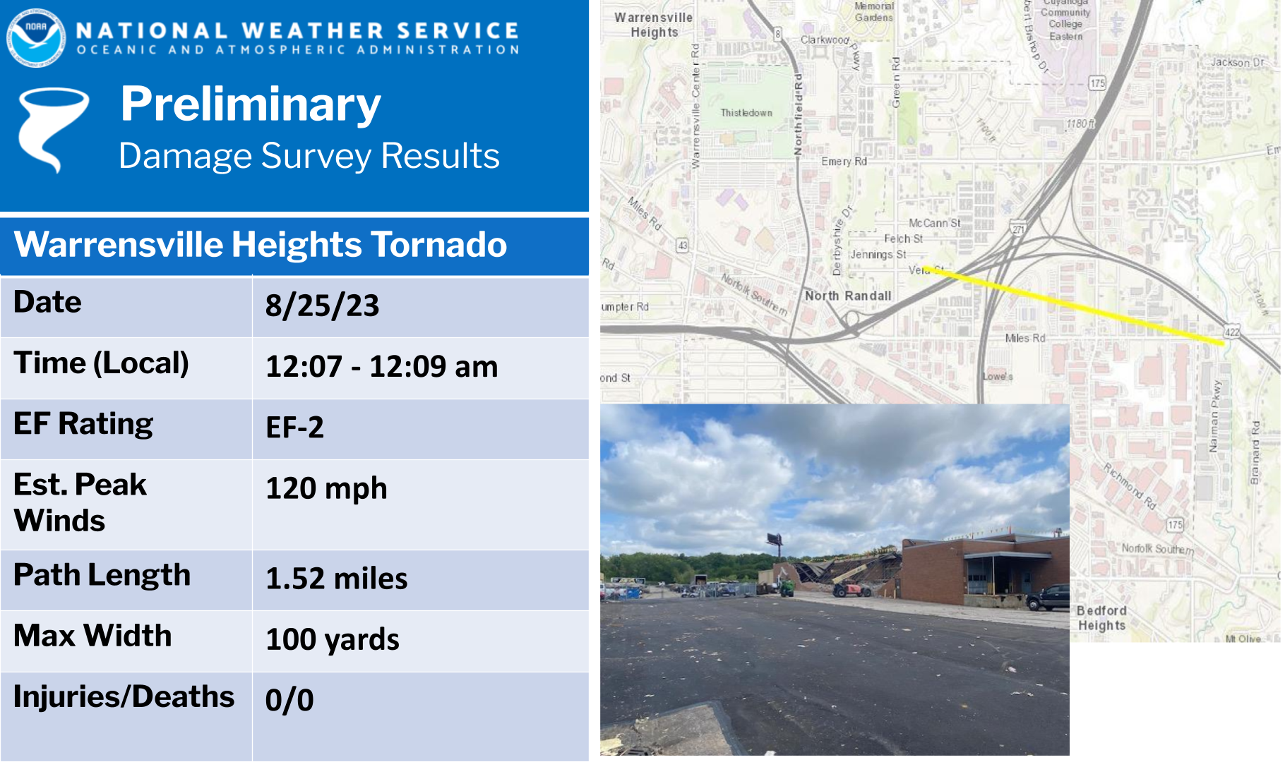
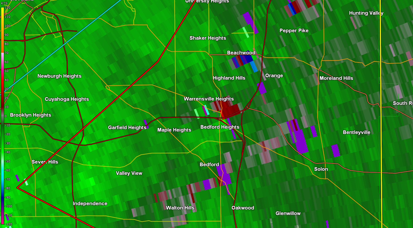
Tornado - Warrensville Heights OH
|
||||||||||||||||
|
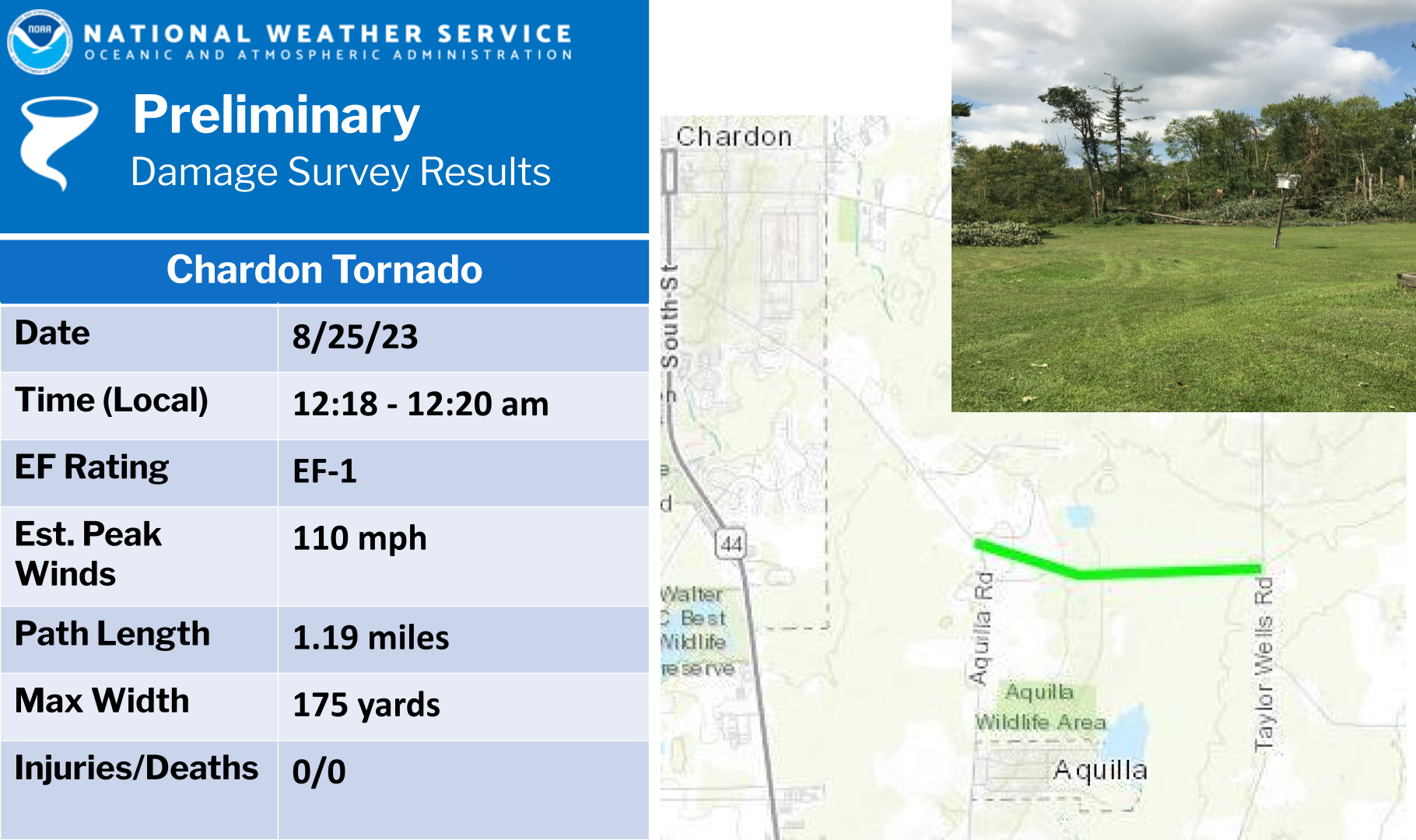
Tornado - Chardon, OH
|
||||||||||||||||
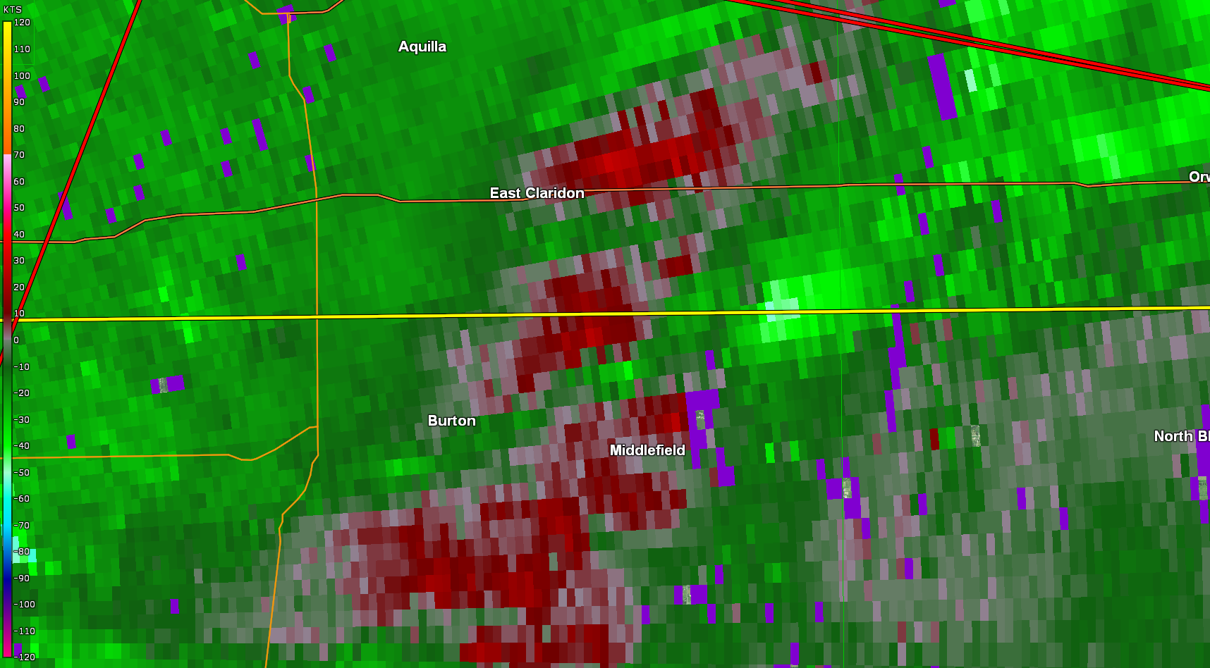
|
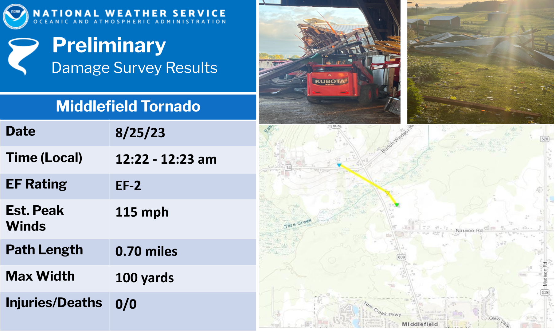
Tornado - Middlefield, OH
|
||||||||||||||||
|
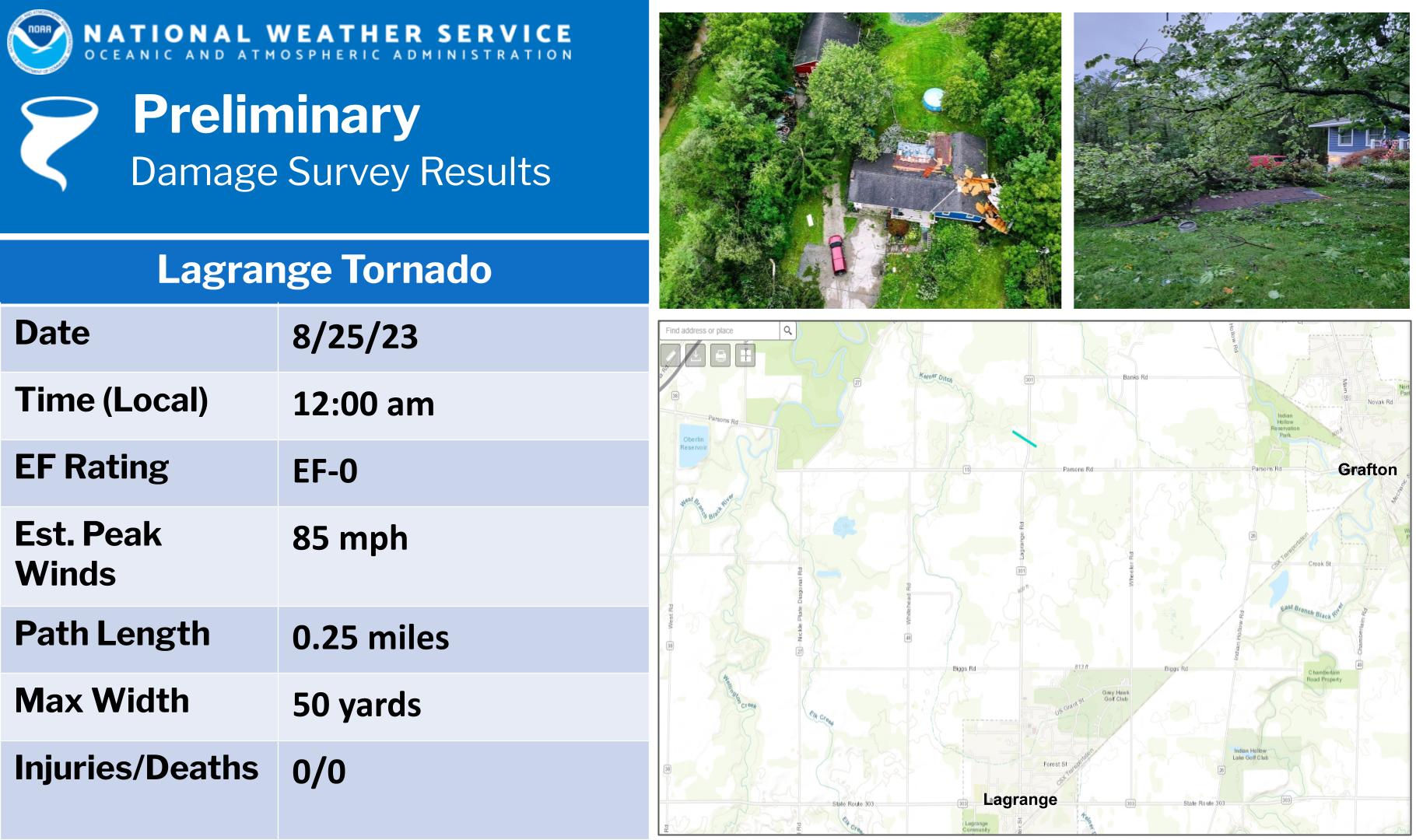
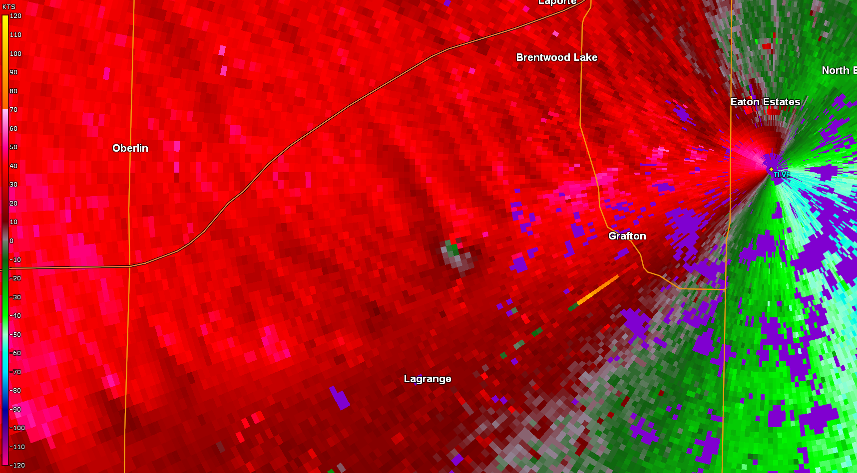
Tornado - Lagrange, OH
|
||||||||||||||||
|
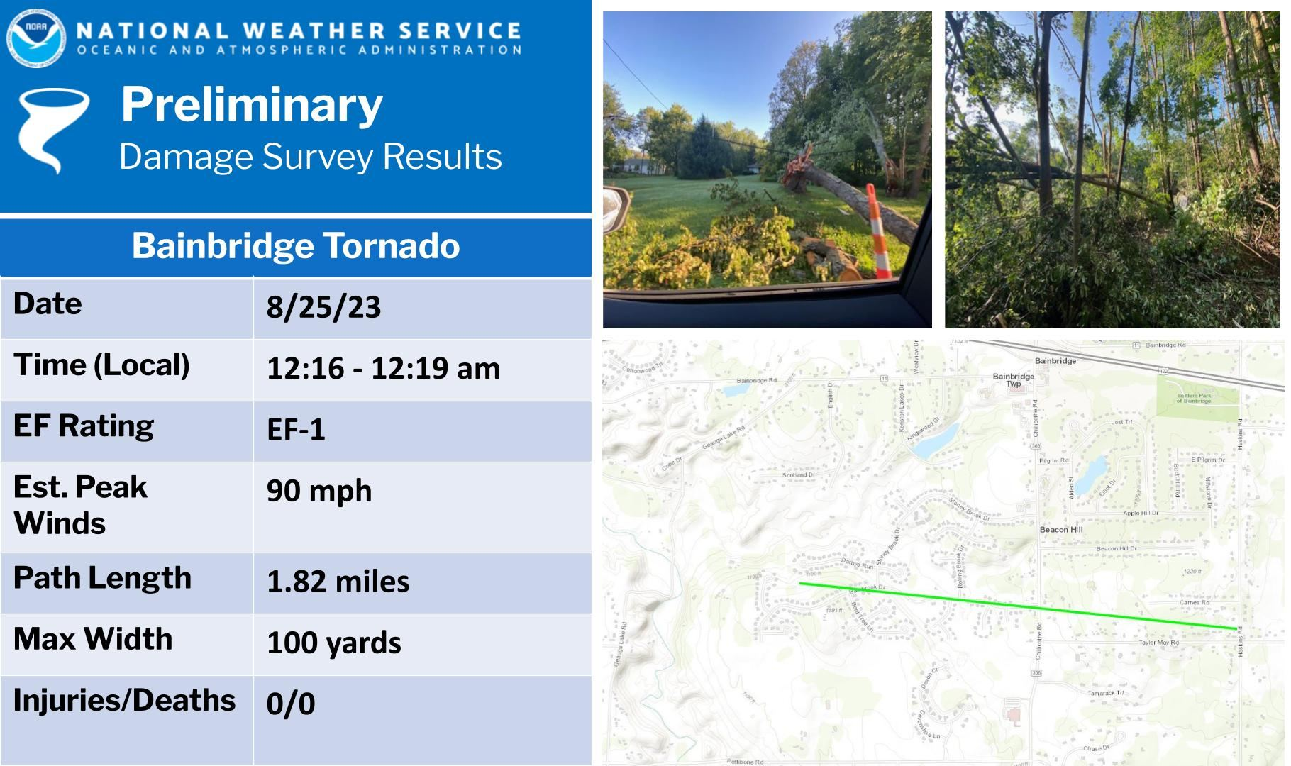
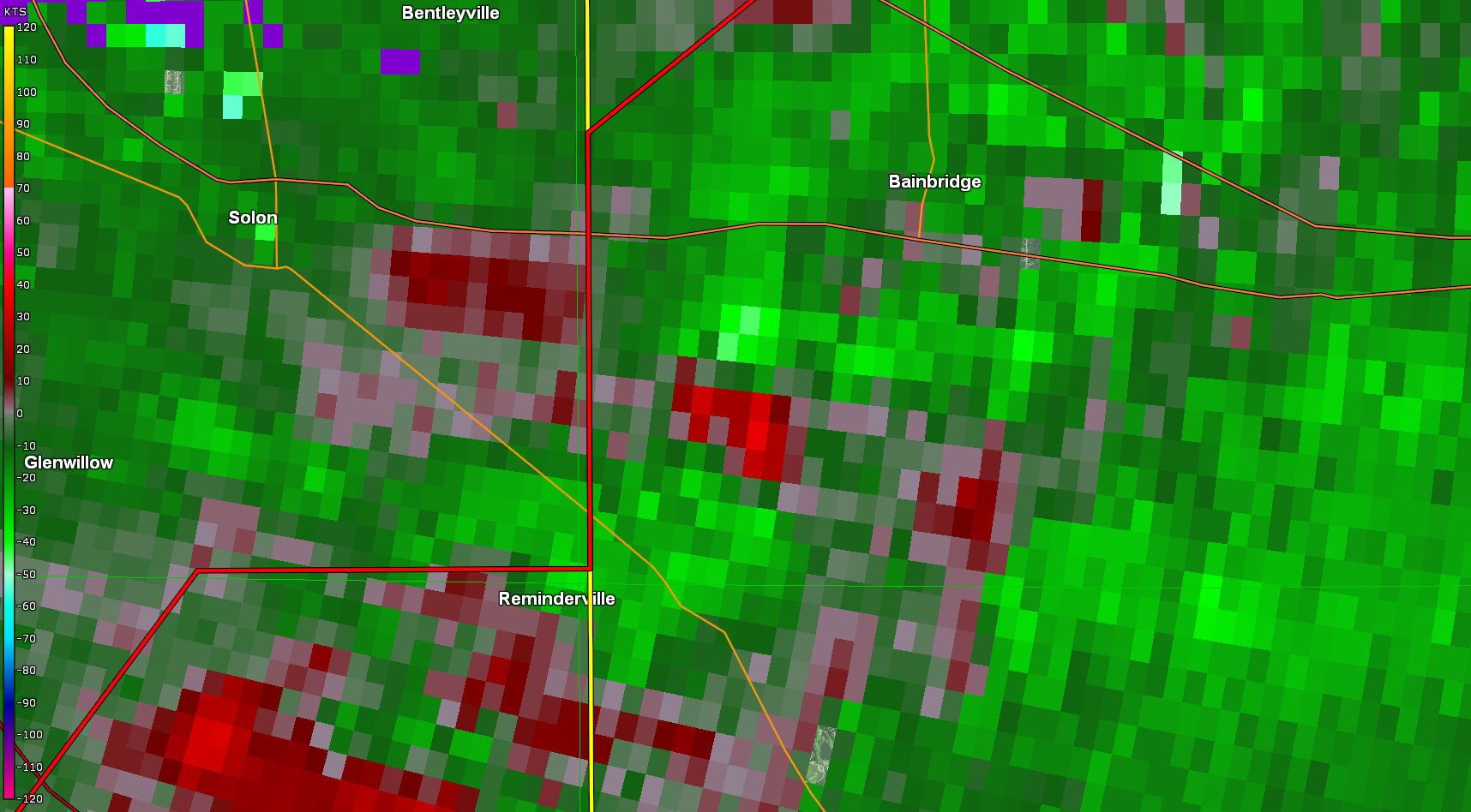
Tornado - Bainbridge, OH
|
||||||||||||||||
|
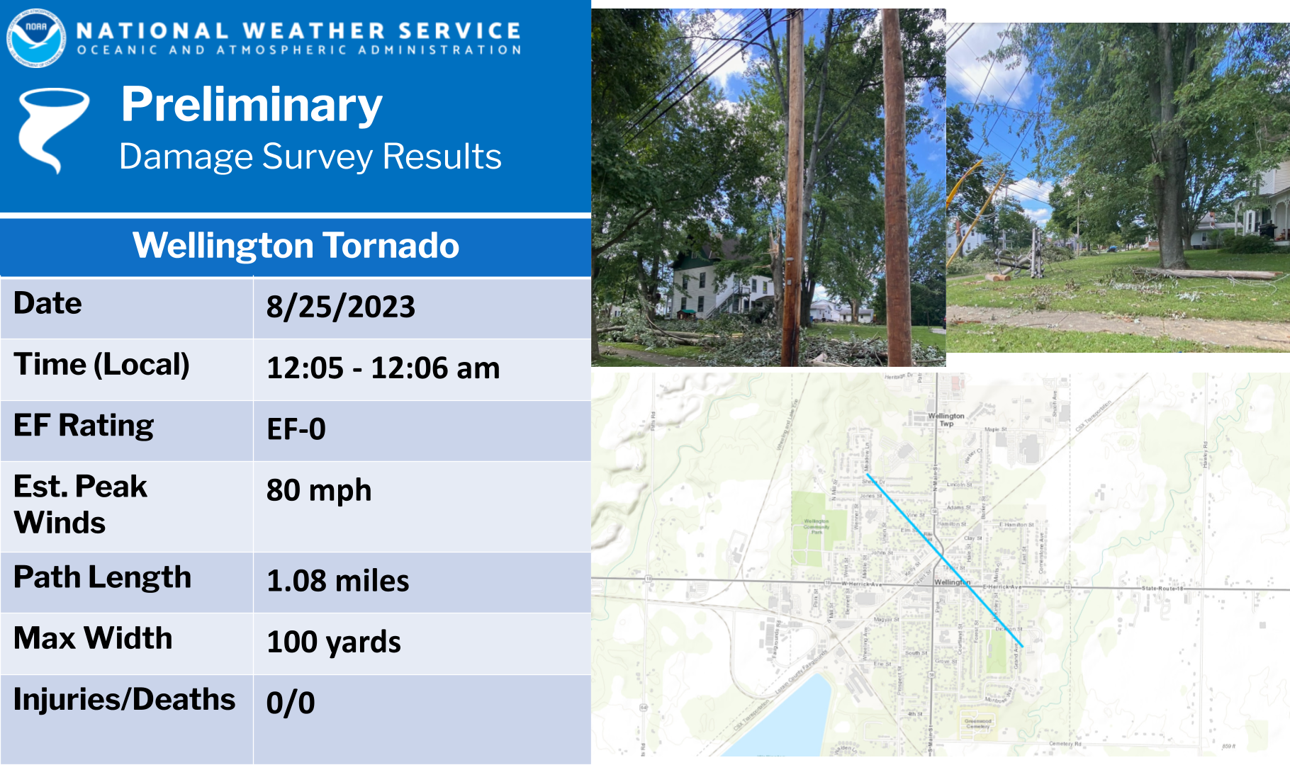
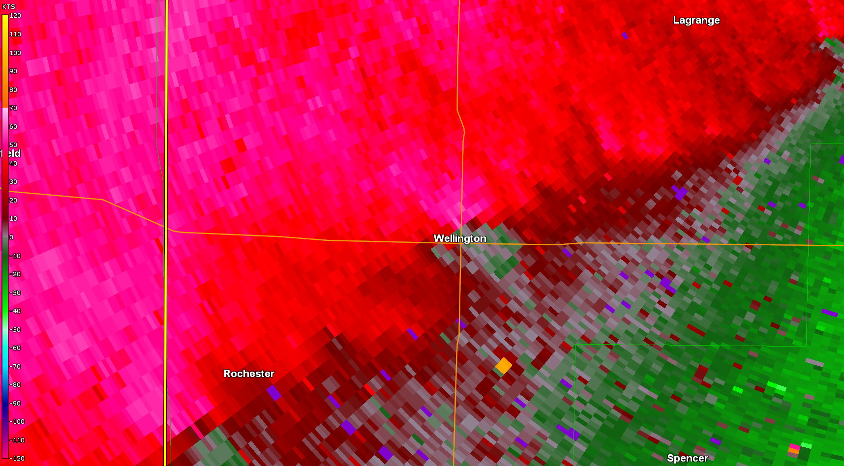
Tornado - Wellington, OH
|
||||||||||||||||
The Enhanced Fujita (EF) Scale classifies tornadoes into the following categories:
| EF0 Weak 65-85 mph |
EF1 Moderate 86-110 mph |
EF2 Significant 111-135 mph |
EF3 Severe 136-165 mph |
EF4 Extreme 166-200 mph |
EF5 Catastrophic 200+ mph |
 |
|||||
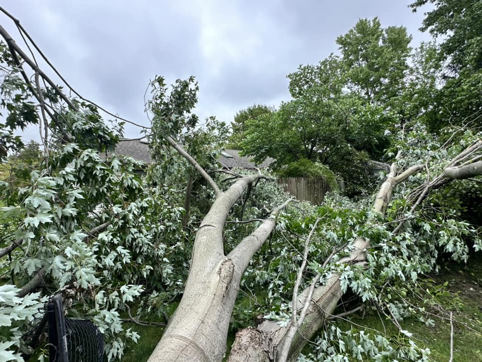
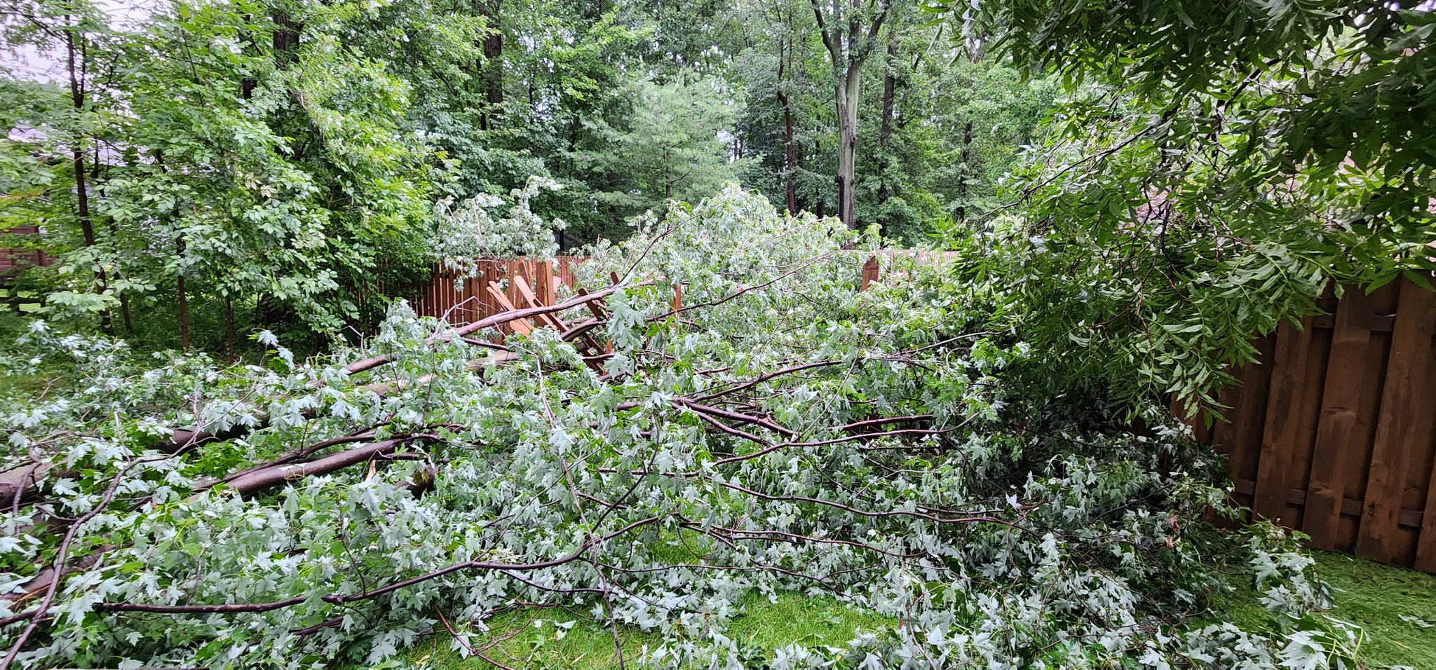
Photos & Video
 |
 |
 |
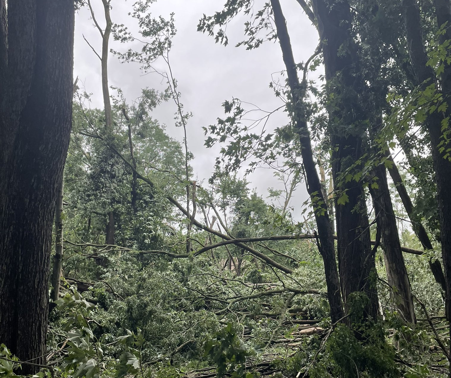 |
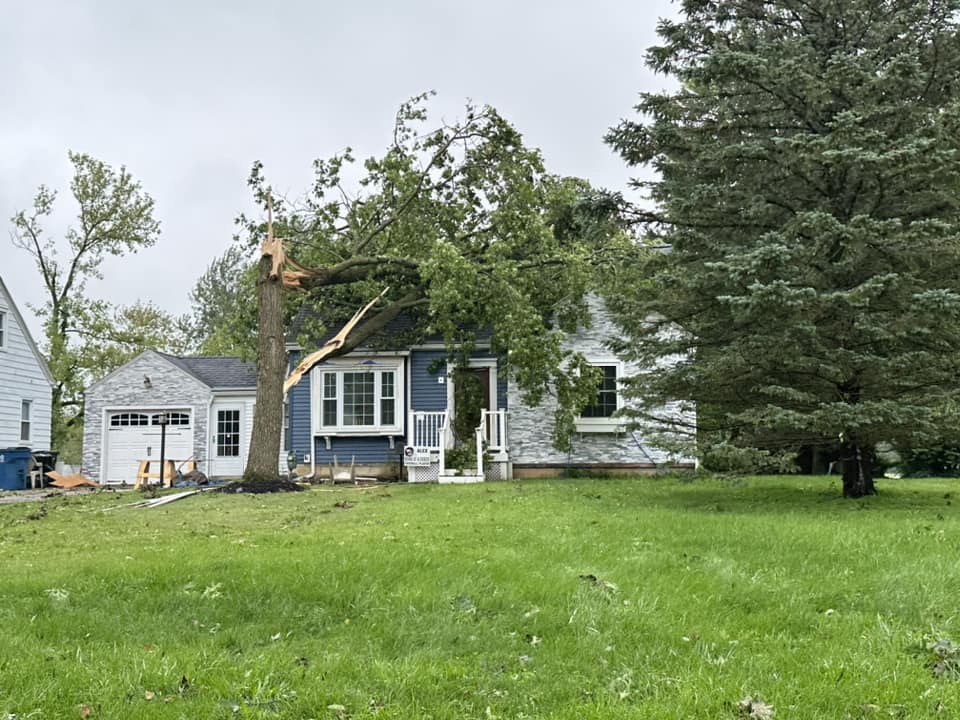
| Tree snapped onto a house in Wellington. Credit: Seth Rowland | Large tree snapped in Eastlake. Credit: Brian Blasius | Large tree downed and damaged a fence in Mentor. Credit: Tom DeMichael | Many trees snapped in Eastlake. Credit: Tyler Schwenk |
 |
 |
 |
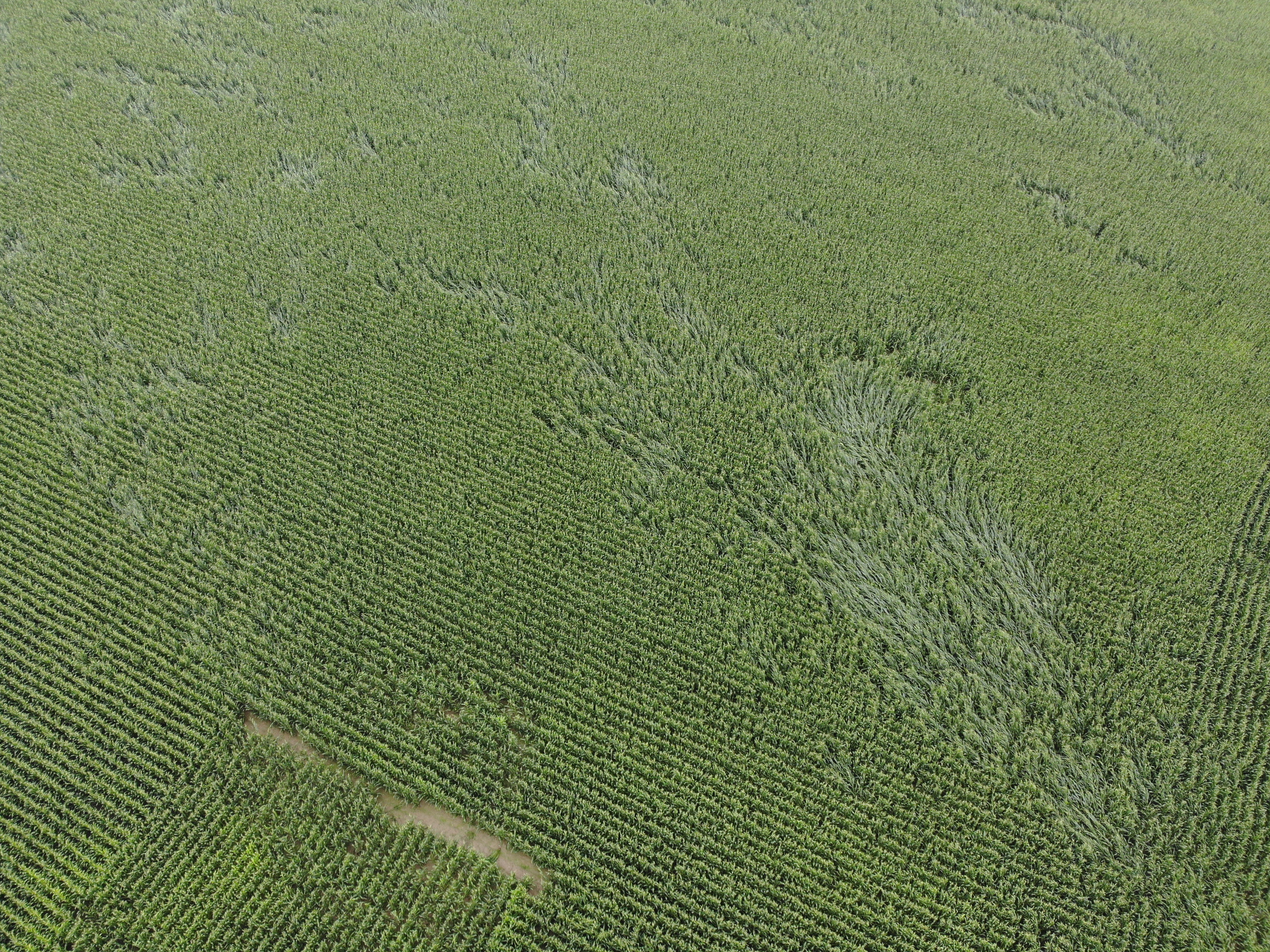 |
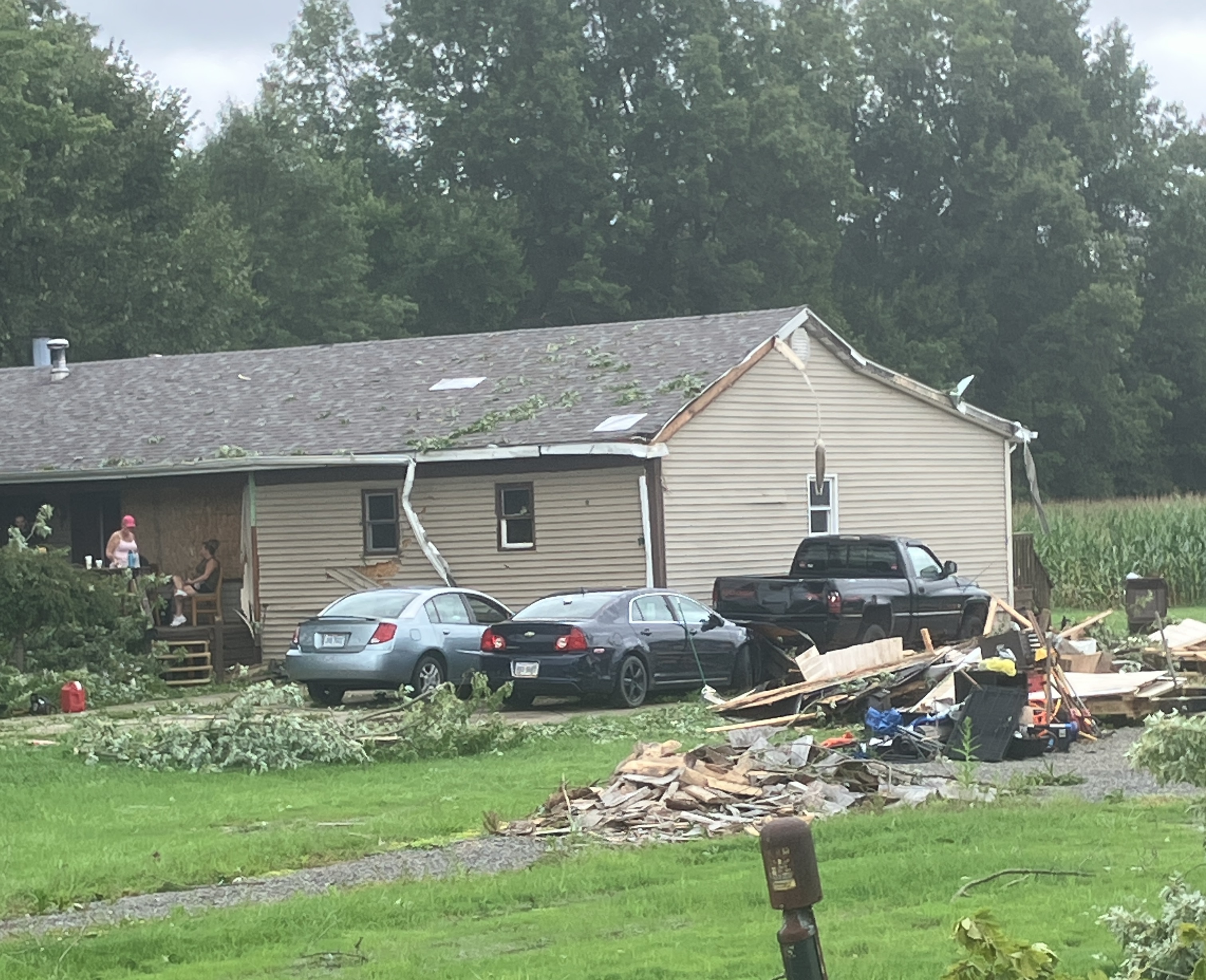
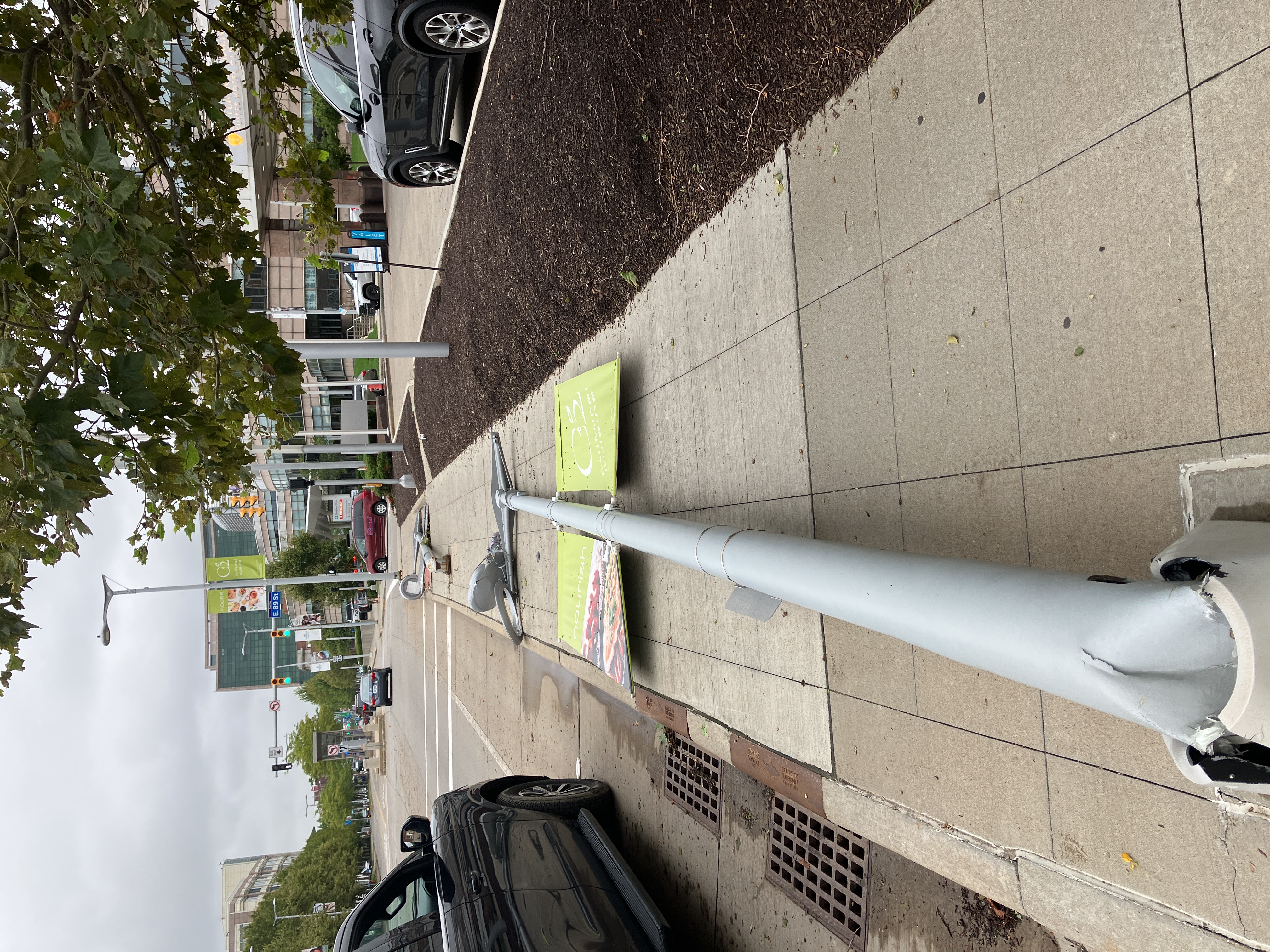
| Damage to a house from the Bristolville, OH EF-0 tornado. | Tree damage from the Mentor, OH EF-1 tornado. | Bent-over light pole from the Cleveland, OH EF-1 tornado. | Swirls in a cornfield from the Spencer, OH EF-1 tornado. |
 |
 |
 |
 |
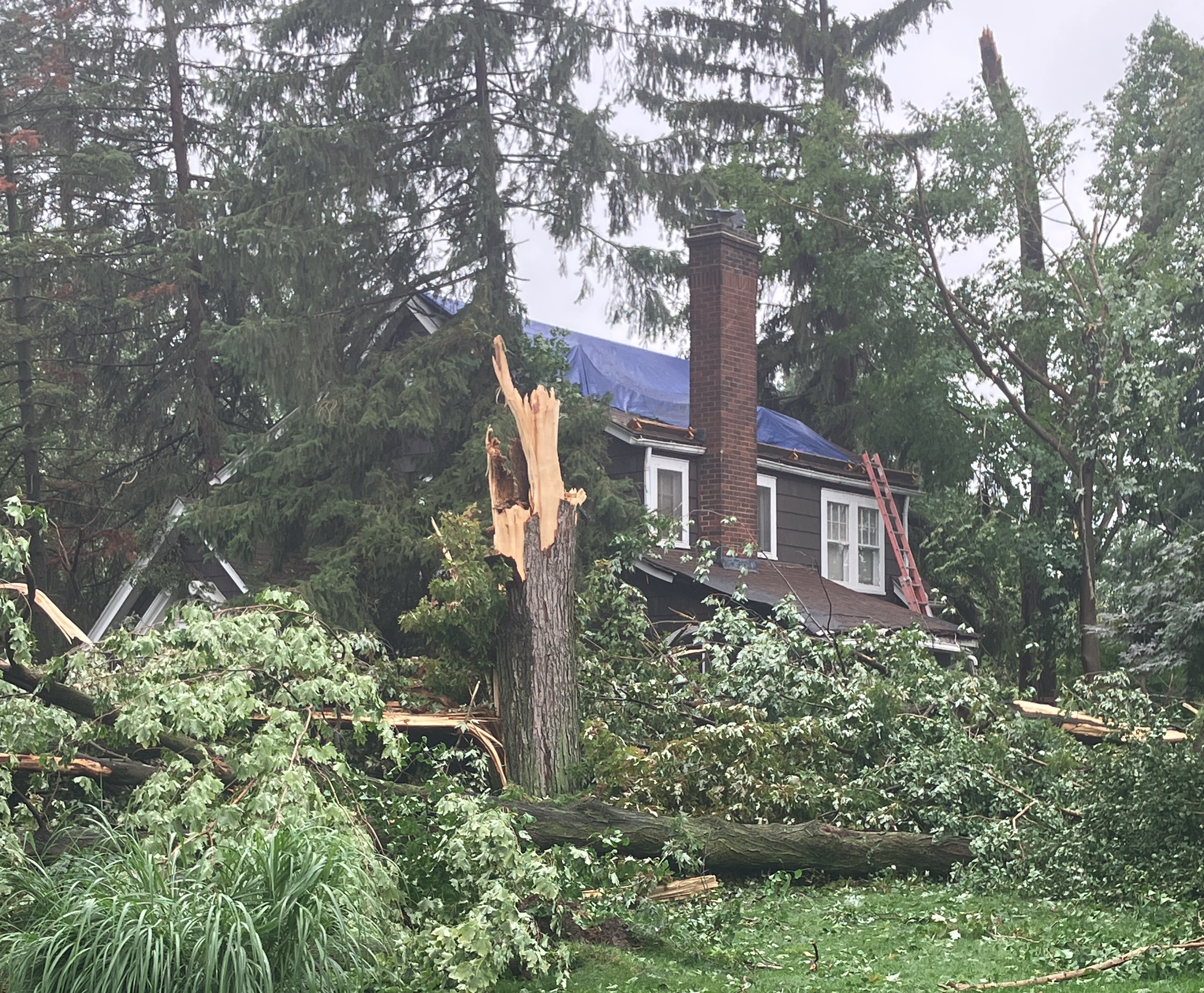
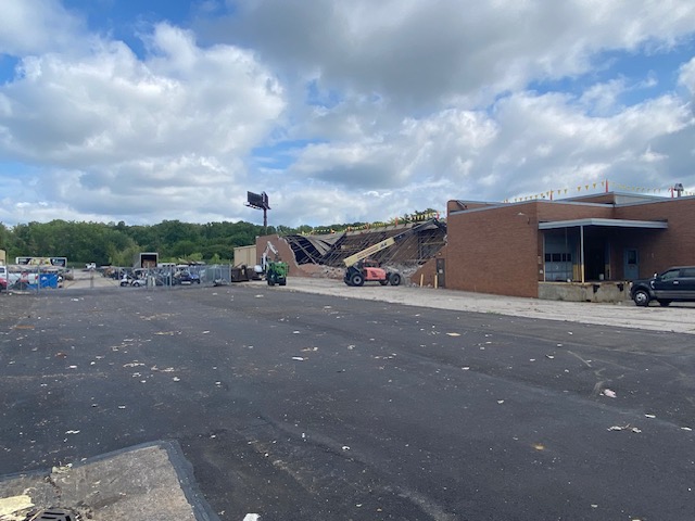
| Extensive damage to a building from the Warrensville Heights, OH EF-2 tornado. | Tree damage from the Chardon, OH EF-1 tornado. | Damage to a barn from the Middlefield, OH EF-2 tornado. | Tree and roof damage from the Lagrange, OH EF-0 tornado. |
 |
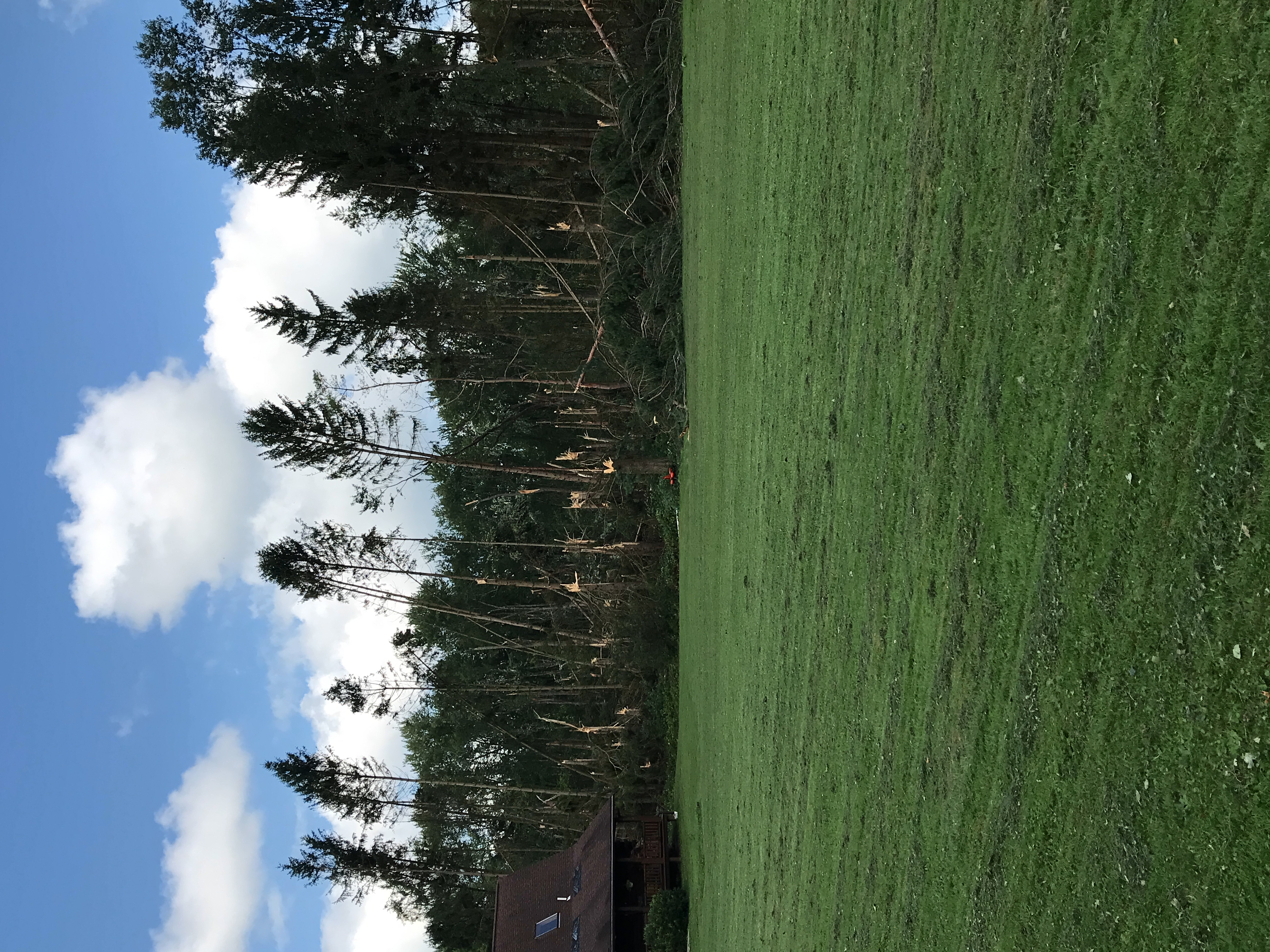
| Tree damage from the Bainbridge, OH EF-1 tornado. |
Radar
 |
| Radar loop with warnings from August 24, 2023 10 PM EDT through August 25, 2023 3 AM EDT. |
 |
 |
 |
 |
Radar velocity image of a small rotation couplet over southern portions of Bainbridge Township in association with an EF-1 tornado. |
Radar velocity image of a small rotation couplet near Bristol Township in association with an EF-0 tornado. |
Radar velocity image of a small rotation couplet just south of Chardon town center in association with an EF-1 tornado. |
Radar velocity image of a small rotation couplet just east of downtown Cleveland in association with an EF-1 tornado. |
 |
 |
 |
 |
Radar velocity image of a small rotation couplet near Elmore in association with an EF-1 tornado. |
Radar velocity image of a small rotation couplet just north of LaGrange in association with an EF-0 tornado. |
Radar velocity image of a small rotation couplet just southwest of downtown Mentor in association with an EF-1 tornado. |
Radar velocity image of a small rotation couplet just northwest of Middlefield Township in association with an EF-2 tornado. |
 |
 |
 |
 |
Radar velocity image of a small rotation couplet just north of Spencer in association with an EF-1 tornado. |
Radar velocity image of a small rotation couplet west of the city of Vermilion in association with an EF-1 tornado. |
Radar velocity image of a small rotation couplet between Warrensville Hts and Bedford Hts in association with an EF-2 tornado. |
Radar velocity image of a small rotation couplet over Wellington in association with an EF-0 tornado. |
Storm Reports
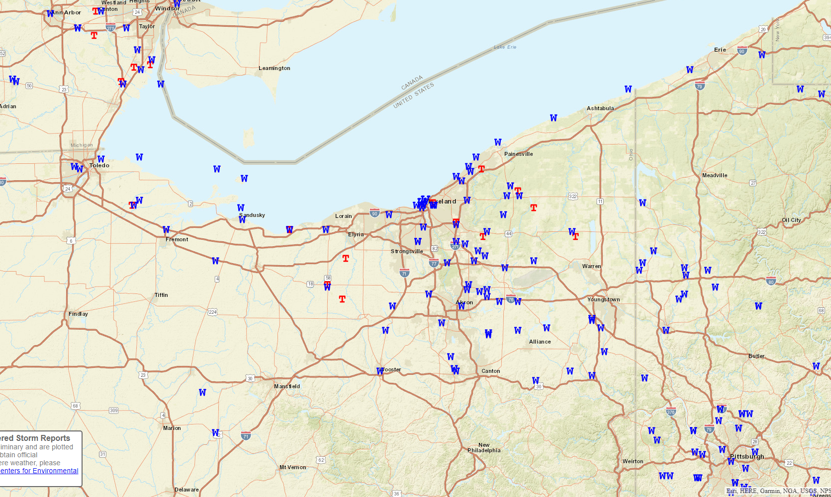
Summary Local Storm Report Link
453
NWUS51 KCLE 291602
LSRCLE
Preliminary Local Storm Report
National Weather Service Cleveland OH
1202 PM EDT Tue Aug 29 2023
..TIME... ...EVENT... ...CITY LOCATION... ...LAT.LON...
..DATE... ....MAG.... ..COUNTY LOCATION..ST.. ...SOURCE....
..REMARKS..
1054 PM Tstm Wnd Gst 1 W Harbor View 41.69N 83.47W
08/24/2023 M58 MPH Lucas OH Buoy
Buoy station THRO1 Toledo, OH.
1058 PM Tstm Wnd Dmg 1 ESE Ottawa Hills 41.66N 83.62W
08/24/2023 Lucas OH Law Enforcement
Power lines blown down on Orchard Road.
1100 PM Tstm Wnd Dmg 1 SSW Toledo 41.65N 83.59W
08/24/2023 Lucas OH Amateur Radio
Large tree limbs blown north of the Toledo
Zoo.
1100 PM Tstm Wnd Gst 4 ENE Harbor View 41.72N 83.37W
08/24/2023 M47 MPH LEZ142 OH Mesonet
Mesonet station 45200 4 NE Oregon.
1108 PM Tornado 2 N Elmore 41.50N 83.30W
08/24/2023 Ottawa OH NWS Storm Survey
An EF1 tornado has been confirmed beginning
near South Nissen Road and West Deno Road
where several tree limbs were broken off.
The tornado continued southeast and damaged
a nursery greenhouse. The tornado crossed
the Portage River and blew down several
trees and scattered broken limbs onto
several homes. The tornado tracked southeast
and uprooted three large trees onto a home
and damaged the roof of this home. The
tornado tracked southeast with max winds of
110 mph where several tree were blown down,
damage to home siding, and snapped power
lines along County Road 92. Max width was
100 yards.
1109 PM Tstm Wnd Dmg 2 N Elmore 41.50N 83.29W
08/24/2023 Ottawa OH Trained Spotter
Several trees snapped and a business sign
damaged north of Elmore. Time estimated via
radar.
1112 PM Tstm Wnd Dmg 3 WSW Rocky Ridge 41.52N 83.26W
08/24/2023 Ottawa OH Amateur Radio
Reports of windows blown out of houses near
Rocky Ridge. Possible tornado.
1125 PM Tstm Wnd Dmg 10 NW Marblehead 41.65N 82.83W
08/24/2023 Ottawa OH Fire Dept/Rescue
Several large trees blown down blocking
roads on Put-in-Bay.
1126 PM Tstm Wnd Dmg 6 NNE Marblehead 41.61N 82.68W
08/24/2023 Erie OH Public
Multiple large trees and large tree limbs
down on Kelleys Island peninsula; trees
blocking only road and down on power lines.
Time estimated via radar.
1130 PM Tstm Wnd Dmg 3 N Fremont 41.40N 83.11W
08/24/2023 Sandusky OH Fire Dept/Rescue
Large tree blown down on to a house.
1130 PM Tstm Wnd Dmg 1 SE Sandusky 41.44N 82.69W
08/24/2023 Erie OH Public
Report from mPING: 3-inch tree limbs broken;
Power poles broken. Time adjusted via radar.
1133 PM Tstm Wnd Gst 2 NNE Sandusky 41.49N 82.70W
08/24/2023 M58 MPH LEZ144 OH Mesonet
Mesonet station XSDB 2 NNE Sandusky.
1135 PM Tstm Wnd Gst 3 W Clyde 41.30N 83.03W
08/24/2023 M48 MPH Sandusky OH AWOS
AWOS station KS24 3 NNE Green Springs.
1138 PM Tstm Wnd Dmg 3 NE Fairview 42.06N 80.22W
08/24/2023 Erie PA Law Enforcement
Tree down on road.
1145 PM Tornado 6 NNE Berlin Heights 41.40N 82.43W
08/24/2023 Erie OH NWS Storm Survey
Corrects previous tornado report from 6 NNE
Berlin Heights. An EF1 tornado has been
confirmed in northeast Erie County OH. The
tornado uprooted trees and broke off large
tree limbs. Several limbs fell onto homes.
One large limb partially destroyed a home
near Mari-Dor Beach Cottages. The tornado
tracked southeast into a rural area and
lifted.
1147 PM Tstm Wnd Dmg 6 W Vermilion 41.40N 82.43W
08/24/2023 Erie OH Trained Spotter
Swath of significant tree damage beginning
on US 6 just west of Poorman Road. Numerous
trees and limbs snapped. Some debris on
roadway.
1148 PM Tstm Wnd Dmg 7 S North East 42.12N 79.82W
08/24/2023 Erie PA Public
Tree down with wires.
1150 PM Tstm Wnd Gst 3 E Huron 41.39N 82.51W
08/24/2023 M47 MPH LEZ144 OH Mesonet
Mesonet station 45203 2 E Huron.
1150 PM Tstm Wnd Gst 3 WNW Vermilion 41.43N 82.36W
08/24/2023 M47 MPH LEZ145 OH Mesonet
Mesonet station XVRM Vermilion.
1152 PM Tstm Wnd Gst 4 N Whitehouse 41.58N 83.80W
08/24/2023 M47 MPH Lucas OH ASOS
ASOS station KTOL Toledo.
1152 PM Tstm Wnd Dmg Amherst 41.40N 82.23W
08/24/2023 Lorain OH Emergency Mngr
*delayed report* Emergency manager reports
significant damage in Amherst. About 20
large trees were downed, with 3 homes
damaged by trees. Several wires down as
well.
1152 PM Tstm Wnd Dmg 2 NW Fairview Park 41.46N 81.88W
08/24/2023 Cuyahoga OH Public
Report of wires down on Clague Road south of
Center Ridge. A tree is also down onto an
occupied vehicle. Report relayed via social
media.
1153 PM Tstm Wnd Gst 1 SSE Walbridge 41.57N 83.48W
08/24/2023 M55 MPH Wood OH ASOS
ASOS station KTDZ Toledo.
1155 PM Tstm Wnd Dmg 4 NNE Corry 41.98N 79.61W
08/24/2023 Erie PA Law Enforcement
Tree down on road.
1158 PM Tstm Wnd Dmg 3 NE Cleveland 41.50N 81.64W
08/24/2023 Cuyahoga OH Broadcast Media
Large tree fell on the Dunham Tavern Museum
causing roof damage.
1158 PM Tstm Wnd Dmg 3 NE Cleveland 41.50N 81.63W
08/24/2023 Cuyahoga OH Broadcast Media
Roof and steeple damage at the New Life at
Calvary Church.
1158 PM Tstm Wnd Gst 3 WNW Cleveland 41.50N 81.73W
08/24/2023 M63 MPH LEZ146 OH Mesonet
Mesonet station XCLE Cleveland - Edgewater.
1159 PM Tstm Wnd Gst Burke Lakefront Airport 41.52N 81.68W
08/24/2023 M75 MPH Cuyahoga OH ASOS
ASOS station KBKL Cleveland reported a 65 kt
wind gust.
1159 PM Tornado 3 NE Cleveland 41.51N 81.64W
08/24/2023 Cuyahoga OH NWS Storm Survey
An EF1 tornado has been confirmed beginning
near East 71st Street and Chester Avenue,
ending near East 89th Street and Euclid
Avenue. Extensive tree damage occurred along
the path with some homes receiving minor
damage. Calvary Church received extensive
roof damage. Multiple light poles were bent
near the base in the shopping center on East
79th Street and at the intersection of East
89th and Euclid Avenue.
1200 AM Tstm Wnd Dmg Eastlake 41.66N 81.44W
08/25/2023 Lake OH Emergency Mngr
Numerous trees down, some on houses across
the area.
1200 AM Tstm Wnd Dmg 2 NNW Cleveland 41.50N 81.69W
08/25/2023 Cuyahoga OH Broadcast Media
*Delayed Report* Several windows were blown
out at the Justice Center and the Old
Courthouse in downtown Cleveland. Numerous
large trees blown down in Huntington Park as
well.
1200 AM Tornado 3 N Lagrange 41.28N 82.12W
08/25/2023 Lorain OH NWS Storm Survey
A brief EF0 has been confirmed 3 miles north
of Lagrange. The tornado caused damage to
the porch and roof of a house, along with
damage to over a dozen trees.
1200 AM Tstm Wnd Dmg 2 NNE Euclid 41.62N 81.51W
08/25/2023 Cuyahoga OH Trained Spotter
Report of numerous trees and wires down on
Edgecliff Dr near E 255th St.
1200 AM Tstm Wnd Gst 1 ENE Huron 41.40N 82.55W
08/25/2023 M47 MPH LEZ144 OH Mesonet
Mesonet station HHLO1 Huron.
1200 AM Tstm Wnd Gst 3 ENE Lakewood 41.50N 81.75W
08/25/2023 M47 MPH LEZ146 OH Mesonet
Mesonet station 45205 3 ENE Lakewood.
1200 AM Tstm Wnd Gst 5 NNE Lakewood 41.55N 81.77W
08/25/2023 M51 MPH LEZ146 OH Mesonet
Mesonet station 45176 4 NNE Lakewood.
1201 AM Tstm Wnd Dmg 1 SW Wickliffe 41.60N 81.48W
08/25/2023 Lake OH Trained Spotter
Trees down on Euclid Avenue near I-90
interchange.
1202 AM Tstm Wnd Dmg 2 WSW Brooklyn Heights 41.41N 81.69W
08/25/2023 Cuyahoga OH Broadcast Media
Numerous trees down and snapped.
1203 AM Tstm Wnd Dmg 2 SW Mentor-on-the-Lake 41.70N 81.40W
08/25/2023 Lake OH Public
Report from mPING: Trees uprooted or
snapped. Time adjusted via radar.
1203 AM Tstm Wnd Dmg 2 SW Mentor-on-the-Lake 41.70N 81.40W
08/25/2023 Lake OH Public
Report from mPING: Trees uprooted or
snapped. Time adjusted via radar.
1204 AM Tornado 2 ENE Willoughby 41.65N 81.37W
08/25/2023 Lake OH NWS Storm Survey
An EF1 tornado has been confirmed in Mentor.
The tornado began just west of Dartmoor Road
near Mentor Avenue where large trees were
downed. The tornado tracked east, downing
numerous large trees. Multiple homes on
Stockbridge Road and Middlesex Road were
damaged when trees fell on them. In
addition, damage to siding and roofs
occurred at multiple homes. Extensive tree
damage continued east across the Great Lakes
Mall property before the tornado shifted
northeast and caused additional tree and
power line damage near the intersection of
Johnnycake Ridge Road and Fairview Avenue.
Further tree damage was observed in Wildwood
Park before the tornado ended just south of
Donald E. Kruger Park.
1205 AM Tstm Wnd Dmg 1 SW Willoughby 41.64N 81.43W
08/25/2023 Lake OH Public
Multiple trees down on SOM Centre Road in
Willoughby. Video from social media.
1205 AM Tstm Wnd Dmg 1 WNW Cleveland 41.49N 81.70W
08/25/2023 Cuyahoga OH Public
One of the coverings on the greenhouses at
Ohio City Farm blew off.
1205 AM Tstm Wnd Dmg 1 SW Willoughby 41.64N 81.43W
08/25/2023 Lake OH Public
Multiple trees down on SOM Centre Road in
Willoughby. Video from social media.
1205 AM Tstm Wnd Dmg Wellington 41.16N 82.22W
08/25/2023 Lorain OH Public
*delayed report* Numerous trees and limbs
down in the Wellington area, along with a
transformer and several power lines down.
1205 AM Tornado 1 N Wellington 41.17N 82.22W
08/25/2023 Lorain OH NWS Storm Survey
A brief EF0 tornado with estimated peak
winds of 80 mph has been confirmed in
Wellington in southwest Lorain County. The
tornado began over the northwest part of
Wellington and dissipated east of Grand
Avenue. The tornado caused tree damage along
a one mile path.
1205 AM Tstm Wnd Dmg 1 WNW Cleveland 41.49N 81.70W
08/25/2023 Cuyahoga OH Public
One of the coverings on the greenhouses at
Ohio City Farm blew off.
1206 AM Tstm Wnd Gst 2 WSW Bratenahl 41.54N 81.64W
08/25/2023 M55 MPH LEZ146 OH Buoy
Buoy station CNDO1 Cleveland, OH.
1207 AM Tstm Wnd Dmg 1 N Bedford Heights 41.42N 81.51W
08/25/2023 Cuyahoga OH Public
Report from mPING: 3-inch tree limbs broken;
Power poles broken. Time adjusted via radar.
1207 AM Tstm Wnd Dmg Mayfield Heights 41.52N 81.45W
08/25/2023 Cuyahoga OH Public
Significant tree damage on Vallevista Dr in
Mayfield Heights. Numerous LARGE trees are
down.
1207 AM Tornado 1 SSE Warrensville Heig 41.43N 81.51W
08/25/2023 Cuyahoga OH NWS Storm Survey
NWS Survey confirms an EF2 tornado in
Warrensville Heights and Bedford Heights.
The tornado downed numerous trees, damaged
several homes, and significantly damaged
several industrial buildings.
1207 AM Tstm Wnd Dmg 1 N Bedford Heights 41.42N 81.51W
08/25/2023 Cuyahoga OH Public
Report from mPING: 3-inch tree limbs broken;
Power poles broken. Time adjusted via radar.
1207 AM Tstm Wnd Dmg Mayfield Heights 41.52N 81.45W
08/25/2023 Cuyahoga OH Public
Significant tree damage on Vallevista Dr in
Mayfield Heights. Numerous LARGE trees are
down.
1210 AM Tstm Wnd Gst 2 NNE Bratenahl 41.59N 81.58W
08/25/2023 M47 MPH LEZ146 OH Mesonet
Mesonet station 45206 2 NNE Bratenahl.
1211 AM Tornado 1 NW Spencer 41.11N 82.14W
08/25/2023 Medina OH NWS Storm Survey
Survey confirms an EF1 tornado with max wind
speeds of 90 mph occurred in Spencer, OH.
Aerial imagery revealed a track of swirls in
corn fields along with uprooted or snapped
trees and minor damage to roof shingles of a
house.
1212 AM Tstm Wnd Gst 1 NNW Fairport Harbor 41.76N 81.28W
08/25/2023 M59 MPH Lake OH Buoy
Buoy station FAIO1 Fairport, OH.
1212 AM Tstm Wnd Dmg 1 ENE Northfield 41.35N 81.51W
08/25/2023 Summit OH Public
Report from mPING: Trees uprooted or
snapped. Time adjusted via radar.
1212 AM Tstm Wnd Gst 1 NNW Fairport Harbor 41.76N 81.28W
08/25/2023 M59 MPH Lake OH Buoy
Buoy station FAIO1 Fairport, OH.
1213 AM Tstm Wnd Dmg 1 NNW Twinsburg 41.34N 81.46W
08/25/2023 Summit OH Law Enforcement
Multiple trees down or snapped off.
1214 AM Tstm Wnd Dmg 1 SSE Reminderville 41.31N 81.39W
08/25/2023 Summit OH NWS Employee
*delayed report* Swath of significant tree
damage from Shepard Rd and 480 in Twinsburg
ESE to Aurora Rd and S Chillicothe Rd. NWS
Employee estimates winds to 80 mph.
1215 AM Tstm Wnd Dmg 1 SE Aquilla 41.54N 81.16W
08/25/2023 Geauga OH Fire Dept/Rescue
*delayed report* Significant tree damage
with a path of numerous snapped trees along
Taylor Wells Rd in Claridon Twp just SE of
Chardon. Pictures from Chardon Fire Dept on
social media.
1215 AM Tstm Wnd Dmg 5 ENE South Russell 41.46N 81.25W
08/25/2023 Geauga OH Public
Trees downed and uprooted in Newbury
Township. Report via social media.
1215 AM Tstm Wnd Dmg 2 N Peninsula 41.26N 81.56W
08/25/2023 Summit OH Public
*delayed report* Numerous trees were blown
down in the Cuyahoga Valley National Park.
Pictures from social media.
1215 AM Tstm Wnd Gst 2 SW Mentor 41.67N 81.37W
08/25/2023 M47 MPH Lake OH AWOS
AWOS station KLNN Willoughby.
1215 AM Tstm Wnd Gst 1 NNE Highland Heights 41.57N 81.47W
08/25/2023 M46 MPH Cuyahoga OH AWOS
AWOS station KCGF Clevlnd Cuyahoga.
1215 AM Tstm Wnd Gst 2 SW Mentor 41.67N 81.37W
08/25/2023 M47 MPH Lake OH AWOS
AWOS station KLNN Willoughby.
1215 AM Tstm Wnd Dmg Chardon 41.58N 81.21W
08/25/2023 Geauga OH Fire Dept/Rescue
Tree fell on house-did make roof collapse
and rain is pouring inside. Trees down on
Wilson Mills & Burlington Ridge (Munson),
and tree into gas line on Britton Rd.
Multiple trees down on Aquilla Rd. Burton
also reporting lots of trees down on Garden.
1216 AM Tornado 2 SW Bainbridge 41.37N 81.36W
08/25/2023 Geauga OH NWS Storm Survey
A brief EF1 tornado with estimated peak
winds of 90 mph has been confirmed in
Bainbridge in southwest Geauga County. The
tornado began over the west part of Laurel
Springs subdivision then dissipated along
Taylor Made Road just west of Haskins Road.
The tornado caused extensive tree damage
along its nearly 2 mile path.
1216 AM Tstm Wnd Dmg Bainbridge 41.39N 81.34W
08/25/2023 Geauga OH Public
*delayed report* Numerous trees down in the
Bainbridge area, along with damage to one
house.
1217 AM Tstm Wnd Dmg 2 S Aurora 41.29N 81.35W
08/25/2023 Portage OH Public
Report from mPING: 3-inch tree limbs broken;
Power poles broken. Time adjusted via radar.
1217 AM Tstm Wnd Gst 4 NNE Conneaut 41.98N 80.56W
08/25/2023 M67 MPH LEZ149 OH Mesonet
Mesonet station XCON Conneaut Light.
1218 AM Tstm Wnd Dmg 3 NE Hudson 41.27N 81.41W
08/25/2023 Summit OH Public
Several trees damaged and downed on
Chamberlain Blvd in Hudson.
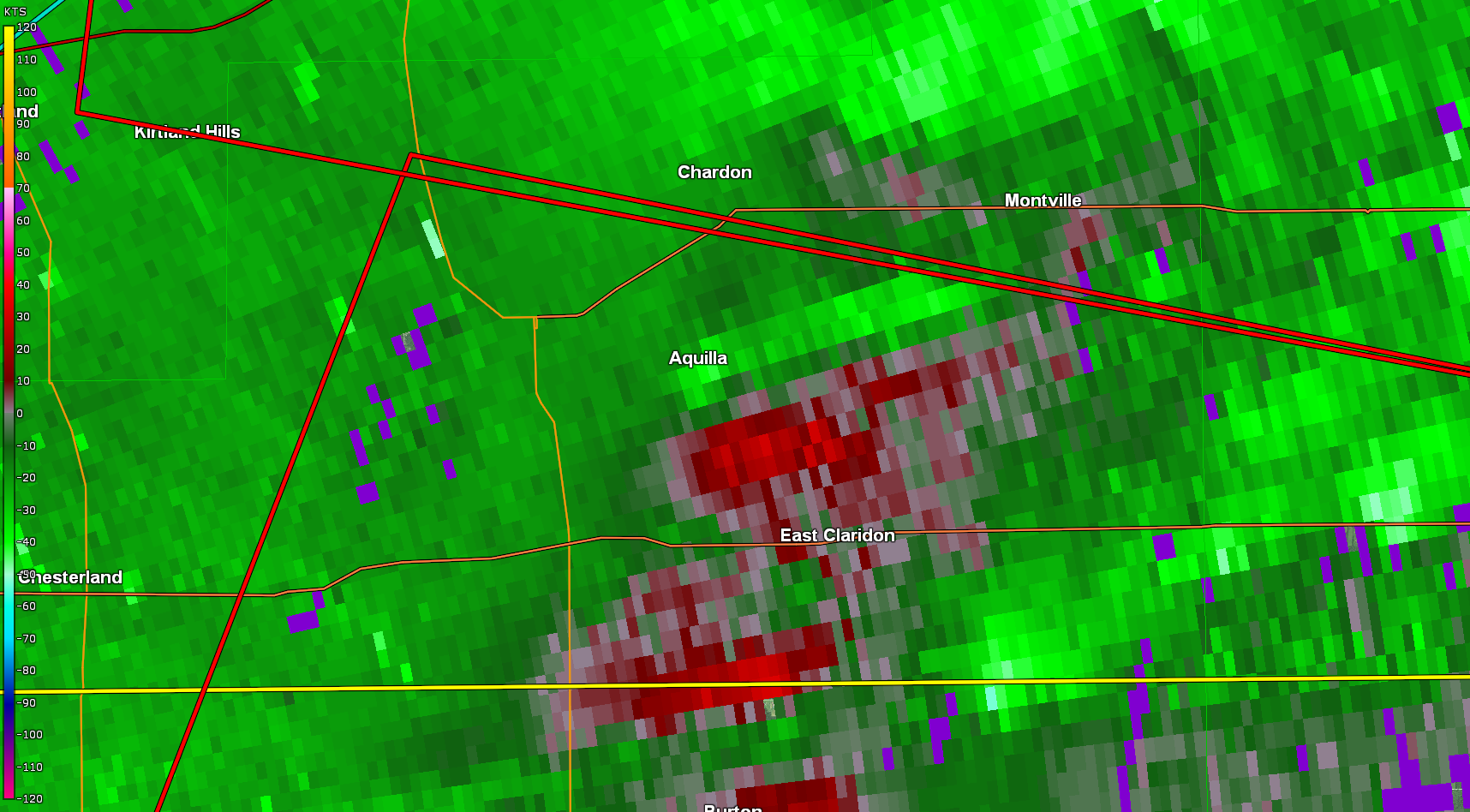
1218 AM Tornado 1 N Aquilla 41.56N 81.17W
08/25/2023 Geauga OH NWS Storm Survey
An EF-1 tornado has been confirmed southeast
of Chardon. The tornado began near the
intersection of Aquilla Road and Tewksbury
Lane where it caused significant damage to
trees and power lines before tracking
southeast through the Meadow Wood Drive
cul-de-sac. Extensive damage to trees,
including numerous snapped and uprooted
trees, occurred. From the end of Meadow Wood
Drive, the tornado tracked due east,
significantly impacted a property on the
west side of Taylor Wells Road. Here, a
swath of trees was snapped and uprooted
across the property. The tornado lifted on
the east side of Taylor Wells Road where
additional tree damage was observed.
1220 AM Tstm Wnd Dmg 3 SSW Chardon 41.54N 81.23W
08/25/2023 Geauga OH Fire Dept/Rescue
Tree down on house with Structural Damage -
Mutual Aid to Munson along Meadowhurst Road.
Large amount of debris on Auburn Rd.
1221 AM Tstm Wnd Dmg 2 ENE Briarwood Beach 41.08N 81.86W
08/25/2023 Medina OH Public
Report from mPING: 3-inch tree limbs broken;
Power poles broken. Time adjusted via radar.
1221 AM Tstm Wnd Dmg 2 NNE Pigeon Creek 41.13N 81.66W
08/25/2023 Summit OH Public
Report of trees and limbs down on Heritage
Woods Drive in Copley. Report via social
media.
1222 AM Tornado 2 N Middlefield 41.49N 81.08W
08/25/2023 Geauga OH NWS Storm Survey
An EF-2 tornado has been confirmed in
Middlefield. The tornado began near the
intersection of Burton-Windsor Road and
Route 608 where it caused minor damage to
trees. It tracked southeast, quickly
intensifying before it completely destroyed
a barn and causing extensive damage to the
property. The entire barn was lofted and
thrown approximately 150 yards due southeast
and the entire outer structure composed of
cinder blocks collapsed. Adjacent barns
received extensive damage as well. From this
location, the tornado traveled
south-southeast before lifting near the
intersection of Route 608 and Nauvoo Road.
Additional trees damage was located on that
property.
1222 AM Tstm Wnd Dmg Stow 41.17N 81.44W
08/25/2023 Summit OH Trained Spotter
Tree downed across state route 91 at Stow
Road in Stow. Time estimated via radar.
1223 AM Tstm Wnd Dmg 3 SSW Mantua 41.24N 81.24W
08/25/2023 Portage OH Public
Several trees down and displaced property at
a residence on State Route 303 west of State
Route 44.
1225 AM Tstm Wnd Dmg Silver Lake 41.15N 81.45W
08/25/2023 Summit OH Public
*Delayed Report* Significant tree damage
along Graham Road near Country Club Road in
Silver Lake. Pictures from social media.
1226 AM Tstm Wnd Dmg 1 ESE Garrettsville 41.27N 81.08W
08/25/2023 Portage OH Public
Tree down in front of Homestead Manor
Trailer Park.
1227 AM Tstm Wnd Dmg 2 E Akron 41.08N 81.48W
08/25/2023 Summit OH Public
Tree down on a car in Goodyear Heights in
Akron. Report via social media.
1227 AM Tstm Wnd Dmg 2 NNE Brimfield 41.12N 81.34W
08/25/2023 Portage OH Public
Six large trees down near State Route 43 and
I-76. Additional limbs and branches were
also reported down.
1227 AM Tstm Wnd Dmg 2 E Akron 41.08N 81.48W
08/25/2023 Summit OH Public
Tree down on a car in Goodyear Heights in
Akron. Report via social media.
1228 AM Tstm Wnd Dmg 1 E Kent 41.15N 81.34W
08/25/2023 Portage OH Public
*Delayed Report* Significant tree damage and
power lines down around Kent University.
Pictures from social media.
1228 AM Tstm Wnd Dmg Creston 40.98N 81.90W
08/25/2023 Wayne OH Storm Chaser
Report from Spotter Network of multiple
limbs up to 6 inches in diameter downed
along route 3 in Creston. Time estimated via
radar.
1228 AM Tstm Wnd Dmg 1 SW Kent 41.14N 81.38W
08/25/2023 Portage OH Trained Spotter
Spotter 1.5 miles SW of Kent reported
numerous trees and limbs snapped, power out,
and a measured 80 MPH gust on a backyard
weather station.
1230 AM Tstm Wnd Gst 2 W Geneva-on-the-Lake 41.86N 80.97W
08/25/2023 M59 MPH LEZ147 OH Mesonet
Mesonet station GELO1 1 W
Geneva-on-the-Lake.
1231 AM Tstm Wnd Dmg 1 E Barberton 41.01N 81.59W
08/25/2023 Summit OH Local Official
Multiple tress and limbs down in Tuscora
Park.
1232 AM Tstm Wnd Dmg 5 E West Farmington 41.39N 80.87W
08/25/2023 Trumbull OH Emergency Mngr
Damage to a property, including the collapse
of a car port and damage to a roof.
1234 AM Tstm Wnd Dmg 4 E Brimfield 41.10N 81.27W
08/25/2023 Portage OH Public
*delayed report* Several trees snapped on
Tallmadge Rd between Biltz Rd. and Kline Rd.
Power lines also downed.
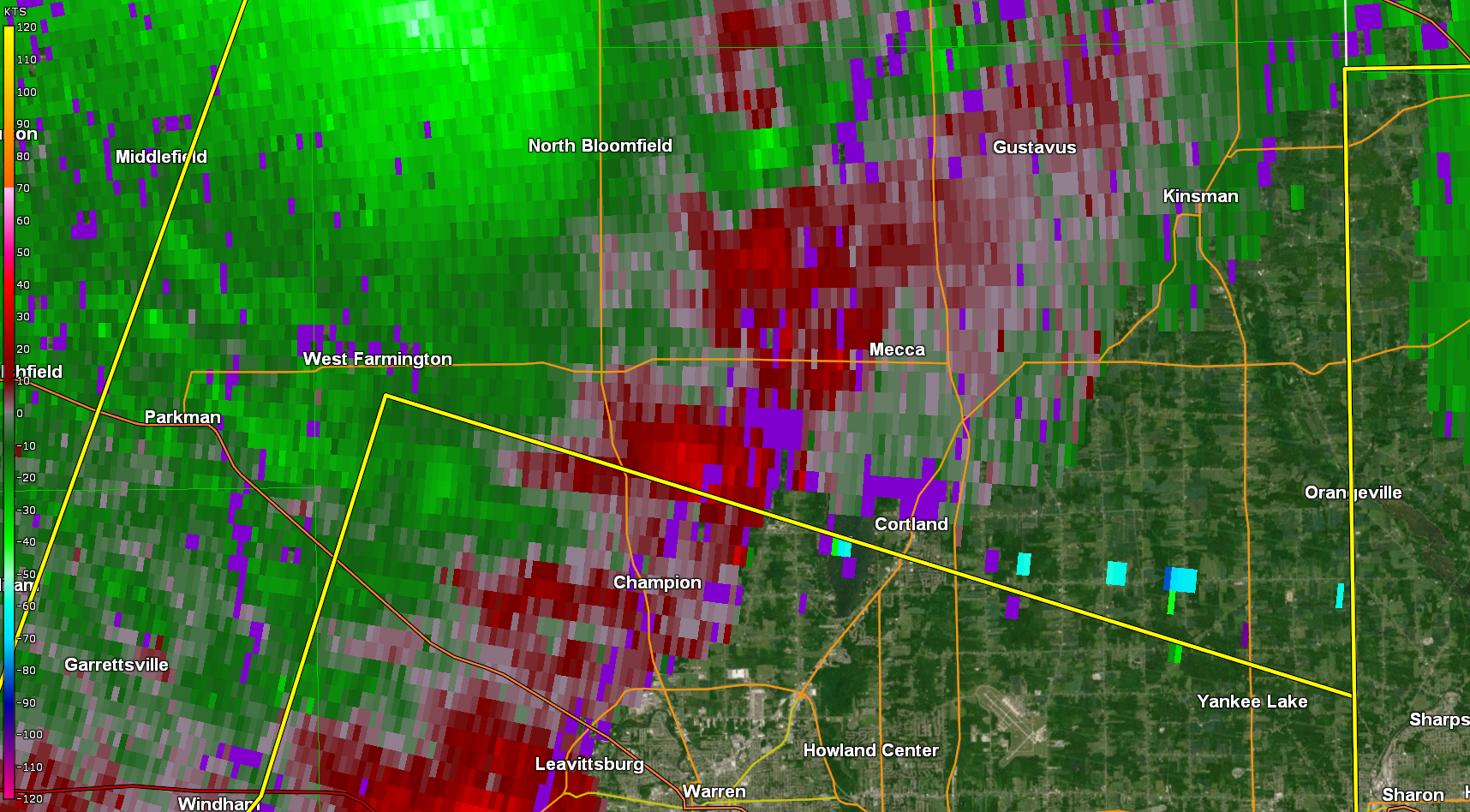
1235 AM Tornado 6 N Champion Heights 41.37N 80.85W
08/25/2023 Trumbull OH NWS Storm Survey
An EF-0 tornado has been confirmed in
Bristolville beginning just east of
Mahan Denman Road on Hyde Shaffer Road
where large tree branches were snapped.
The tornado traveled east, damaging
corn fields and additional trees before
crossing Thompson Clark Road. North of
the intersection of Thompson Clark Road
and Hyde Shaffer Road, multiple homes
sustained minor damage to siding,
shingles, and roofing and one home had
the car port collapse. The tornado
continued east, paralleling Hyde Shaffer
Road before ending near North Park Avenue.
1236 AM Tstm Wnd Dmg 6 SE Ravenna 41.10N 81.17W
08/25/2023 Portage OH Public
*delayed report* Numerous trees snapped near
Stroup Rd and County Highway 18 in Edinburg
Township. One tree fell on a barn.
1239 AM Tstm Wnd Dmg Wooster 40.81N 81.93W
08/25/2023 Wayne OH Public
Tree reported downed on a house in Wooster.
Time estimated via radar.
1240 AM Tstm Wnd Dmg 1 NE Hartville 40.97N 81.33W
08/25/2023 Stark OH Storm Chaser
Report from spotter network...multiple large
trees and power lines down in Hartville,
especially along N Prospect Ave. Time
estimated via radar.
1240 AM Tstm Wnd Dmg Hartville 40.96N 81.33W
08/25/2023 Stark OH Public
*Delayed Report* Detached multi-car
apartment garage was destroyed. Pictures
from social media.
1244 AM Tstm Wnd Dmg 2 ESE Canal Fulton 40.87N 81.54W
08/25/2023 Stark OH Public
Trees and power lines down on Scattell St
NW, Elmvale St NW, Mapleview St NW, and
Persimmon St NW.
1244 AM Tstm Wnd Dmg 1 WSW Limaville 40.98N 81.17W
08/25/2023 Stark OH Public
Several trees snapped and uprooted and
damage to a barn off McCallum Ave NE north
of Price St NE.
1245 AM Tstm Wnd Gst 1 NNE Uniontown 40.99N 81.40W
08/25/2023 M53 MPH Summit OH Mesonet
Mesonet station EW0182 Uniontown.
1245 AM Tstm Wnd Dmg 5 N Sebring 40.99N 81.01W
08/25/2023 Portage OH Public
*delayed report* Numerous trees are uprooted
and snapped near Berlin Lake and in North
Benton. There was also hail damage to cars.
1245 AM Tstm Wnd Gst 1 NNE Uniontown 40.99N 81.40W
08/25/2023 M53 MPH Stark OH Mesonet
Mesonet station EW0182 Uniontown.
1246 AM Tstm Wnd Dmg 10 SSW Linesville 41.51N 80.48W
08/25/2023 Crawford PA Law Enforcement
Multiple trees down across the area.
1248 AM Tstm Wnd Dmg 2 N Massillon 40.82N 81.52W
08/25/2023 Stark OH Trained Spotter
Tree down, partially on a house.
1250 AM Tstm Wnd Dmg 2 NNE Massillon 40.81N 81.51W
08/25/2023 Stark OH Trained Spotter
Tree on house.
1251 AM Tstm Wnd Gst 1 ESE Vienna 41.25N 80.67W
08/25/2023 M54 MPH Trumbull OH ASOS
ASOS station KYNG Youngstown.
1251 AM Tstm Wnd Gst 2 SSW Green 40.92N 81.45W
08/25/2023 M49 MPH Summit OH ASOS
ASOS station KCAK Akron-Canton Regional
Arpt.
1251 AM Tstm Wnd Gst 1 ESE Vienna 41.25N 80.67W
08/25/2023 M54 MPH Trumbull OH ASOS
ASOS station KYNG Youngstown.
1251 AM Tstm Wnd Gst 2 NW Brook Park 41.42N 81.85W
08/25/2023 M53 MPH Cuyahoga OH ASOS
ASOS station KCLE Cleveland.
1253 AM Tstm Wnd Gst 3 E South Amherst 41.35N 82.18W
08/25/2023 M47 MPH Lorain OH ASOS
ASOS station KLPR Lorain Elyria.
1253 AM Tstm Wnd Gst 5 NE Jefferson 41.78N 80.70W
08/25/2023 M47 MPH Ashtabula OH ASOS
ASOS station KHZY Ashtabula.
1255 AM Tstm Wnd Dmg Canfield 41.03N 80.76W
08/25/2023 Mahoning OH Public
Several trees blown down on S Broad Street
and Fair Street in Canfield. Also a power
line is down on Fairground Boulevard.
1259 AM Tstm Wnd Dmg 4 SSW Boardman 40.99N 80.71W
08/25/2023 Mahoning OH Public
Numerous pine tree tops and large branches
broken on New Buffalo Road just south of
Western Reserve Road.
1259 AM Tstm Wnd Dmg 1 SE Canfield 41.02N 80.76W
08/25/2023 Mahoning OH Broadcast Media
Numerous trees and power lines down. One
tree on a house.
0242 AM Tstm Wnd Dmg 6 SSW North Robinson 40.72N 82.91W
08/25/2023 Crawford OH Public
Tree down on road.
0300 AM Tstm Wnd Dmg Mount Gilead 40.55N 82.84W
08/25/2023 Morrow OH Emergency Mngr
*delayed report* Several large tree limbs
caused power outages in Mt Gilead. There was
also a utility pole that was snapped at the
base on the county courthouse campus.
Several roads also had high water.
&&
$$
Environment
 |
 |
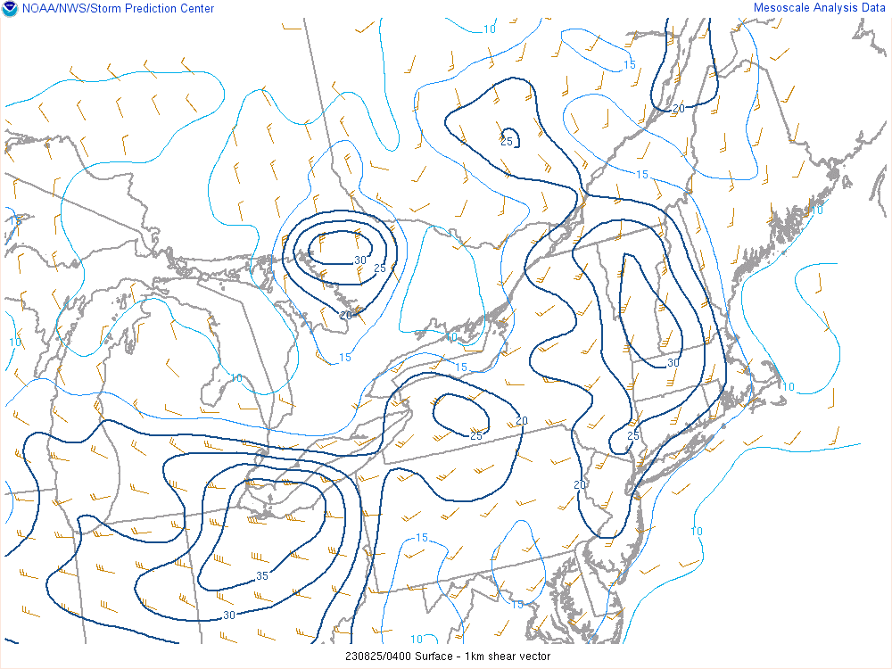 |
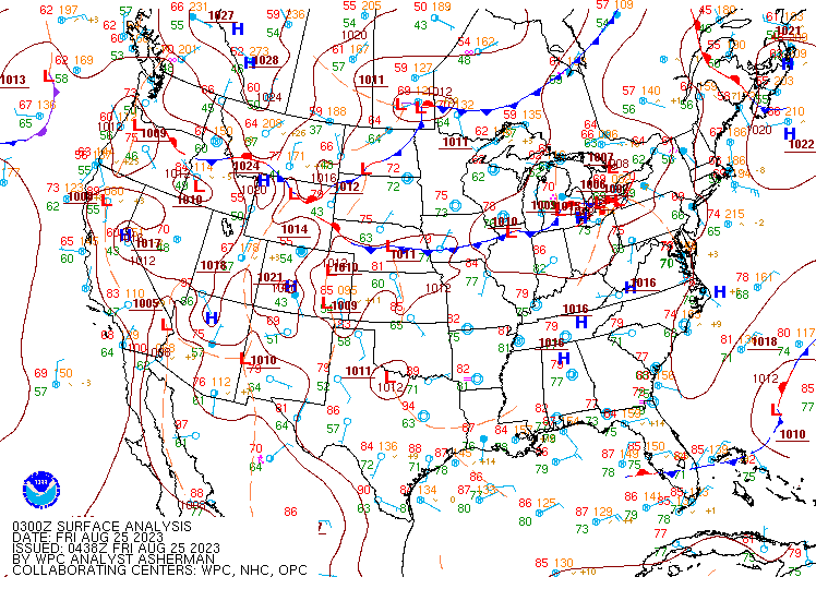
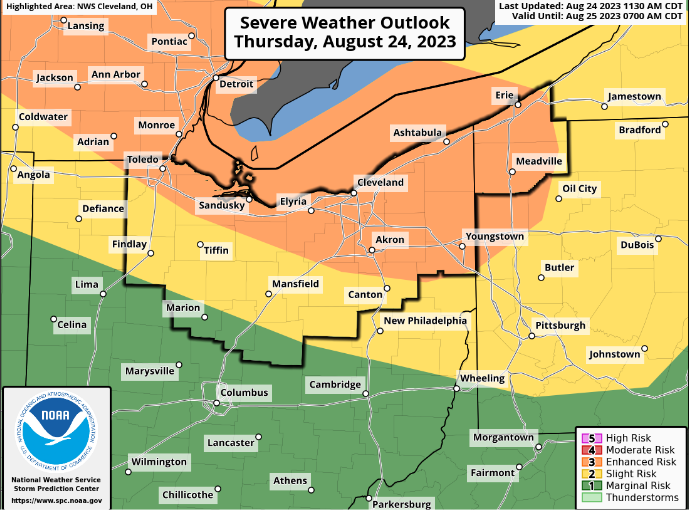
| Figure 1: WPC surface analysis at midnight on August 25, 2023. | Figure 2: SPC day 1 outlook, highlighting portions of the Lower Great Lakes in an Enhanced Risk (level 3 out of 5) for severe storms. | Figure 3: Low-level shear (0-1 km) across the Lower Great Lakes at midnight on August 25, 2023. Note strong low-level shear exceeding 30 knots. |
 |
 |
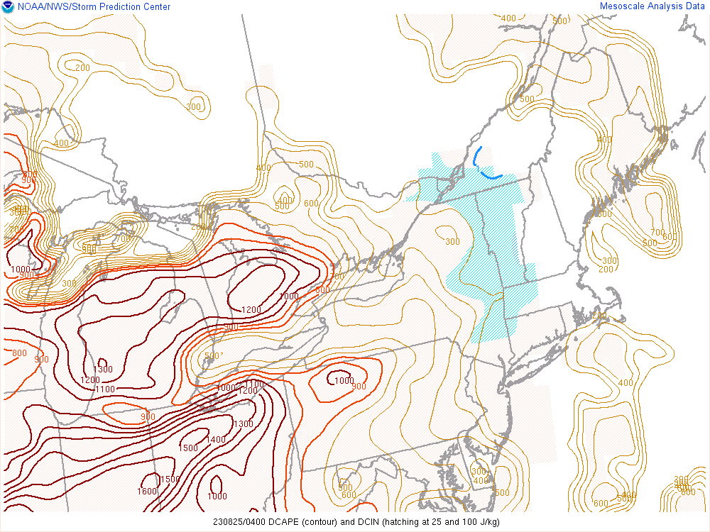 |
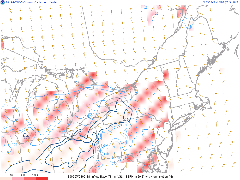
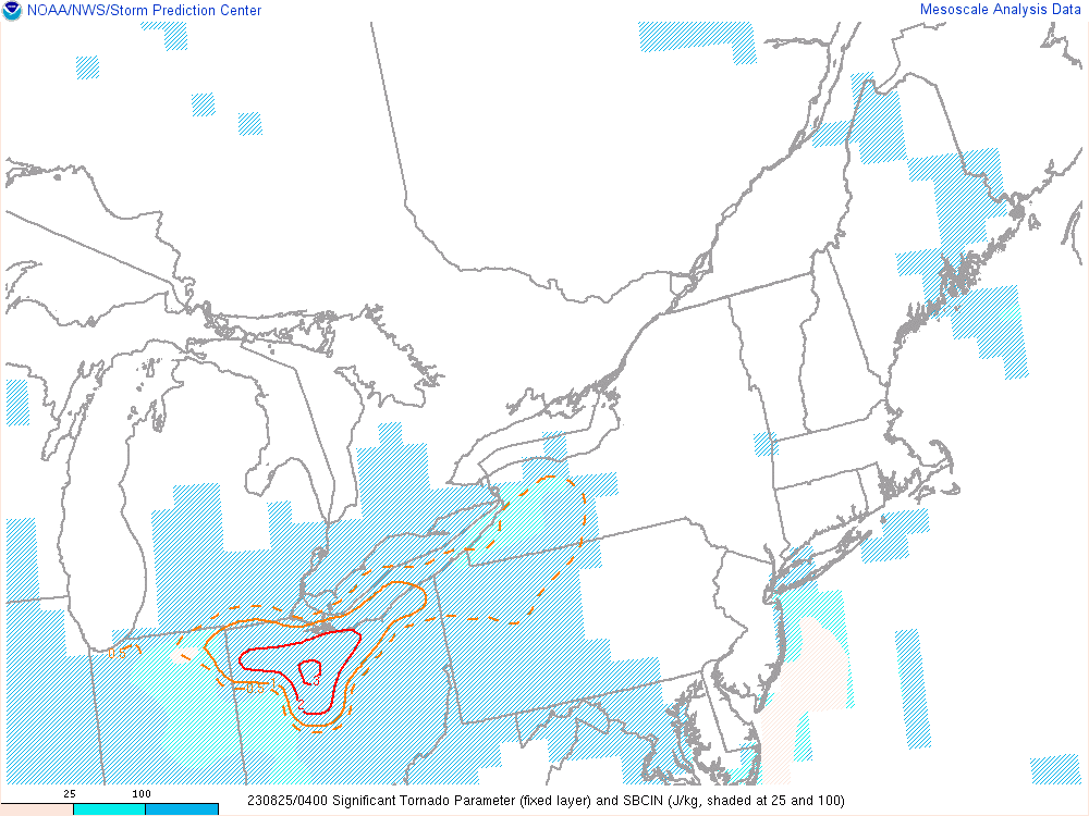
| Figure 4: Effective storm-relative helicity (ESRH) across the Lower Great Lakes at midnight on August 25, 2023. Note strong ESRH values around 300 m2/s2. | Figure 5: Significant tornado parameter (fixed layer) at midnight on August 25, 2023. Note a "ridge" in STP values exceeding 1 extending northeast across Northeast Ohio. | Figure 6: Downdraft CAPE (DCAPE) across the Lower Great Lakes at midnight on August 25, 2023. Note extreme DCAPE values exceeding 1000 J/kg extending northeast across Northeast Ohio. |
 |
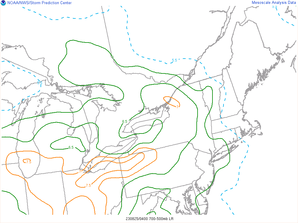 |
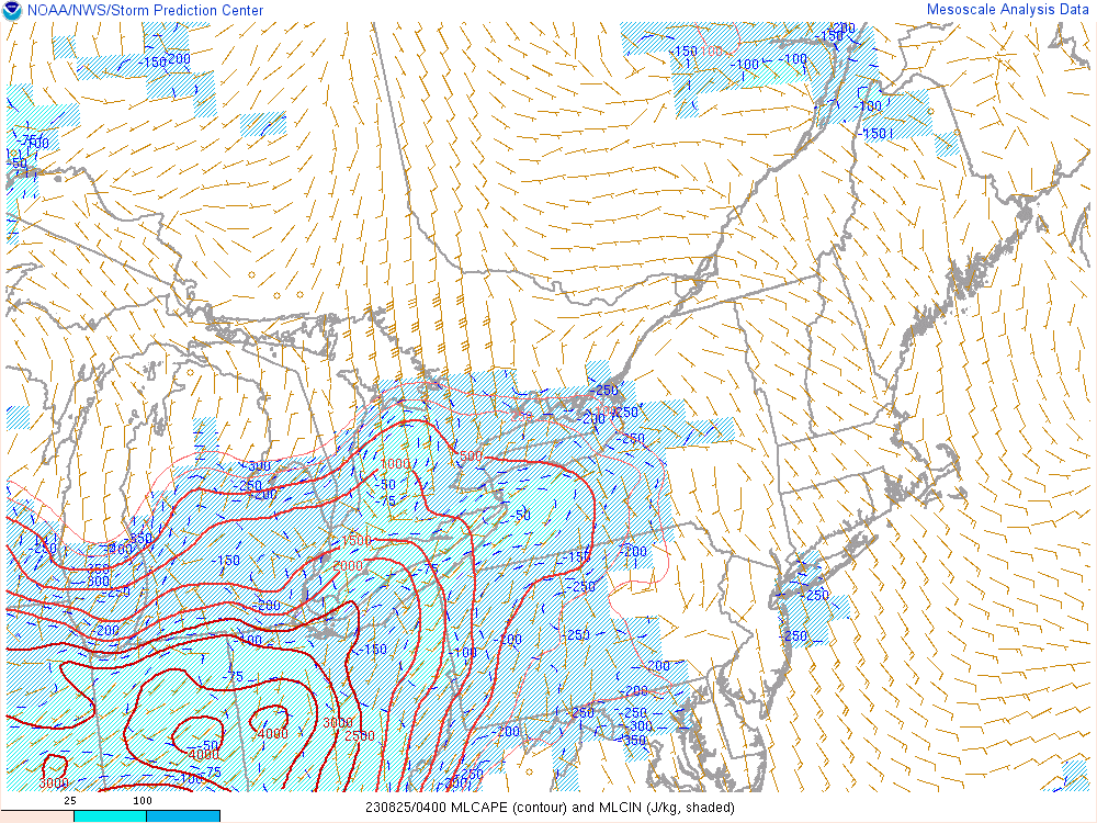
| Figure 7: Mixed-layer CAPE (MLCAPE) across the Lower Great Lakes at midnight on August 25, 2023. Note strong instability present with values exceeding 2500 J/kg. | Figure 8: Mid-level (700 - 500 mb) lapse rates across the Lower Great Lakes at midnight on August 25, 2023. Note anomalously-high values exceeding 7 C/km being advected northeast into the region. |
 |
Media use of NWS Web News Stories is encouraged! Please acknowledge the NWS as the source of any news information accessed from this site. |
|