Overview
|
An unusually warm and humid airmass for mid-April was in place across the local area, well ahead of a cold front that stretched from the central Plains into the northern Great Lakes. Thunderstorms the prior night across the mid-Mississippi Valley evolved into a mesoscale convective vortex, which is essentially a small area of low pressure caused by complexes of thunderstorms. Mesoscale convective vortices, or MCVs, are known to locally enhanced wind shear and add lift to the atmosphere that can encourage renewed thunderstorm development. This feature moved east across northern Ohio during the afternoon and early evening hours on April 15th, interacting with the unseasonable warmth and humidity to cause a round of scattered severe thunderstorms across the area. Many thunderstorms were supercells (i.e. rotating) and produced large hail, up to nearly tennis ball-sized in the southeastern Cleveland suburbs. Some thunderstorms also produced damaging winds, with a microburst producing 90 MPH winds in southeastern Trumbull County. |
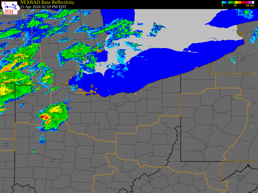 Radar loop from 2 PM to 8 PM EDT on April 15, 2026. |
Wind & Hail:
Wind
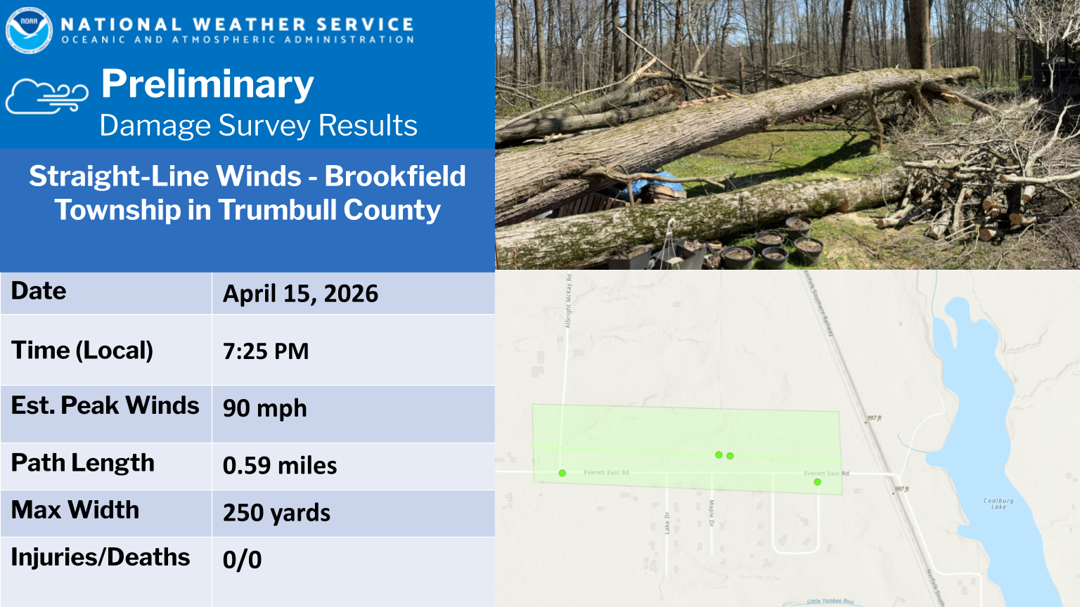
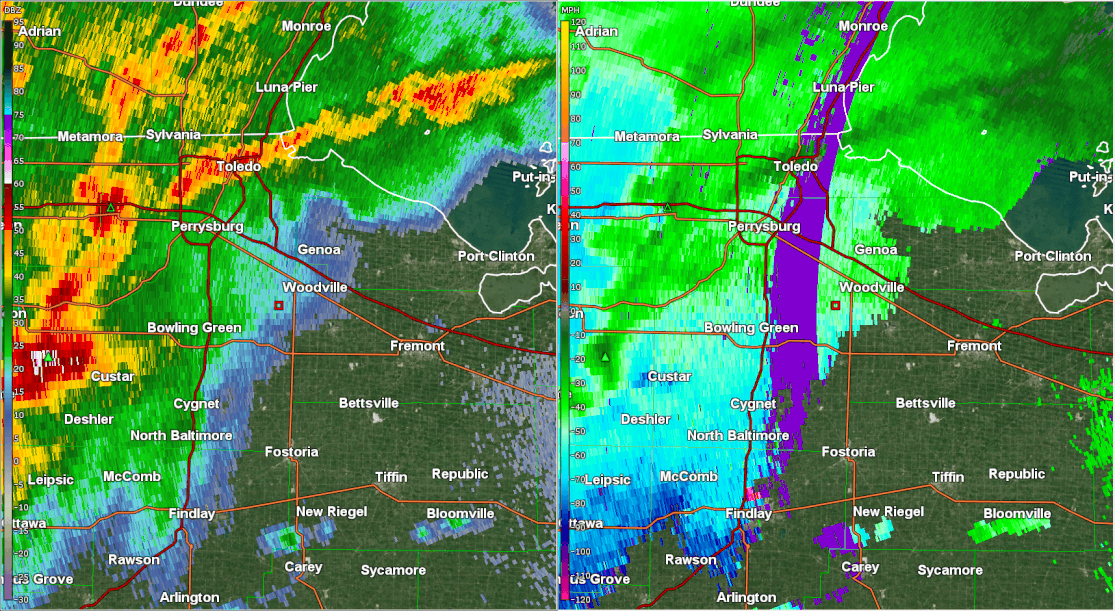
Sporadic wind damage was reported across portions of Northwest Ohio, with a 70 MPH wind gust measured near Martin in Ottawa County. The most organized wind damage occurred in portions of Summit, Portage, Trumbull, and Mahoning Counties during the evening as storms grew into a line. Straight-line winds of as strong as 90 MPH occurred in southeastern Trumbull County with these storms, leading to significant tree damage.
 |
 |
 |
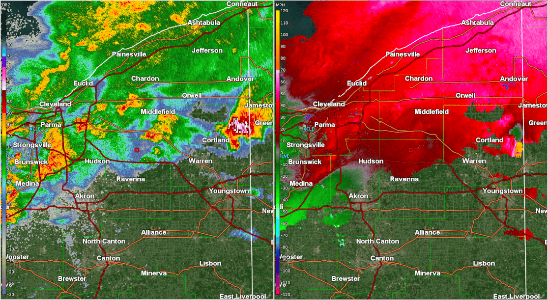 |
| Damage survey summary from intense straight-line winds in southeastern Trumbull County. | Dozens of trees were uprooted or snapped in Brookfield Township in southeastern Trumbull County. Image Credit: NWS Storm Survey. | Radar loop (reflectivity left, base velocity right) from when storms moved across Northwest Ohio and produced sporadic wind damage. Note how portions of the line bow and surge, indicating locally enhanced winds. | Radar loop (reflectivity left, base velocity right) from when storms moved across Northeast Ohio and produced scattered wind damage. Note how storms gradually congealed into a surging line segment, especially across portions of northern Summit, Portage, and Trumbull Counties. |
Hail
A long tracked supercell thunderstorm produced a swath of golf ball-sized or larger hail from the southern Cleveland suburbs points east across portions of Geauga County and Trumbull County. In some locations, hail of 2" in diameter or larger was observed which caused significant damage to cars, homes and businesses. This supercell also produced strong to damaging winds at times, leading to wind driven hail that caused damage to exterior walls/siding and broke windows on the sides of homes and businesses. A few other storms produced hail larger than quarter-sized across the area.
 |
 |
 |
 |
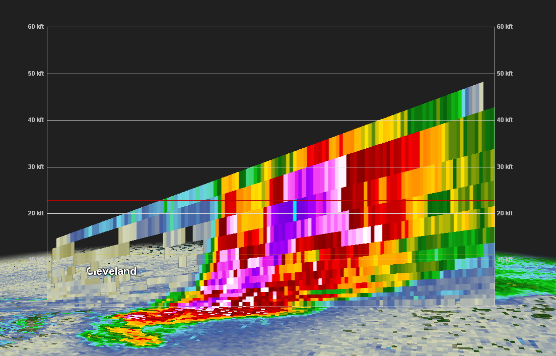
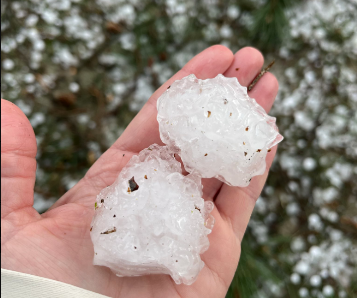
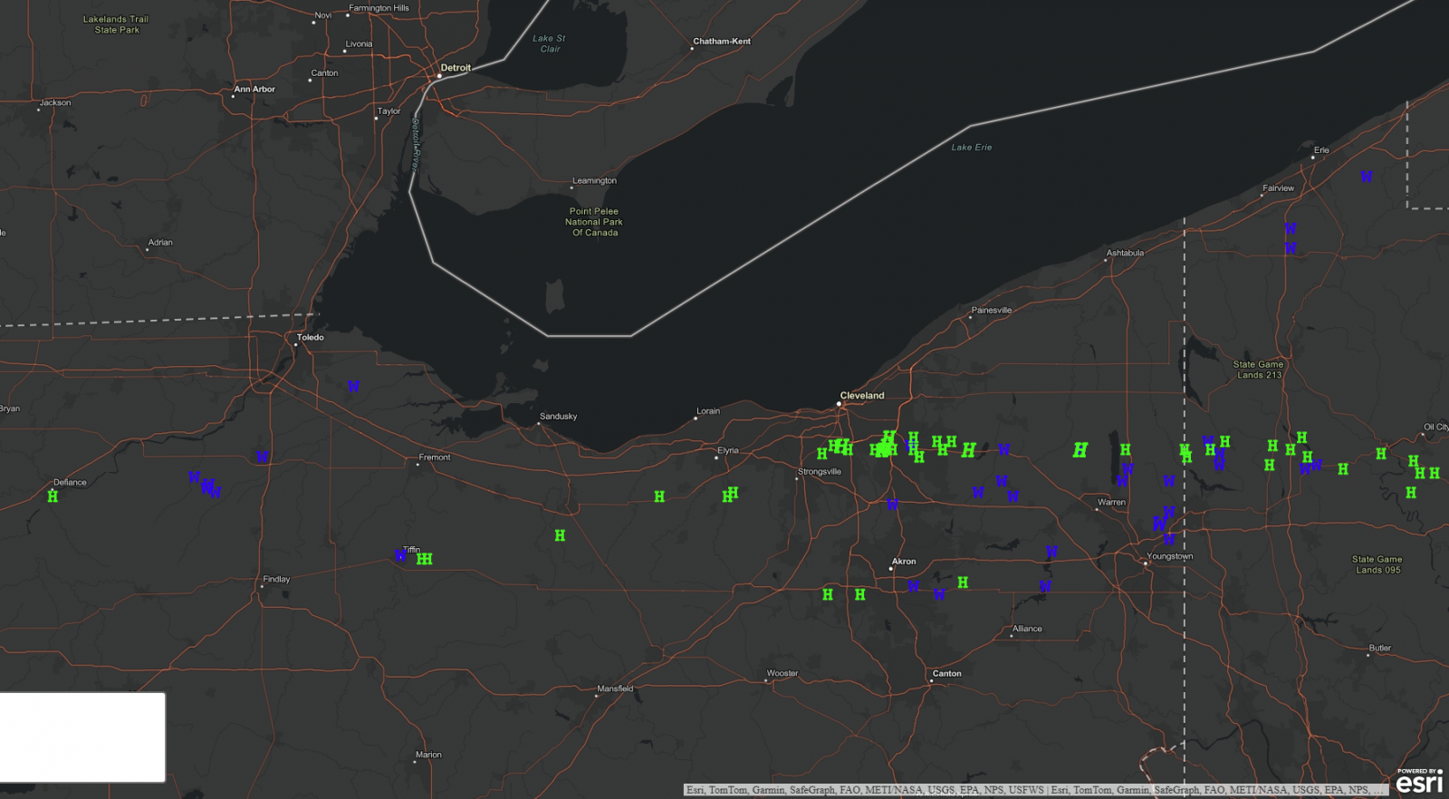
| MRMS radar estimated hail swaths. Oranges tend to correspond to potential for quarter sized or larger hail, with reds and purples corresponding to potential for golf ball sized or larger. Note the swath across portions of Cuyahoga, Geauga, and Trumbull Counties. | Radar cross section of the long tracked supercell as it was over Bedford, Bedford Heights and Solon in southeast Cuyahoga County. Note the "tilted" updraft, characteristic of supercells. Also note the larger area of very high returns lofted over 30,000 feet high, an indicator of very large hail. | Hail near 2 inches in diameter in Solon. Photo Credit: AJ Brilla/X. | Hail near 2 inches in diameter in Bristolville. Photo Credit: Valerie Lord/Facebook. |
Storm Reports
Storm Prediction Center Reports (Interactive Map)
0400 PM Tstm Wnd Dmg 5 SE Mcclure 41.32N 83.88W
04/15/2026 Wood OH Emergency Mngr
Barn collapse.
0403 PM Tstm Wnd Dmg Milton Center 41.30N 83.83W
04/15/2026 Wood OH 911 Call Center
Tree and power-lines downed. Time estimated
via radar.
0403 PM Tstm Wnd Dmg 1 SSE Milton Center 41.28N 83.81W
04/15/2026 Wood OH Public
Tree downed partially onto a moving car on
OH 281 between Milton Road and Weston Road
outside of Custar.
0408 PM Tstm Wnd Dmg Custar 41.29N 83.84W
04/15/2026 Wood OH Public
Collapsed barn. Time estimated via radar.
0412 PM Tstm Wnd Dmg Bowling Green 41.37N 83.65W
04/15/2026 Wood OH 911 Call Center
Tree and power-lines downed in Bowling
Green.
0430 PM Tstm Wnd Gst 1 N Martin 41.55N 83.34W
04/15/2026 M70 MPH Ottawa OH Trained Spotter
70mph wind gusts measured on home weather
station.
0434 PM Hail 3 E Tiffin 41.11N 83.11W
04/15/2026 M1.00 Inch Seneca OH Trained Spotter
0440 PM Hail Solon 41.37N 81.42W
04/15/2026 E1.75 Inch Cuyahoga OH Public
Corrects previous hail report from Solon.
Images shared via social media of large
hail.
0441 PM Hail 2 NE Middleburg Heights 41.39N 81.80W
04/15/2026 E0.75 Inch Cuyahoga OH Public
Report from mPING: Dime (0.75 in.).
0446 PM Hail Parma Heights 41.39N 81.76W
04/15/2026 E0.88 Inch Cuyahoga OH Amateur Radio
0447 PM Hail 1 NE Parma 41.40N 81.71W
04/15/2026 E1.00 Inch Cuyahoga OH Public
0448 PM Hail 1 ESE Parma Heights 41.38N 81.75W
04/15/2026 M1.00 Inch Cuyahoga OH NWS Employee
0455 PM Hail 1 N Seven Hills 41.40N 81.68W
04/15/2026 M1.50 Inch Cuyahoga OH NWS Employee
.
0455 PM Hail 1 N Seven Hills 41.40N 81.68W
04/15/2026 M2.00 Inch Cuyahoga OH NWS Employee
Updated previous hail report from 1 N Seven
Hills to 2 inch diameter hail.
0458 PM Hail 1 NNE Seven Hills 41.39N 81.66W
04/15/2026 E1.50 Inch Cuyahoga OH Broadcast Media
0500 PM Hail Bedford 41.39N 81.53W
04/15/2026 M1.25 Inch Cuyahoga OH Law Enforcement
0502 PM Hail Bedford 41.39N 81.54W
04/15/2026 M2.00 Inch Cuyahoga OH Public
Picture of hail slightly over 2 inch in
diameter received from Bedford.
0502 PM Hail Bedford 41.39N 81.51W
04/15/2026 E1.00 Inch Cuyahoga OH Public
Significant accumulation of hail on I271
creating a slush and slowing traffic.
0503 PM Hail 1 SE North Randall 41.42N 81.52W
04/15/2026 M2.00 Inch Cuyahoga OH Trained Spotter
Hail lasted 10 to 15 minutes ranging in size
from 1.00 to 2.00 inches in diameter.
0503 PM Hail 1 SW Maple Heights 41.39N 81.57W
04/15/2026 E1.75 Inch Cuyahoga OH Public
0503 PM Hail 1 NNE Bedford 41.40N 81.53W
04/15/2026 M2.00 Inch Cuyahoga OH Law Enforcement
0503 PM Hail 5 SSW Norwalk 41.17N 82.64W
04/15/2026 E1.00 Inch Huron OH Emergency Mngr
0505 PM Tstm Wnd Dmg Tiffin 41.12N 83.18W
04/15/2026 Seneca OH Public
Corrects previous tstm wnd dmg report from
Tiffin. Straight line wind damage, several
power poles (6-8) knocked down.
0509 PM Hail 2 SSW Moreland Hills 41.42N 81.44W
04/15/2026 E1.50 Inch Cuyahoga OH Public
Delayed report. Time estimated via radar.
0509 PM Hail Solon 41.39N 81.44W
04/15/2026 E1.00 Inch Cuyahoga OH Trained Spotter
0509 PM Hail 4 WSW Republic 41.11N 83.09W
04/15/2026 E1.25 Inch Seneca OH Public
0510 PM Tstm Wnd Dmg 1 NNW Solon 41.40N 81.45W
04/15/2026 Cuyahoga OH Emergency Mngr
Significant storm damage in Solon from a
combination of wind and hail. Numerous trees
were downed with some falling onto houses.
Damage to siding and windows due to wind
driven hail.
0510 PM Hail Solon 41.37N 81.42W
04/15/2026 E1.75 Inch Cuyahoga OH Public
Images shared via social media of large
hail.
0515 PM Hail 2 NW Bainbridge 41.41N 81.36W
04/15/2026 E1.75 Inch Geauga OH Public
Report from mPING: Golf Ball (1.75 in.).
0516 PM Hail Bainbridge 41.39N 81.34W
04/15/2026 E1.00 Inch Geauga OH Public
Corrects previous hail report from
Bainbridge. Public report of significant
accumulation of one inch and greater hail.
0518 PM Tstm Wnd Dmg 5 N Hiram 41.39N 81.13W
04/15/2026 Geauga OH Dept of Highways
Several trees down. Time estimated via
radar.
0520 PM Hail 2 NE Bainbridge 41.41N 81.31W
04/15/2026 E1.75 Inch Geauga OH Public
Report from mPING: Golf Ball (1.75 in.).
0521 PM Hail 5 E Bainbridge 41.39N 81.25W
04/15/2026 E2.00 Inch Geauga OH Broadcast Media
Time estimated via radar.
0527 PM Hail Kipton 41.27N 82.30W
04/15/2026 E1.75 Inch Lorain OH Trained Spotter
0543 PM Hail 2 W Grafton 41.27N 82.07W
04/15/2026 M1.25 Inch Lorain OH Public
Time estimated via radar.
0546 PM Hail 5 E West Farmington 41.39N 80.87W
04/15/2026 M2.00 Inch Trumbull OH Trained Spotter
Time estimated via radar.
0548 PM Hail Intersection SR10 and S 41.34N 82.06W
04/15/2026 M0.25 Inch Lorain OH Trained Spotter
0548 PM Tstm Wnd Dmg Bristolville 41.39N 80.87W
04/15/2026 Trumbull OH Public
Significant damage from a combination of
wind and hail in Bristolville, including
downed trees and power polls along with
damage to siding, roofs and windows.
0548 PM Hail Bristolville 41.39N 80.87W
04/15/2026 M2.00 Inch Trumbull OH Public
Corrects previous hail report from
Bristolville. Social media images of large
hail and damaged vehicles.
0553 PM Hail Grafton 41.28N 82.05W
04/15/2026 E1.00 Inch Lorain OH Public
0600 PM Tstm Wnd Dmg 2 SSW Cortland 41.31N 80.73W
04/15/2026 Trumbull OH Trained Spotter
Tree down.
0606 PM Hail Mecca 41.39N 80.72W
04/15/2026 E1.00 Inch Trumbull OH Public
Intersection of SR 88 and Phillips Rice Rd.
0608 PM Tstm Wnd Dmg 1 NE Cortland 41.34N 80.71W
04/15/2026 Trumbull OH Public
Numerous branches broken.
0610 PM Tstm Wnd Dmg Hartford 41.31N 80.57W
04/15/2026 Trumbull OH 911 Call Center
Several trees downed in Hartford Twp.
0613 PM Hail 3 N Orangeville 41.39N 80.52W
04/15/2026 M1.50 Inch Trumbull OH Public
Report from mPING: Ping Pong Ball (1.50
in.).
0619 PM Tstm Wnd Dmg Boston Heights 41.25N 81.51W
04/15/2026 Summit OH Law Enforcement
-Delayed Report- Several trees downed in
Boston Heights, with a few roads closed into
the following day for cleanup.
0630 PM Hail Wadsworth 41.02N 81.73W
04/15/2026 E1.00 Inch Medina OH Public
Mainly dime to penny-sized but some as large
as quarters.
0633 PM Hail Wadsworth 41.03N 81.73W
04/15/2026 M0.70 Inch Medina OH 911 Call Center
0636 PM Hail Doylestown 40.99N 81.71W
04/15/2026 E0.25 Inch Medina OH Trained Spotter
Pea size hail reported between Wadsworth and
Doylestown.
0639 PM Hail 1 NW Barberton 41.02N 81.62W
04/15/2026 E1.00 Inch Summit OH Public
-Delayed Report- Brief quarter-sized hail in
western Barberton.
0640 PM Tstm Wnd Dmg Mantua 41.28N 81.22W
04/15/2026 Portage OH Public
-Delayed Report- Several trees downed in
Mantua, including one on a car and another
on a house.
0645 PM Tstm Wnd Dmg Hiram 41.31N 81.14W
04/15/2026 Portage OH 911 Call Center
Two downed trees in Hiram.
0645 PM Hail Barberton 41.02N 81.61W
04/15/2026 E0.25 Inch Summit OH Trained Spotter
0646 PM Tstm Wnd Dmg 1 NW Lakemore 41.04N 81.44W
04/15/2026 Summit OH Public
A few trees downed in Sawyerwood/Springfield
Twp.
0648 PM Tstm Wnd Dmg 1 S Garrettsville 41.27N 81.10W
04/15/2026 Portage OH Public
-Delayed Report- Numerous large limbs and
trees downed.
0652 PM Marine Tstm Wind 5 NE Fairview 42.08N 80.18W
04/15/2026 M46 MPH Erie PA ASOS
ASOS station KERI Erie.
0657 PM Tstm Wnd Dmg 3 SE Mogadore 41.02N 81.35W
04/15/2026 Portage OH 911 Call Center
Several trees downed in Suffield Township.
0704 PM Tstm Wnd Dmg 1 NE Craig Beach 41.13N 80.97W
04/15/2026 Mahoning OH 911 Call Center
A couple of trees downed in Milton Twp near
the Trumbull Co line.
0705 PM Hail 5 ESE Brimfield 41.05N 81.27W
04/15/2026 M1.00 Inch Portage OH Public
Quarter sized hail reported by the public.
0710 PM Tstm Wnd Dmg 6 SSE Harborcreek 42.08N 79.90W
04/15/2026 Erie PA Broadcast Media
Tree downed and blocking road. Time
estimated via radar.
0715 PM Tstm Wnd Dmg 4 SSW Mckean 41.95N 80.16W
04/15/2026 Erie PA 911 Call Center
A few trees downed across central Erie
County.
0719 PM Tstm Wnd Dmg 2 NW Edinboro 41.90N 80.16W
04/15/2026 Erie PA Trained Spotter
Pine tree snapped.
0725 PM Tstm Wnd Dmg 5 S Craig Beach 41.04N 80.99W
04/15/2026 Mahoning OH 911 Call Center
Tree downed. Time estimated via radar.
0725 PM Tstm Wnd Dmg Brookfield 41.23N 80.57W
04/15/2026 Trumbull OH 911 Call Center
Trees downed in Brookfield.
0725 PM Tstm Wnd Gst 3 SW Brookfield Center 41.20N 80.60W
04/15/2026 E90 MPH Trumbull OH NWS Storm Survey
-Delayed Report- Storm survey found damage
consistent with 90 MPH straight line winds
along Everett East Road in Brookfield
Township. Dozens of trees were uprooted or
snapped. Two homes sustained damage from
falling limbs.
0726 PM Tstm Wnd Dmg Hubbard 41.16N 80.57W
04/15/2026 Trumbull OH 911 Call Center
Trees downed in and around Hubbard.
Environment
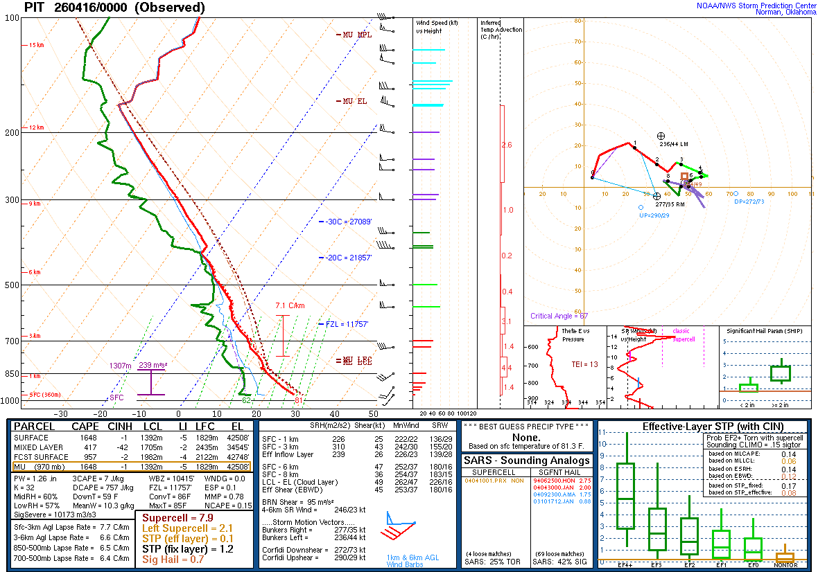
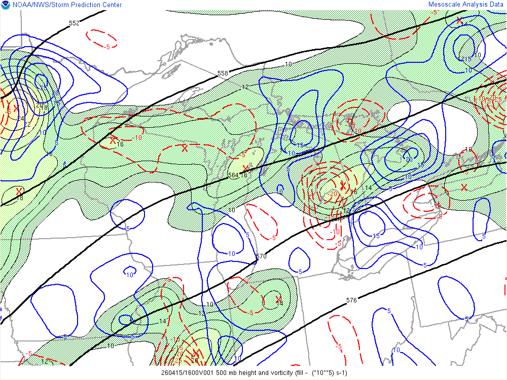
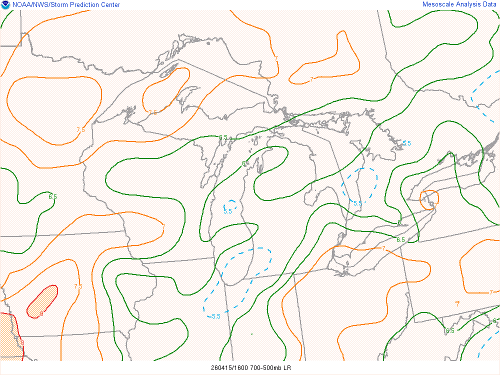
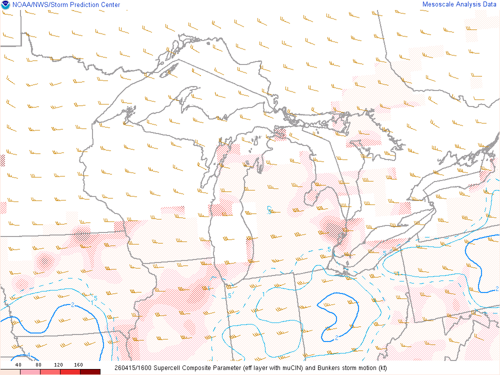
Thunderstorms were not forced by a strong front of disturbance, but a weaker form of lift called a mesoscale convective vortex (MCV) leftover from thunderstorms the night before to our west. This weaker form of lift, combined with strong deep-layer shear (analyzed at 40-50 knots per both SPC mesoanalysis and regional upper air soundings), favored a mix of supercells (thunderstorms with rotating updrafts) and short squall lines and bow echoes. Supercell thunderstorms are favorable hail producers, especially in the presence of steeper 700-500mb lapse rates. This combination helped result in a swath of significant hail with a long-tracked supercell thunderstorm from the southern Cleveland suburbs across Geauga and Trumbull Counties and into western Pennsylvania. Strong winds aloft also helped bowing line segments produce swaths of damaging winds across portions of the area.
 |
 |
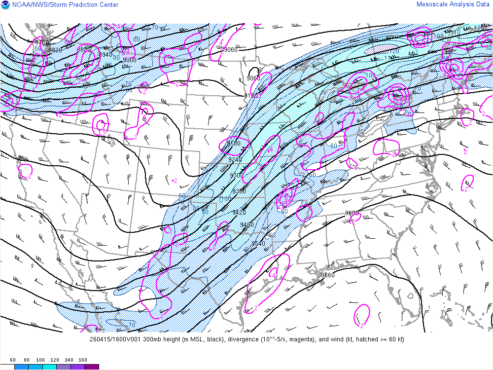 |
| Figure 1: Weather Prediction Center surface maps valid from 8 AM to 11 PM April 15, 2026. Note the frontal boundaries are well to the west and northwest of the area. | Figure 2: Observed sounding from Pittsburgh, PA valid 8 PM April 15, 2026. Note the moderately steep 700-500mb lapse rates and strong deep-layer shear, both of which can favor rotating thunderstorms and hail. The low-levels were a bit dry, which helped limit the overall tornado risk. | Figure 3: Analyzed 300mb heights, winds, and divergence, courtesy SPC Mesoanalysis. |
 |
.gif) |
.gif) |
| Figure 4: Analyzed 500mb heights, vorticity, and vorticity advection, courtesy SPC Mesoanalysis. | Figure 5: Analyzed MLCAPE, MLCIN, and 10m winds, courtesy SPC Mesoanalysis. | Figure 6: Analyzed effective bulk shear, courtesy SPC Mesoanalysis. |
 |
 |
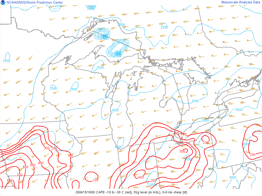 |
| Figure 7: Analyzed 500-700mb lapse rates, courtesy SPC Mesoanalysis. | Figure 8: Analyzed Supercell Composite Parameter, courtesy SPC Mesoanalysis. | Figure 9: Analyzed "hail parameters" (CAPE between -10C and -30C, freezing level, and 0-6km shear) courtesy SPC Mesoanalysis. |
 |
Media use of NWS Web News Stories is encouraged! Please acknowledge the NWS as the source of any news information accessed from this site. |
|

