National Weather Service United States Department of Commerce

November 13-14, 2010, Heavy Snow


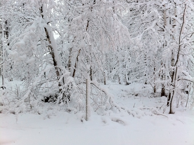
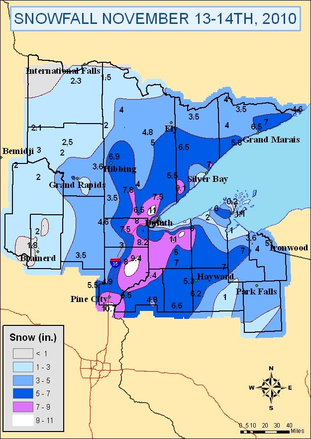
A GIS map of snowfall accumulations in the NWS Duluth county warning area. The wintry scene looking out one of our office's west facing windows. The trees and shrubs are all coated in a thick layer of snow.


Here are a few notes about the snowfall accumulations:

  • The snow started off as a very wet, heavy snow that stuck to elevated surfaces. The weight of the snow contributed to downed trees, particularly across northwest Wisconsin and near the Interstate 35 corridor.
  • Rain mixing in at some locations, as well as surface temperatures near or above freezing, caused the snow to compact. Therefore, the depth of the snow at the end of the event was likely lower than the actual total accumulation in some areas.
  • To illustrate the effect that the warmer temperatures had, consider what we observed at our office through noon on November 14th. While the total snow accumulation was 10.6 inches (measurements added every couple hours), the snow depth was only 8 inches.
  • Snow rates in the afternoon on November 13th reached between 1 and 1.5 inches per hour at times. We had a peak rate of 1.2 inches per hour at our office between 1pm and 2pm CST.
  • Snow accumulations were limited near Lake Superior as the lake water temperatures were still rather warm, and the winds were off the lake for the bulk of the snow storm.

Snow Totals

INCHES  LOCATION                 ST  COUNTY           TIME
 ------  -----------------------  --  --------------   -------
 11.00   7 NW DULUTH              MN  ST. LOUIS        1045 AM
 11.00   HAWTHORNE                WI  DOUGLAS          0830 AM
 10.90   4 S BRUNO                MN  PINE             0800 AM
 10.90   5 NW DULUTH              MN  ST. LOUIS        1159 PM
 10.50   MAPLE                    WI  DOUGLAS          0900 AM
  8.40   2 E ESKO                 MN  CARLTON          0900 AM
  8.20   HOLYOKE                  MN  CARLTON          0930 AM
  8.00   CLOQUET                  MN  CARLTON          0207 PM
  8.00   OULU                     WI  BAYFIELD         1100 AM
  8.00   SOUTH RANGE              WI  DOUGLAS          0830 AM
  7.80   2 E PAYNE                MN  ST. LOUIS        0817 AM
  7.60   DANBURY                  WI  BURNETT          0721 AM
  7.50   4 E ISLAND LAKE          MN  ST. LOUIS        0900 AM
  7.50   3 WNW CLOQUET            MN  CARLTON          0836 AM
  7.50   4 SW SAWYER              MN  CARLTON          0818 AM
  7.20   2 W BAYFIELD             WI  BAYFIELD         0729 AM
  7.00   2 N MELLEN               WI  ASHLAND          0345 PM
  7.00   11 NE GRAND MARAIS       MN  COOK             0130 PM
  7.00   3 NNW ILLGEN CITY        MN  LAKE             0950 AM
  7.00   4 W CLAM LAKE            WI  BAYFIELD         0700 AM
  6.90   CHISHOLM                 MN  ST. LOUIS        0800 AM
  6.60   SARONA                   WI  WASHBURN         1228 PM
  6.50   5 NNE GRAND MARAIS       MN  COOK             0335 PM
  6.50   SAGINAW                  MN  ST. LOUIS        1110 AM
  6.50   4 N GRANTSBURG           WI  BURNETT          0930 AM
  6.20   8 S HAYWARD              WI  SAWYER           1005 AM
  6.00   CORNUCOPIA               WI  BAYFIELD         1110 AM
  5.80   LUTSEN                   MN  COOK             0237 PM
  5.80   6 W TWO HARBORS          MN  ST. LOUIS        0700 AM

  5.30   2 WSW HAYWARD            WI  SAWYER           0713 AM
  5.00   GILE                     WI  IRON             0700 AM
  4.90   3 WSW HINCKLEY           MN  PINE             0630 AM
  4.80   2 S TOWER                MN  ST. LOUIS        0730 AM
  4.80   ELY                      MN  ST. LOUIS        0700 AM
  4.70   WRENSHALL                MN  CARLTON          0950 AM
  4.00   20 N TOFTE               MN  COOK             0120 PM
  4.00   COTTON                   MN  ST. LOUIS        1210 PM
  3.60   NASHWAUK                 MN  ITASCA           0700 AM
  3.50   3 SW SNOWBANK LAKE       MN  LAKE             0126 PM
  3.50   6 SE GUNFLINT LAKE       MN  COOK             0846 AM
  3.50   12 N ISLE                MN  AITKIN           0800 AM
  3.00   5 S HERBSTER             WI  BAYFIELD         1100 AM
  2.50   5 SE GRAND RAPIDS        MN  ITASCA           1000 AM
  2.50   SILVER BAY               MN  LAKE             0800 AM
  2.50   GRAND RAPIDS             MN  ITASCA           0700 AM
  2.50   INTERNATIONAL FALLS      MN  KOOCHICHING      1159 PM
  2.30   LITTLEFORK               MN  KOOCHICHING      0800 AM
  2.20   GURNEY                   WI  IRON             0700 AM
  2.00   5 S HERBSTER             WI  BAYFIELD         0727 AM
  2.00   BOWSTRING                MN  ITASCA           0702 AM
  2.00   BREEZY POINT             MN  CROW WING        0700 AM
  1.80   7 NW BRAINERD            MN  CROW WING        0700 AM
  1.50   3 N BRAINERD             MN  CROW WING        0900 AM
  1.50   KABETOGAMA               MN  ST. LOUIS        0700 AM
  1.10   MADELINE ISLAND          WI  ASHLAND          0735 AM
  1.00   7 ESE SUPERIOR           WI  DOUGLAS          1000 AM
  0.50   3 NE NISSWA              MN  CROW WING        0818 AM
  0.40   WEST DULUTH              MN  ST. LOUIS        0151 PM
  0.20   9 N BAYFIELD             WI  BAYFIELD         0700 AM
  0.00   SUPERIOR                 WI  DOUGLAS          0830 AM
nws logo Media use of NWS Web News Stories is encouraged!
Please acknowledge the NWS as the source of any news information accessed from this site.
nws logo