Overview
|
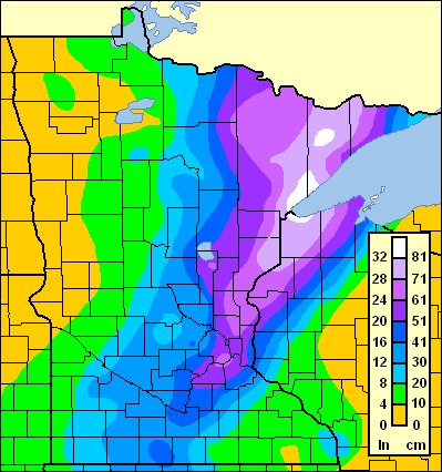
The snowstorm that hit parts of the Northland starting around Halloween (October 31 - November 3) in 1991 was an impressive storm in many respects, and it is still remembered by many people across the region. In fact, this storm was set up, in part, by the weather patterns that caused the "Perfect Storm" that struck the East Coast of the United States, and was famously depicted in Sebastian Junger's book. Moreover, the "Perfect Storm" was beginning to wind down in the Northeast on Halloween, around the same time that Minnesota was starting to see heavy snow creeping in. To have two exceptional storms impacting the continental United States at the same time is quite rare. During the height of trick-or-treating the storm began as rain, then changed quickly to freezing rain and before the evening was over, it was snowing. It continued to snow for two more days, with final totals of 36.9 inches at the Duluth Airport and 45 inches in Superior. A large area of more than 20 inches of snow covered most of the northwest quarter of Wisconsin from Bayfield to River Falls and near the eastern half of Minnesota. At times the snow fell at a rate of two inches per hour and was accompanied by thunder and lightning. In addition, winds gusting to to 40 mph created huge snowdrifts and zero visibility. Fast Facts:
|
 Total Snowfall, Halloween Storm, October 31-Nov 3, 1991 |
Snow
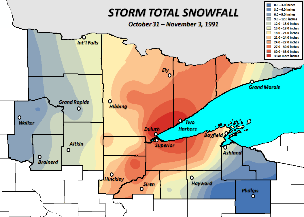
| Location | County | Total Snowfall |
| Duluth, MN | St. Louis | 36.9" |
| Two Harbors | Lake | 36.0" |
| Brule, WI | Douglas | 32.0" |
| 1E Brimson, MN | St. Louis | 32.0" |
| 7ENE Bruno, MN | Pine | 32.0" |
| Superior, WI | Douglas | 31.5" |
| 10 NW Gunflint Lake, MN | Cook | 30.0" |
| Eveleth, MN | St. Louis | 30.0" |
| Danbury, WI | Burnett | 28.0" |
| Solon Springs, WI | Douglas | 28.0" |
| Gordon, WI | Douglas | 25.9" |
| Grantsburg, WI | Burnett | 25.0" |
| 3NNE Lutsen, MN | Cook | 25.0" |
| Drummond, WI | Bayfield | 24.0" |
| Hinckley, MN | Pine | 24.0" |
| 4NW Wright, MN | Carlton | 24.0" |
| 3S Tower, MN | St. Louis | 23.0" |
| Cotton, MN | St. Louis | 22.1" |
| 6N Bayfield, WI | Bayfield | 20.0" |
| Floodwood, MN | St. Louis | 20.0" |
| 1SSE Moose Lake, MN | Carlton | 19.2" |
| Cloquet, MN | Carlton | 18.6" |
| International Falls, MN | Koochiching | 16.8" |
| Madeline Island, WI | Ashland | 16.5" |
| Grand Marais, MN | Cook | 16.0" |
| Hayward, WI | Sawyer | 16.0" |
| Spooner, WI | Washburn | 14.5" |
| Sandy Lake Dam, MN | Aitkin | 14.0" |
| Remer, MN | Cass | 14.0" |
| 5 NE Marcell, MN | Itasca | 11.9" |
| Brainerd, MN | Crow Wing | 11.0" |
| Grand Rapids, MN | Itasca | 10.4" |
| Winnibigoshish Dam, MN | Cass | 10.0" |
| Pine River, MN | Cass | 9.0" |
| Gull Lake Dam, MN | Cass | 8.6" |
| 4NE Mellen, WI | Ashland | 7.6" |
| Cass Lake, MN | Cass | 7.1" |
| Walker, MN | Cass | 7.0" |
| Grand Portage, MN | Cook | 7.0" |
| Gurney, WI | Iron | 6.4" |
| Federal Dam, MN | Cass | 5.6" |
| Winter, WI | Sawyer | 0.2" |
| Prentice, WI | Price | Trace |
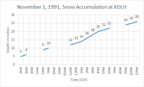
This graph shows the snow accumulation at KDLH on November 1, 1991. Notice the 3-hour period of 2" per hour snowfall rates between 1PM and 4PM.
Photos
 |
 |
 |
 |
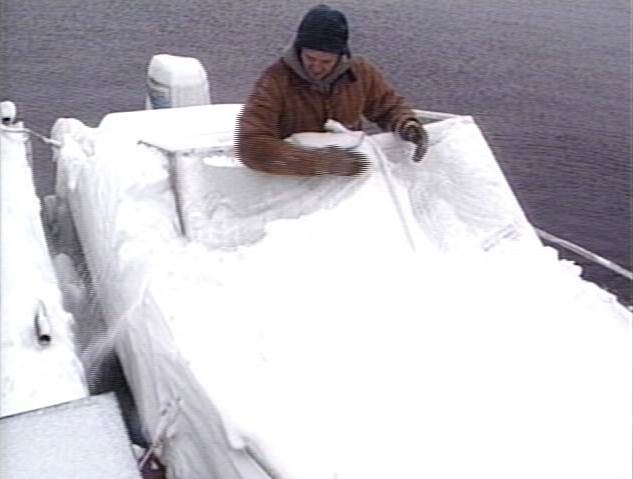
| A boat covered in snow. (NWS DLH Event Archive) |
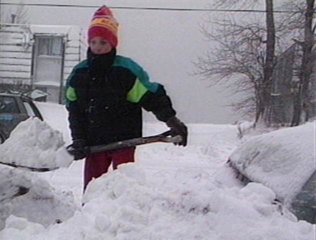
A boy shovels out during the event. (NWS DLH Event Archive) |
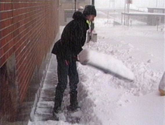
A person shoveling during the event. (NWS DLH Event Archive) |
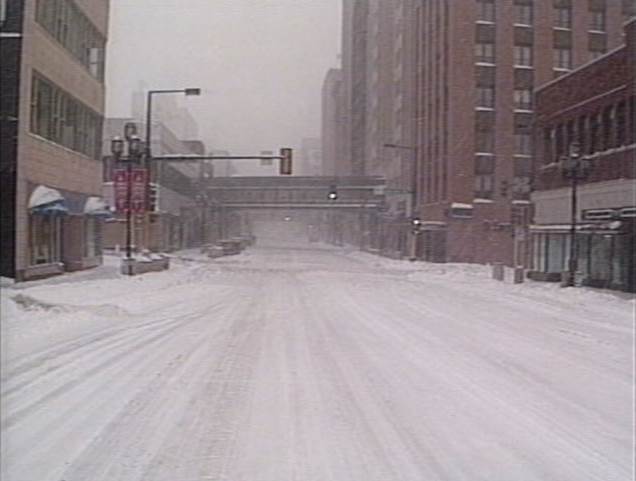
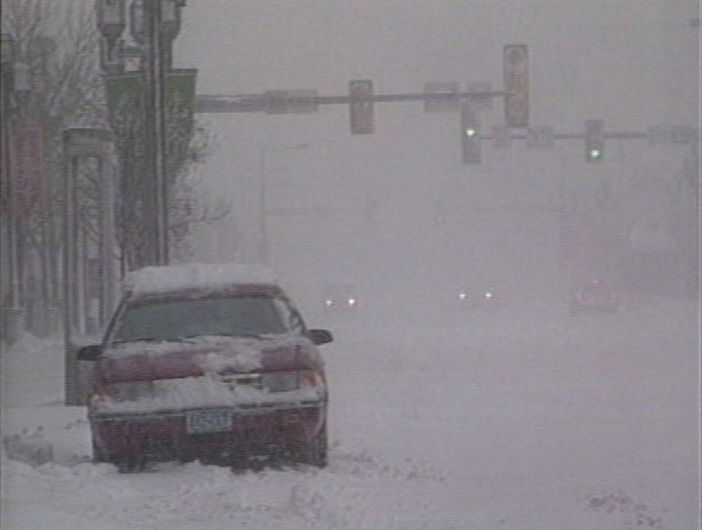
The intersection of W Superior St and 4th Ave West in Duluth during the storm. (NWS DLH Event Archive) |
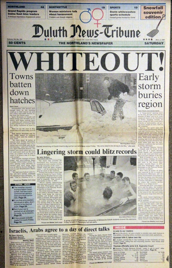
The front page of the Duluth News Tribune from November 2, 1991.
Environment
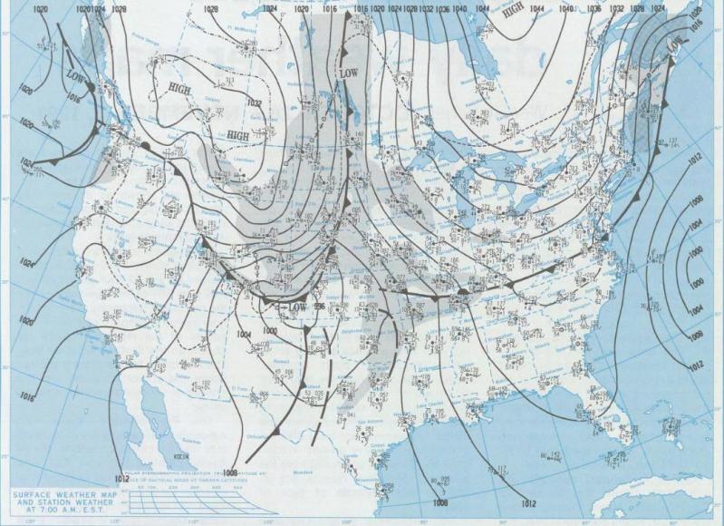
 The "Halloween Blizzard" was made possible by a strong Arctic cold front that surged south through the central United States several days prior. On October 28, 1991, temperatures in advance of the cold front were quite pleasant as high temperatures reached into the 70s from the Mid-Mississippi River Valley south into North Texas, and into the 80s across much of central and southern Texas. Meanwhile, high temperatures did not crack 20 degrees across most of Montana and Wyoming.
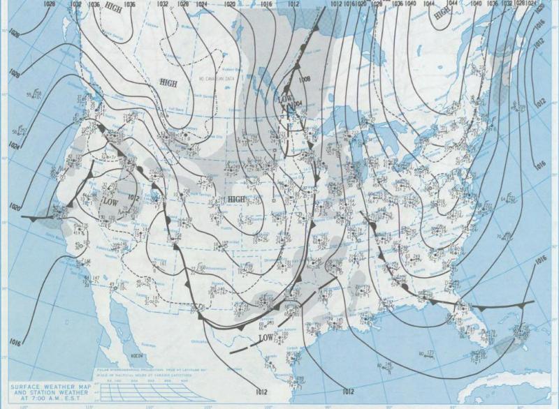
The contrast between the two air masses was stark, and by the morning of October 29th, the cold front was already about halfway through Texas. At 6 AM CST, the temperature in Amarillo, Texas, had plummeted to 22 degrees with a stiff northerly breeze. Abilene, Texas, was reporting a temperature of 40, while Dallas came in at 64 - a 24 degree difference over about 180 miles. Meanwhile, morning lows were much more frigid to the north - in the single digits across Montana and Wyoming, and in the teens (with snow) in the Dakotas.
A broad upper level trough, or low pressure area, was in place over the western US at this time, with one particular shortwave (a disturbance, or small area of low pressure aloft) lifting northeast through the Dakotas, and another digging to the southeast into the Intermountain West. By October 30th, the cold front had reached the Texas Gulf Coast and stalled in that location. As the shortwave aloft rounded the base of the broad trough and approached the Southern Plains, it aided the development of an area of surface low pressure along the sharp temperature gradient near the Texas Gulf Coast. The development of low pressure systems along coastal fronts in this fashion is relatively common in the cool season along the Texas Gulf Coast and along the Atlantic Seaboard near the Gulf Stream current.
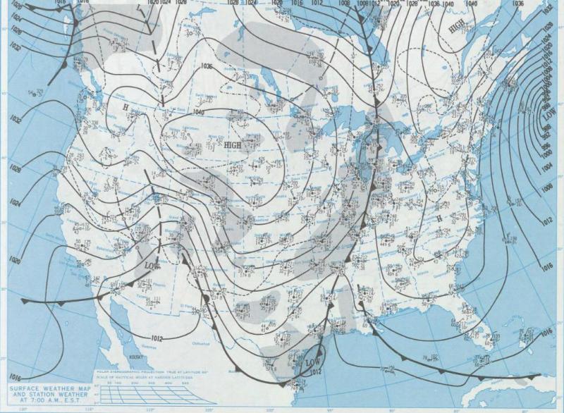
From October 30th into the 31st, this low pressure system slowly became better organized over Texas, before it ejected north over the Mississippi River Valley. This trajectory of a low pressure track (almost due north from the western Gulf) is climatologically favorable to produce very heavy snowfall in the winter months because it allows copious amounts of moisture to surge north where they can interact with colder air. Cooler readings lingered at the very end of October across the Upper Midwest, and a reinforcing shot of Arctic air was just beginning to push southeast through the western Canadian Provinces.
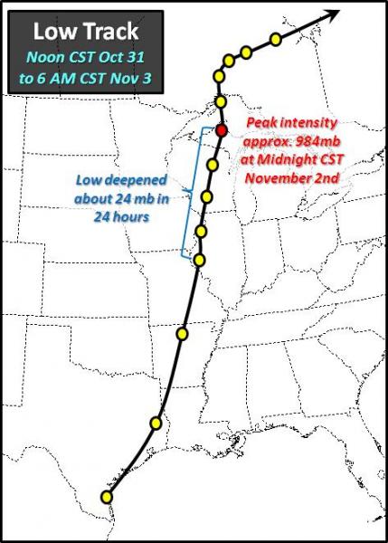
On November 1st, the surface low pressure moved north from western Illinois into the Upper Peninsula of Michigan and the minimum pressure fell about 24 millibars in 24 hours, indicative of rapid deepening and strengthening of the cyclone. This was when the heavier snow set in across the Northland, and winds became quite gusty - producing some blizzard conditions with visibilities at or below 1/4 mile at times. Snowfall rates occasionally peaked in the 1 to 2 inches per hour range.
The low pressure eventually became occluded, weakened, and then continued to dissipate as it pushed east across northern Ontario in subsequent days. When the storm had exited, it had taken quite a toll on the area. Almost every place received at least a foot of snow, with lower totals to the west of the International Falls, Grand Rapids, and Brainerd areas as they were further away from the low, and also east of the Ashland and Hayward areas where warmer air kept snow from accumulating as much. Snow drifts were as high as 6 to 10 feet in some areas, and a few spots saw businesses and schools closed for several days.
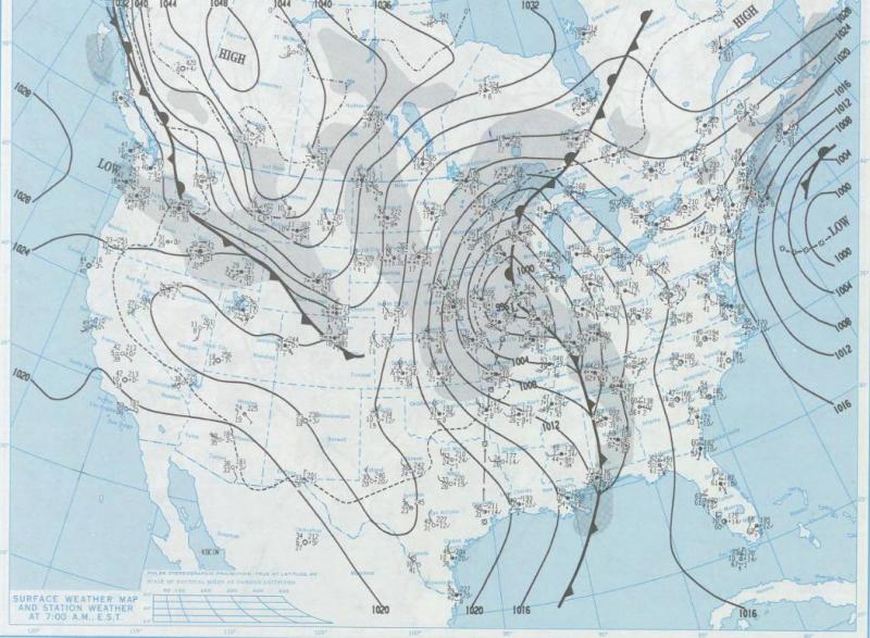
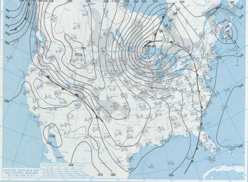
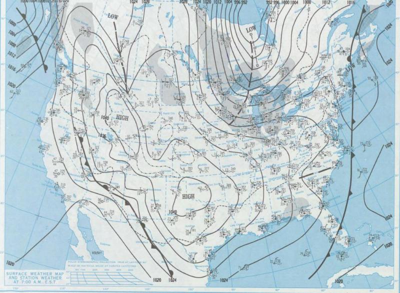
Surface Maps valid at 6AM CST
 |
 |
 |
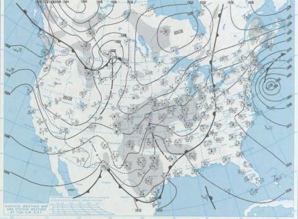 |
| October 28 | October 29 | October 30 | October 31 |
 |
 |
 |
|
| November 1 | November 2 | November 3 |
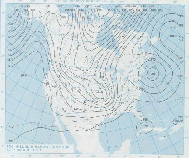
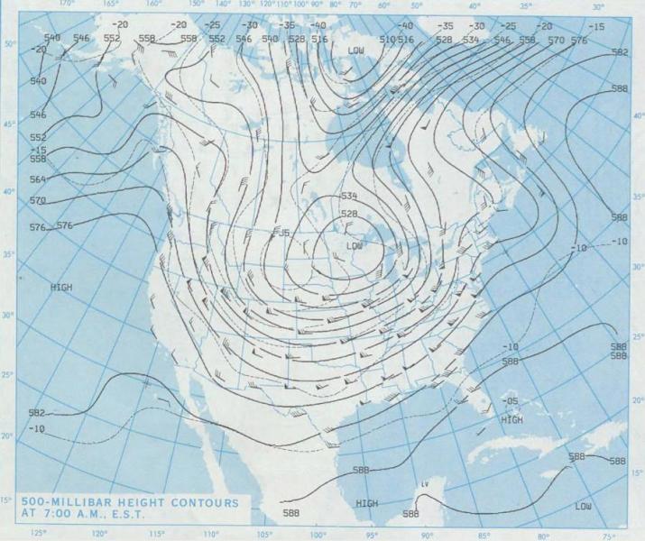
500MB Maps valid at 7AM CST
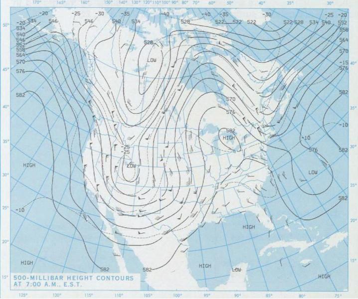 |
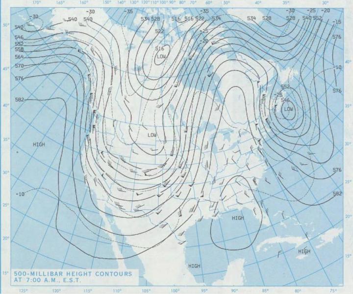 |
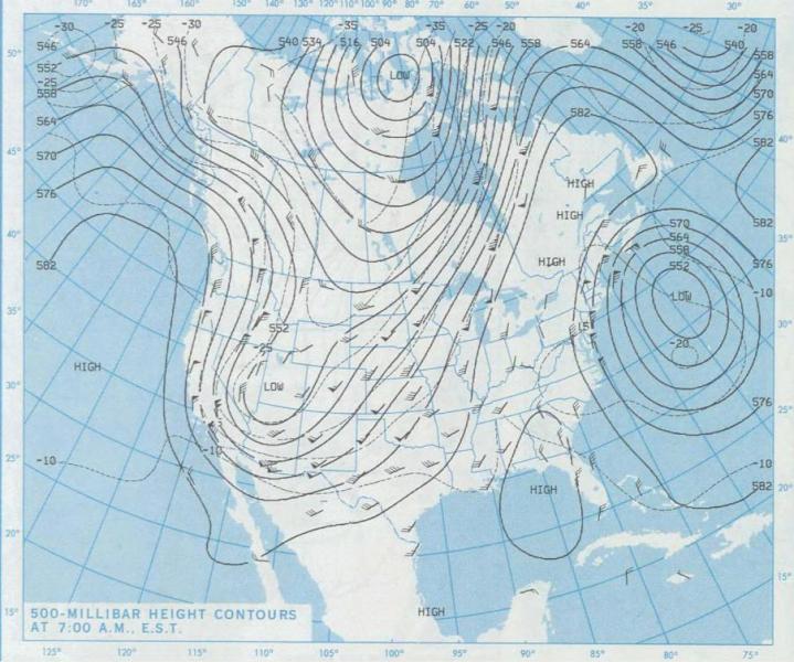 |
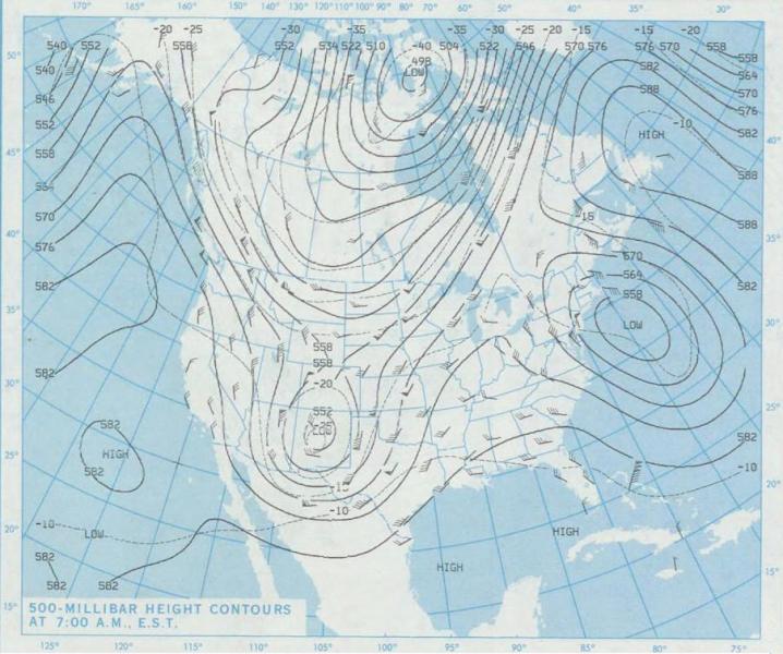 |
| October 28 | October 29 | October 30 | October 31 |
 |
 |
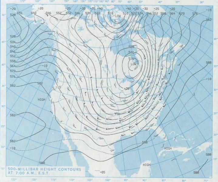 |
|
| November 1 | November 2 | November 3 |
Maps courtesy NOAA Central Library Data Imaging Project
30th Anniversary of the 1991 Halloween Blizzard
Believe it or not, but it has been 30 years since one of the largest snowstorms on record hit the Northland. Thirty years later it still stands as the biggest single day snowfall in Duluth (24.1" 11/01/91) along with the single largest storm in Duluth with a total accumulation of 36.9". That 36.9" was also the state record, but that was quickly beaten by a storm that dropped 46.5" of snow January 6-8, 1994, at Wolf Ridge ELC near Finland, Minnesota. That record still stands today. This storm sticks in every Minnesotan's (and western Wisconsinite's) memory and almost everyone that lived here at the time as some sort of story about it. While had it not occurred over the Halloween holiday, it still would have been a memorable storm, but that fact that it started on Halloween helped elevate it to an event that sticks in people's minds. Aside from the significant amount of snow and blizzard-conditions that occurred, this event was notable for how early in the season it occurred, coupled with above normal temperatures in the 50s and 60s just two days before it hit. Below are some of the recollections we have received from people that experienced the storm. If you would like to share your story with us, you can send it to nws.duluth@noaa.gov. Thanks to all that submitted stories!
Recollections
One of busiest days ever at the Spooner Middle School office with parents calling and calling for busses to get students home safely. Staff didn’t leave until all students were home safely. By the time we left school, I couldn’t even see where the highway was, but did make it home, very slowly. Will never forget that day. Think we ended up with 3’ of snow by time it ended a couple days later. - Jacki P.
I left work at 4:30 taking my usual Proctor express bus. The bus got stuck on Highland at Oneota Cemetery. Finally some of us got off and started walking up the hill. A guy in a pickup truck let us ride in the back from the intersection of Skyline. I got home after 6:00 to find that my then 16 year old daughter had taken my car to take her younger sister trick or treating! They did make it home safely. - Carol S.
I remember working until 6:00 the night it started. Had quite a bit of snow when I headed home. Had trick or treaters coming on snowmobiles. Didn't leave the house until Monday morning. So much snow in the driveway it took forever to move. - Dawn R.
My plow guy hit the driveway four times. Lost his transmission on the third round for his clients; borrowed a buddy's truck for the final round. Tough night for plow services. I was "essential personnel" -- made it the eight miles to downtown; toughest part was getting from my dead-end city street past the county "gift" across the street's entry to the county road. I kept the parking receipt -- figured it was more fun to have the memorabilia than putting in a reimbursement for the 10 bucks. Still have it. - Dan Y.
I was 4, trick or treating in Gilbert with my mom. I was Minnie Mouse that year. We only went to a few houses because we couldn’t see! Between my Minnie mask and the snow, I didn’t last long. That’s all I remember. - Holly E.
We got pizza in Superior delivered on a late 1970s Scorpion snowmobile. - Tracy and Tim W.
My son was born that evening at St. Mary’s in Duluth. It was a very memorable few days as when we returned home, our house outside of Superior was buried in 30 some inches of snow. I will never forget the Halloween Blizzard, but needless to say my son doesn‘t remember it. Hard to believe it was 30 years ago. - Susan V.
I was working. We doubled up in the few 4x4 squads we had and some 4wd from public works. We kept getting stuck anyway. The wind would almost take you off your feet when you got out to do anything. In the morning I was dropped off a block and a half from my house and had to "swim" through waist deep snow to get home. - Marcia B.
We were living on the Central Hillside then, just below the Coppertop. I spent those four days looking down on the white city and smiling. Our car was parked on 8th St. and all that showed was the red ribbon tied to the antenna. Shoveled it out, but that didn't make any difference as the plows didn't get to our street for four days. Spent a lot of time sledding down our hill with the kids. The avenues were great sledding hills for days. (Photos below) - Greg and Sharon D.
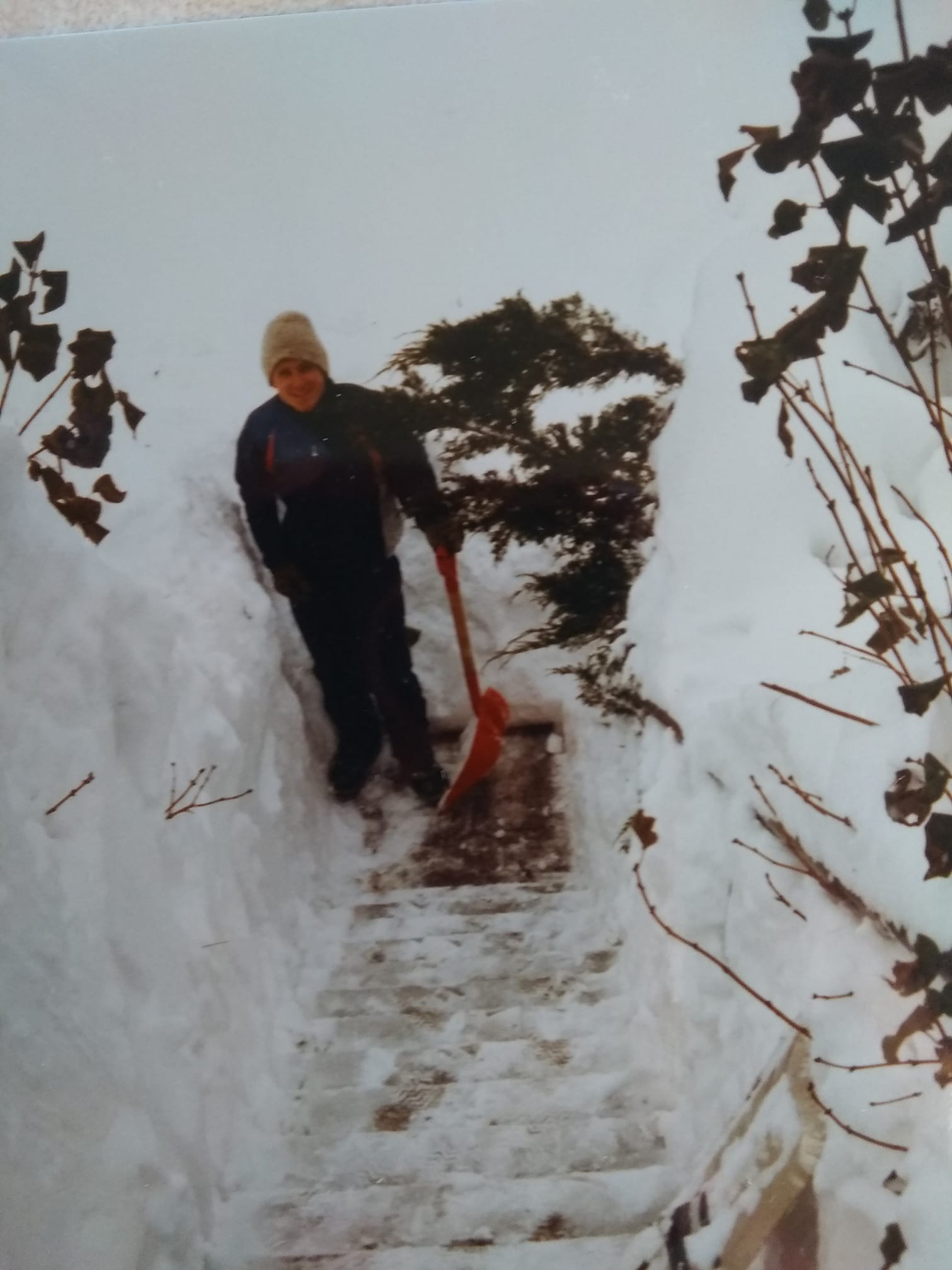
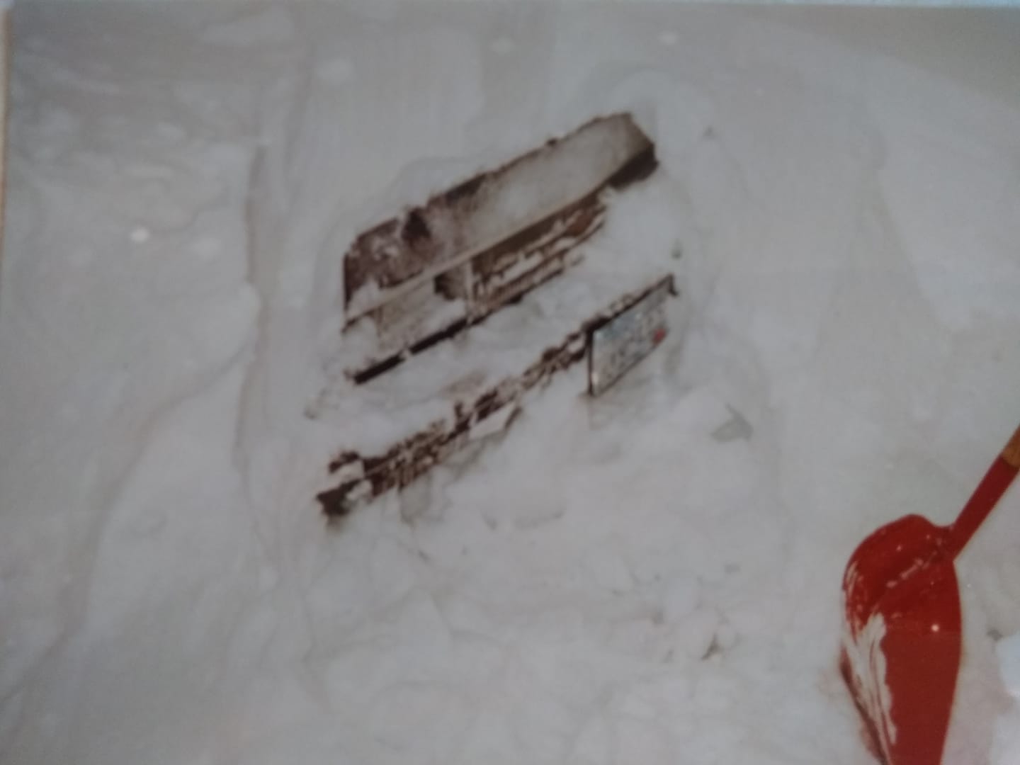
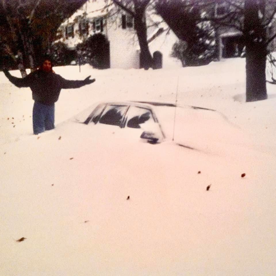
This was my car after the storm. I remember walking in the middle of London Road to pick up food. Cars could not drive on the road yet. (Photo below) - David K.
I remember the blizzard well. It was warm enough not to need a jacket in the afternoon. We went to a costume party and didn't seem to notice until we were handed a shovel to get our truck out of the snowbank. The next day we had someone shovel us out enough to get to the garage for the snowblower. Took us most of the day to get the driveway passable. When we had finally got our driveway cleared the plow guy came by and left us a 4 ft pile to get through to get to the road. Our more than awesome mailman took his truck with a plow and plowed out all the mailboxes on the route as well as a few driveway openings. He was amazing. - Christy H.
Was living in west Eveleth at the time. My husband had just bought a brand new sled. The night of the storm we were headed to Texas to visit my sister. Roads were awful. Asked my husband if he wanted to spend the night in the Cites. Good thing we didn't!! By the time we got back from Texas, all the snow was gone. My husband was disappointed!! He had to wait to ride his new sled! - Jamie I.
Took my kids on their sled across the street to the senior home to trick or treat. On our way back home, no sled tracks to be found! - Carole F.
I worked at Fond-du-Luth at the time and dressed up like Ariel-the little mermaid. On the way home, I stopped at Holiday in Proctor to gas up my car. When I tried to get back in the car the doors had frozen shut. I was stuck all night in my costume. I asked my friend who was working If I should go sit by the Shicken of the sea as a display. lol. Luckily my neighbor came in in the morning and was able to get my door open. - Tammy S.
My daughter had the cutest cowgirl costume. I guess I wouldn’t let her wear it unless it was under her snowsuit. (She still talks about that Halloween) Traumatizing!! They trick-or-treated to 1 house and turned back. - Mary R.
Rode a snowmobile back and forth to work for a week. I worked at a snowmobile dealership and we were busy! - Earle H.
I hope it never happens again! I remember taking my daughter into town to go trick-or-treating with her friends. The evening was cut short because of heavy snow and miserable visibility. The two plus miles to home was scary. My husband had been out of town for work and was stranded at the airport in the Twin Cities. When it was done, there was anywhere from 3 to 5 feet of snow drifted in our 500 foot driveway. We were snowed in and had to wait an extra day or two for my husband to get home. He buried his four wheel drive truck just a few feet into the driveway and had to walk in, crawl might be a better word. It took him forever to open it up with the tractor and bucket. - Mary H.
I was in 7th grade. Our high school was remodeling and it was the first year that another high school joined ours. We had to walk to separate outside buildings in that snow. We could get lost as they couldn't even get it plowed for us. - Heather M.
There was a freezing rain that started around noon that day and Esko dismissed their classes early so the boys ran home across the street from the school. Trick-or-Treat started early that year. The snow was building fast and I realized that there would be no kids coming to the door that year so the boys and I brought the candy and pumpkins to the garage with lights on and kept shoveling to make sure dad, who worked at Fraser Shipyards, could get his truck in the garage. Every car picking up their kids pulled over and the kids ran to the garage and we handed out all of the candy and even went in and grabbed pop to hand out until dad got home. We were lucky to have a wood stove in the basement so our home was warm and we were happy everyone had a treat. Deer hunting that year was another story. - Bobbi P.
 |
Media use of NWS Web News Stories is encouraged! Please acknowledge the NWS as the source of any news information accessed from this site. |
|

