A storm and trailing cold front will continue to slowly move through the Gulf Coast and Southeast U.S. through this weekend with widespread rain showers and isolated thunderstorms. A fast-moving clipper storm may bring several inches of snow to the north-central Plains, Midwest, eastern Great Lakes, and Northeast regions this weekend. Read More >
Overview
|
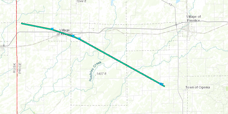
During the evening of June 14, 2019, thunderstorms moved over Price County. One of the storms produced a tornado which began 4.1 miles west-northwest of Kennan and ended 2.2 miles west-northwest of Ogema. Sporadic damage was reported which is consistent with an EF-0 tornado with peak winds of 65-75 mph. The tornado was well-documented with numerous photos and videos during it`s life. We extend our thanks to Price County Emergency Management for their considerable assistance in documenting and assessing this tornado event. |
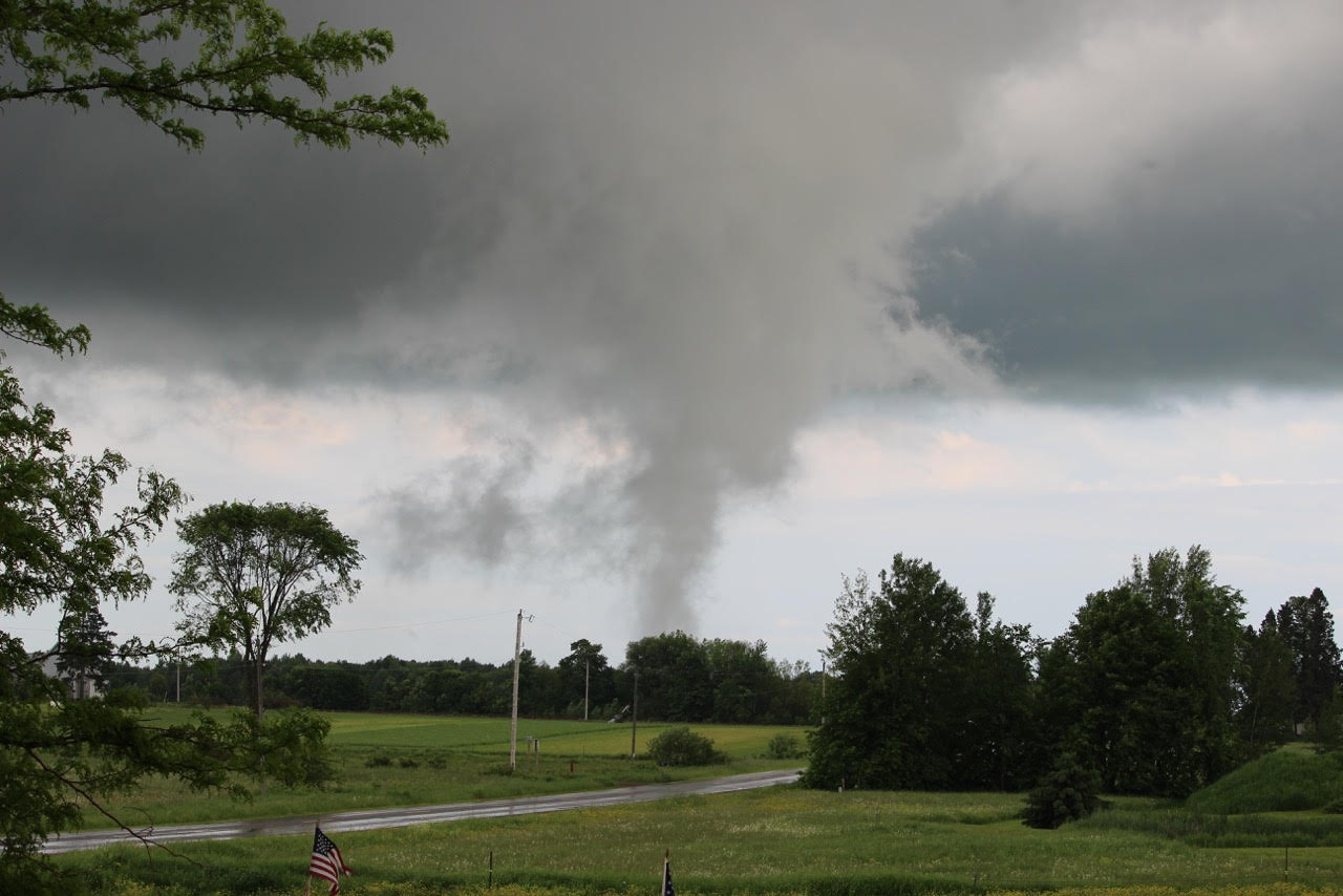
(Photo Courtesy Becky Kempen ) |
Tornado:
|
Tornado - Kennan/Ogema, WI
|
||||||||||||||||
The Enhanced Fujita (EF) Scale classifies tornadoes into the following categories:
| EF0 Weak 65-85 mph |
EF1 Moderate 86-110 mph |
EF2 Significant 111-135 mph |
EF3 Severe 136-165 mph |
EF4 Extreme 166-200 mph |
EF5 Catastrophic 200+ mph |
 |
|||||
Photos & Video
Coming Soon
 |
|
The Kennan-Ogema Tornado seen from north of Kennan, WI. (Photo Courtesy Becky Kempen ) |
Radar
Radar imagery from KDLH radar in Duluth, MN, which is approximately 105 miles away from where this tornado occurred.
| Radar Reflectivity Animation | Radar Velocity Animation |
Storm Reports
Individual damage reports used in the damage assessment are listed below. An interactive map with photos included (when available) can be found on the experimental NWS Damage Assessment Viewer.
..TIME...   ...EVENT...      ...CITY LOCATION...     ...LAT.LON...
..DATE...   ....MAG....      ..COUNTY LOCATION..ST.. ...SOURCE....
            ..REMARKS..

0654 PM     TORNADO          4 WNW KENNAN            45.55N 90.67W
06/14/2019                   PRICE              WI   EMERGENCY MNGR

            START POINT OF KENNAN/OGEMA TORNADO. TIME
            ESTIMATED FROM RADAR.

0702 PM     TORNADO          1 NW KENNAN             45.54N 90.60W
06/14/2019                   PRICE              WI   EMERGENCY MNGR

            SEVERAL HARDWOOD TREE BRANCHES BROKEN. TIME
            ESTIMATED FROM RADAR.

0709 PM     TORNADO          1 WSW CATAWBA           45.53N 90.55W
06/14/2019                   PRICE              WI   LAW ENFORCEMENT

            CHICKEN COOP FLIPPED OVER AND TIN ROOF BLOWN
            OFF SHED. TIME ESTIMATED FROM RADAR. THIS
            REPORT CORRECTS PREVIOUS THUNDERSTORM WIND
            DAMAGE REPORT FROM 1 WSW CATAWBA.

0711 PM     TORNADO          1 S CATAWBA             45.53N 90.53W
06/14/2019                   PRICE              WI   LAW ENFORCEMENT

            SHINGLES BLOWN OFF ROOF AND TREES DOWN. TIME
            ESTIMATED FROM RADAR. THIS REPORT CORRECTS
            PREVIOUS THUNDERSTORM WIND DAMAGE REPORT
            FROM 1 S CATAWBA.

0734 PM     TORNADO          3 WNW OGEMA             45.46N 90.35W
06/14/2019                   PRICE              WI   EMERGENCY MNGR

            SOFTWOOD TREE AND SEVERAL BRANCHES BROKEN.
            TIME ESTIMATED FROM RADAR.

0735 PM     TORNADO          3 W OGEMA               45.45N 90.35W
06/14/2019                   PRICE              WI   EMERGENCY MNGR

            DAMAGE TO OVERHEAD DOORS ON OUTBUILDING.
            PUSHED A SHED OFF FOUNDATION AND REMOVED
            SHINGLES. ROLLED TRACTOR ONTO ITS SIDE. TIME
            ESTIMATED FROM RADAR.

0736 PM     TORNADO          2 W OGEMA               45.44N 90.34W
06/14/2019                   PRICE              WI   EMERGENCY MNGR

            END POINT FOR KENNAN/OGEMA TORNADO. TIME
            ESTIMATED FROM RADAR.
Environment
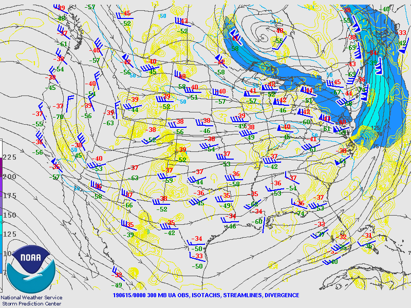
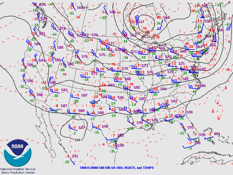
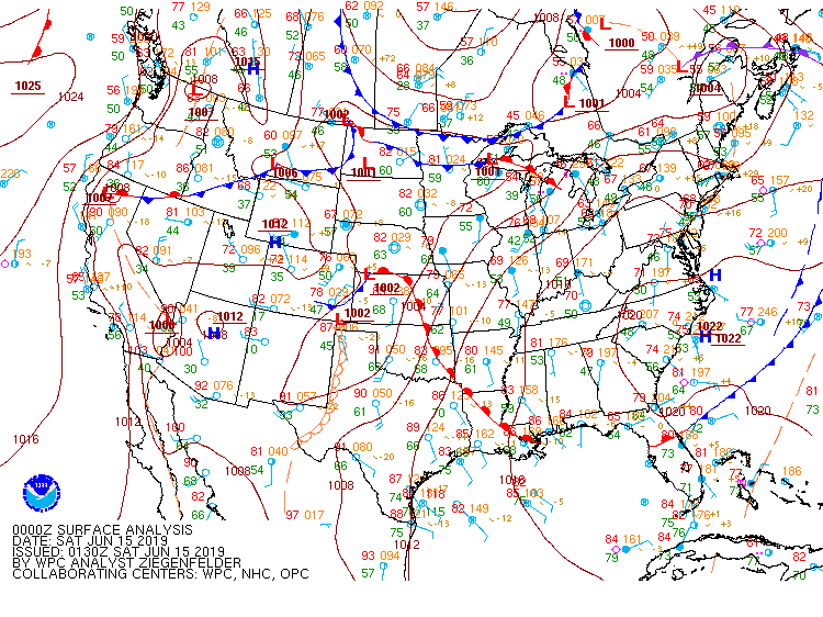
All maps are valid at 00:00 UTC June 15 (7:00pm CDT June 14), which is centered on the time of the tornado. On the synoptic scale, an upper low was located over northwest Ontario. Upper level flow was out of the northwest across Price County, with mid level winds from the west-northwest.
 |
 |
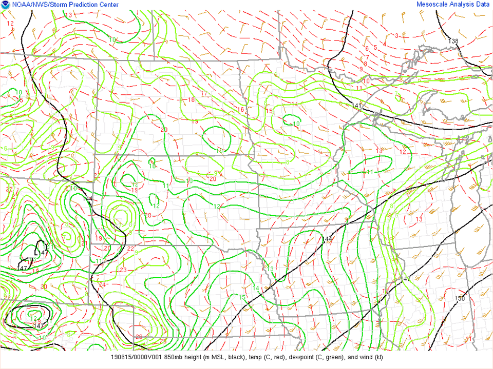 |
| Figure 1: 250 mb chart | Figure 2: 500 mb chart | Figure 3: 850 mb chart |
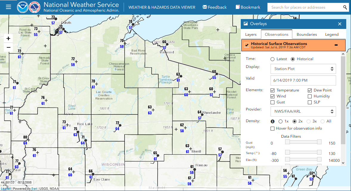
At the surface, an east-west oriented warm frontal boundary was analyzed across northern Wisconsin. Along and south of this warm front, dew point values (blue numbers on Figure 5) were in the low to mid 60s, which lower (drier) dew points were observed to the north of the front. Surface-based instability values were analyzed to be around 500-1000 j/kg in Price county, which around 50 j/kg CIN for surface-based parcels.
 |
 |
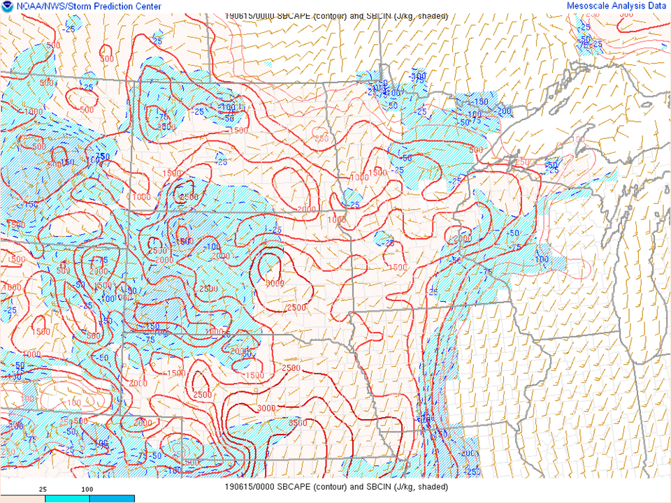 |
| Figure 4: Surface Analysis | Figure 5: Surface Observations (ASOS/AWOS Only) [Interactive Map] | Figure 6: Surface-based CAPE |
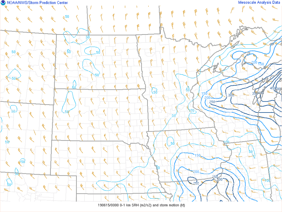
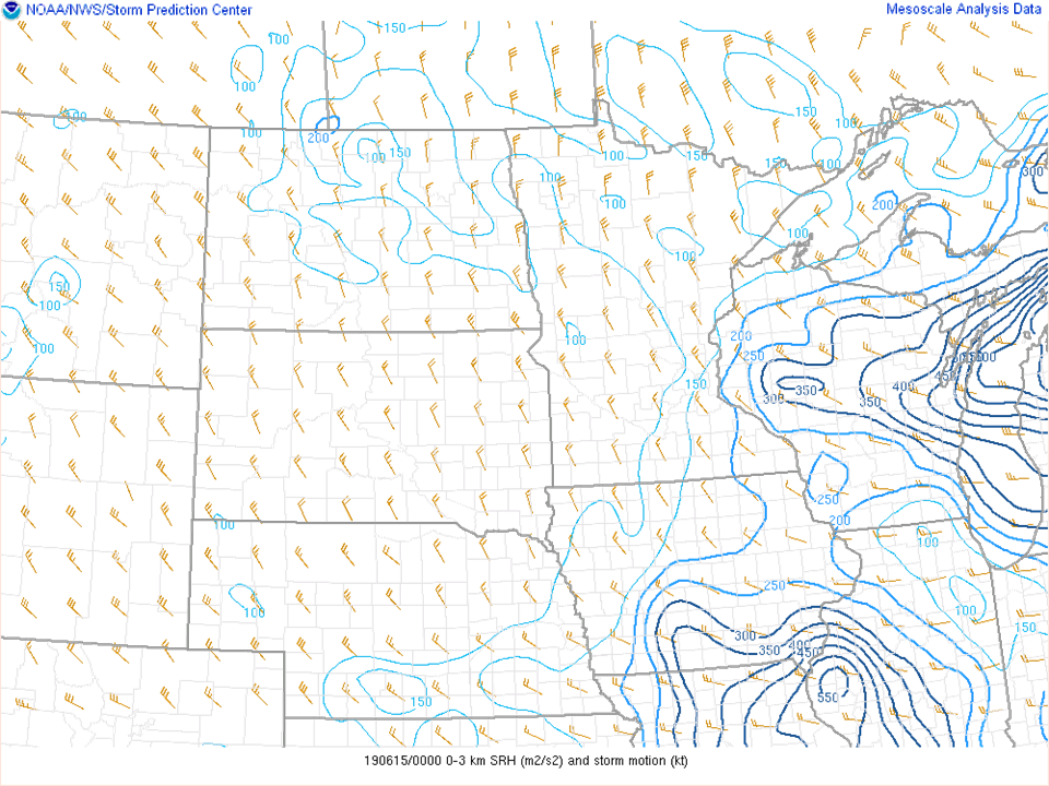
Low level helicity (a measure of the change in wind speed and turning with height) was critical to developing a tornado in this environment. Effective storm-relative helicity values were analyzed to be around 200-300 m2/s2 at the time of the tornado, which is fairly favorable for rotating supercells. While the instability (CAPE) values were not extreme, combined with the helicity values and "short" nature of the storm, a so-called mini supercell was able to develop and produce a tornado. This was an otherwise very weak storm with only occasional lightning and radar echo tops around 30-40 kft (compared to most strong to severe storms that have echo tops around or exceeding 50 kft).
 |
 |
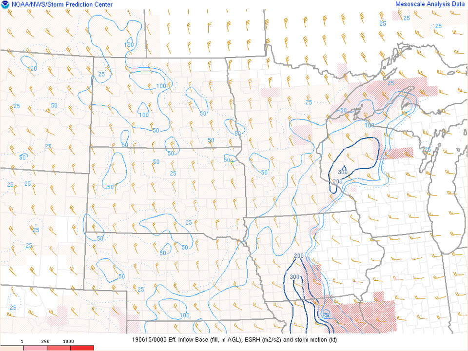 |
| Figure 7: 0-1 km SRH | Figure 8: 0-3 km SRH | Figure 9: Effective SRH and Storm Motion |
 |
Media use of NWS Web News Stories is encouraged! Please acknowledge the NWS as the source of any news information accessed from this site. |
|