A heat wave over the Southwest will intensify late week, peaking and expanding into the Intermountain West and northern High Plains this weekend. Severe thunderstorms and heavy rain are expected over portions of the Plains and Mississippi Valley tonight, which will shift to parts of the Upper Midwest and mid-Mississippi Valley Friday. Monsoonal showers and flooding persist in the Desert Southwest. Read More >
Overview
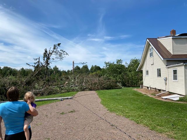
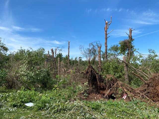
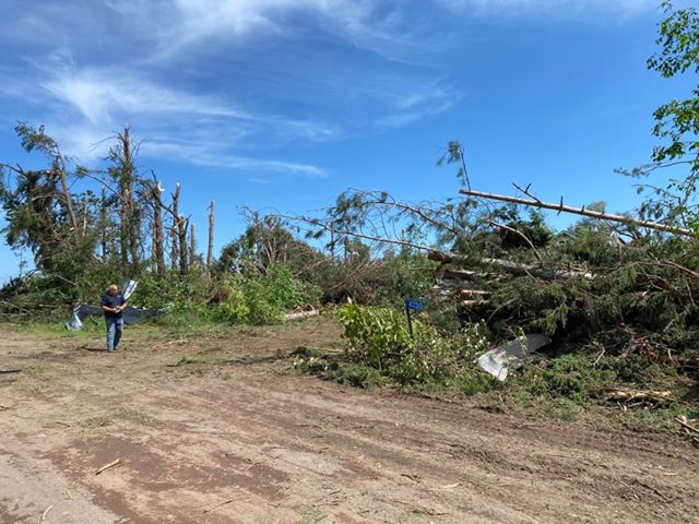
Late in the afternoon on Friday, August 14, scattered strong to severe thunderstorms tracked east across Minnesota. While the storms initially produced small hail, wind damage, and minor flooding as they tracked across the Iron Range, a cluster of storms rapidly matured and surged eastward after moving across Lake Mille Lacs, producing a few brief tornadoes as they approached the Interstate 35 corridor. These tornadoes were all brief in duration and short in length, with the strongest tornado producing high-end EF-1 damage west of Moose Lake. The line of storms then took on a bowing structure and produced widespread wind damage along and east of the I-35 corridor, especially in Pine and Carlton counties. While some of this damage was initially suspected to be possibly from a tornado, further inspection of ground, aerial, and satellite imagery did not find sufficient evidence that a tornado occurred east of I-35. NWS appreciates the numerous photos and videos of damage that assisted greatly in the assessment of this storm damage from spotters, Carlton County Emergency Management, and the public.
Wind
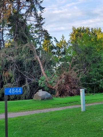
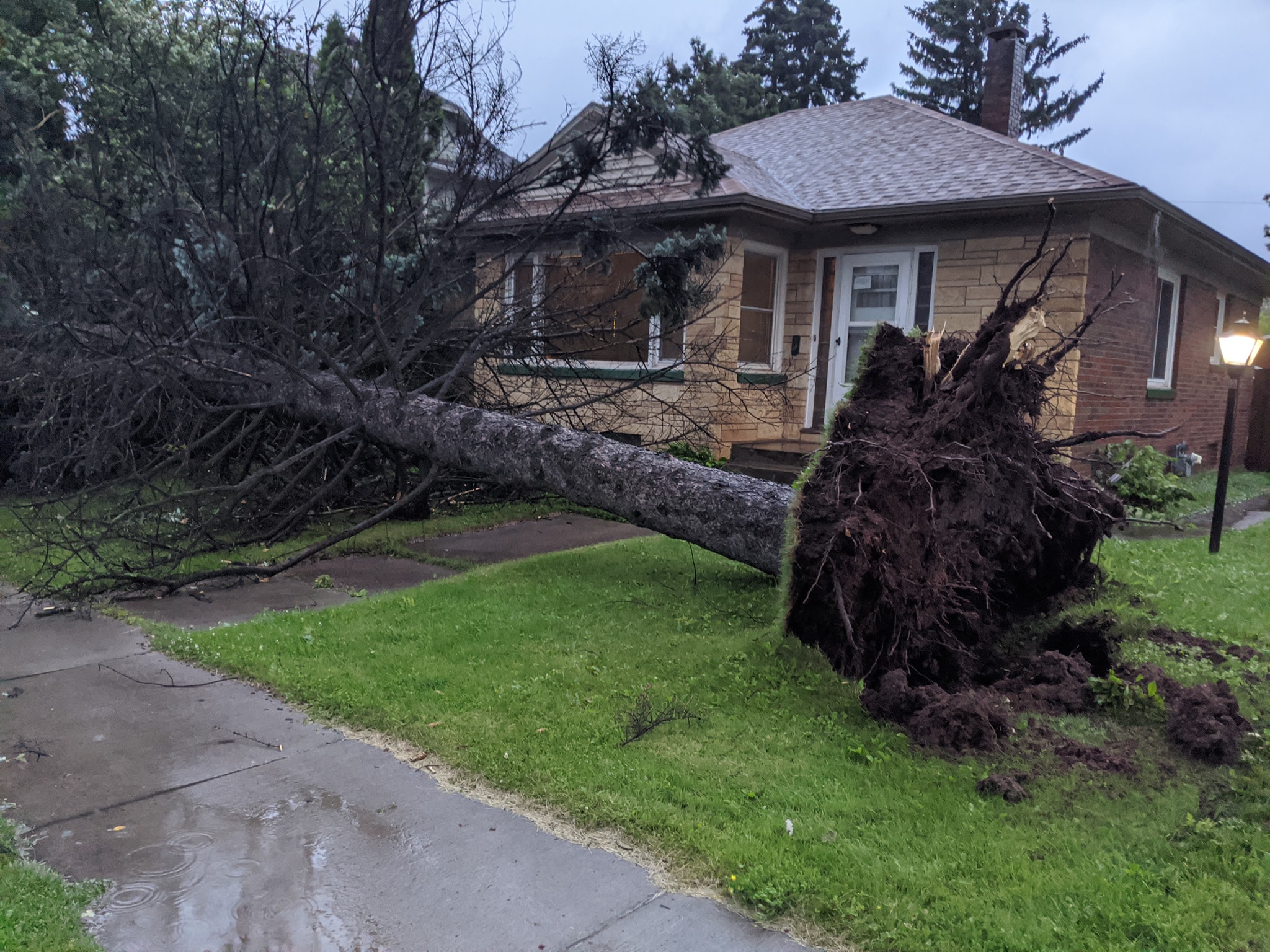
The bulk of the damage from this event was from strong, damaging winds that fell numerous trees. There was a few reports of hail, but nothing larger than the size of a nickel.
 |
 |
 |
 |
|
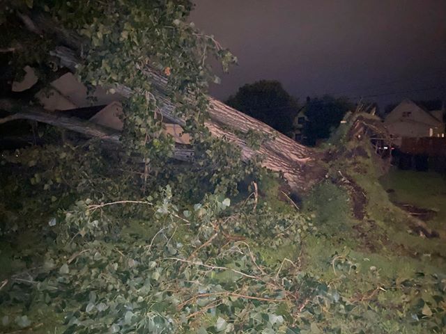
Large tree down in Superior, WI (courtesy of Lylia Stroup) |
Large tree down in Superior, WI (courtesy of Dan Hanger) |
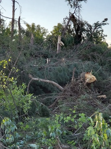
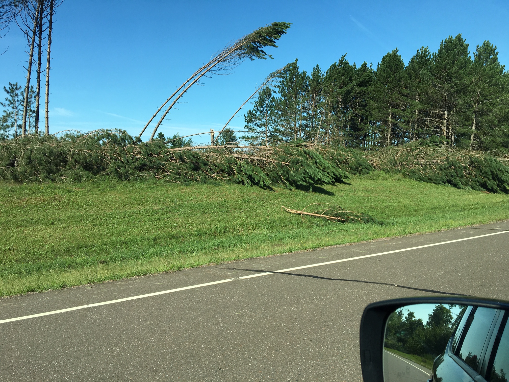
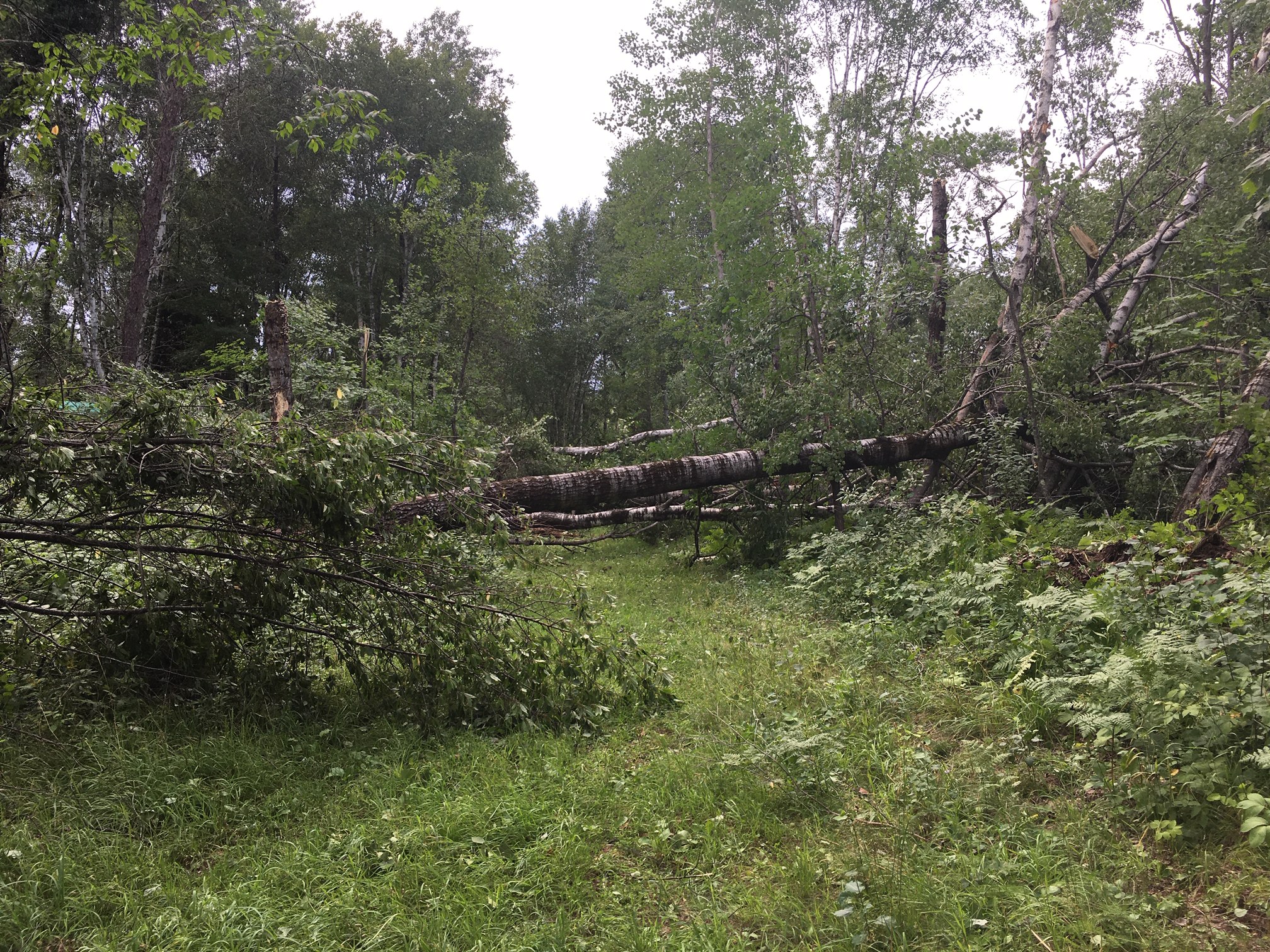
Numerous trees down west of Kerrick in northern |
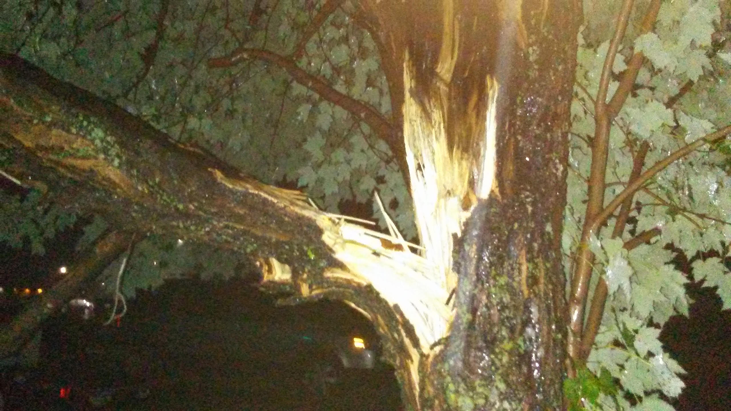
Tree snapped in Siren, WI (courtesy of Michael Clark) |
 |
 |
 |
 |
|
Container train blown over at the Duluth Port Terminal (courtesy David Schauer) |
Tree damage a few miles west of Kerrick, MN |
Tree damage a few miles west of Kerrick, MN |
Tree damage a few miles west of Kerrick, MN |
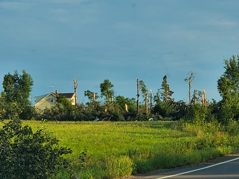
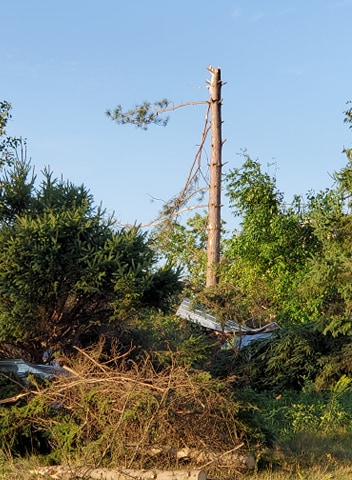
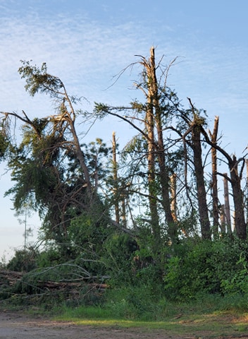
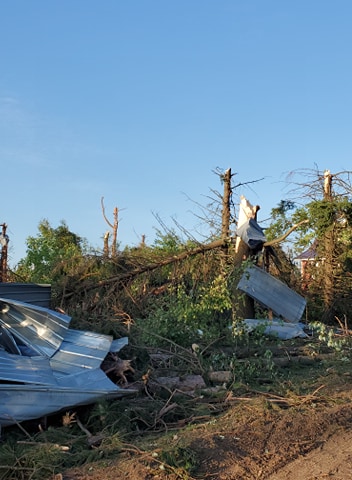
Tornadoes
|
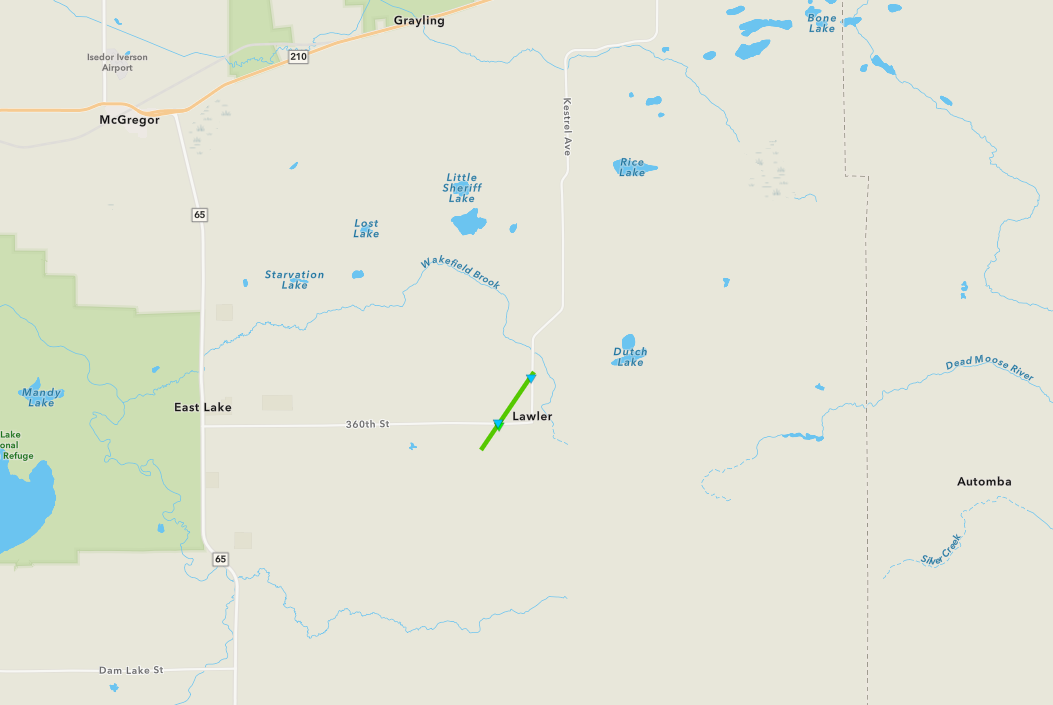
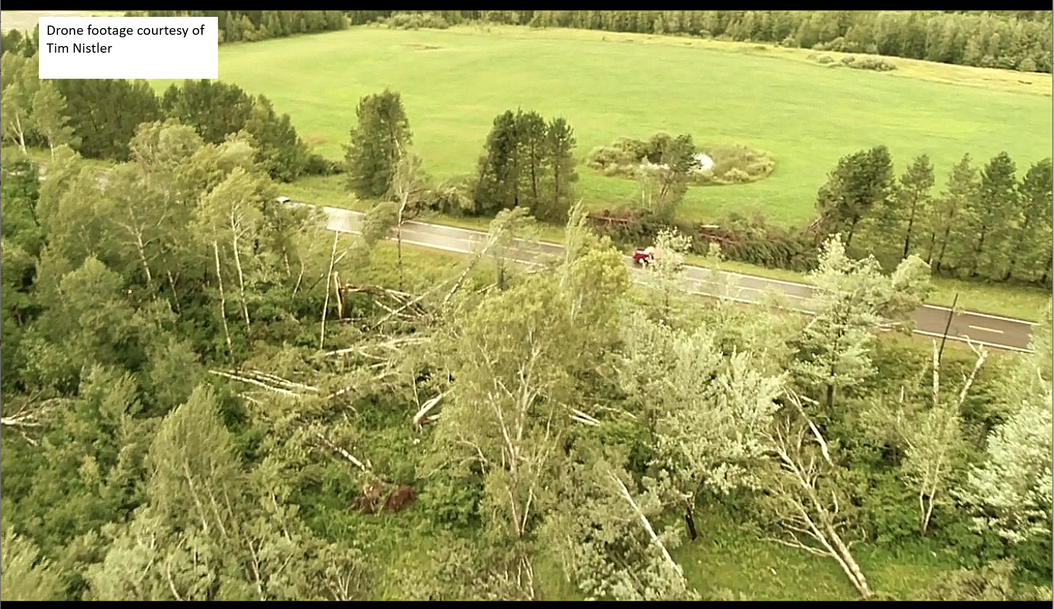
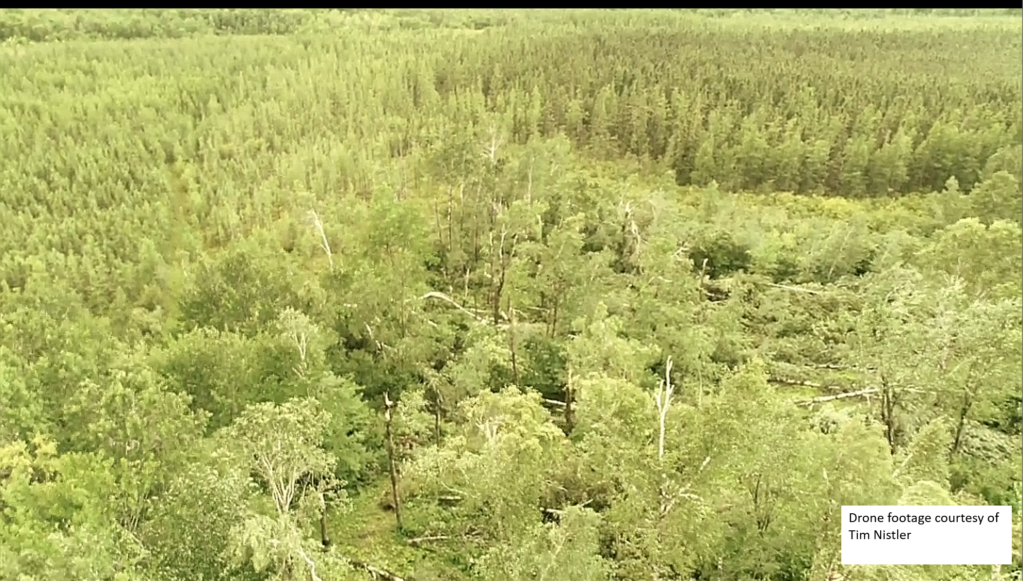
Tornado - Lawler, MN
|
||||||||||||||||
Video - Lawler Tornado (Tim Nistler video) |
||||||||||||||||
|
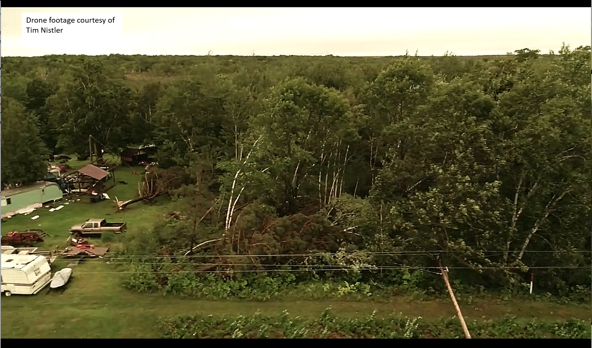
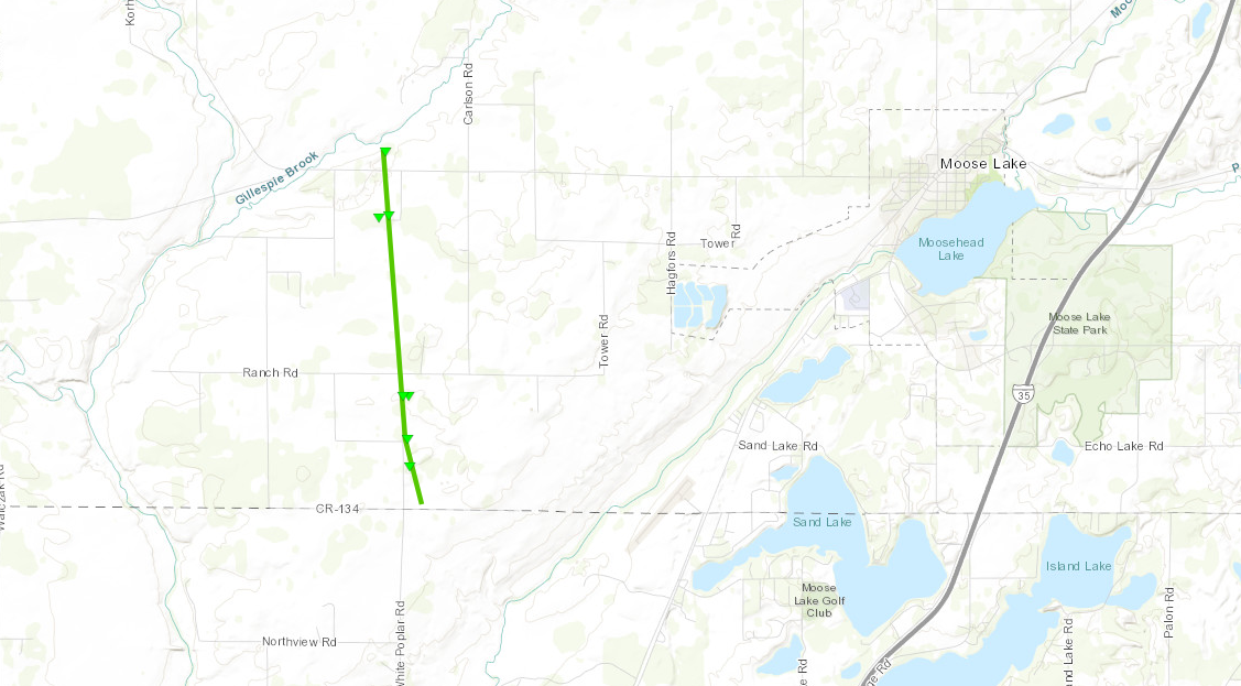
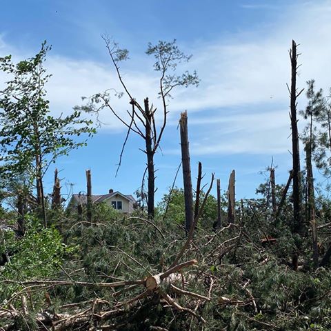
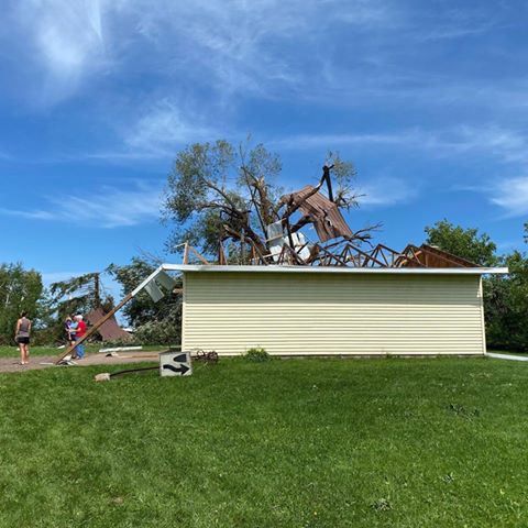
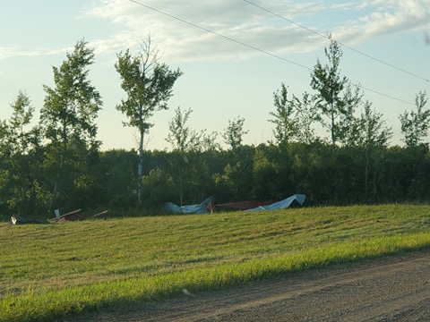
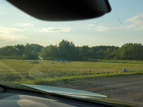
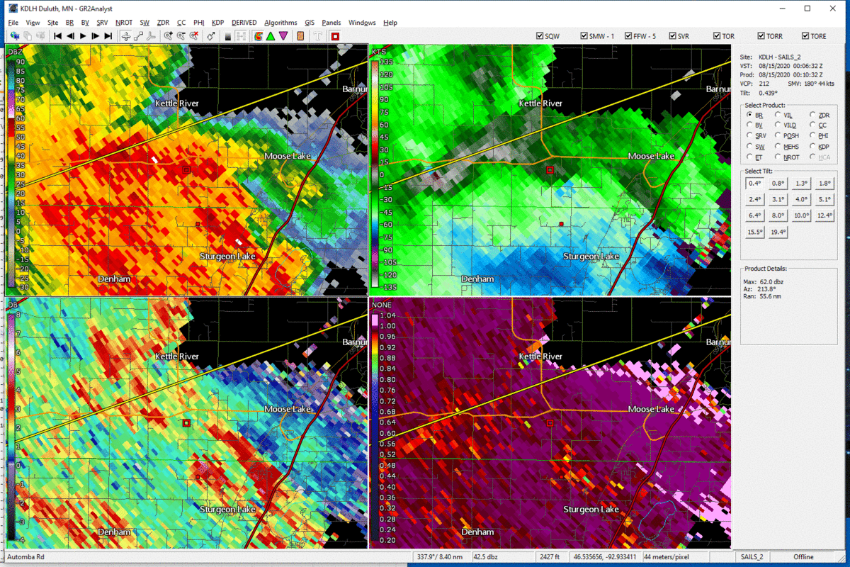
Tornado - West of Moose Lake, MN
|
||||||||||||||||||||||||||||||||||||||||||||
|
||||||||||||||||||||||||||||||||||||||||||||
|
Tornado - Automba, MN
|
||||||||||||||||
The Enhanced Fujita (EF) Scale classifies tornadoes into the following categories:
| EF0 Weak 65-85 mph |
EF1 Moderate 86-110 mph |
EF2 Significant 111-135 mph |
EF3 Severe 136-165 mph |
EF4 Extreme 166-200 mph |
EF5 Catastrophic 200+ mph |
 |
|||||
Flooding
We received some reports of flash flooding, especially in Itasca and St. Louis counties. There were reports of localized flooding in the city of Grand Rapids, with a culvert washed out on County Road 69 near Birch Drive south of Marble. There was also water over roadways in parts of Keewatin and Nashwauk.
 |
 |
||
|
Road flooding southeast of Grand Rapids, MN |
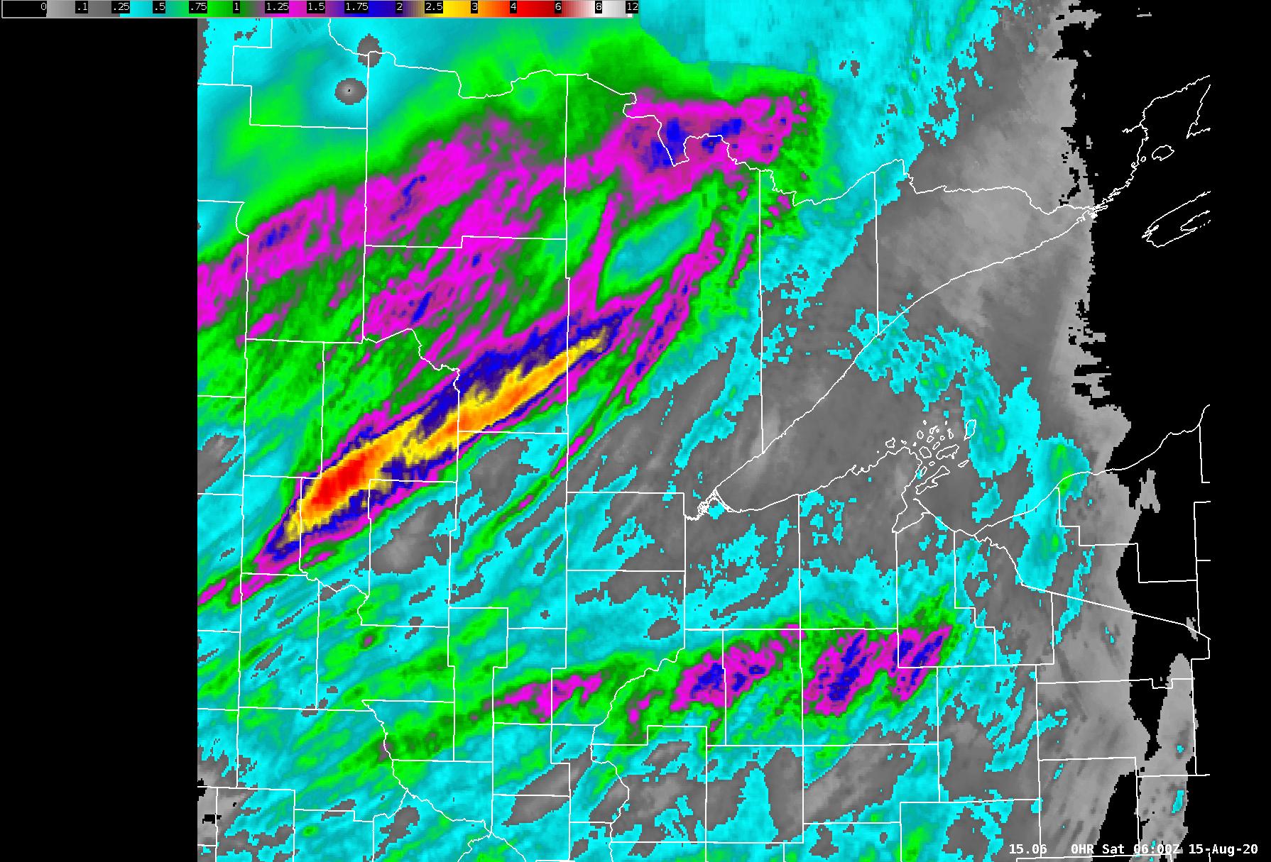
Radar estimated rainfall |
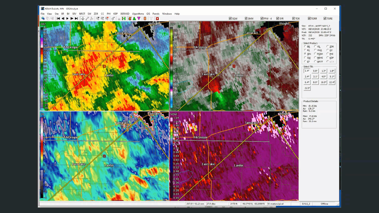
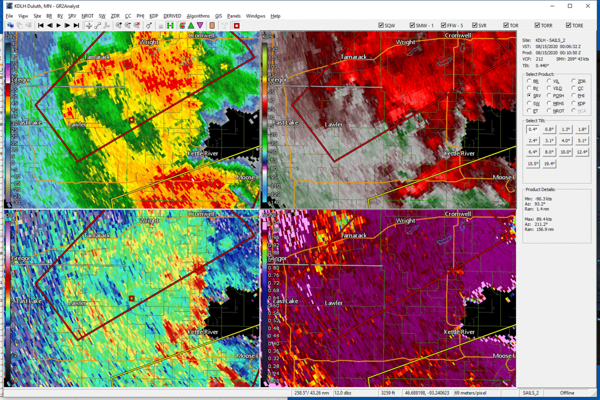
Radar
 |
 |
| Radar loop of the Lawler Tornado. Note the TDS in the CC at lower right. | Radar loop of a TDS and rotation near Automba. No damage reports were received in this area. |
 |
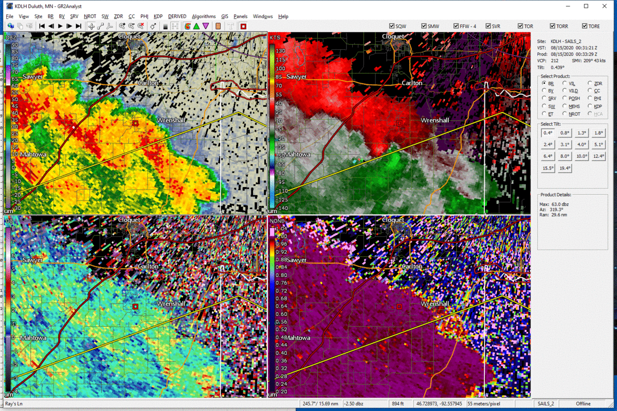 |
| A weak TDS was observed on radar near Moose Lake. | Another TDS was observed on radar near Scotts Corner. |
Storm Reports
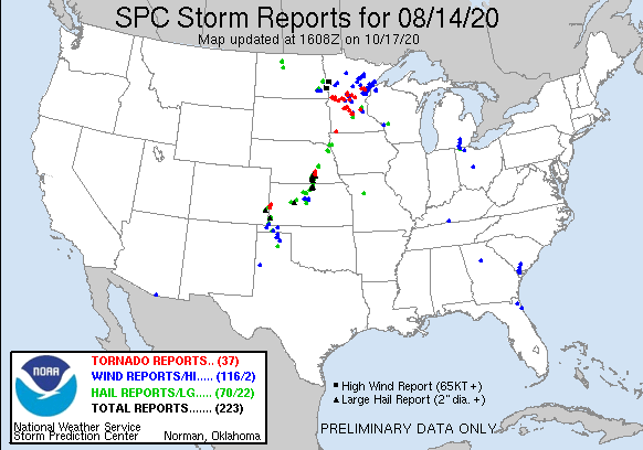
Click the image above for Storm Reports from around the country.
View a Local Storm Reports map here: http://www.mesonet.agron.iastate.edu/lsr/#DLH/202008142233/202008151645/0100.
PRELIMINARY LOCAL STORM REPORT...SUMMARY
NATIONAL WEATHER SERVICE DULUTH MN
355 PM CDT MON AUG 17 2020
..TIME... ...EVENT... ...CITY LOCATION... ...LAT.LON...
..DATE... ....MAG.... ..COUNTY LOCATION..ST.. ...SOURCE....
..REMARKS..
0533 PM TSTM WND DMG 2 NNW CROSSLAKE 46.71N 94.11W
08/14/2020 CROW WING MN LAW ENFORCEMENT
SEVERAL DOWNED TREES.
0546 PM TSTM WND DMG 1 S FIFTY LAKES 46.73N 94.09W
08/14/2020 CROW WING MN PUBLIC
ABOUT 15 ACRES WORTH OF TREES WERE DOWNED OF
HEAVILY DAMAGED ON THE SOUTH SIDE OF FIFTY
LAKES. PHOTOS SHOW ALL TREES DOWNED OR BENT
OVER IN THE SAME DIRECTION. TIME ESTIMATED
BY RADAR.
0609 PM TSTM WND GST 3 WNW WOODROW 46.40N 94.13W
08/14/2020 M40 MPH CROW WING MN ASOS
ASOS STATION KBRD BRAINERD AIRPORT.
0613 PM FUNNEL CLOUD CROSBY 46.49N 93.96W
08/14/2020 CROW WING MN TRAINED SPOTTER
FUNNEL CLOUD OBSERVED BY TRAINED SPOTTER.
0615 PM TSTM WND GST 2 E AITKIN 46.53N 93.67W
08/14/2020 M44 MPH AITKIN MN AWOS
AWOS STATION KAIT AITKIN AIRPORT.
0620 PM FLASH FLOOD 7 S DAYS HIGH LANDING 47.16N 93.78W
08/14/2020 CASS MN LAW ENFORCEMENT
CASS COUNTY SHERIFFS OFFICE CALLED TO REPORT
FLOODING ACROSS THE ROAD ON STATE RD 6 NEAR
WILLOW LAKE.
0622 PM TSTM WND DMG 4 SSE LIBBY 46.74N 93.29W
08/14/2020 AITKIN MN LAW ENFORCEMENT
DELAYED REPORT. MANY TREES DOWN, DOCKS
DAMAGED, AND POWERLINES DOWN DUE TO WIND IN
THE BIG SANDY LAKE AREA. LOCATION
APPROXIMATE. TIME ESTIMATED BY RADAR.
0623 PM HAIL 1 SSW GRAND RAPIDS 47.22N 93.53W
08/14/2020 E0.88 INCH ITASCA MN TRAINED SPOTTER
0623 PM HAIL 1 SW GRAND RAPIDS 47.22N 93.54W
08/14/2020 E0.88 INCH ITASCA MN PUBLIC
0624 PM HAIL 1 NW GRAND RAPIDS 47.24N 93.53W
08/14/2020 M0.25 INCH ITASCA MN TRAINED SPOTTER
0625 PM HAIL 1 SW GRAND RAPIDS 47.22N 93.54W
08/14/2020 E0.25 INCH ITASCA MN PUBLIC
SPORADIC PEA SIZED HAIL. REPORT SENT IN VIA
SOCIAL MEDIA.
0632 PM FUNNEL CLOUD 1 WNW CALUMET 47.32N 93.28W
08/14/2020 ITASCA MN TRAINED SPOTTER
POSSIBLE FUNNEL CLOUD WITHIN A ROTATING
SHELF CLOUD. DIFFICULT TO SEE IF FUNNEL WAS
TOUCHING THE GROUND SINCE IT APPEARED TO BE
RAIN WRAPPED. LOCATION APPROXIMATE...SPOTTER
REPORTED SEEING THIS FUNNEL NEAR MARBLE ON
US-169.
0634 PM TSTM WND DMG 3 SSE BOVEY 47.25N 93.38W
08/14/2020 ITASCA MN AMATEUR RADIO
SEVERAL TREES REPORTED DOWN AT THE TROUT
LAKE CAMPGROUND NEAR GRAND RAPIDS.
0639 PM TSTM WND DMG 1 N LA PRAIRIE 47.24N 93.49W
08/14/2020 ITASCA MN LAW ENFORCEMENT
STATE PATROL REPORTS THAT 2 FEET OF WATER
WAS COVERING THE ROAD ON 169 NEAR GLENWOOD
DRIVE. ROAD WILL BE SHUT DOWN.
0639 PM FLASH FLOOD 1 N LA PRAIRIE 47.24N 93.49W
08/14/2020 ITASCA MN LAW ENFORCEMENT
STATE PATROL REPORTS THAT 2 FEET OF WATER
WAS COVERING THE ROAD ON 169 NEAR GLENWOOD
DRIVE. ROAD WILL BE SHUT DOWN.
0642 PM TSTM WND DMG HILL CITY 46.99N 93.60W
08/14/2020 AITKIN MN LAW ENFORCEMENT
DELAYED REPORT. SOME MINOR TREE DAMAGE IN
THE HILL CITY AREA. LOCATION APPROXIMATE.
TIME ESTIMATED BY RADAR.
0648 PM TSTM WND DMG 8 ESE MCGRATH 46.22N 93.12W
08/14/2020 AITKIN MN LAW ENFORCEMENT
DELAYED REPORT. DOCKS FLIPPED OVER NEAR
GIESE DUE TO STRONG WINDS. LOCATION
APPROXIMATE. TIME ESTIMATED BY RADAR.
0657 PM FLASH FLOOD 1 NE GRAND RAPIDS 47.24N 93.51W
08/14/2020 ITASCA MN PUBLIC
LOCALIZED FLOODING IN THE CITY OF GRAND
RAPIDS. NOTABLE LOCATIONS INCLUDE ACE
HARDWARE ON 5TH STREET AND OTHER DOWNTOWN
BUSINESS LOCATIONS.
0657 PM TSTM WND DMG 1 NE GRAND RAPIDS 47.24N 93.51W
08/14/2020 ITASCA MN PUBLIC
LOCALIZED FLOODING IN THE CITY OF GRAND
RAPIDS. NOTABLE LOCATIONS INCLUDE ACE
HARDWARE ON 5TH STREET AND OTHER DOWNTOWN
BUSINESS LOCATIONS.
0658 PM TORNADO 1 W LAWLER 46.53N 93.18W
08/14/2020 AITKIN MN PUBLIC
DELAYED REPORT. DRONE VIDEO SHOWED TORNADO
DAMAGE TO A STAND OF TREES. SEVERAL TREES
WERE BROKEN APPROXIMATELY 25 TO 30 FT AGL
WITH SEVERAL MORE TREES UPROOTED. DAMAGE IS
CONSISTENT WITH LOW-END EF-1 TORNADO WITH
MAX WIND GUSTS OF 85 TO 90 MPH. TIME
ESTIMATED FROM RADAR.
0658 PM TSTM WND DMG 1 W LAWLER 46.54N 93.19W
08/14/2020 AITKIN MN TRAINED SPOTTER
MULTIPLE TREES AND POWER LINES DOWN. TIME
ESTIMATED BY RADAR.
0658 PM TSTM WND DMG 5 SW FINLAYSON 46.15N 92.99W
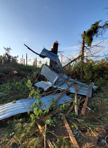
08/14/2020 PINE MN PUBLIC
DELAYED REPORT. PART OF A METAL ROOF WAS
PEELED OFF OF A HOUSE WITH ADDITIONAL DAMAGE
TO A BARN NEAR THE INTERSECTION OF GRONINGEN
ROAD AND FOX ROAD DUE TO STRONG WINDS. TIME
ESTIMATED BY RADAR.
0700 PM TSTM WND DMG 3 NNW SANDSTONE 46.16N 92.90W
08/14/2020 PINE MN PUBLIC
TREE BLOWN DOWN OVER DRIVEWAY. TIME
ESTIMATED BY RADAR. ALSO REPORTED 1.2 INCHES
OF TOTAL RAINFALL.
0700 PM TSTM WND DMG LAWLER 46.54N 93.17W
08/14/2020 AITKIN MN PUBLIC
MULTIPLE TREES AND POWER LINES DOWN. TIME
ESTIMATED BY RADAR.
0700 PM TSTM WND DMG 1 ESE FINLAYSON 46.20N 92.91W
08/14/2020 PINE MN PUBLIC
TREES WERE DOWN IN FINLAYSON. MOSTLY DEAD
BIRCH AND DEAD TAMARACK BUT A FEW LIVE
POPPLE TREES WERE UPROOTED AS WELL.
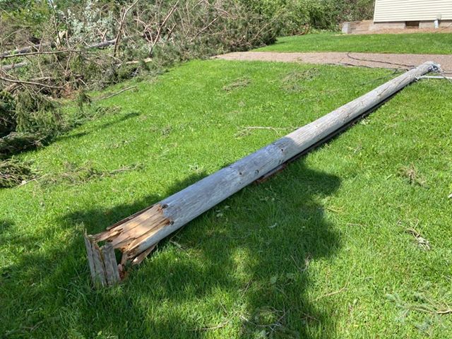
0701 PM TORNADO 1 N LAWLER 46.55N 93.17W
08/14/2020 AITKIN MN PUBLIC
DELAYED REPORT. DRONE VIDEO SHOWED TORNADO
DAMAGE TO A STAND OF TREES AND A FEW
OUTBUILDINGS. SEVERAL MATURE SOFTWOOD TREES
WERE BROKEN A FEW FEET ABOVE GROUND AND
SEVERAL MORE WERE UPROOTED. AN OUTBUILDING
HAD A GARAGE DOOR DISHED IN. AN ELECTRICAL
POLE WAS BROKEN A FEW FEET ABOVE GROUND
LEVEL. DAMAGE IS CONSISTENT WITH HIGH-END
EF-0 TORNADO WITH MAX WIND GUSTS OF 75 TO 85
MPH. TIME ESTIMATED FROM RADAR.
0702 PM TSTM WND DMG SANDSTONE 46.13N 92.86W
08/14/2020 PINE MN PUBLIC
SEVERAL 3-5 INCH DIAMETER TREES REPORTED
BROKEN. TIME ESTIMATED BY RADAR.
0704 PM TSTM WND DMG HIBBING 47.41N 92.94W
08/14/2020 ST. LOUIS MN PUBLIC
A FEW TREES WERE DOWN IN HIBBING WITH AT
LEAST ONE PARTIALLY BLOCKING A STREET.
0704 PM TSTM WND DMG 2 ENE SANDSTONE 46.13N 92.83W
08/14/2020 PINE MN PUBLIC
TEN INCH DIAMETER TREE BROKEN. TIME
ESTIMATED BY RADAR.
0704 PM TSTM WND DMG 2 SSW WILLOW RIVER 46.29N 92.85W
08/14/2020 PINE MN PUBLIC
TREES WERE FALLING ALONG MN-61 AS SPOTTER
WAS DRIVING SOUTH BETWEEN WILLOW RIVER AND
RUTLEDGE. TIME ESTIMATED BY RADAR.
0705 PM TSTM WND DMG 2 SSE HIBBING 47.37N 92.93W
08/14/2020 ST. LOUIS MN PUBLIC
A POWER LINE WAS DOWN AND LAYING ACROSS PART
OF TOWNLINE ROAD. TIME ESTIMATED BY RADAR.
0706 PM FLOOD LAWLER 46.54N 93.17W
08/14/2020 AITKIN MN LAW ENFORCEMENT
DELAYED REPORT. A FEW CULVERTS WASHED OUT
DUE TO FLOODING FROM HEAVY RAIN. LOCATION
APPROXIMATE. TIME ESTIMATED BY RADAR.
0710 PM TSTM WND DMG 1 E STURGEON LAKE 46.38N 92.81W
08/14/2020 PINE MN PUBLIC
MULTIPLE TREES DOWN WITHIN THE CITY OF
STURGEON LAKE. TIME ESTIMATED BY RADAR.
0714 PM TSTM WND DMG 2 WNW KERRICK 46.35N 92.63W
08/14/2020 PINE MN PUBLIC
A TREE FELL ONTO A CABIN WITH LOTS OF
ADDITIONAL TREE DAMAGE AROUND THE PROPERTY
AS WELL. TIME ESTIMATED BY RADAR.
0715 PM TSTM WND GST 2 E HINCKLEY 46.02N 92.90W
08/14/2020 M49 MPH PINE MN AWOS
AWOS STATION K04W HINCKLEY AIRPORT.
0716 PM TSTM WND DMG CHISHOLM 47.49N 92.88W
08/14/2020 ST. LOUIS MN FIRE DEPT/RESCUE
POWER LINES WERE IN THE TREES WITH
SMOLDERING LIMBS. TIME ESTIMATED FROM RADAR.
0717 PM TSTM WND DMG 4 W MOOSE LAKE 46.44N 92.84W
08/14/2020 CARLTON MN PUBLIC
REPORTS OF STRUCTURES DAMAGED BETWEEN
HIGHWAY 27 AND E COUNTY ROAD 134,
EAST-SOUTHEAST OF MOOSE LAKE, INCLUDING A
POLE SHED AND HOMESTEAD. TIME ESTIMATED BY
RADAR.
0718 PM TSTM WND DMG 3 NW MOOSE LAKE 46.48N 92.80W
08/14/2020 CARLTON MN PUBLIC
BARNS DOWN BETWEEN MOOSE LAKE AND KETTLE
RIVER. TIME ESTIMATED BY RADAR.
0720 PM TSTM WND DMG 3 NNW DUQUETTE 46.41N 92.58W
08/14/2020 PINE MN LAW ENFORCEMENT
TREE DOWN ON POWER LINE REPORTED VIA LAW
ENFORCEMENT. TIME ESTIMATED FROM RADAR.
0720 PM HAIL KEEWATIN 47.40N 93.08W
08/14/2020 M0.25 INCH ITASCA MN TRAINED SPOTTER
PEA SIZE HAIL AND TORRENTIAL RAINFALL WITH
2.99 INCHES OF RAINFALL ACCUMULATION.
0725 PM TSTM WND DMG 2 ESE MOOSE LAKE 46.44N 92.72W
08/14/2020 CARLTON MN LAW ENFORCEMENT
POWER LINE DOWN IN DITCH REPORTED VIA LAW
ENFORCEMENT. TIME ESTIMATED FROM RADAR.
0735 PM TSTM WND DMG 2 W SCOTTS CORNER 46.59N 92.46W
08/14/2020 CARLTON MN PUBLIC
CORRECTS PREVIOUS TSTM WND DMG REPORT FROM 2
W SCOTTS CORNER. OVER 100 TREES DOWN AT THE
LOCATION WITH THE TREES STACKED UP ON EACH
OTHER. DAMAGE MAY BE FROM A TORNADO. TIME
ESTIMATED BY RADAR.
0735 PM TSTM WND DMG 5 NE NEMADJI 46.52N 92.51W
08/14/2020 CARLTON MN PUBLIC
VIDEO SENT IN VIA SOCIAL MEDIA OF MULTIPLE
TREES UPROOTED. TIME ESTIMATED FROM RADAR.
0741 PM TSTM WND DMG 3 WSW FOND DU LAC 46.66N 92.33W
08/14/2020 CARLTON MN PUBLIC
A TREE WAS DOWN OVER THE ROADWAY IN JAY
COOKE STATE PARK. TIME ESTIMATED BY RADAR.
0741 PM TSTM WND GST 5 WNW SCOTTS CORNER 46.63N 92.53W
08/14/2020 M41 MPH CARLTON MN MESONET
MESONET STATION MN097 ATKINSON BRIDGE I-35
MILE POST 231.
0742 PM TSTM WND DMG 2 WSW SCOTTS CORNER 46.59N 92.47W
08/14/2020 CARLTON MN LAW ENFORCEMENT
POWER LINE DOWN AND GOING ACROSS THE HIGHWAY
REPORTED VIA LAW ENFORCEMENT. TIME ESTIMATED
FROM RADAR.
0745 PM TSTM WND DMG 2 NNW SCOTTS CORNER 46.63N 92.45W
08/14/2020 CARLTON MN LAW ENFORCEMENT
POWER LINE DOWN REPORTED VIA LAW
ENFORCEMENT.
0745 PM TSTM WND DMG 5 E MAHTOWA 46.56N 92.53W
08/14/2020 CARLTON MN LAW ENFORCEMENT
REPORT OF A A TREE DOWN ACROSS THE ROAD VIA
LAW ENFORCEMENT. TIME ESTIMATED FROM RADAR.
0745 PM TSTM WND DMG 1 W THOMSON 46.66N 92.40W
08/14/2020 CARLTON MN LAW ENFORCEMENT
PINE TREE DOWN ACROSS HIGHWAY 210 REPORTED
VIA LAW ENFORCEMENT. TIME ESTIMATED FROM
RADAR.
0747 PM TSTM WND DMG SUPERIOR 46.72N 92.10W
08/14/2020 DOUGLAS WI PUBLIC
A LARGE TREE WAS UPROOTED NEAR DULUTH CITY
HALL. A FEW OTHER REPORTS OF DOWNED TREES
AND BRANCHES WERE RECEIVED FROM THE CENTRAL
PART OF SUPERIOR AS WELL. TIME ESTIMATED BY
RADAR.
0750 PM FLASH FLOOD HIBBING 47.40N 92.94W
08/14/2020 ST. LOUIS MN LAW ENFORCEMENT
NUMEROUS REPORTS OF FLOODED ROADWAYS ALONG
US 169 AND MANY CITY STREETS IN HIBBING WERE
RECEIVED.
0752 PM TSTM WND DMG SUPERIOR 46.72N 92.09W
08/14/2020 DOUGLAS WI PUBLIC
LARGE TREE DOWN IN SUPERIOR. REPORT WITH
PICTURE RECEIVED VIA FACEBOOK. TIME
ESTIMATED BY RADAR.
0755 PM TSTM WND GST 2 WSW CLOQUET 46.70N 92.50W
08/14/2020 M46 MPH CARLTON MN AWOS
AWOS STATION KCOQ CLOQUET AIRPORT.
0757 PM TSTM WND DMG 2 SSE DULUTH 46.75N 92.10W
08/14/2020 ST. LOUIS MN PUBLIC
CORRECTS PREVIOUS TSTM WND DMG REPORT FROM 2
SSE DULUTH. A STRING OF LOADED DOUBLE STACK
CONTAINER RAILROAD CARS WERE BLOWN OVER ON
THE SOUTH SIDE OF THE DULUTH PORT TERMINAL.
0758 PM TSTM WND DMG 1 NW MUNGER 46.81N 92.35W
08/14/2020 ST. LOUIS MN FIRE DEPT/RESCUE
A TREE WAS DOWN ON A POWER LINE IN SOLWAY
TOWNSHIP. TIME ESTIMATED BY RADAR.
0758 PM TSTM WND DMG 1 NNW SUPERIOR 46.73N 92.09W
08/14/2020 DOUGLAS WI PUBLIC
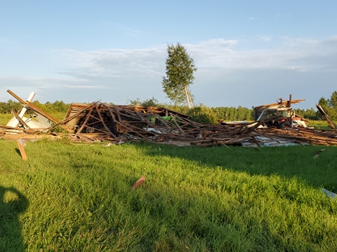
THE ROOF OF AN LARGE INDUSTRIAL BUILDING WAS
SEVERELY DAMAGED AND PARTIALLY BLOWN OFF.
REPORT AND PICTURE RECEIVED VIA FACEBOOK.
0800 PM FLASH FLOOD 4 SSE TACONITE 47.28N 93.32W
08/14/2020 ITASCA MN PUBLIC
A CULVERT WAS WASHED OUT ON COUNTY ROAD 69
NEAR BIRCH DRIVE SOUTH OF MARBLE AND CR 69
IS CLOSED.
0800 PM TSTM WND DMG 3 NE DULUTH 46.81N 92.07W
08/14/2020 ST. LOUIS MN PUBLIC
A TREE WAS DOWN ON A POWER LINE ON EAST 1ST
STREET AND THE TREE WAS ON FIRE. TIME
ESTIMATED BY RADAR.
0800 PM FLASH FLOOD KEEWATIN 47.40N 93.08W
08/14/2020 ITASCA MN TRAINED SPOTTER
REPORTS OF A MINIMUM OF 9 INCHES OF STANDING
WATER ON ROADWAYS IN PARTS OF KEEWATIN.
AROUND 12 INCHES OF WATER IN SOME SPOTS.
REPORTS OF FLOODING IN SEVERAL LOCATIONS IN
TOWN. SPOTTER REPORTED 3.96 INCHES OF RAIN.
0800 PM TSTM WND DMG LESTER PARK 46.84N 92.02W
08/14/2020 ST. LOUIS MN FIRE DEPT/RESCUE
A LARGE TREE WAS DOWN ON A POWER LINE ON
TIOGA STREET AND WAS ON FIRE. TIME ESTIMATED
BY RADAR.
0801 PM MARINE TSTM WIND 5 SE DULUTH 46.72N 92.05W
08/14/2020 M49 MPH ST. LOUIS MN AWOS
REPORTED BY THE KDYT DULUTH SKY HARBOR AWOS.
0802 PM TSTM WND DMG 1 N SOLON SPRINGS 46.36N 91.82W
08/14/2020 DOUGLAS WI PUBLIC
SEVERAL TREES DOWN, SOME AS LARGE AS 10
INCHES IN DIAMETER. TIME ESTIMATED BY RADAR.
0802 PM TSTM WND DMG 3 NNE DULUTH 46.82N 92.09W
08/14/2020 ST. LOUIS MN LAW ENFORCEMENT
REPORT OF METAL SHEETING DANGLING FROM A
BUILDING THAT COULD POSE A THREAT TO POWER
LINES.
0803 PM FLASH FLOOD NASHWAUK 47.38N 93.17W
08/14/2020 ITASCA MN LAW ENFORCEMENT
WATER TO A DEPTH OF 4 FEET WAS REPORTED OVER
PEARSON AVENUE IN NASHWAUK.
0803 PM TSTM WND GST 8 WNW MINONG 46.14N 91.98W
08/14/2020 M41 MPH WASHBURN WI MESONET
MESONET STATION MRZW3 MINONG RAWS.
0804 PM TSTM WND DMG SOLON SPRINGS 46.35N 91.82W
08/14/2020 DOUGLAS WI FIRE DEPT/RESCUE
A TREE WAS DOWN OVER A ROADWAY IN SOLON
SPRINGS. TIME ESTIMATED BY RADAR.
0805 PM TSTM WND GST 4 NE HERMANTOWN 46.85N 92.20W
08/14/2020 M41 MPH ST. LOUIS MN ASOS
ASOS STATION KDLH DULUTH INTERNATIONAL
AIRPORT.
0812 PM TSTM WND GST 1 SSE DULUTH 46.77N 92.11W
08/14/2020 M47 MPH ST. LOUIS MN MESONET
MESONET STATION MN082 DULUTH I-35 AND
GARFIELD RWIS.
0813 PM TSTM WND DMG 3 NW FRENCH RIVER 46.94N 91.94W
08/14/2020 ST. LOUIS MN FIRE DEPT/RESCUE
A TREE WAS LEANING ON A POWER LINE ALONG
LISMORE ROAD IN NORMANNA TOWNSHIP. TIME
ESTIMATED BY RADAR.
0822 PM TSTM WND DMG 1 N PALMERS 46.94N 91.85W
08/14/2020 ST. LOUIS MN FIRE DEPT/RESCUE
A TREE WAS DOWNED ONTO A POWER LINE ALONG
HOMESTEAD ROAD IN CLIFTON TOWNSHIP. TIME
ESTIMATED BY RADAR.
0851 PM FLASH FLOOD 5 S LA PRAIRIE 47.15N 93.50W
08/14/2020 ITASCA MN PUBLIC
FLOODING OVER ROADWAY WITH WATER UNDERMINING
THE BLACKTOP. REPORT AND PICTURE OF THE
FLOODING SENT IN VIA SOCIAL MEDIA.
0930 PM MARINE TSTM WIND 2 SE SILVER BAY 47.27N 91.25W
08/14/2020 M29 MPH LSZ143 MN MESONET
MESONET STATION SLVM5 2.0 SE SILVER BAY.
Environment
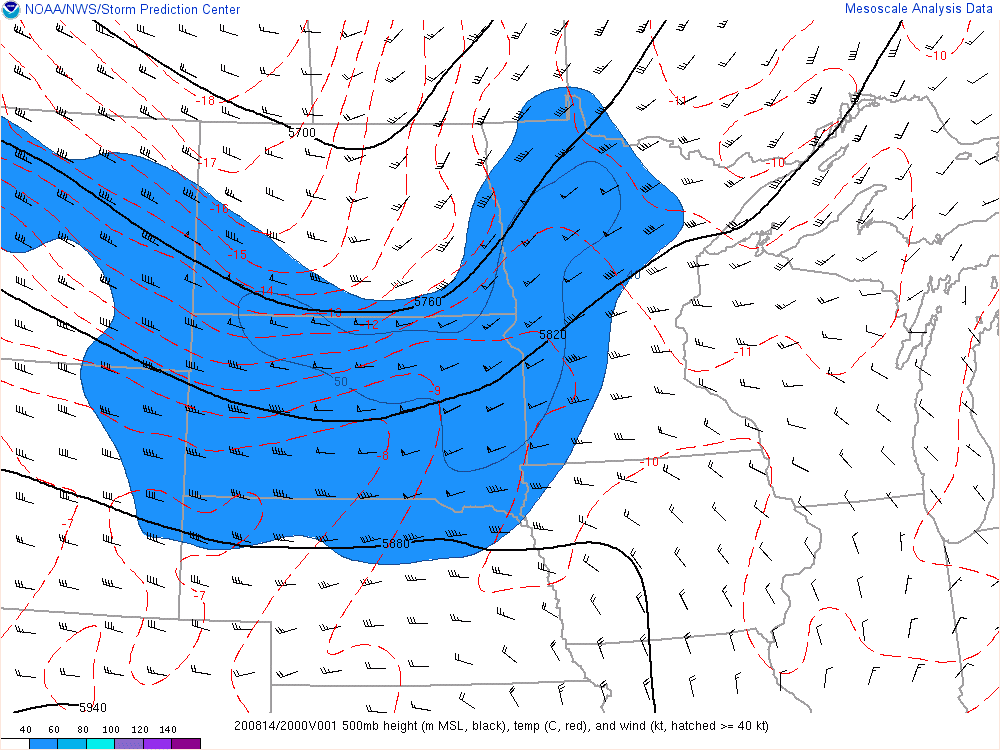
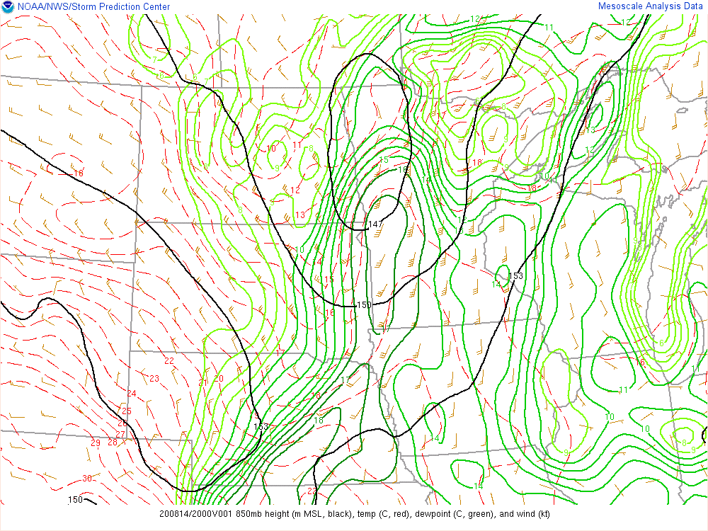
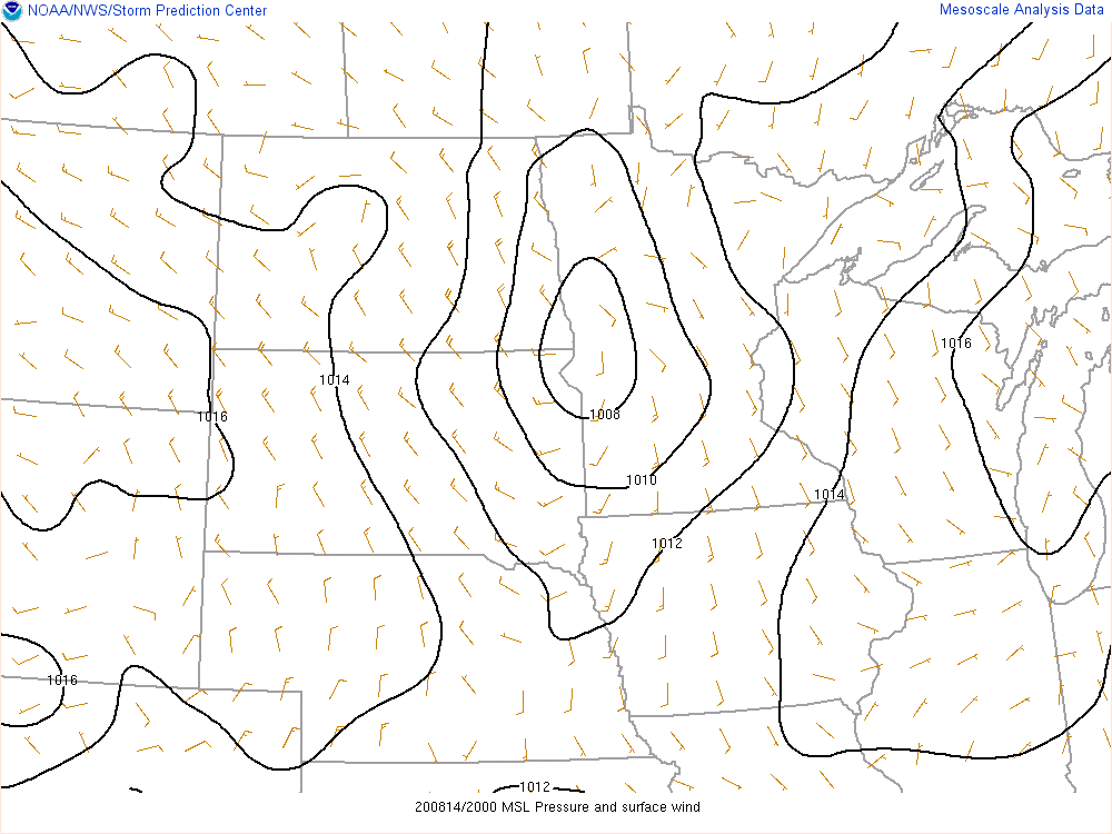
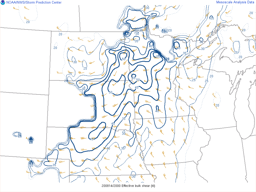
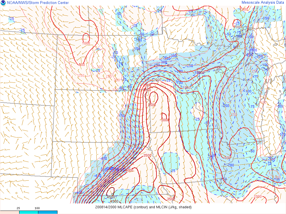
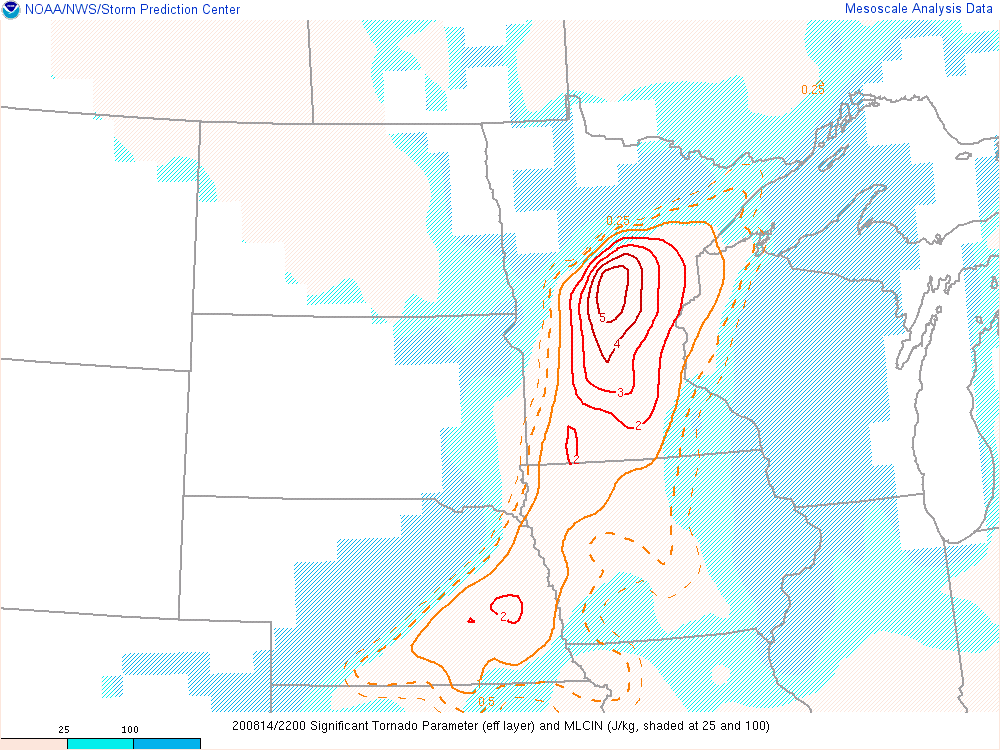
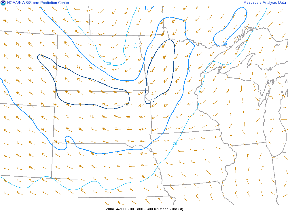
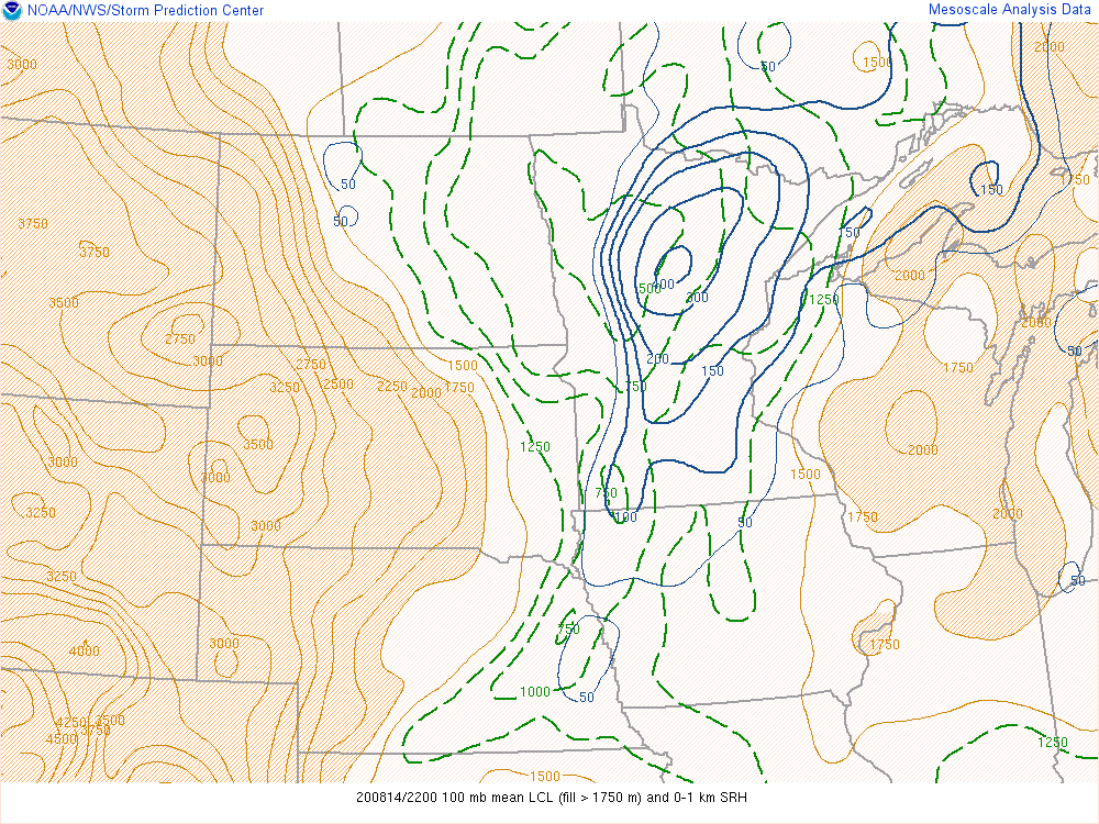
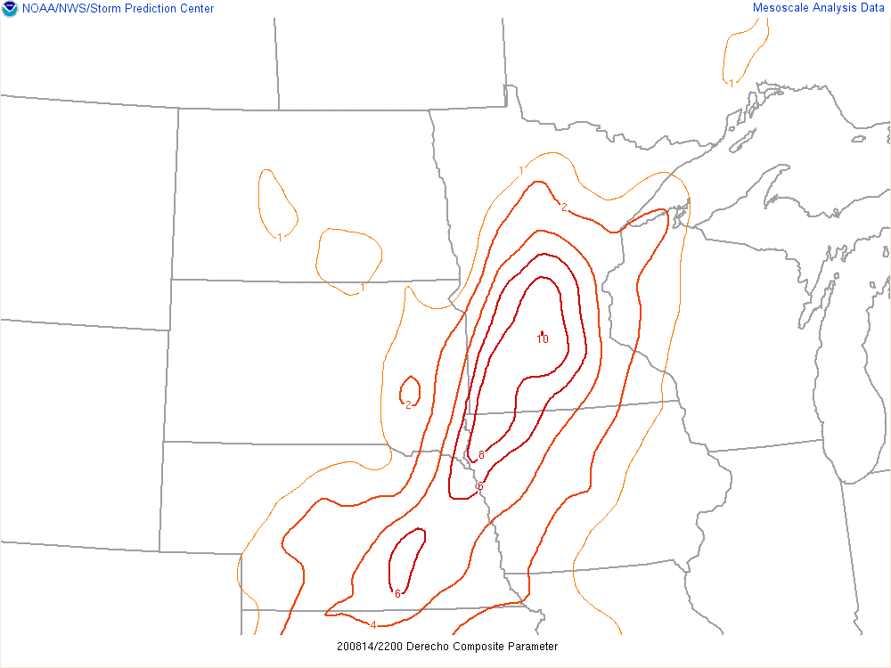
The environment was favorable for severe weather with a large upper-level trough and a strengthening mid-level jet curving into the region. A surface cold front, as seen by the wind shift in Figure 3, was the primary thunderstorm initiation mechanism. Deep-layer shear was very supportive of strong, convective updrafts with values ranging between 35 to 45 knots for most locations. Mixed-layer CAPE values were higher to the southwest of the region, but still in the 1000 to 2000 J/kg range across the south. LCLs and 0-1 km SRH were favorable for some low-level rotation, which ultimately became tornadic in some locations. Moreover, the Derecho Composite Parameter, which is used to gauge the support for strong winds, was quite high across our southwest.
 |
 |
 |
|
Figure 1: 500 mb map, with heights, temperatures, and wind velocities |
Figure 2: 850 mb map, with heights, temperatures, dew points, and wind velocities |
Figure 3: Mean Sea Level Pressure |
Near-storm environment:
 |
 |
 |
|
Figure 4: Effective Bulk Shear (2000 UTC) |
Figure 5: MLCAPE (2000 UTC) |
Figure 6: SigTor Parameter (2200 UTC) |
 |
 |
 |
|
Figure 7: 850-300 mb mean wind (2000 UTC) |
Figure 8: LCL Height and 0-1 km SRH |
Figure 9: Derecho Composite Parameter |
 |
Media use of NWS Web News Stories is encouraged! Please acknowledge the NWS as the source of any news information accessed from this site. |
|