
A storm and trailing cold front will continue to slowly move through the Gulf Coast and Southeast U.S. through this weekend with widespread rain showers and isolated thunderstorms. A fast-moving clipper storm may bring several inches of snow to the north-central Plains, Midwest, eastern Great Lakes, and Northeast regions this weekend. Read More >
Overview
|
A long-duration winter storm brought widespread snowfall amounts of 6 to 12 inches across parts of northeast Minnesota and northwest Wisconsin, with areas around Lake Superior receiving over a foot of snow, over two feet in parts of northern Bayfield and Ashland counties. Following a cold front passage on the morning of Sunday Feb 20th, snow developed along an east-west oriented elevated warm front across central Minnesota and northern Wisconsin in the early morning hours of Monday Feb 21 (Washington's Birthday), very slowly lifting northward through the day on Monday. With low level winds out of the east-northeast and much of the Lake Superior ice-free away from shorelines, lake-enhanced bands of snow developed at times across western Lake Superior communities. In particular, a very narrow lake-enhanced band of snow developed near Washburn, WI (south of Bayfield, WI), which contributed to snowfall amounts as high as 33.5" falling across the long duration storm. Late Monday into Tuesday Feb 22, an area of low pressure deepened across the Mid Mississippi River Valley, which then tracked northeast towards the Lower Great Lakes on Tuesday Feb 22. Finally, an Arctic high pressure over the Canadian Prairies spread southward into the northern Great Plains and into the Upper Midwest Tuesday night into the morning of Wed Feb 23. The storm resulted in a long period of poor road conditions, with strong winds causing blowing and drifting snow. Winds consistently gusted over 40 mph at the Duluth Sky Harbor airport on Monday Feb 21 between 6:00 am through 6:00 pm, and other observation sites around western Lake Superior reporting similar high winds. Peak wind gusts through this storm included 54 mph at the Bay of Grand Marais, 53 mph at Duluth Sky Harbor airport, and 51 mph at the Devils Island lighthouse (part of the Apostle Islands). Impacts from this storm were numerous, with most area school districts closed on Tuesday Feb 22. (Most were already closed on Monday Feb 21 due to the federal holiday; Duluth Public Schools were on a planned winter recess during the entire week.) The City of Duluth issued only the second Snow Emergency in city history, requiring vehicles along Snow Emergency Routes to be moved. Other communities including Brainerd, MN, Ashland, WI, and Washburn, WI also issued Snow Emergencies. Vehicle crashes on both the Blatnik and Bong bridges between Duluth and Superior caused brief closures at times on Monday due to the near whiteout conditions and heavy snowfall rates. US Highway 2 in Ashland was also closed late Monday night through Tuesday evening due to the strong winds causing blowing and drifting - a rare but not unusual closure where the highway runs along the lakeshore. |
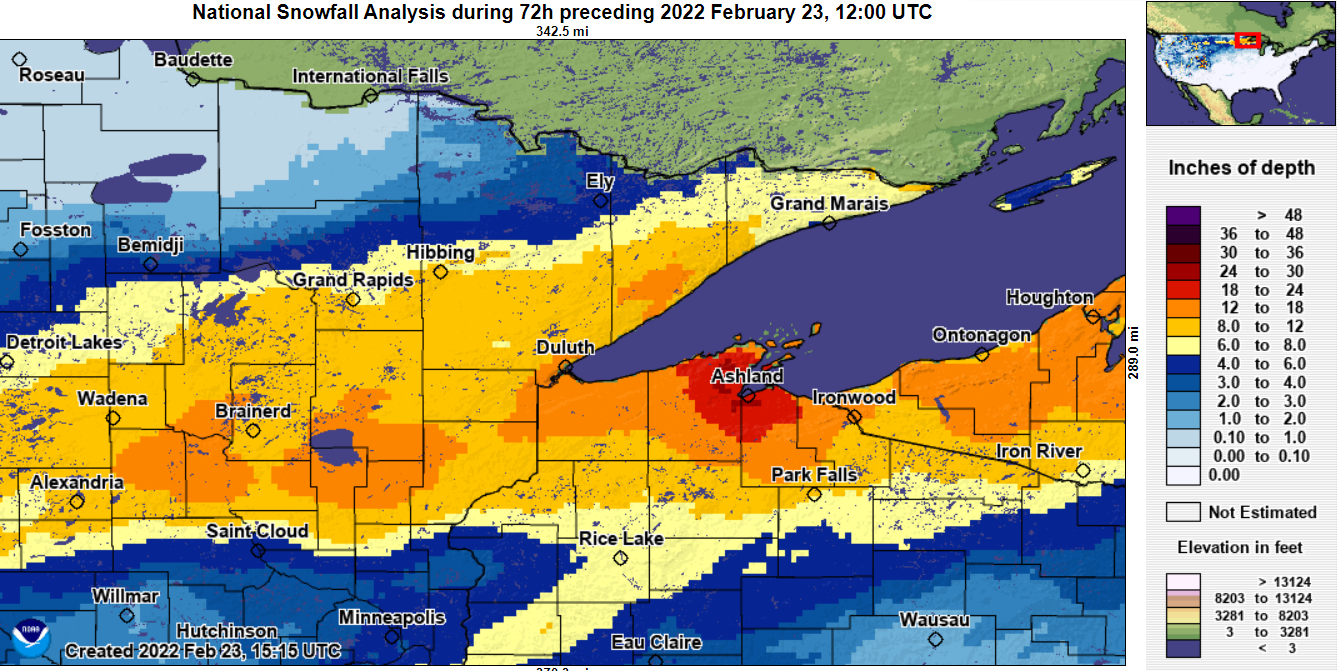 Map of storm total snowfall across northeast Minnesota and northwest Wisconsin. (View interactive map.) |
Snow/Ice
 |
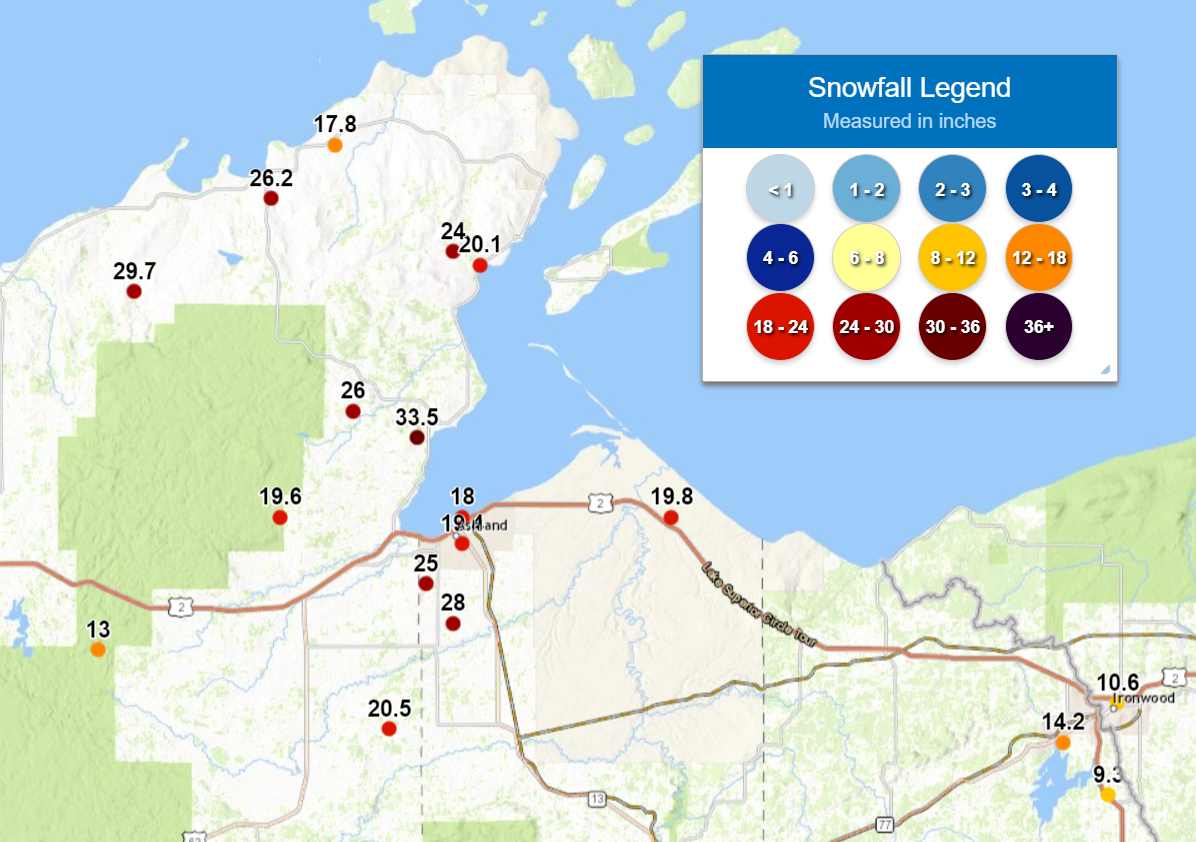 |
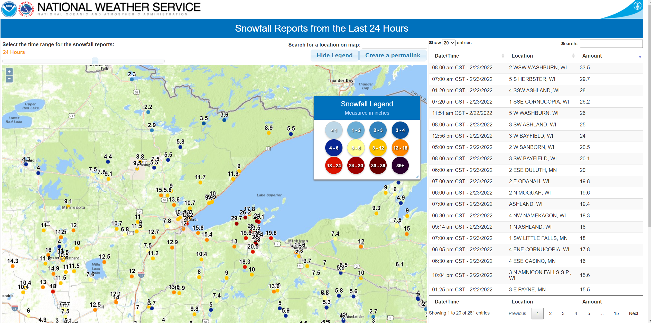
| Map of the many snowfall reports received. See full list below! | A close-up of the highest snowfall amounts in northern Bayfield and northern Ashland counties. |
PUBLIC INFORMATION STATEMENT
NATIONAL WEATHER SERVICE DULUTH MN
1013 AM CST WED FEB 23 2022

...UPDATED FINAL STORM TOTAL SNOWFALL REPORTS BY COUNTY...

LOCATION                     AMOUNT    TIME/DATE       PROVIDER

...MINNESOTA...

...AITKIN COUNTY...
12 N ISLE                    12.5 IN   0800 AM 02/23   COOP
7 N MCGREGOR                 10.7 IN   0700 AM 02/23   COCORAHS
TAMARACK 1.4 SW              6.8 IN    0700 AM 02/23   COCORAHS

...CARLTON COUNTY...
WRENSHALL                    15.7 IN   0800 AM 02/23   UCOOP
CARLTON 5.6 NE               13.7 IN   0900 AM 02/23   COCORAHS
WRENSHALL 9.7 SSE            12.9 IN   0700 AM 02/23   COCORAHS
3 E WRIGHT                   11.5 IN   0600 AM 02/23   COOP
CLOQUET 3.4 ENE              7.8 IN    0700 AM 02/23   COCORAHS

...CASS COUNTY...
PILLAGER 5.1 N               16.0 IN   0630 AM 02/23   COCORAHS
REMER 11.5 WSW               9.1 IN    0800 AM 02/23   COCORAHS
CASS LAKE                    3.9 IN    0800 AM 02/23   COOP

...COOK COUNTY...
LUTSEN 11.8 N                8.9 IN    0745 AM 02/23   COCORAHS
GRAND MARAIS 3.8 NNE         5.5 IN    0700 AM 02/23   COCORAHS
GRAND MARAIS 4.4 W           5.4 IN    0700 AM 02/23   COCORAHS

...CROW WING COUNTY...
FORT RIPLEY 0.8 N            14.9 IN   0700 AM 02/23   COCORAHS
5 W PINE CENTER              11.5 IN   0952 AM 02/23   PUBLIC
TROMMALD 6.1 NW              11.0 IN   0800 AM 02/23   COCORAHS
BRAINERD                     10.5 IN   0700 AM 02/23   COOP
CROSBY 1.1 SW                10.0 IN   0745 AM 02/23   COCORAHS

...ITASCA COUNTY...
BLACKBERRY                   10.0 IN   0959 AM 02/23   PUBLIC
COLERAINE 0.7 S              9.1 IN    0700 AM 02/23   COCORAHS
GRAND RAPIDS 6.1 N           7.8 IN    0700 AM 02/23   COCORAHS
COHASSET 7.6 NNW             7.5 IN    0700 AM 02/23   COCORAHS
BOVEY 13.4 N                 4.4 IN    0740 AM 02/23   COCORAHS

...LAKE COUNTY...
FINLAND 0.8 NNE              12.0 IN   0800 AM 02/23   COCORAHS
1 W SILVER BAY               11.9 IN   0745 AM 02/23   TRAINED SPOTTER
TWO HARBORS                  9.9 IN    0700 AM 02/23   COOP
2 SW TWO HARBORS             9.6 IN    0700 AM 02/23   TRAINED SPOTTER
WOLF RIDGE                   9.0 IN    0721 AM 02/23   COOP
TWO HARBORS 0.4 ESE          8.6 IN    0800 AM 02/23   COCORAHS
ELY 25 E                     3.6 IN    0707 AM 02/23   COOP

...PINE COUNTY...
6 SW FINLAYSON               12.0 IN   0900 AM 02/23   TRAINED SPOTTER
STURGEON LAKE 7.5 ESE        11.2 IN   0700 AM 02/23   COCORAHS

...ST. LOUIS COUNTY...
DULUTH 1.2 SE                20.0 IN   0600 AM 02/23   COCORAHS
DULUTH 17.6 NNW              13.6 IN   0600 AM 02/23   COCORAHS
BRIMSON 2 S                  11.7 IN   0700 AM 02/23   COOP
WRIGHT 9.2 NNE               11.0 IN   0700 AM 02/23   COCORAHS
DULUTH 11.8 NNE              10.7 IN   0730 AM 02/23   COCORAHS
NWS DULUTH                   10.4 IN   0600 AM 02/23   COOP
DULUTH 4.6 NE                10.0 IN   0730 AM 02/23   COCORAHS
HIBBING 11.6 SSW             9.2 IN    0700 AM 02/23   COCORAHS
COTTON 5.7 ESE               9.0 IN    0800 AM 02/23   COCORAHS
CHISHOLM 0.4 WSW             8.8 IN    0700 AM 02/23   COCORAHS
CANYON 4.6 NNE               8.8 IN    0730 AM 02/23   COCORAHS
IRON JUNCTION 3.4 NNW        7.5 IN    0530 AM 02/23   COCORAHS
EMBARRASS                    5.8 IN    0600 AM 02/23   COOP
WINTON 0.1 WSW               3.5 IN    0800 AM 02/23   COCORAHS
CELINA 2 E                   3.0 IN    0900 AM 02/23   COOP
COOK 8NE                     2.9 IN    0600 AM 02/23   COOP
KABETOGAMA 0.7 SSW           2.3 IN    0700 AM 02/23   COCORAHS
ORR 3 E                      2.2 IN    0600 AM 02/23   COOP

...WISCONSIN...

...ASHLAND COUNTY...
ASHLAND 3 S                  25.0 IN   0800 AM 02/23   COOP
ODANAH 1.6 E                 19.8 IN   0700 AM 02/23   COCORAHS
ASHLAND 0.5 WNW              19.4 IN   0700 AM 02/23   COCORAHS
1 N ASHLAND                  18.0 IN   0914 AM 02/23   PUBLIC
MELLEN                       10.0 IN   0958 AM 02/23   PUBLIC

...BAYFIELD COUNTY...
2 WSW WASHBURN               33.5 IN   0800 AM 02/23   PUBLIC
5 S HERBSTER                 29.7 IN   0700 AM 02/23   TRAINED SPOTTER
1 SSE CORNUCOPIA             26.2 IN   0720 AM 02/23   TRAINED SPOTTER
BAYFIELD 5.1 NNW             25.0 IN   0700 AM 02/23   COCORAHS
BAYFIELD FISH HATCHERY       20.1 IN   0800 AM 02/23   COOP
ASHLAND 9.8 W                19.6 IN   0600 AM 02/23   COCORAHS
BAYFIELD 1.7 SW              17.6 IN   0700 AM 02/23   COCORAHS
MASON 11.5 WNW               13.0 IN   0800 AM 02/23   COCORAHS
CLAM LAKE 4W                 10.0 IN   0700 AM 02/23   COOP
MELLEN 18.6 SW               10.0 IN   0700 AM 02/23   COCORAHS

...BURNETT COUNTY...
OAKLAND 9.0 ENE              10.9 IN   0700 AM 02/23   COCORAHS
GRANTSBURG 0.6 SSW           5.7 IN    0700 AM 02/23   COCORAHS

...DOUGLAS COUNTY...
3 N AMNICON FALLS S.P.       15.8 IN   1005 AM 02/23   TRAINED SPOTTER
POPLAR 2.0 E                 15.4 IN   0700 AM 02/23   COCORAHS
SUPERIOR 4.3 W               12.0 IN   0700 AM 02/23   COCORAHS
SOLON SPRINGS 1.2 W          10.4 IN   0700 AM 02/23   COCORAHS

...IRON COUNTY...
PENCE 0.1 E                  10.7 IN   0700 AM 02/23   COCORAHS
MERCER 7.0 NNE               9.7 IN    0700 AM 02/23   COCORAHS
HURLEY 4.1 SSE               9.3 IN    0723 AM 02/23   COCORAHS

...PRICE COUNTY...
BUTTERNUT 5.9 SW             13.6 IN   0630 AM 02/23   COCORAHS
3 SW BUTTERNUT               10.0 IN   0600 AM 02/23   CO-OP OBSERVER
PARK FALLS                   7.1 IN    0800 AM 02/23   COOP
PHILLIPS 1.3 S               5.9 IN    0600 AM 02/23   COCORAHS
BRANTWOOD 2.5 S              4.5 IN    0700 AM 02/23   COCORAHS

...SAWYER COUNTY...
HAYWARD 3.8 E                11.0 IN   0800 AM 02/23   COCORAHS
HAYWARD 9.2 NNE              9.0 IN    0600 AM 02/23   COCORAHS

...WASHBURN COUNTY...
SHELL LAKE 4.3 SW            9.8 IN    0835 AM 02/23   COCORAHS
STONE LAKE 2.0 NW            7.4 IN    0700 AM 02/23   COCORAHS
SARONA 6.8 ENE               5.0 IN    0800 AM 02/23   COCORAHS

OBSERVATIONS ARE COLLECTED FROM A VARIETY OF SOURCES WITH VARYING
EQUIPMENT AND EXPOSURES. WE THANK ALL VOLUNTEER WEATHER OBSERVERS
FOR THEIR DEDICATION. NOT ALL DATA LISTED ARE CONSIDERED OFFICIAL.

$$
Media
Coming Soon!
| Caption (source) |
Caption (source) |
Caption (source) |
Caption (source) |
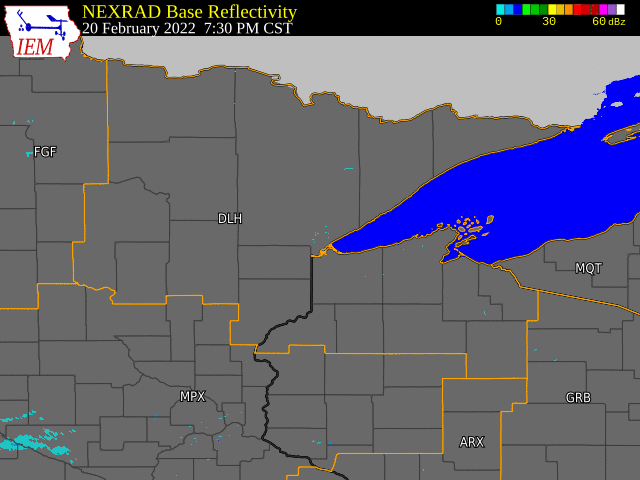
Radar
Radar Loops
 |
|
| Long duration radar loop from this winter storm. (Imagery courtesy Iowa State University/Iowa Environmental Mesonet) | Coming Soon! |
Environment
Upper Level Maps - Jet Stream/300mb Level.
 |
 |
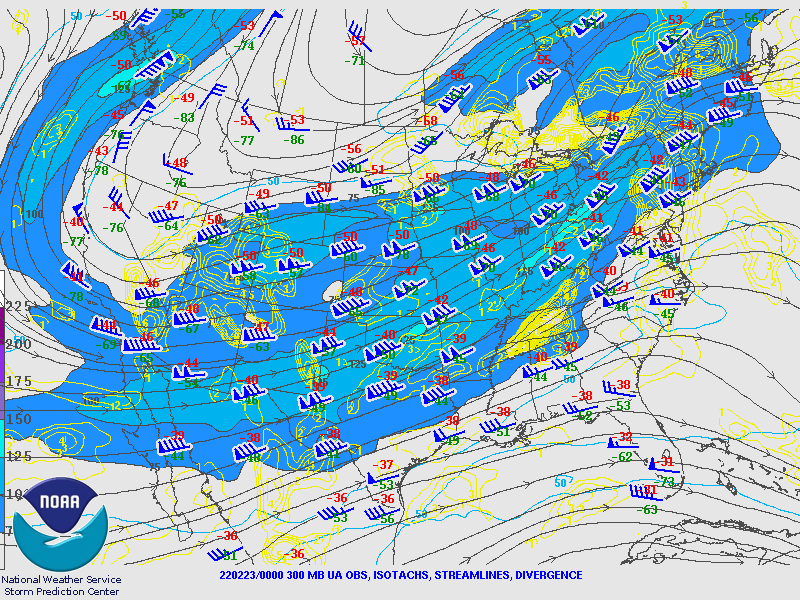 |
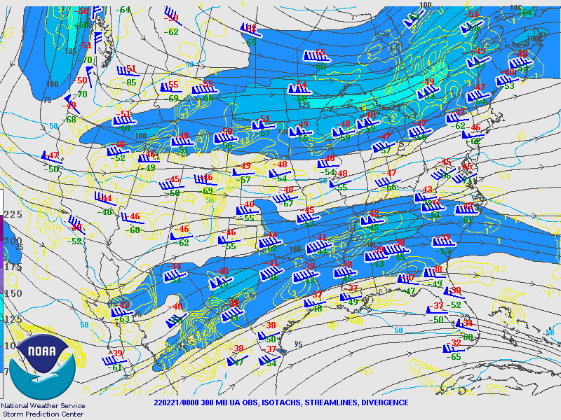
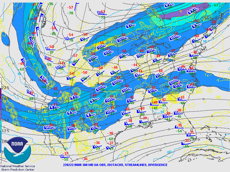
| Figure 1: 300 mb SPC analysis Mon Feb 21 at 00z (Sun Feb 20 at 6 PM CST) | Figure 2: 300 mb SPC analysis Tues Feb 22 at 00z (Mon Feb 21 at 6 PM CST) | Figure 3: 300 mb SPC analysis Wed Feb 23 at 00z (Tues Feb 22 at 6 PM CST) |
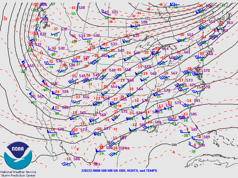
Mid Level Maps - 500 mb.
 |
 |
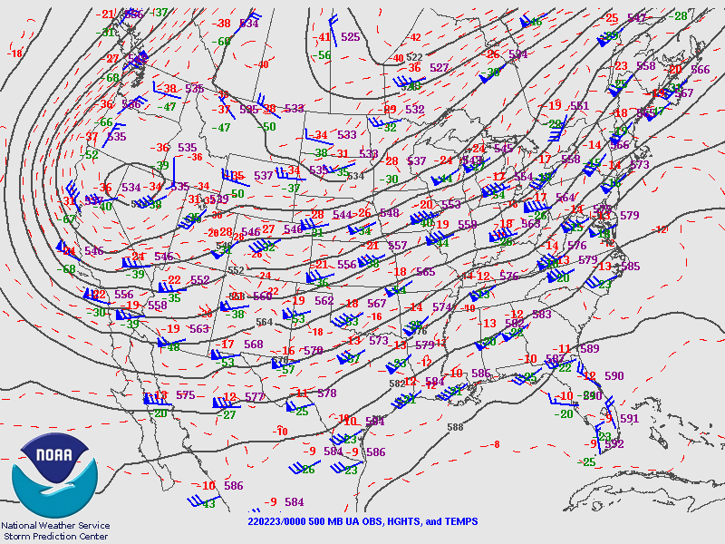 |
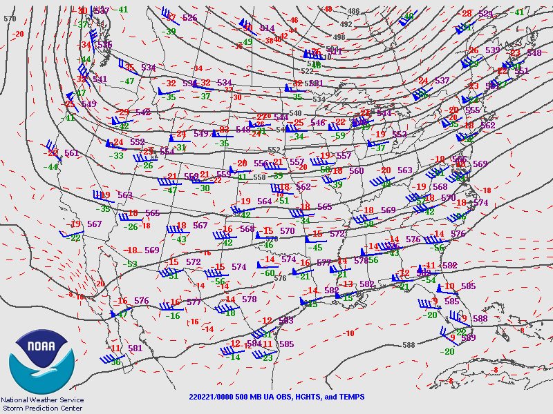
| Figure 4: 500 mb SPC analysis Mon Feb 21 at 00z (Sun Feb 20 at 6 PM CST) | Figure 5: 500 mb SPC analysis Tues Feb 22 at 00z (Mon Feb 21 at 6 PM CST) | Figure 6: 500 mb SPC analysis Wed Feb 23 at 00z (Tues Feb 22 at 6 PM CST) |
Surface Analysis Maps.
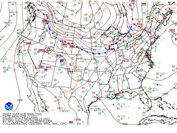 |
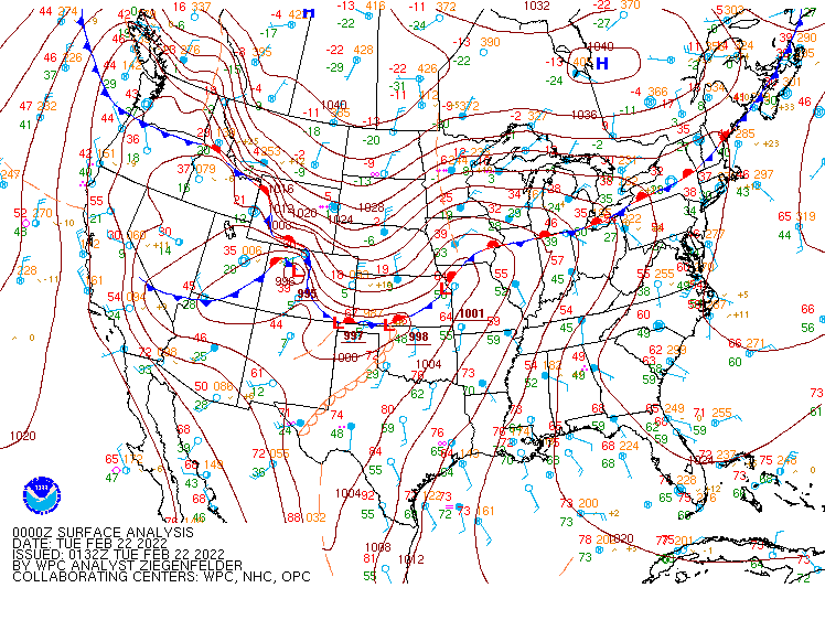 |
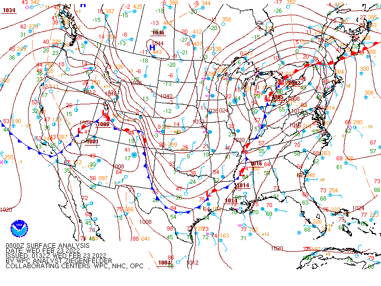 |
| Figure 7: WPC Surface analysis Mon Feb 21 at 00z (Sun Feb 20 at 6 PM CST) | Figure 8: WPC Surface analysis Tues Feb 22 at 00z (Mon Feb 21 at 6 PM CST) | Figure 9: WPC Surface analysis Wed Feb 23 at 00z (Tues Feb 22 at 6 PM CST) |
 |
Media use of NWS Web News Stories is encouraged! Please acknowledge the NWS as the source of any news information accessed from this site. |
|

