It's time to take a look back at the top weather, water, and climate stories across the Northland from 2023, as decided on by the meteorologists at NWS Duluth.
There was a relative lack of severe weather in 2023 compared to most other seasons in the recent past. Only 91 Severe Thunderstorm and Tornado Warnings were issued for the entire season, which was similar to 2021, another very quiet season.
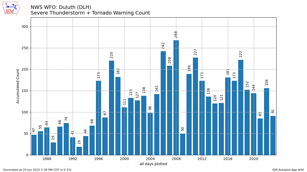
Graph courtesy of Iowa State University Automated Data Plotter: https://mesonet.agron.iastate.edu/plotting/auto/?q=44
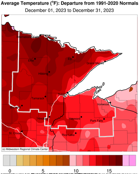
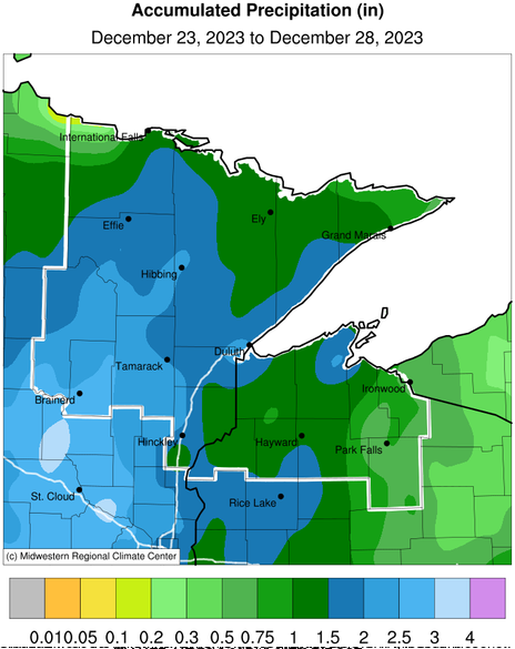
Temperatures were well above normal across the Northland for almost all of December. Several daily high temperature records were set through the month. In fact, International Falls, Brainerd, and Hibbing all recorded their warmest Decembers on record, with Duluth and Ashland not far behind with the 2nd warmest Decembers on record!
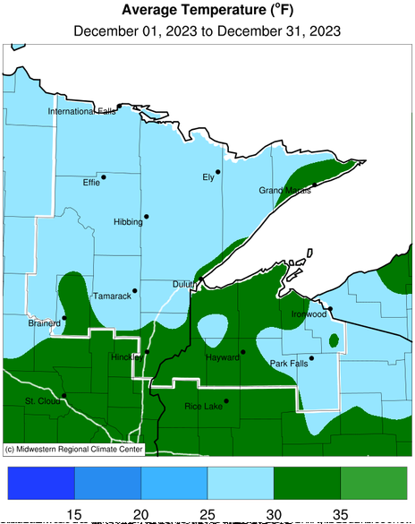
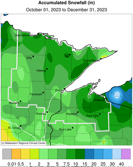
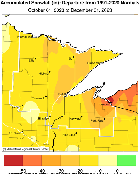
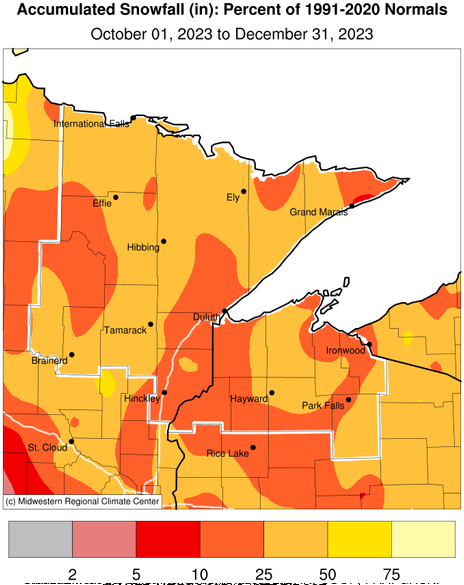
Images courtesy of Midwest Regional Climate Center
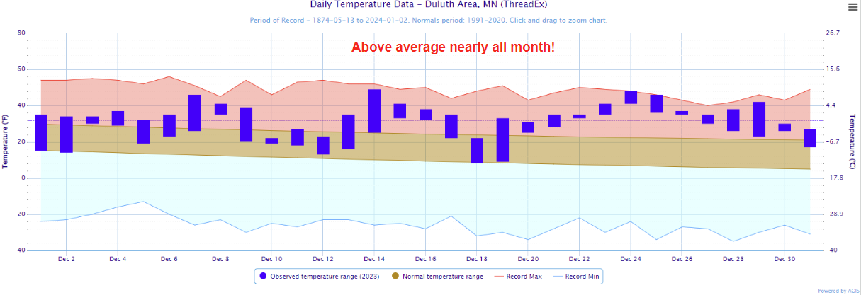
Image courtesy of NOAA Regional Climate Centers
An El Niño developed in the fall and this brought very mild weather to the Northland. As a result, very little snow fell compared to normal nearly everywhere. A rare "Brown Christmas" was experienced nearly everywhere around the Northland. In fact, it was warm enough that you could mow your lawn on Christmas! Departures were most noticeable along Wisconsin's South Shore, where the warm weather meant very little lake-effect snow.
Images courtesy of Midwest Regional Climate Center
There were two notable flooding events that impacted similar areas around Duluth and the North Shore in September 2023.
First, a flash flood event occurred in the Duluth area during the late evening of September 11th into the early morning hours of the 12th. An area of thunderstorms developed over Duluth during the evening and persisted for several hours. Rainfall totals of 3 to 6 inches fell over a small area at the top of the Duluth hillside in the Chester Creek basin in the area around College of St. Scholastica. This sent a surge of water downstream on Chester Creek down the Duluth hillside just to the east of downtown. The creek is generally underground for most of its run down the hill to Lake Superior, but the volume of water overwhelmed the tunnels and led to fast-flowing water on the surface. This resulted in a a few rescues by the fire department as the water cut-off access to an apartment building. At the bottom of the hill, Interstate 35 runs through a series of tunnels and the runoff from Chester Creek collected in the tunnels leading to a closure of the highway for a few hours until the water subsided.
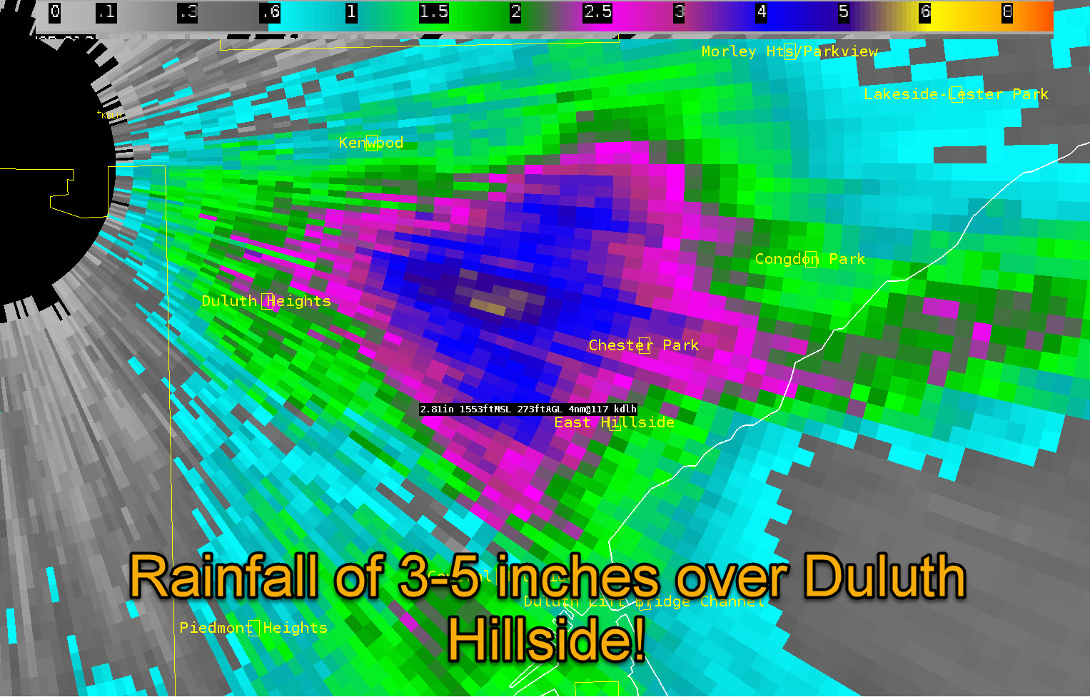
Radar estimated rainfall during the evening of September 11, 2023. Courtesy of NWS Duluth
Wow! A very localized heavy rainfall event is going on right now! A Flash Flood WARNING is in effect for Duluth- Be prepared to move to higher ground! At the airport, we've had 1.09" in the last 3 hours (since 7 PM) pic.twitter.com/xWEc6dHiWR
— NWS Duluth (@NWSduluth) September 12, 2023
A second flooding event happened along the North Shore later in the month. A concentrated area of moderate to heavy rainfall developed and impacted areas between Duluth and Two Harbors starting late on the 23rd and continuing into the 24th. Additional moisture was contributed by Lake Superior along with extra lift from the terrain along the North Shore leading to rainfall totals of 4 to 7 inches from the Duluth area to around Silver Bay. Areas of flooding and flash flooding were reported through this corridor mainly affecting the Miller Creek, Tischer Creek, Schmidt Creek, French River, Knife River and Big Sucker River watersheds. Scoured and washed out roads and railroads tracks were the primary impacts from the flooding along with build up of debris along bridges from the high water.
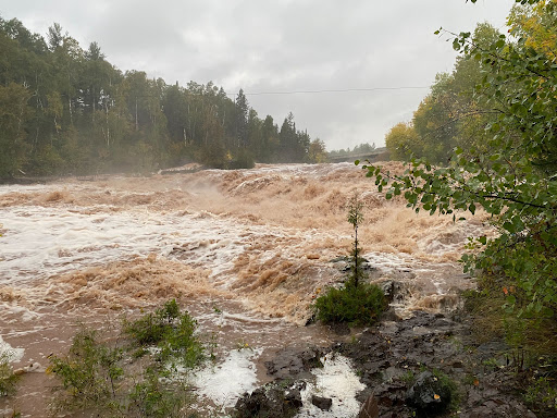
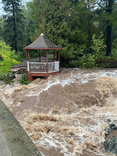
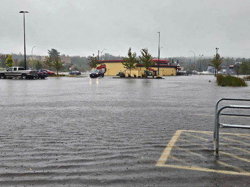
Photos of high water and flooding at Knife River Park (left), Amity Creek (middle), and the Miller Hill Mall area (right). Courtesy of NWS Duluth
A Flood Warning is in effect until 7 PM this evening from Duluth to Two Harbors. There have been many reports of washed out culverts, water over roadways, and high river/stream flows. Rain will continue this afternoon, but will decrease in intensity. #mnwx #wiwx pic.twitter.com/PCm3s9gLQA
— NWS Duluth (@NWSduluth) September 24, 2023
Warm and humid conditions developed across northeastern Minnesota on the 27th ahead of a frontal boundary that stalled out across the region. Storms developed during the afternoon hours and were prolific hail producers and they moved through. Multiple reports of hail to the size of tennis balls were received. A few areas of wind damage were reported as well, primarily in the Duluth area.
Here's a look at the storm reports from yesterday's storms. As forecasted, storms began as discrete hail producers, and then transitioned to a damaging wind threat. Heavy rain and training storms led to flooding. We are still collecting reports, so send yours our way! #mnwx #wiwx pic.twitter.com/3pnpC2oL4W
— NWS Duluth (@NWSduluth) July 28, 2023
Thanks for the photos! We did NOT receive any confirmed tornado or damage reports at this time. https://t.co/fLLQ684AKK
— NWS Duluth (@NWSduluth) July 27, 2023
A "warm storm" moved through the upper Midwest through the Christmas holiday. This storm brought very unseasonable and record-breaking warmth to the Northland as well as a prolonged period of rain that added up to around 1 to 3 inches over several days. The temperatures were so warm that both a record high temperature of 46 and a record warm low temperature of 36 were set at Duluth. In addition, 0.39" of rain fell without any sort of frozen precipitation. This is the first time in Duluth's history that rain (and only rain) has fallen at Duluth on Christmas Day. It has rained on other Christmas Days in the past, but when it did, there was always some frozen precipitation that fell at some point during the day as well. Christmas Day was warm enough that you could mow the lawn!
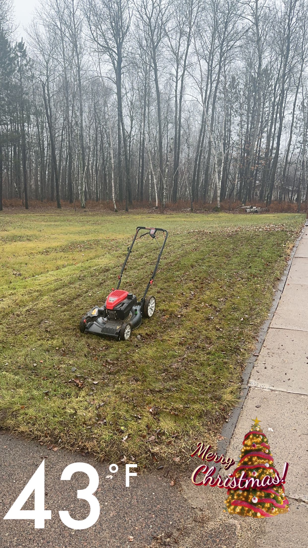
Right image is a photo illustrating the warm temperatures with no snow on Christmas Day in the Twin Ports area. Left image courtesy of the Midwestern Regional Climate Center. Right image courtesy of NWS Duluth.
Many records have been set with over the past couple of days and Duluth and Ashland have already set record highs for today, Monday December 25th! #mnwx #wiwx pic.twitter.com/4QURodJRR2
— NWS Duluth (@NWSduluth) December 25, 2023
It was a very dry summer across the Northland! Heavy snow with above normal precipitation abruptly ended around the beginning of May, with a flash drought developing at the end of spring that persisted throughout summer. Rainfall was in very short supply, with deficits around 4 to 6 inches below normal by August, and the first ever occurrence of Exceptional Drought (D4) reported across far northeast Douglas and northern Bayfield counties along the Bayfield Peninsula.
While some recent rainfall has been seen across the region, many areas are still running 4 to 6 plus inches of rainfall below normal since mid May. If you are observing drought impacts, submit a report at https://t.co/ws0X0SzxIH pic.twitter.com/8WYnw6sJNW
— NWS Duluth (@NWSduluth) August 10, 2023
A record number of air quality alerts were issued in 2023 across the state of Minnesota, including areas around the Northland. For the most part, this was due to an excessively high number of Canadian wildfires. The Minnesota Pollution Control Agency reported that, by the middle of September, they had issued 14 red alerts (unhealthy air quality for all groups) across the state. Perhaps more impressive is that these 14 red alert events covered 52 calendar days, according to Matt Taraldsen (MNPCA). Of these, there were 21 days where a red alert covered some portion of the Northland This was impressive especially considering that the source of this wildfire smoke across the state did not have a local source, unlike 2021 which also had a relatively high amount of air quality alerts, but with some local wildfire sources including the Greenwood Fire in the Arrowhead of Minnesota.
Read more about the record number of air quality alerts issued in this article from the Minnesota Pollution Control Agency.
7:45 PM Tuesday Smoke - Canadian wildfire smoke has created visibilities down to 2 miles in far north-central Minnesota so far this evening. The concentration of smoke is expected to further increase overnight. MnPCA has an Air Quality Alert for this reduced air quality. #Mnwx pic.twitter.com/iUbI1hkCWO
— NWS Duluth (@NWSduluth) June 14, 2023
Here's a shot taken by Caleb Wistad of a smoke-covered sun over our radar this AM . Air quality is currently UNHEALTHY in the Twin Ports and over NE MN and portions of NW WI. Limit your time outside, especially strenuous activity. More info at https://t.co/kTGrvp0rbH #mnwx #wiwx pic.twitter.com/yE6nlgAZ7k
— NWS Duluth (@NWSduluth) June 14, 2023
Unseasonably high snow pack with snow-to-liquid equivalents ranging from around 3 to 9 inches at the beginning of April. When this combined with a very quick early April warmup, widespread areal and river flooding was the result. While the flooding was not major in most instances, it was noteworthy in that it was fairly widespread around the region and it happened during a relative dry spell at the beginning of the month. Rain and mixed precipitation events that happened in the middle and later parts of April led to additional minor to moderate flooding and an overall very slow decline in river flood stages across the region.
Join us for our final spring flood outlook update at 3PM tomorrow. With warm temperatures on the horizon, we are expecting spring flooding to begin by next week. A recording will be available on our Facebook page afterwards. https://t.co/JSOKEdtcio#mnwx #wiwx pic.twitter.com/mBZTW6FCNm
— NWS Duluth (@NWSduluth) April 6, 2023
A Flood Warning remains in effect for the Nemadji River across Douglas County. Shown is the gage on County C near #Superior Stay away from flooded areas. An additional 1 feet rise is possible. pic.twitter.com/UXNwQAk6Zh
— NWS Duluth (@NWSduluth) April 13, 2023
The winter of 2022-2023 was a seemingly endless winter across the Northland, with many locations reporting their highest snowfalls on record (including Duluth with 140.1 inches) or falling within the top ten. Not only did the winter feature record-breaking snows, but the winter was very slow to end with snowy months through March, a brief warmup and snow melt in early April, then additional wintry weather in the middle and later part of April to cap it all off. In fact, the snow that tipped the scale for the snowiest winter on record at the NWS office in Duluth (located next to the Duluth International Airport) was measured at 2:30 AM on April 20th, and the final measurable snowfall (0.2") that brought the total over 140" fell on April 30th.
Read more about the record-breaking winter of 2022-2023 by viewing this StoryMap put together by meteorologists from NWS Duluth!
2:30 AM Update: An additional 0.4" of snow has fallen, bringing the storm total to 0.7" and the seasonal total to 135.8". This officially sets 2022-2023 as the snowiest winter season on record at Duluth, MN, breaking the old record of 135.4" set in 1995-1996. #mnwx pic.twitter.com/MrjdkojpvA
— NWS Duluth (@NWSduluth) April 20, 2023
In case you missed it, 2022-2023 has been awarded the Golden Shovel Award for Seasonal Snowfall. As of 7AM this morning, April 20, we are at 137.1". This is (so far) 1.7" over the previous record. We have until June 30 until the count resets. #mnwx #wiwx #snowfall pic.twitter.com/NRqq4ujVUN
— NWS Duluth (@NWSduluth) April 20, 2023
 |
Media use of NWS Web News Stories is encouraged! Please acknowledge the NWS as the source of any news information accessed from this site. |
|

