
A storm system will bring a number impacts to the central and eastern US. Heavy rain and thunderstorms are expected in the Gulf Coast and Deep South. Further north, a wintry mix may produce a glaze of ice from the Ozarks/Mid-South east through the Ohio Valley. Accumulating snow is expected from the central Plains east into the Upper Ohio Valley/Lower Great Lakes. Read More >
Overview
|
A strong winter storm moved into the area Sunday morning, March 24th in north-central Minnesota and spread snow northeastward. The heaviest snowfall fell Sunday night into mid-day Monday. Localized blizzard conditions were observed over the North Shore Sunday evening through Monday afternoon. Warm air aloft will brought a wintry mix of rain, freezing rain, and snow Monday and Monday night. The mixed precipitation mainly affected northwest Wisconsin and the I-35 corridor. The snowfall wrapped up Tuesday afternoon and evening March 26th, with seasonably cool and breezy north winds into Wednesday March 27th. |
 Caption |
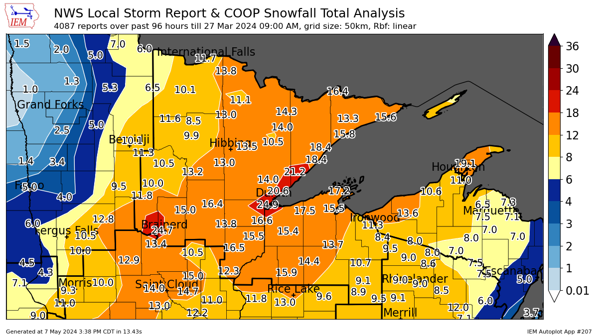
Snow/Ice
Public Information Statement
National Weather Service Duluth MN
1112 AM CDT Wed Mar 27 2024

...STORM TOTAL SNOWFALL REPORTS 4 DAY TOTALS...

Location                     Amount    Time/Date       Provider

...Minnesota...

...Aitkin County...
7 N McGregor                 16.4 in   0700 AM 03/27   COCORAHS
3 ESE Libby                  13.3 in   0700 AM 03/27   COCORAHS
McGrath 5.6 SE               13.0 in   0700 AM 03/27   COCORAHS
Tamarack 1.4 SW              12.5 in   0700 AM 03/27   COCORAHS
McGrath 4.3 SE               11.0 in   0700 AM 03/27   COCORAHS
4 NE Palisade                10.3 in   0745 AM 03/27   Trained Spotter
3 ESE Libby                  9.8 in    0700 AM 03/27   COCORAHS
Isle 5.6 NNE                 9.1 in    0700 AM 03/27   COCORAHS

...Carlton County...
Cloquet 2.1 ESE              17.5 in   0700 AM 03/27   COCORAHS
Wrenshall 9.7 SSE            16.6 in   0700 AM 03/27   COCORAHS
3 E Wright                   16.3 in   0600 AM 03/27   COOP
3 NNW Mahtowa                15.4 in   1117 PM 03/26   Trained Spotter
1 N Cloquet                  15.0 in   0830 AM 03/27   NWS Employee
3.3 W Cloquet                14.0 in   0830 AM 03/27   COOP
Cloquet 3.4 ENE              11.5 in   0700 AM 03/27   COCORAHS
Moose Lake 0.6 SW            11.0 in   0700 AM 03/27   COCORAHS
Moose Lake 3.6 ESE           10.3 in   0700 AM 03/27   COCORAHS
Esko 3.1 NW                  8.5 in    0800 AM 03/27   COCORAHS

...Cass County...
Pillager 5.1 N               22.8 in   0700 AM 03/27   COCORAHS
7 WSW Pine River             17.8 in   1216 AM 03/27   Trained Spotter
Backus 5.9 W                 11.8 in   0700 AM 03/27   COCORAHS
Cass Lake                    11.3 in   0800 AM 03/27   COOP
Deer River 6.5 S             11.0 in   0800 AM 03/27   COCORAHS
Federal Dam 0.3 S            10.5 in   0700 AM 03/27   COCORAHS
Hackensack 5.4 NE            10.0 in   0800 AM 03/27   COCORAHS
Cass Lake                    10.0 in   0800 AM 03/27   COOP
3 ESE Bena                   10.0 in   0800 AM 03/27   COCORAHS

...Cook County...
3.7 NE Sea Gull Lake         16.4 in   0700 AM 03/27   COOP
Tofte 4.9 NE                 15.8 in   0700 AM 03/27   COCORAHS
Hovland 0.1 NE               15.6 in   0700 AM 03/27   COCORAHS
Hovland 2.8 WNW              14.8 in   0700 AM 03/27   COCORAHS
Grand Marais 3.8 NNE         14.0 in   0700 AM 03/27   COCORAHS
Grand Marais 11.6 ENE        13.7 in   0700 AM 03/27   COCORAHS
Lutsen 11.8 N                13.3 in   0800 AM 03/27   COCORAHS
Grand Marais 4.4 W           13.2 in   0700 AM 03/27   COCORAHS
Grand Marais 4.4 WSW         10.2 in   0700 AM 03/27   COCORAHS

...Crow Wing County...
Baxter 1.6 NE                24.7 in   0750 AM 03/27   COCORAHS
Brainerd                     20.5 in   0700 AM 03/27   COOP
Brainerd 6.5 S               15.4 in   0900 AM 03/27   COCORAHS
Brainerd 6.0 N               15.3 in   0730 AM 03/27   COCORAHS
Aitkin 8.4 NW                15.0 in   0500 AM 03/27   COCORAHS
Crosby 1.1 SW                13.7 in   0745 AM 03/27   COCORAHS
Fort Ripley 0.8 N            13.4 in   0700 AM 03/27   COCORAHS
Pequot Lakes 3.2 N           13.2 in   0700 AM 03/27   COCORAHS
Nisswa 4.2 ENE               13.0 in   0800 AM 03/27   COCORAHS
Emily 6.1 SSE                11.0 in   0830 AM 03/27   COCORAHS
Brainerd 8.3 ESE             10.5 in   0800 AM 03/27   COCORAHS
Brainerd 7.7 SSE             9.5 in    0700 AM 03/27   COCORAHS

...Itasca County...
Cohasset 7.4 S               13.2 in   0800 AM 03/27   COCORAHS
Northome 8.4 ESE             11.6 in   0730 AM 03/27   COCORAHS
Grand Rapids 6.1 N           10.1 in   0700 AM 03/27   COCORAHS
Warba 2.2 NNW                10.1 in   0715 AM 03/27   COCORAHS
Grand Rapids 6.2 SSW         9.2 in    0600 AM 03/27   COCORAHS
Coleraine 0.7 S              9.1 in    0700 AM 03/27   COCORAHS
Keewatin 0.2 SSE             9.1 in    0800 AM 03/27   COCORAHS
Bovey 13.4 N                 8.7 in    0650 AM 03/27   COCORAHS
Cohasset 7.6 NNW             8.6 in    0700 AM 03/27   COCORAHS
Bovey 3.5 S                  7.9 in    0800 AM 03/27   COCORAHS

...Koochiching County...
International Falls 0.6 NW   11.7 in   0700 AM 03/27   COCORAHS
International Falls          11.6 in   0600 AM 03/27   Official NWS Obs
International Falls 8.8 E    10.5 in   0700 AM 03/27   COCORAHS
International Falls 5.1 SSW  10.4 in   0700 AM 03/27   COCORAHS
International Falls 1.1 NNW  10.3 in   0800 AM 03/27   COCORAHS
International Falls 10.3 WSW 6.9 in    0700 AM 03/27   COCORAHS

...Lake County...
Two Harbors 3.6 WNW          20.4 in   0700 AM 03/27   COCORAHS
Silver Bay                   18.4 in   0700 AM 03/27   UCOOP
Two Harbors 2.1 NW           17.5 in   0700 AM 03/27   COCORAHS
Silver Bay 0.4 W             16.5 in   0800 AM 03/27   COCORAHS
Two Harbors                  13.5 in   0700 AM 03/27   COOP
Two Harbors 19.8 N           13.4 in   0700 AM 03/27   COCORAHS
Two Harbors 2.0 ENE          12.3 in   0700 AM 03/27   COCORAHS
Ely 25 E                     9.5 in    0600 AM 03/27   COOP

...Pine County...
Sandstone 0.1 WSW            16.5 in   0700 AM 03/27   COCORAHS
Hinckley 13.7 E              14.0 in   0700 AM 03/27   COCORAHS
Sturgeon Lake 7.5 ESE        13.7 in   0700 AM 03/27   COCORAHS
Hinckley 8.7 ENE             13.0 in   0707 AM 03/27   COCORAHS
Kerrick 3.0 NNE              12.8 in   0800 AM 03/27   COCORAHS
Pine City 0.7 SSW            12.3 in   0700 AM 03/27   COCORAHS
2 SSW Moose Lake             12.3 in   0952 AM 03/27   Trained Spotter
Sturgeon Lake 0.4 ENE        11.9 in   0710 AM 03/27   COCORAHS
Willow River                 11.5 in   0944 AM 03/27   Trained Spotter
Hinckley 13.7 E              11.0 in   0700 AM 03/27   COCORAHS

...St. Louis County...
Duluth 7.9 SW                24.9 in   0900 AM 03/27   COCORAHS
Duluth 7.4 NNE               20.6 in   0700 AM 03/27   COCORAHS
5 NNW Knife River            19.2 in   0800 AM 03/27   COCORAHS
Duluth 4.1 SW                19.0 in   0630 AM 03/27   COCORAHS
Duluth 9.6 SW                18.8 in   0730 AM 03/27   COCORAHS
NWS Duluth                   17.3 in   0700 AM 03/27   COOP
Duluth 1.2 SE                16.0 in   0600 AM 03/27   COCORAHS
Duluth 12.1 NNW              15.2 in   0700 AM 03/27   COCORAHS
Duluth 17.6 NNW              15.0 in   0600 AM 03/27   COCORAHS
Wright 9.2 NNE               15.0 in   0600 AM 03/27   COCORAHS
Duluth 6.0 NE                15.0 in   0700 AM 03/27   COCORAHS
Duluth 7.9 SW                14.6 in   0700 AM 03/27   COCORAHS
Ely 0.9 WNW                  14.3 in   0700 AM 03/27   COCORAHS
Duluth 17.6 NNW              14.0 in   0700 AM 03/27   COCORAHS
Duluth 4.6 NE                14.0 in   0730 AM 03/27   COCORAHS
Kabetogama 0.7 SSW           13.8 in   0555 AM 03/27   COCORAHS
2 NNE Duluth                 13.7 in   0700 AM 03/27   Cocorahs
Duluth 2.0 NNE               13.7 in   0700 AM 03/27   COCORAHS
Iron Junction 3.4 NNW        13.5 in   0400 AM 03/27   COCORAHS
Chisholm 0.7 NW              13.1 in   0630 AM 03/27   COCORAHS
Hibbing 11.6 SSW             13.0 in   0700 AM 03/27   COCORAHS
Celina 2 E                   13.0 in   0900 AM 03/27   COOP
Brimson 2 S                  12.9 in   0700 AM 03/27   COOP
5.1 N Floodwood              12.9 in   0730 AM 03/27   COOP
Babbitt 4.4 N                12.0 in   0700 AM 03/27   COCORAHS
Cotton 5.7 ESE               11.7 in   0800 AM 03/27   COCORAHS
Duluth 3.0 NE                11.6 in   0600 AM 03/27   COCORAHS
Ely 1.8 SSW                  11.6 in   0700 AM 03/27   COCORAHS
Biwabik 2.9 NNE              11.5 in   0800 AM 03/27   COCORAHS
2 SW Gary New Duluth         11.3 in   0700 AM 03/27   Public
Orr 3 E                      11.1 in   0700 AM 03/27   COOP
Duluth 3.0 NE                11.0 in   0600 AM 03/27   COCORAHS
Ely 5.2 WSW                  11.0 in   0700 AM 03/27   COCORAHS
Knife River 1.8 N            10.9 in   0655 AM 03/27   COCORAHS
Hoyt Lakes 3.1 SSW           10.5 in   0805 AM 03/27   COCORAHS
Ely 2.5 NW                   10.4 in   0700 AM 03/27   COCORAHS
Ely 6.4 SSW                  10.1 in   0700 AM 03/27   COCORAHS
Duluth 15.4 NNW              10.0 in   0700 AM 03/27   COCORAHS
Canyon 4.6 NNE               10.0 in   0810 AM 03/27   COCORAHS
Embarrass                    9.5 in    0600 AM 03/27   COOP
Aurora 0.6 WSW               9.2 in    0800 AM 03/27   COCORAHS
Aurora 7.4 S                 9.1 in    0651 AM 03/27   COCORAHS
Hibbing 2.1 NNE              8.5 in    0700 AM 03/27   COCORAHS
Cook 6.0 N                   8.5 in    0800 AM 03/27   COCORAHS
Cook 8NE                     6.4 in    0600 AM 03/27   COOP

...Wisconsin...

...Ashland County...
Ashland 0.5 WNW              14.6 in   0700 AM 03/27   COCORAHS
Ashland 3 S                  11.0 in   0800 AM 03/27   COOP

...Bayfield County...
Bayfield 5.1 NNW             17.2 in   0830 AM 03/27   COCORAHS
Mason 11.5 WNW               16.2 in   0800 AM 03/27   COCORAHS
Bayfield Fish Hatchery       16.1 in   0800 AM 03/27   COOP
Washburn 3.7 WSW             15.5 in   0700 AM 03/27   COCORAHS
5 SE Iron River              15.4 in   0700 AM 03/27   COCORAHS
1 SSE Cornucopia             14.4 in   0600 AM 03/27   Trained Spotter
Bayfield 1.7 SW              14.4 in   0700 AM 03/27   COCORAHS
Mellen 18.6 SW               13.7 in   0700 AM 03/27   COCORAHS
Clam Lake 4W                 13.7 in   0700 AM 03/27   COOP
Cable 10.2 ENE               12.2 in   0800 AM 03/27   COCORAHS
Washburn 0.2 NW              11.5 in   0800 AM 03/27   COCORAHS
Bayfield 1.2 N               10.4 in   0700 AM 03/27   COCORAHS

...Burnett County...
Spooner 10.6 WNW             13.3 in   0800 AM 03/27   COCORAHS
Grantsburg 0.6 SW (KWIGRANT1 12.1 in   0733 AM 03/27   COCORAHS
Oakland 9.0 ENE              12.0 in   0500 AM 03/27   COCORAHS

...Douglas County...
Solon Springs 1.2 W          15.4 in   0700 AM 03/27   COCORAHS
Superior 2.3 SSW             15.0 in   0700 AM 03/27   COCORAHS
1 NNW Lake Nebagamon         15.0 in   0800 AM 03/27   Public
Poplar 7.4 SSW               13.8 in   0700 AM 03/27   COCORAHS
Superior 4.3 W               13.3 in   0900 AM 03/27   COCORAHS
Superior 2.0 WNW             13.0 in   0800 AM 03/27   COCORAHS
Superior 2 ENE               12.0 in   1158 PM 03/26   COOP
7 W Superior                 12.0 in   1026 AM 03/27   Trained Spotter
Brule 0.1 NE                 9.4 in    0745 AM 03/27   COCORAHS
Maple 1.0 ENE                7.1 in    0700 AM 03/27   COCORAHS

...Iron County...
Gile                         11.3 in   1130 PM 03/26   Trained Spotter
Saxon 3.8 W                  10.7 in   0700 AM 03/27   COCORAHS
Hurley 4.1 SSE               10.0 in   0753 AM 03/27   COCORAHS
Mercer 0.4 N                 9.2 in    0800 AM 03/27   COCORAHS
Mercer 7.0 NNE               8.4 in    0700 AM 03/27   COCORAHS
Hurley                       8.0 in    0800 AM 03/27   COOP

...Price County...
Park Falls                   10.7 in   0800 AM 03/27   COOP
Brantwood 7.4 S              9.5 in    0400 AM 03/27   COCORAHS
Butternut 5.9 SW             9.2 in    0630 AM 03/27   COCORAHS
Brantwood 2.5 S              9.1 in    0700 AM 03/27   COCORAHS
Phillips 0.4 SSW             9.1 in    0800 AM 03/27   COCORAHS
Butternut 3 SW               8.5 in    0600 AM 03/27   COOP
Phillips 1.3 S               7.5 in    0600 AM 03/27   COCORAHS

...Sawyer County...
Hayward 4.4 SSE              14.4 in   0700 AM 03/27   COCORAHS
Hayward 9.2 NNE              13.5 in   0600 AM 03/27   COCORAHS
Hayward 1.0 SW               12.2 in   0600 AM 03/27   COCORAHS
Hayward 9.7 NE               10.6 in   0800 AM 03/27   COCORAHS

...Washburn County...
3 E Sarona                   15.9 in   0700 AM 03/27   COOP
Shell Lake 4.3 SW            14.0 in   0724 AM 03/27   COCORAHS
3 E Sarona                   12.4 in   0700 AM 03/27   COOP
Sarona 4.5 NNE               11.6 in   0700 AM 03/27   COCORAHS
Springbrook 4.0 N            9.6 in    0830 AM 03/27   COCORAHS
Sarona 3.6 NE                8.5 in    0700 AM 03/27   COCORAHS

...Maritime Stations...
Superior 3.7 WNW             13.3 in   0700 AM 03/27   COCORAHS

Observations are collected from a variety of sources with varying
equipment and exposures. We thank all volunteer weather observers
for their dedication. Not all data listed are considered official.
Photos & Video
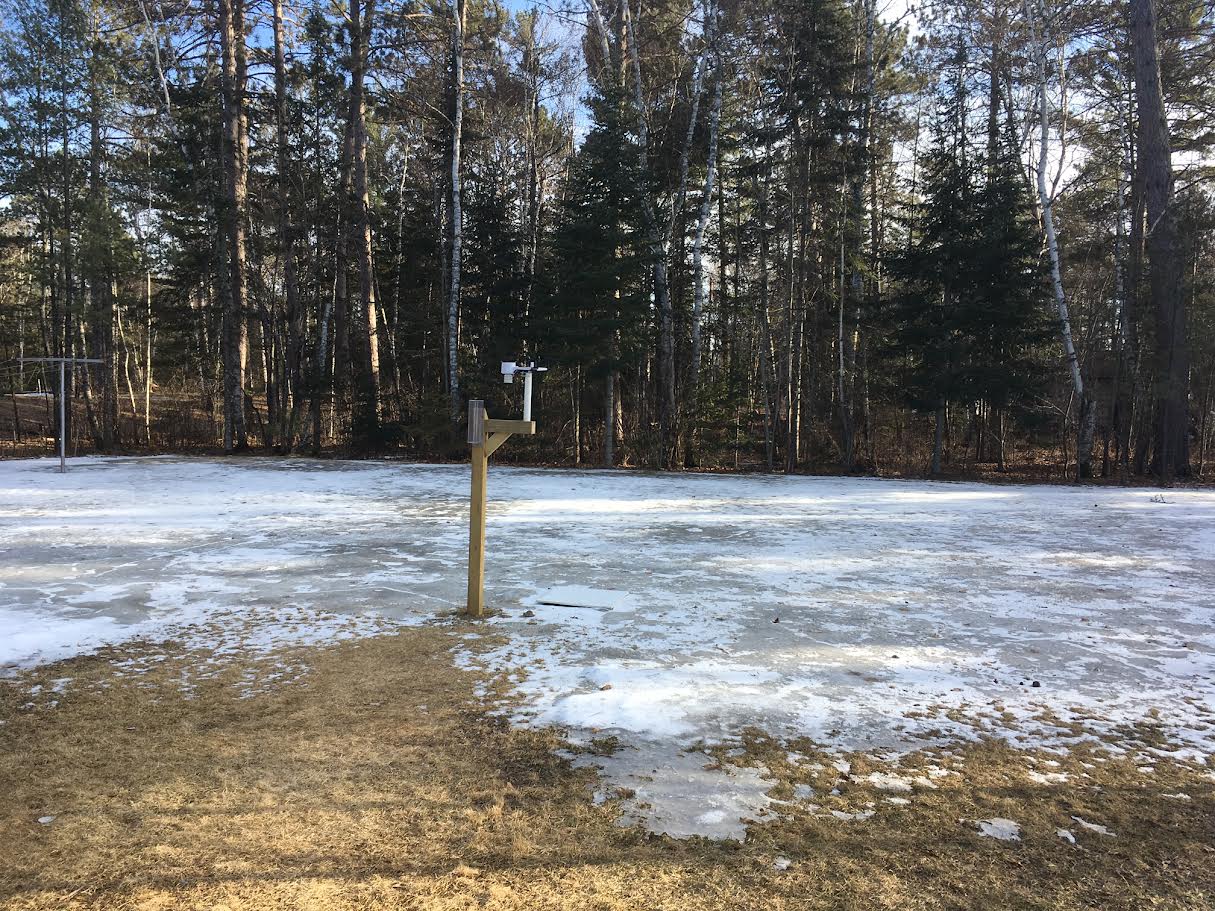
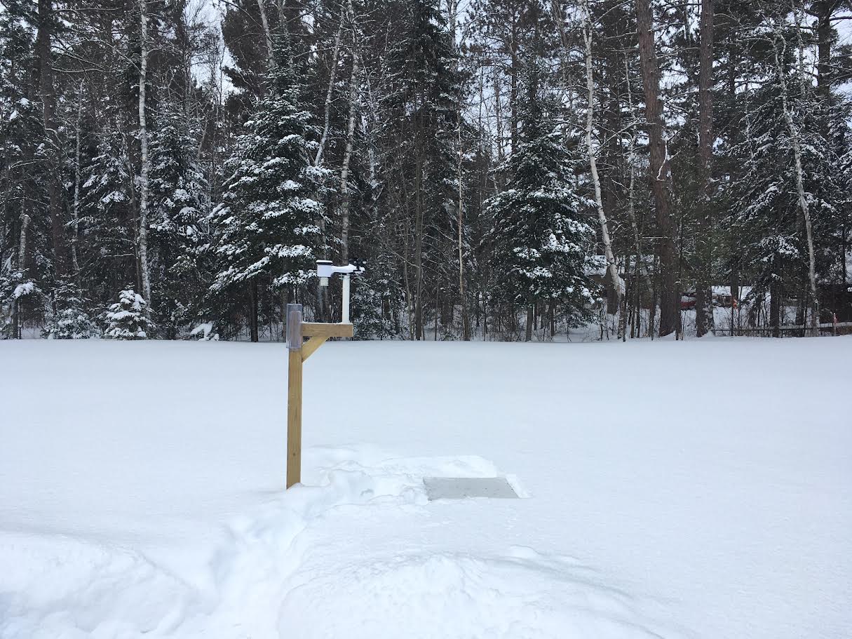
Before and After Comparisons of the Snowfall
 |
 |
 |
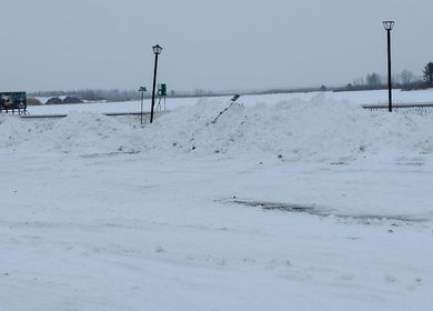 |
| A before storm image from our observer near Ely, MN (COOP Observer) |
An after storm image from our observer near Ely, MN (COOP Observer) |
A before storm image from near McGregor, MN (source) |
An after storm image from near McGregor, MN (source) |
Radar
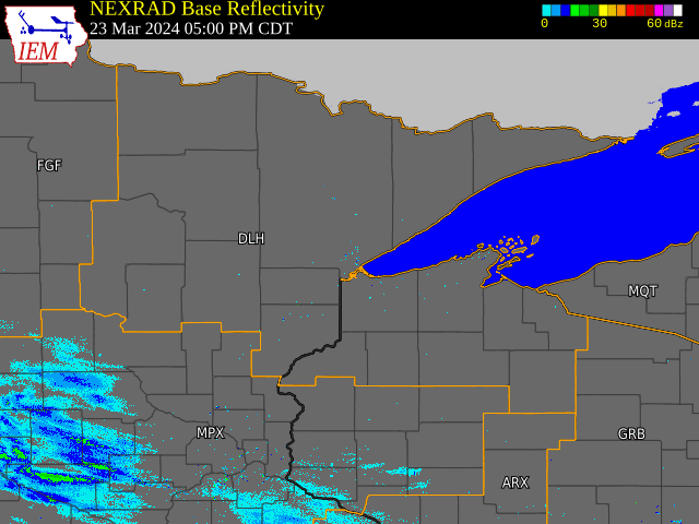
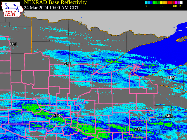
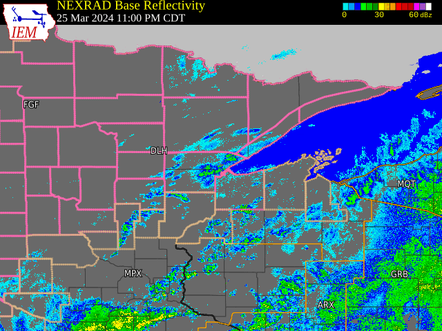
Here is the radar imagery from this snowstorm.
 |
 |
 |
|
Radar Imagery from Saturday 3/23 at 5 PM to Sunday 3/24 at 10 AM This was the first wave of light snow that fell late Saturday night into Sunday morning, producing up to 2.5 inches of snow. |
Radar Imagery from Sunday 3/24 at 10 AM to Monday 3/25 at 11 PM This was the most intense snowfall, producing the bulk of the snow. This was also when we had mixed precipitation, even purely rainfall across northwest Wisconsin. |
Radar Imagery from Monday 3/25 at 11 PM to Wednesday 3/27 at 7 AM For this portion of the event, the mixed precipitation over northwest Wisconsin became all snow during the day on Tuesday, then continued to fall overnight even as it diminished from west to east. |
Environment
Synoptic summary.
 |
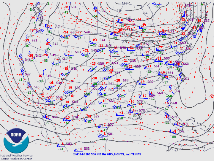 |
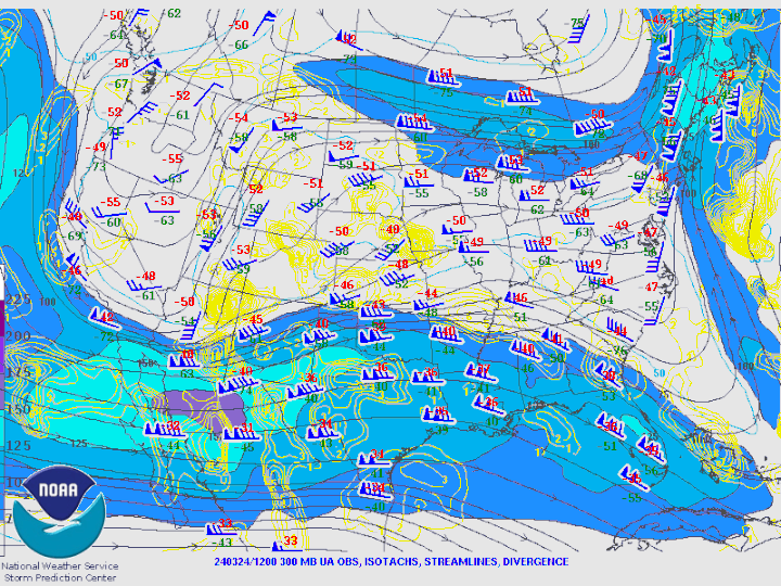
| Figure 1: A loop of the 300 MB winds and heights | Figure 2: A loop of the 500 MB winds and heights |
 |
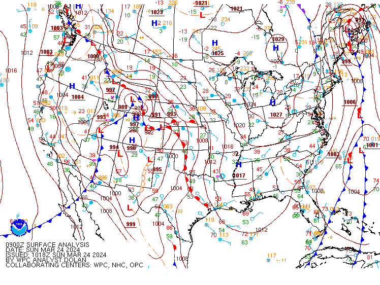 |
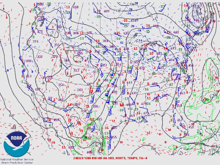
| Figure 3: A loop of the 850 MB winds and heights | Figure 4: A loop of the surface analysis |
Additional environmental data.
 |
 |
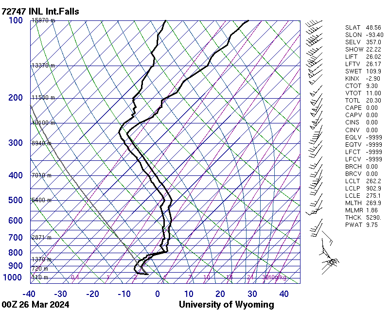 |
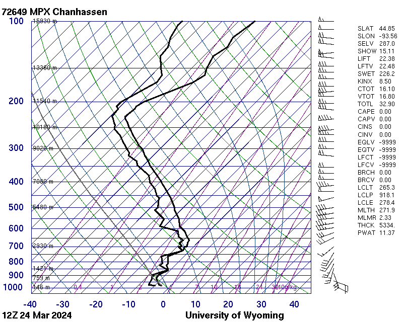
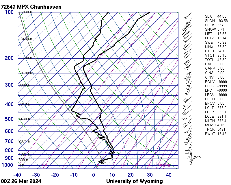
| Figure 5: March 24, 2024 6 AM (12Z) CT observed upper-air sounding from site MPX in Chanhassen, MN. Courtesy of UoWy Atmospheric Sciences. | Figure 6: March 25, 2024 6 PM (25/00Z) CT observed upper-air sounding from site MPX in Chanhassen, MN. Courtesy of UoWy Atmospheric Sciences. | Figure 7: March 25, 2024 6 PM (25/00Z) CT observed upper-air sounding from site INL in International Falls, MN. Courtesy of UoWy Atmospheric Sciences. |
 |
Media use of NWS Web News Stories is encouraged! Please acknowledge the NWS as the source of any news information accessed from this site. |
|

