Summary of Heavy Snow Event
April 10-12th, 2008
Overview
|
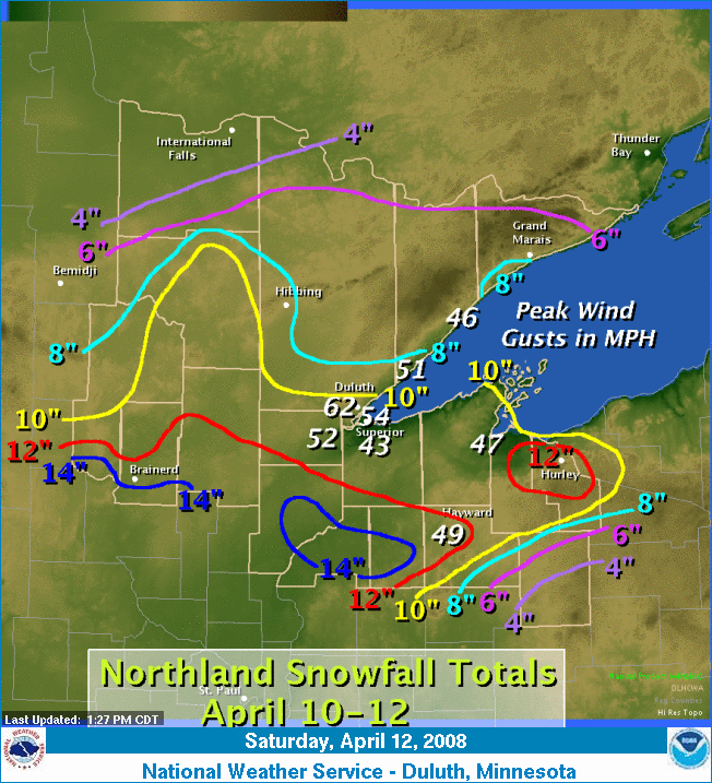
A blizzard impacted the North Shore, Twin Ports, and points east along the South Shore of Lake Superior late Thursday through Friday, April 10th-12th, 2008. Heavy snow and high winds, frequently gusting to more than 40 mph, resulted in white-out conditions and widespread blowing and drifting snow across the Northland. Lightning was also observed at many locations. Numerous trees were downed and power outages were reported as well. The graphic at right shows the snowfall totals from this storm contoured every 2 inches. Peak wind gusts in miles per hour near Lake Superior are also shown in the white, italic text. |
 |
Snow Reports
000
NOUS43 KDLH 121901
PNSDLH

PUBLIC INFORMATION STATEMENT
NATIONAL WEATHER SERVICE DULUTH MN
200 PM CDT SAT APR 12 2008

A BLIZZARD IMPACTED THE NORTH SHORE...TO DULUTH...AND POINTS EAST
ALONG THE SOUTH SHORE LATE THURSDAY THROUGH FRIDAY. HEAVY SNOW AND
HIGH WINDS...FREQUENTLY GUSTING MORE THAN 40 MPH...RESULTED IN
WHITEOUT CONDITIONS AND WIDESPREAD BLOWING AND DRIFTING SNOW.
THUNDER AND LIGHTNING WAS ALSO OBSERVED AT MANY LOCATIONS ACROSS THE
NORTHLAND. NUMEROUS TREES WERE DOWNED...AND POWER OUTAGES WERE ALSO
REPORTED.

WIND AND SNOWFALL REPORTS ARE LISTED BELOW.

THE FOLLOWING ARE SNOWFALL TOTALS FOR THE STORM...WHICH BEGAN
THURSDAY EVENING AND ENDED EARLY SATURDAY. APPRECIATION IS EXTENDED
TO SNOWFALL SPOTTERS...CO-OPERATIVE OBSERVERS...AND TRANSPORTATION
OFFICIALS FOR THESE REPORTS.

SNOW REPORTS LISTED BY AMOUNT

 INCHES  LOCATION                 ST  COUNTY
 ------  -----------------------  --  --------------
 16.90   3 NE ASKOV               MN  PINE
 15.00   GILE                     WI  IRON
 14.00   SARONA                   WI  WASHBURN
 14.00   5 N PILLAGER             MN  CASS
 13.60   BAYFIELD                 WI  BAYFIELD
 13.00   SAXON                    WI  IRON
                 4 FOOT DRIFTS
 12.50   10 W PALISADE            MN  AITKIN
 12.50   8 S HAYWARD              WI  SAWYER
 12.20   5 N MARCELL              MN  ITASCA
 12.00   GURNEY                   WI  IRON
 11.30   KERRICK                  MN  PINE
 11.00   HAYWARD                  WI  SAWYER
 10.50   14 W DRUMMOND            WI  BAYFIELD
                 BARNES TWNSHP
 10.50   SARONA                   WI  WASHBURN
 10.20   WRENSHALL                MN  CARLTON
 10.00   20 NE PARK FALLS         WI  IRON
 10.00   GLIDDEN                  WI  ASHLAND
 10.00   GILE                     WI  IRON
 10.00   CLOQUET                  MN  CARLTON
 10.00   BAYFIELD                 WI  BAYFIELD
 10.00   WRENSHALL                MN  CARLTON
  9.90   DULUTH                   MN  ST. LOUIS
  9.80   GRAND RAPIDS             MN  ITASCA
  9.50   GRAND RAPIDS             MN  SOUTHERN ITASCA
  9.20   DULUTH                   MN  ST. LOUIS
                 MARTIN ROAD...NEAR RICE LAKE TOWNSHIP.
  9.00   OULU                     WI  BAYFIELD
  9.00   4 SW GORDON              WI  DOUGLAS
  9.00   BAYFIELD                 WI  BAYFIELD
                 BAYFIELD STATE FISH HATCHERY
  8.50   MAPLE                    WI  DOUGLAS
  8.40   COHASSET                 MN  ITASCA
  8.20   SARONA                   WI  WASHBURN
  8.20   1 NE LUTSEN              MN  COOK
  8.00   GILE                     WI  IRON
  8.00   1 SW HINCKLEY            MN  PINE
  8.00   22 N AITKIN              MN  AITKIN
  7.30   SILVER BAY               MN  LAKE
  7.30   ORR                      MN  ST. LOUIS
  7.00   GILE                     WI  IRON
  6.50   DULUTH                   MN  ST. LOUIS
                 LAKEWOOD TOWNSHIP.
  6.50   CULVER                   MN  ST. LOUIS
  6.00   PARK FALLS               WI  PRICE
  5.50   BRIMSON                  MN  ST. LOUIS
  4.00   1 W PHILLIPS             WI  PRICE

$$
Wind Reports
000
NOUS43 KDLH 121913
PNSDLH

PUBLIC INFORMATION STATEMENT
NATIONAL WEATHER SERVICE DULUTH MN
200 PM CDT SAT APR 12 2008

PEAK WIND GUSTS...

DULUTH INTERNATIONAL AIRPORT...62 MPH
DULUTH SKY HARBOR AIRPORT...54 MPH
CLOQUET...52 MPH
TWO HARBORS...51 MPH
HAYWARD...49 MPH
ASHLAND...47 MPH
SILVER BAY...46 MPH
SUPERIOR...43 MPH

$$
 |
Media use of NWS Web News Stories is encouraged! Please acknowledge the NWS as the source of any news information accessed from this site. |
|

