
Flash flooding threatens areas from the Tennessee Valley to the Carolinas as storms repeat along a stalled front. Monsoonal storms may trigger flooding in the Southwest. Dangerous heat expands across the Desert Southwest, Plains, mid-Mississippi Valley and Southern Tier. Critical fire weather for interior Pacific Northwest. Cooler, drier air brings brief relief to the Great Lakes and Northeast. Read More >
Overview
|
In late January 2019, a historic arctic outbreak brought bitterly cold wind chills and record-breaking cold temperatures to the Midwest. Many schools and some businesses and government offices were closed for three days, with USPS mail delivery even suspended on Wednesday, January 30th due to extremely dangerous wind chills. The coldest temperatures occurred on the morning on January 31st when Cotton, MN recorded a low of -56, approaching the Minnesota state record low of -60 set back in 1996. The low of -56 at Cotton, MN was the coldest temperature recorded in the Lower 48 for this entire period of cold weather!
Related Web Pages:
|
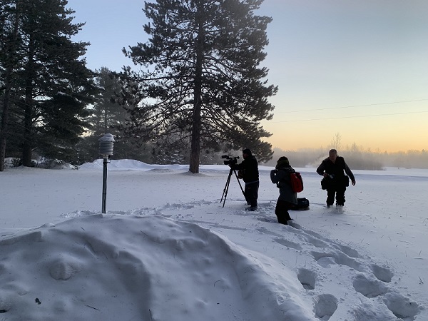 Local and national media outlets check out the official NWS Cooperative Observer temperature sensor in Cotton, MN. (Photo: NWS) |
Event Summary
The national low temperature this morning was -56 at Cotton, Minnesota. Frigid temps were reported around the Upper Midwest, with a few locations setting all-time records. Reports from far NW Illinois will be reviewed to see if the Illinois all time record low of -36 was broken. pic.twitter.com/VRZHuB3FUq
— NWS WPC (@NWSWPC) January 31, 2019
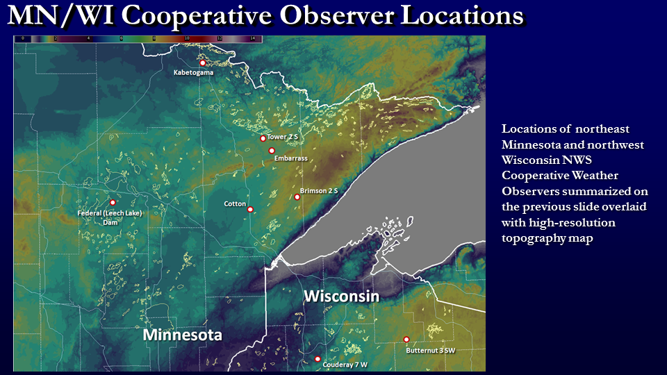
In the days before this arctic outbreak, meteorologists at the National Weather Service predicted that conditions could be favorable for record-setting cold, possibly approaching the Minnesota state record low of -60 set in Tower, MN in 1996. The Minnesota State Climatology office only considers observations from well-maintained weather stations official for the purpose of state records, which in the case of temperatures meant that only National Weather Service-installed and maintained equipment - automated "ASOS" weather stations found at some airports and volunteer National Weather Service cooperative ("co-op") observers. Temperature observations from other platforms (many of which did not even exist in 1996), will not be considered because of potential data-quality control concerns, and the need to maintain continuity with the historical climatological database. Some of the observing platforms that will not be considered include AWOS, RWIS, RAWS, and commercially purchased "backyard" weather stations.
Because volunteer cooperative observer sites mostly consistent of private citizens who volunteer to report, these observation locations have changed slightly over time. In particular, the locations at two of our historically cold locations, Embarrass and Tower, MN, have changed since the late-January/early February extreme cold event in 1996. The co-op observers at that time have both since retired after many years of dedicated service. Therefore, the NWS recruited new co-op observers at both of these sites, but the current location of the observation sites in both Tower and Embarrass are slightly different than in 1996. The current observer at Cotton, MN is also different from the previous observation location. When moving co-op observing sites due to a volunteer observer retiring, every attempt is made to ensure the integrity of the site's historical record, but inevitably, some sites do require relocation. It should be noted that this is not dissimilar to some of the main observing sites as well. For instance, the official Duluth, MN observing site has moved 3 times since the inception of observations in 1874.
In addition to slight changes in location and elevation, the equipment used to measure temperature at these locations has changed, but the National Weather Service has very high confidence in the accuracy and integrity of the equipment currently in use. In 1996, the observations were taken with mercury-in-glass thermometers in a shelter box. In 2019, the temperature observations have transitioned to modern high-accuracy digital thermometers which are now the standard across the National Weather Service national volunteer cooperative observing network. While we have very high confidence in the accuracy and integrity of these thermometers, they are, nonetheless, a different instrument than the mercury-in-glass thermometer standard used in 1996.
Event Summary
Coldest Temperatures
The table below lists the coldest temperatures observed at many locations across the Northland.
Preliminary Coldest Temperature Reports for January 25-31, 2019 Northeast Minnesota
Location Low Temperature (°F) Date(s) COTTON -56 01-27, 01-31
KABETOGAMA -50 01-31 CELINA 2E -47 01-31 INTERNATIONAL FALLS INTL AP -46 01-27 BABBITT -46 01-27 NORTHOME 3S -45 01-31 BRIMSON 2S -45 01-27 EMBARRASS -45 01-27 CASS LAKE -44 01-31 FLOODWOOD 3 NE -44 01-31 TOWER 2S -44 01-27 BRAINERD CROW WING COUNTY AP -43 01-31 BIG FALLS -43 01-30 ORR 3E -43 01-28 BRAINERD -42 01-31 ISABELLA 14W -42 01-27, 01-31
GUNFLINT LAKE 10 NW -42 01-28 SANDY LAKE DAM LIBBY -41 01-31 POKEGAMA DAM -41 01-31 LEECH LAKE -41 01-31 ORR (RAWS) -41 01-27 ELY (RAWS) -41 01-27 WRIGHT 3 E -41 01-31 HIBBING CHISHOLM HIBBING AP -40 01-27, 01-31
EFFIE (RAWS) -40 01-27 LITTLEFORK (RAWS) -40 01-27 ELY 25E -40 01-26, 01-30
COOK 8NE -40 01-31 ISLE 12N -39 01-31 MOOSE LAKE 1 SSE -37 01-31 CLOQUET -37 01-31 BRUNO 7ENE -37 01-31 GULL LAKE DAM -36 01-31 HILL CITY (RAWS) -36 01-30 TWO HARBORS 7NW -36 01-26 BRAINERD (RAWS) -35 01-30 EVELETH WASTE WATER PLANT -35 01-31 ELY -35 01-31 DULUTH NWS -35 01-31 WALKER -33 01-25 SAGINAW (RAWS) -33 01-30 ISABELLA (RAWS) -33 01-27 MOOSE LAKE (RAWS) -33 01-30 DULUTH INTL AP -31 01-31 PINE RIVER DAM -30 01-31 TWO HARBORS -30 01-31 WOLF RIDGE ELC -30 01-31 GRAND MARAIS -27 01-27
Northwest Wisconsin
Location Low Temperature (°F) Date(s) BUTTERNUT 3SW -49 01-31 COUDERAY 7 W -39 01-31 GORDON -38 01-31 CLAM LAKE 4W -38 01-31 BRULE RANGER STATION -35 01-31 WINTER -34 01-31 SPOONER AG RESEARCH STATION -34 01-31 HAYWARD RANGER STA -33 01-31 GLIDDEN (RAWS) -33 01-26 BARNES (RAWS) -29 01-27,
01-31
ASHLAND KENNEDY MEMORIAL AP -28 01-31 HURLEY -28 01-31 ASHLAND 3S -27 01-31 BAYFIELD FISH HATCHERY -27 01-31 HAYWARD MUNICIPAL AP -25 01-26 MADELINE ISLAND -25 01-31
Temperatures are listed from the coldest values to the warmest. Observations listed are from only ASOS, COOP, and RAWS networks.
January 27, 2019
The map below represents an estimate of the low temperature, but locally colder values can and do occur - see the low temperature reports below for more details.
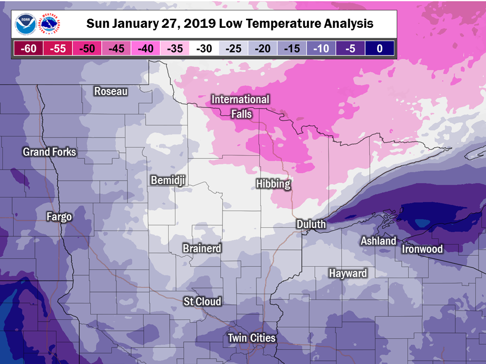
...RECORD DAILY LOW TEMPERATURE SET AT HIBBING MN...

A NEW DAILY RECORD LOW TEMPERATURE OF -40 WAS SET AT HIBBING MN
JAN 27 2019.  THIS BEATS THE OLD RECORD OF -32 SET IN 1976 AND 1966.

THIS TIES THE 11TH COLDEST ALL TIME LOW TEMPERATURE IN STATION
HISTORY.  THE RECORD COLDEST TEMPERATURE IN STATION HISTORY IS
-50 SET IN 1996.
...RECORD LOW TEMPERATURE SET AT INTERNATIONAL FALLS MN...

A NEW DAILY RECORD LOW TEMPERATURE OF -46 DEGREES WAS SET AT
INTERNATIONAL FALLS MN JAN 27 2019. THIS BEATS THE OLD RECORD OF -36 SET
IN 1966, 1955 AND 1915.

THIS TIES THE 5TH COLDEST ALL TIME LOW TEMPERATURE IN STATION
HISTORY.  THE RECORD COLDEST TEMPERATURE IN STATION HISTORY IS -55
SET IN 1909.
Note: These low temperature reports come from a variety of sources with varying equipment and exposures. We thank all volunteer weather observers for their dedication. Not all data listed are considered official.
Location                     Temp      Time/Date       Lat/Lon
Kabetogama General Store     -49 F     0700 AM 01/27   48.41N/93.05W
5 NW Ash Lake                -48 F     0745 AM 01/27   48.29N/92.97W
Babbitt                      -46 F     0700 AM 01/27   47.71N/91.95W
5 E Seagull Lake             -46 F     0804 AM 01/27   48.12N/90.84W
Celina 2E                    -46 F     0830 AM 01/27   47.87N/93.03W
Brimson 2s                   -45 F     0745 AM 01/27   47.25N/91.86W
Embarrass                    -45 F     0800 AM 01/27   47.66N/92.20W
International Falls          -45 F     0738 AM 01/27   48.57N/93.40W
Crane Lake Airport           -44 F     0755 AM 01/27   48.26N/92.47W
2 NNW Cotton                 -44 F     0800 AM 01/27   47.21N/92.49W
7 E Effie                    -43 F     0545 AM 01/27   47.84N/93.49W
3E Orr                       -42 F     0600 AM 01/27   48.06N/92.75W
1 E Birchdale                -42 F     0615 AM 01/27   48.63N/94.07W
3 N Butternut                -41 F     0600 AM 01/27   46.05N/90.53W
5 S Ely                      -41 F     0804 AM 01/27   47.83N/91.84W
Gunflint Lake                -41 F     0700 AM 01/27   48.17N/90.89W
3 SW Orr                     -41 F     0808 AM 01/27   48.02N/92.85W
Skibo RAWS                   -41 F     0822 AM 01/27   47.49N/91.99W
2 NNE Bigfork                -40 F     0607 AM 01/27   47.78N/93.65W
Littlefork                   -40 F     0830 AM 01/27   48.40N/93.55W
Littlefork RAWS              -40 F     0808 AM 01/27   48.39N/93.56W
3 ENE Margie                 -40 F     0435 AM 01/27   48.13N/93.88W
S. Fork Kawishiwi River      -40 F     0830 AM 01/27   47.84N/91.70W
Note: These wind chill reports come from a variety of sources with varying equipment and exposures, and that not all locations that report temperature listed above have equipment to measure the wind, and thus there is no equivalent wind chill for some sites listed above. We thank all volunteer weather observers for their dedication. Not all data listed are considered official.
Location                   Wind Chill  Time/Date       Lat/Lon
Grand Marais Airport         -57 F     0756 AM 01/27   47.75N/90.34W
International Falls          -54 F     0826 AM 01/27   48.57N/93.40W
Bay Of Grand Marais          -51 F     0756 AM 01/27   47.75N/90.34W
1 E Birchdale                -49 F     0835 AM 01/27   48.63N/94.07W
Eveleth-Virginia Airport     -48 F     0356 AM 01/27   47.42N/92.50W
Cloquet Airport              -46 F     0615 AM 01/27   46.70N/92.50W
Chisholm-Hibbing Airport     -46 F     1253 AM 01/27   47.39N/92.84W
5 E Seagull Lake             -46 F     0804 AM 01/27   48.12N/90.84W
Walker Airport               -46 F     0355 AM 01/27   47.16N/94.65W
Fernberg RAWS                -45 F     0613 AM 01/27   47.95N/91.50W
4 W Grand Portage            -45 F     0744 AM 01/27   47.95N/89.78W
2 NNW Cotton                 -45 F     1215 AM 01/27   47.21N/92.49W
3 ENE Margie                 -45 F     1235 AM 01/27   48.13N/93.88W
2 WNW Palmers                -43 F     0544 AM 01/27   46.94N/91.90W
Grand Portage RWIS           -43 F     0820 AM 01/27   47.98N/89.68W
5 NW Ash Lake                -43 F     0845 AM 01/27   48.29N/92.97W
Crane Lake Airport           -42 F     0828 AM 01/27   48.26N/92.47W
5 S Ely                      -42 F     0104 AM 01/27   47.83N/91.84W
7 E Effie                    -42 F     0735 AM 01/27   47.84N/93.49W
Superior Airport             -42 F     0755 AM 01/27   46.69N/92.09W
3 NNE Hermantown             -41 F     0816 AM 01/27   46.86N/92.22W
Duluth Airport               -41 F     0755 AM 01/27   46.84N/92.21W
3 SW Orr                     -41 F     0808 AM 01/27   48.02N/92.85W
Skibo RAWS                   -41 F     0822 AM 01/27   47.49N/91.99W
2 NNE Bigfork                -40 F     0607 AM 01/27   47.78N/93.65W
Littlefork RAWS              -40 F     0808 AM 01/27   48.39N/93.56W
Two Harbors                  -40 F     0455 AM 01/27   47.05N/91.75W
January 28, 2019
Late Sunday, Jan 27 into Monday, Jan 28, snow fell across the Upper Midwest, which resulted in warmer temperatures. Temperatures and wind chills were not especially notable during this period.
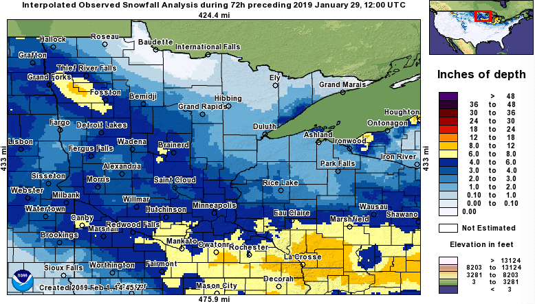
Image: Map of snowfall that occurred. (Snowfall Analysis courtesy NOHRSC.)
Observations are collected from a variety of sources with varying
equipment and exposures. We thank all volunteer weather observers
for their dedication. Not all data listed are considered official.
...SNOWFALL REPORTS FROM SUN JAN 27 THROUGH MORNING OF TUES JAN 29...

Location                     Amount    Time/Date       Lat/Lon
Silver Bay                   5.8 in    0700 AM 01/29   47.29N/91.30W
1 ENE Silver Bay             4.8 in    0800 AM 01/29   47.30N/91.26W
Bayfield 9N                  3.2 in    0700 AM 01/29   46.94N/90.83W
2 NW Duluth                  2.4 in    0734 PM 01/28   46.80N/92.15W
Bayfield Fish Hatchery       2.1 in    0800 AM 01/29   46.79N/90.86W
Spirit                       2.0 in    0400 AM 01/29   45.45N/90.10W
2 WNW Stone Lake             2.0 in    0700 AM 01/29   45.86N/91.58W
1 SW Bayfield                2.0 in    0700 AM 01/29   46.79N/90.84W
NWS Duluth                   1.6 in    1200 AM 01/29   46.84N/92.21W
1 N Moquah                   1.0 in    0600 AM 01/29   46.60N/91.08W
5 WSW Butternut              1.0 in    0630 AM 01/29   45.97N/90.60W
Babbitt                      1.0 in    0700 AM 01/29   47.71N/91.95W
14 W Isabella                1.0 in    0900 AM 01/29   47.59N/91.65W
January 29, 2019
On Tuesday, January 29, cold air returned to the Upper Midwest. While low temperatures were not especially notable, the strong winds gusting to 30-40+ mph resulting in very dangerous wind chills.
The map below represents an estimate of the low temperature, but locally colder values can and do occur - see the low temperature reports below for more details.
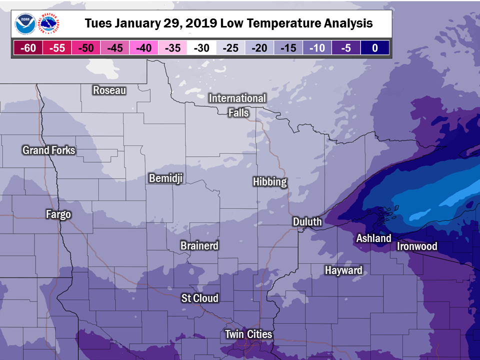
Note: These low temperature reports come from a variety of sources with varying equipment and exposures. We thank all volunteer weather observers for their dedication. Not all data listed are considered official.
Location                     Temp      Time/Date       Lat/Lon
1 E Birchdale                -27 F     0715 AM 01/29   48.63N/94.07W
3 SE Cotton                  -26 F     0600 AM 01/29   47.17N/92.42W
Littlefork RAWS              -25 F     0708 AM 01/29   48.39N/93.56W
3 ENE Margie                 -25 F     0704 AM 01/29   48.13N/93.88W
Northome                     -25 F     0700 AM 01/29   47.84N/94.26W
Cook                         -24 F     0735 AM 01/29   47.82N/92.69W
Northome                     -24 F     0715 AM 01/29   47.88N/94.25W
2 NNE Bigfork                -24 F     0707 AM 01/29   47.78N/93.65W
Northome RWIS                -24 F     0715 AM 01/29   47.60N/94.13W
7 E Effie                    -24 F     0715 AM 01/29   47.84N/93.49W
Orr                          -24 F     0733 AM 01/29   48.02N/92.87W
International Falls          -23 F     0655 AM 01/29   48.57N/93.40W
5 NW Ash Lake                -23 F     0715 AM 01/29   48.29N/92.97W
3 SW Orr                     -23 F     0708 AM 01/29   48.02N/92.85W
Babbitt                      -22 F     0700 AM 01/29   47.71N/91.95W
3 WSW Inger                  -22 F     0704 AM 01/29   47.54N/94.05W
3E Orr                       -22 F     0600 AM 01/29   48.06N/92.75W
Littlefork                   -22 F     0630 AM 01/29   48.40N/93.55W
16 E Buyck                   -22 F     0704 AM 01/29   48.12N/92.16W
9 ENE Deer River             -21 F     0145 AM 01/29   47.40N/93.62W
2 WNW Palmers                -21 F     0719 AM 01/29   46.94N/91.90W
Embarrass                    -21 F     0600 AM 01/29   47.66N/92.20W
Federal Dam 3 WNW            -21 F     0700 AM 01/29   47.25N/94.22W
Grand Rapids Airport         -21 F     0656 AM 01/29   47.22N/93.52W
Chisholm-Hibbing Airport     -21 F     0653 AM 01/29   47.39N/92.84W
1 WSW Virginia               -21 F     0715 AM 01/29   47.51N/92.53W
2 S Chisholm                 -21 F     0715 AM 01/29   47.45N/92.89W
Side Lake                    -21 F     0700 AM 01/29   47.68N/93.01W
Skibo RAWS                   -21 F     0722 AM 01/29   47.49N/91.99W
Bruno                        -21 F     0720 AM 01/29   46.28N/92.66W
Walker Airport               -21 F     0715 AM 01/29   47.16N/94.65W
Note: These wind chill reports come from a variety of sources with varying equipment and exposures, and that not all locations that report temperature listed above have equipment to measure the wind, and thus there is no equivalent wind chill for some sites listed above. We thank all volunteer weather observers for their dedication. Not all data listed are considered official.
Location                   Wind Chill  Time/Date       Lat/Lon
Chisholm-Hibbing Airport     -50 F     0731 AM 01/29   47.39N/92.84W
1 E Birchdale                -50 F     0645 AM 01/29   48.63N/94.07W
2 NNE Bigfork                -48 F     0707 AM 01/29   47.78N/93.65W
Grand Rapids Airport         -48 F     0656 AM 01/29   47.22N/93.52W
2 WNW Palmers                -47 F     0709 AM 01/29   46.94N/91.90W
International Falls          -47 F     0655 AM 01/29   48.57N/93.40W
Cook                         -46 F     0735 AM 01/29   47.82N/92.69W
Orr                          -46 F     0733 AM 01/29   48.02N/92.87W
Eveleth-Virginia Airport     -45 F     0735 AM 01/29   47.42N/92.50W
3 ENE Margie                 -45 F     0624 AM 01/29   48.13N/93.88W
Ely Airport                  -44 F     0716 AM 01/29   47.82N/91.83W
3 SW Orr                     -44 F     0708 AM 01/29   48.02N/92.85W
Cloquet Airport              -43 F     0715 AM 01/29   46.70N/92.50W
Northome                     -43 F     0715 AM 01/29   47.88N/94.25W
5 E Hibbing                  -43 F     0707 AM 01/29   47.39N/92.83W
Littlefork RAWS              -43 F     0708 AM 01/29   48.39N/93.56W
2 S Chisholm                 -43 F     0705 AM 01/29   47.45N/92.89W
5 SE Breezy Point            -42 F     0723 AM 01/29   46.55N/94.17W
McGregor Airport             -42 F     0716 AM 01/29   46.62N/93.31W
7 E Effie                    -42 F     0705 AM 01/29   47.84N/93.49W
Walker Airport               -42 F     0715 AM 01/29   47.16N/94.65W
3 NNE Hermantown             -41 F     0715 AM 01/29   46.86N/92.22W
Duluth Airport               -41 F     0655 AM 01/29   46.84N/92.21W
Makinen                      -40 F     0701 AM 01/29   47.36N/92.36W
5 S Ely                      -40 F     0704 AM 01/29   47.83N/91.84W
1 S Hill City                -40 F     0707 AM 01/29   46.96N/93.60W
4 S Emily                    -40 F     0705 AM 01/29   46.69N/93.95W
3 WNW Twig                   -40 F     0715 AM 01/29   46.92N/92.41W
Bruno                        -40 F     0705 AM 01/29   46.28N/92.66W
Longville Airport            -40 F     0719 AM 01/29   46.99N/94.20W
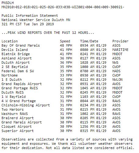
Note: These wind reports come from a variety of sources with varying equipment and exposures. Not all data listed are considered official.
Location                     Speed     Time/Date       Provider
Bay Of Grand Marais          48 MPH    0934 AM 01/29   ASOS
Devils Island                41 MPH    0800 AM 01/29   MARITIME
Blatnik Bridge               41 MPH    0241 PM 01/29   MNDOT
Ashland Airport              36 MPH    0127 PM 01/29   ASOS
Duluth Airport               36 MPH    1028 AM 01/29   NWS
2 SE Bayfield                35 MPH    1000 AM 01/29   CWOP
Federal Dam 6 SW             35 MPH    0700 AM 01/29   HADS
Northome                     33 MPH    0930 AM 01/29   CWOP
1 E Duluth                   32 MPH    0212 PM 01/29   NWLON
Grand Rapids Airport         32 MPH    0931 AM 01/29   AWOS
Grand Portage RWIS           32 MPH    1045 AM 01/29   MNDOT
Duluth RWIS                  32 MPH    0245 PM 01/29   MNDOT
1 W Bayfield                 31 MPH    1103 AM 01/29   CWOP
4 W Grand Portage            31 MPH    0844 AM 01/29   RAWS
Chisholm-Hibbing Airport     31 MPH    0234 PM 01/29   ASOS
Two Harbors                  31 MPH    0215 PM 01/29   AWOS
Washburn RAWS                31 MPH    1002 AM 01/29   RAWS
Brainerd Airport             30 MPH    0205 PM 01/29   ASOS
Grand Marais Airport         30 MPH    0115 PM 01/29   AWOS
Cloquet Airport              30 MPH    1256 PM 01/29   AWOS
Superior Airport             30 MPH    0315 PM 01/29   AWOS
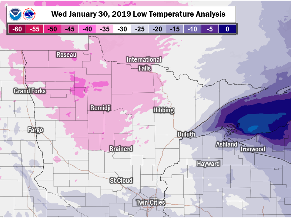
January 30, 2019
On Wednesday, January 30, the worst of the wind chills occurred. Most schools and even some businesses were closed, and the USPS suspended mail delivery across much of Minnesota and Wisconsin.
The map below represents an estimate of the low temperature, but locally colder values can and do occur - see the low temperature reports below for more details.
...RECORD COLDEST HIGH TEMPERATURE SET AT DULUTH MN JAN 30 2019...

A RECORD COLDEST HIGH TEMPERATURE OF -14 DEGREES WAS SET AT
DULUTH MN YESTERDAY. THIS BREAKS THE OLD RECORD OF -11
SET IN 1887.
...RECORD LOW TEMPERATURE AND COLDEST HIGH TEMPERATURE SET AT
INTERNATIONAL FALLS MN JAN 30 2019...

A RECORD LOW TEMPERATURE OF -40 DEGREES WAS SET AT
INTERNATIONAL FALLS MN JAN 30 2019. THIS TIES THE OLD RECORD OF -40
SET IN 1950.

A RECORD COLDEST HIGH TEMPERATURE OF -19 DEGREES WAS SET AT
INTERNATIONAL FALLS MN JAN 30 2019. THIS BREAKS THE OLD RECORD OF -14
SET IN 1909.
...RECORD LOW TEMPERATURE AND COLDEST HIGH TEMPERATURE SET AT
HIBBING MN JAN 30 2019...

A RECORD LOW TEMPERATURE OF -34 DEGREES WAS SET AT HIBBING MN
JAN 30 2019. THIS BREAKS THE OLD RECORD OF -33 SET IN 1951.

A RECORD COLDEST HIGH TEMPERATURE OF -17 DEGREES WAS SET AT
HIBBING MN JAN 30 2019. THIS BREAKS THE OLD RECORD OF -11
SET IN 1996.
...RECORD COLDEST HIGH TEMPERATURE SET AT BRAINERD MN JAN 30 2019...

A RECORD COLDEST HIGH TEMPERATURE OF -16 DEGREES WAS SET AT
BRAINERD MN JAN 30 2019. THIS BREAKS THE OLD RECORD OF -12
SET IN 1996.
...RECORD COLDEST HIGH TEMPERATURE SET AT ASHLAND WI JAN 30 2019...

A RECORD COLDEST HIGH TEMPERATURE OF -9 DEGREES WAS SET AT
ASHLAND WI JAN 30 2019. THIS BREAKS THE OLD RECORD OF -4
SET IN 1918.
Note: These low temperature reports come from a variety of sources with varying equipment and exposures. We thank all volunteer weather observers for their dedication. Not all data listed are considered official.
Location                     Temp      Time/Date
3 SE Cotton                  -43 F     0600 AM 01/30
Kabetogama General Store     -42 F     0700 AM 01/30
3 N Butternut                -40 F     0600 AM 01/30
Northome                     -39 F     0815 AM 01/30
Brimson 2s                   -38 F     0730 AM 01/30
1 SW Breezy Point            -38 F     0822 AM 01/30
3 ENE Margie                 -38 F     0744 AM 01/30
Celina 2E                    -38 F     0800 AM 01/30
Walker Airport               -38 F     0815 AM 01/30
Cass Lake DNR                -37 F     0801 AM 01/30
Cass Lake                    -37 F     0800 AM 01/30
3 WSW Inger                  -37 F     0804 AM 01/30
2 NNE Bigfork                -37 F     0807 AM 01/30
1 E Birchdale                -37 F     0820 AM 01/30
Northome RWIS                -37 F     0840 AM 01/30
7 E Effie                    -37 F     0805 AM 01/30
1 E Birchdale                -37 F     0700 AM 01/30
Bruno                        -37 F     0825 AM 01/30
Aitkin Airport               -36 F     0755 AM 01/30
2 NE Jenkins                 -36 F     0443 AM 01/30
5 SE Breezy Point            -36 F     0823 AM 01/30
Federal Dam 3 WNW            -36 F     0815 AM 01/30
4 N Floodwood                -36 F     0830 AM 01/30
Grand Rapids Airport         -36 F     0656 AM 01/30
1 S Hill City                -36 F     0807 AM 01/30
International Falls          -36 F     0755 AM 01/30
Littlefork RAWS              -36 F     0808 AM 01/30
4 S Emily                    -36 F     0815 AM 01/30
2 W Schley                   -36 F     0830 AM 01/30
5 NW Ash Lake                -36 F     0745 AM 01/30
Pine River Airport           -36 F     0815 AM 01/30
Longville Airport            -36 F     0809 AM 01/30
Note: These wind chill reports come from a variety of sources with varying equipment and exposures, and that not all locations that report temperature listed above have equipment to measure the wind, and thus there is no equivalent wind chill for some sites listed above. We thank all volunteer weather observers for their dedication. Not all data listed are considered official.
Location                   Wind Chill  Time/Date
2 WNW Palmers                -64 F     0844 AM 01/30
Grand Rapids Airport         -64 F     0656 AM 01/30
Chisholm-Hibbing Airport     -64 F     0753 AM 01/30
Cloquet Airport              -62 F     0836 AM 01/30
2 S Chisholm                 -61 F     0420 AM 01/30
Bruno                        -61 F     0845 AM 01/30
Northome                     -60 F     0845 AM 01/30
Walker Airport               -60 F     1035 PM 01/29
Duluth Airport               -59 F     0855 AM 01/30
Longville Airport            -59 F     0303 AM 01/30
5 SE Breezy Point            -58 F     0823 AM 01/30
2 NNE Bigfork                -58 F     0707 AM 01/30
1 S Hill City                -58 F     0707 AM 01/30
1 E Birchdale                -58 F     0815 AM 01/30
Orr                          -58 F     0633 AM 01/30
Aitkin Airport               -57 F     0416 AM 01/30
2 W Woodrow                  -57 F     1106 PM 01/29
Brainerd Airport             -57 F     0953 PM 01/29
Eveleth-Virginia Airport     -57 F     0515 AM 01/30
5 E Hibbing                  -57 F     0807 AM 01/30
3 ENE Margie                 -57 F     0734 AM 01/30
2 SW Proctor                 -57 F     0815 AM 01/30
Pine River Airport           -57 F     0956 PM 01/29
Two Harbors                  -57 F     0815 AM 01/30
Cook                         -56 F     0916 AM 01/30
4 S Emily                    -56 F     0245 AM 01/30
7 E Effie                    -56 F     0840 AM 01/30
2 NNW Cotton                 -56 F     0635 AM 01/30
Blatnik Bridge               -56 F     0605 AM 01/30
3 SW Orr                     -56 F     0708 AM 01/30
Sturgeon Lake                -56 F     0835 AM 01/30
Grand Marais Airport         -55 F     0156 AM 01/30
Fernberg RAWS                -55 F     0813 AM 01/30
International Falls          -55 F     0855 AM 01/30
2 WNW Duluth                 -55 F     0900 AM 01/30
5 NW Ash Lake                -55 F     0845 AM 01/30
Rice Lake N.W.R.             -55 F     0152 AM 01/30
2 W Mission                  -54 F     0844 AM 01/30
McGregor Airport             -54 F     0355 AM 01/30
Littlefork RAWS              -54 F     0508 AM 01/30
3 WNW Twig                   -54 F     0345 AM 01/30
1 SW Saginaw                 -54 F     0708 AM 01/30
Superior Airport             -54 F     0735 AM 01/30
1 NNW Cloquet                -53 F     0844 AM 01/30
1 SSW Jacobson               -53 F     0545 AM 01/30
3 W Clam Lake                -52 F     0820 AM 01/30
3 NNE Hermantown             -52 F     0900 AM 01/30
Moose Lake Airport           -52 F     0855 AM 01/30
2 SW Moose Lake              -52 F     0608 AM 01/30
Cass Lake DNR                -51 F     0901 AM 01/30
1 E Duluth                   -51 F     0812 AM 01/30
Makinen                      -51 F     0601 AM 01/30
1 W Isabella                 -51 F     0604 AM 01/30
Duluth RWIS                  -51 F     0745 AM 01/30
Washburn RAWS                -51 F     0802 AM 01/30
Ashland Airport              -50 F     0753 AM 01/30
Silver Bay                   -50 F     0835 AM 01/30
6 WSW Beaver Bay             -50 F     0835 AM 01/30
3 NW Superior                -50 F     0645 AM 01/30
Siren                        -50 F     1055 PM 01/29
Skibo RAWS                   -50 F     0622 AM 01/30
Hinckley Airport             -49 F     0635 AM 01/30
Crane Lake Airport           -49 F     0908 AM 01/30
5 S Ely                      -49 F     0904 AM 01/30
Glidden                      -49 F     1134 PM 01/29
Bay Of Grand Marais          -49 F     0356 AM 01/30
1 SW Breezy Point            -48 F     0347 AM 01/30
Walker                       -48 F     1000 PM 01/29
2 WSW Castle Danger          -48 F     0805 AM 01/30
3 ENE South Range            -47 F     0915 AM 01/30
2 ENE Duluth                 -47 F     0616 AM 01/30
Hayward Airport              -47 F     0853 AM 01/30
16 E Buyck                   -47 F     0804 AM 01/30
7 WNW Minong                 -47 F     0803 AM 01/30
6 ESE Cloverdale             -47 F     0915 AM 01/30
5 WSW Spirit                 -46 F     0845 AM 01/30
1 ESE Esko                   -46 F     0731 AM 01/30
Hayward RAWS                 -46 F     0903 AM 01/30
Phillips                     -46 F     0555 AM 01/30
6 SSW Springstead            -46 F     0147 AM 01/30
1 WSW Maple                  -45 F     0415 AM 01/30
3 E Namekagon                -44 F     0602 AM 01/30
4 SSE South Range            -44 F     0730 AM 01/30
2 ENE Oliver                 -44 F     0845 PM 01/29
Barnes                       -43 F     0506 AM 01/30
Glidden RAWS                 -43 F     0600 AM 01/30
4 W Grand Portage            -43 F     0444 AM 01/30
3 NE Randall                 -43 F     0906 AM 01/30
Grand Portage RWIS           -42 F     0410 AM 01/30
5 E Seagull Lake             -42 F     0804 AM 01/30
2 NE Duluth                  -40 F     0706 AM 01/30
Devils Island                -40 F     0300 AM 01/30
1 E Odanah                   -40 F     0845 AM 01/30
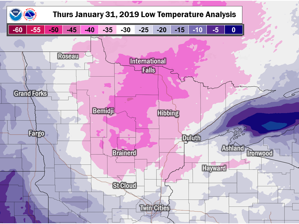
January 31, 2019
The coldest temperatures of this arctic outbreak occurred on the morning of Thursday, January 31 as the area of high pressure moved across the Upper Midwest, skies cleared out, and winds went calm.
The map below represents an estimate of the low temperature, but locally colder values can and do occur - see the low temperature reports below for more details.
...RECORD LOW DAILY TEMPERATURE SET AT INTERNATIONAL FALLS...

 A RECORD LOW DAILY TEMPERATURE OF -45 DEGREES WAS SET AT
INTERNATIONAL FALLS JAN 31 2019. THIS BREAKS THE OLD RECORD
OF -35 SET IN 1996.
Note: These low temperature reports come from a variety of sources with varying equipment and exposures. We thank all volunteer weather observers for their dedication. Not all data listed are considered official. (**Note about Cotton - this measurement occurred after the observer's normal observation time for the morning of January 31, 2019.)
Location                     Temp      Time/Date
3 SE Cotton                  -56 F     0715 AM 01/31 **See Note Above**
Kabetogama General Store     -50 F     0700 AM 01/31
Brimson 2s                   -47 F     0800 AM 01/31
3 N Butternut                -47 F     0600 AM 01/31
Celina 2E                    -47 F     0800 AM 01/31
2 NNE Bigfork                -46 F     0707 AM 01/31
7 E Effie                    -46 F     0745 AM 01/31
1 S Hill City                -45 F     0707 AM 01/31
International Falls          -45 F     0755 AM 01/31
4 S Emily                    -45 F     0630 AM 01/31
Northome RWIS                -45 F     0710 AM 01/31
1 SSW Jacobson               -45 F     0745 AM 01/31
5 NW Ash Lake                -45 F     0805 AM 01/31
Northome                     -45 F     0700 AM 01/31
Cass Lake DNR                -44 F     0701 AM 01/31
Cass Lake                    -44 F     0800 AM 01/31
3 WSW Inger                  -44 F     0704 AM 01/31
4 N Floodwood                -44 F     0830 AM 01/31
1 E Birchdale                -44 F     0745 AM 01/31
Brainerd Airport             -43 F     0322 AM 01/31
2 NNW Cotton                 -43 F     0740 AM 01/31
3 ENE Margie                 -43 F     0619 AM 01/31
3 S Tower                    -43 F     0730 AM 01/31
Babbitt                      -42 F     0700 AM 01/31
Brainerd                     -42 F     0700 AM 01/31
Crane Lake Airport           -42 F     0755 AM 01/31
Embarrass                    -42 F     0600 AM 01/31
14 W Isabella                -42 F     0900 AM 01/31
3E Orr                       -42 F     0600 AM 01/31
Littlefork RAWS              -42 F     0708 AM 01/31
3 NE Randall                 -42 F     0706 AM 01/31
6 ESE Cloverdale             -42 F     0715 AM 01/31
2 W Woodrow                  -41 F     0706 AM 01/31
1 SW Breezy Point            -41 F     0647 AM 01/31
Federal Dam 3 WNW            -41 F     0745 AM 01/31
Grand Rapids Airport         -41 F     0656 AM 01/31
2 W Schley                   -41 F     0645 AM 01/31
2 SW Moose Lake              -41 F     0708 AM 01/31
3 SW Orr                     -41 F     0808 AM 01/31
Rice Lake N.W.R.             -41 F     0752 AM 01/31
Libby                        -41 F     0800 AM 01/31
2 NE Jenkins                 -40 F     0843 AM 01/31
5 SE Breezy Point            -40 F     0743 AM 01/31
Northome                     -40 F     0702 AM 01/31
Gunflint Lake                -40 F     0700 AM 01/31
Chisholm-Hibbing Airport     -40 F     0753 AM 01/31
3 WNW Twig                   -40 F     0745 AM 01/31
5 E Seagull Lake             -40 F     0804 AM 01/31
S. Fork Kawishiwi River      -40 F     0800 AM 01/31
3 E Wright                   -40 F     0600 AM 01/31
Note: These wind chill reports come from a variety of sources with varying equipment and exposures, and that not all locations that report temperature listed above have equipment to measure the wind, and thus there is no equivalent wind chill for some sites listed above. We thank all volunteer weather observers for their dedication. Not all data listed are considered official.
Location                   Wind Chill  Time/Date
Grand Marais Airport         -59 F     0615 AM 01/31
2 WNW Palmers                -54 F     0744 AM 01/31
3 W Clam Lake                -53 F     0450 AM 01/31
Grand Rapids Airport         -53 F     0656 AM 01/31
2 NNW Cotton                 -53 F     0130 AM 01/31
2 S Chisholm                 -53 F     0410 AM 01/31
Brainerd Airport             -52 F     0438 AM 01/31
Cloquet Airport              -52 F     0656 AM 01/31
Fernberg RAWS                -52 F     0413 AM 01/31
Ashland Airport              -51 F     0753 AM 01/31
Duluth Airport               -51 F     0455 AM 01/31
Blatnik Bridge               -51 F     0736 AM 01/31
3 NNE Hermantown             -50 F     0617 AM 01/31
Chisholm-Hibbing Airport     -50 F     0326 AM 01/31
International Falls          -50 F     0955 PM 01/30
1 E Birchdale                -50 F     0840 AM 01/31
2 SW Proctor                 -50 F     0805 AM 01/31
5 E Hibbing                  -49 F     0707 AM 01/31
Two Harbors                  -49 F     0435 AM 01/31
Washburn RAWS                -49 F     0702 AM 01/31
Cook                         -48 F     1055 PM 01/30
Eveleth-Virginia Airport     -48 F     1155 PM 01/30
1 W Isabella                 -48 F     0104 AM 01/31
2 WNW Duluth                 -48 F     0445 AM 01/31
Grand Portage RWIS           -48 F     0820 AM 01/31
7 WNW Minong                 -48 F     0703 AM 01/31
Moose Lake Airport           -48 F     0736 AM 01/31
Superior Airport             -48 F     0715 AM 01/31
Walker Airport               -48 F     1155 PM 01/30
1 E Duluth                   -47 F     0724 AM 01/31
5 S Ely                      -47 F     0404 AM 01/31
4 W Grand Portage            -47 F     0544 AM 01/31
1 NNW Cloquet                -46 F     0314 AM 01/31
2 NNE Bigfork                -46 F     0707 AM 01/31
Glidden                      -46 F     0414 AM 01/31
Duluth RWIS                  -46 F     0845 AM 01/31
1 SW Saginaw                 -46 F     0408 AM 01/31
Northome                     -45 F     1030 PM 01/30
1 S Hill City                -45 F     0707 AM 01/31
3 WNW Twig                   -45 F     0440 AM 01/31
Orr                          -45 F     1013 PM 01/30
Phillips                     -45 F     0555 AM 01/31
Bruno                        -45 F     0125 AM 01/31
Cass Lake DNR                -44 F     0701 AM 01/31
3 WSW Inger                  -44 F     0704 AM 01/31
Makinen                      -44 F     0317 AM 01/31
1 SSW Jacobson               -44 F     0535 AM 01/31
7 E Effie                    -44 F     0930 PM 01/30
3 ENE Margie                 -44 F     0104 AM 01/31
McGregor Airport             -43 F     1155 PM 01/30
4 S Emily                    -43 F     0805 AM 01/31
Northome RWIS                -43 F     0815 AM 01/31
5 NW Ash Lake                -43 F     0830 AM 01/31
2 WSW Castle Danger          -43 F     1245 AM 01/31
3 SW Orr                     -43 F     1008 PM 01/30
2 W Woodrow                  -42 F     0906 PM 01/30
Crane Lake Airport           -42 F     0755 AM 01/31
2 SE Bayfield                -42 F     0846 AM 01/31
5 WSW Spirit                 -42 F     0317 AM 01/31
Devils Island                -42 F     0900 AM 01/31
Glidden RAWS                 -42 F     0900 AM 01/31
Hayward Airport              -42 F     0753 AM 01/31
Littlefork RAWS              -42 F     0708 AM 01/31
3 NE Randall                 -42 F     0706 AM 01/31
3 NW Superior                -42 F     0320 AM 01/31
6 ESE Cloverdale             -42 F     0715 AM 01/31
1 SW Breezy Point            -41 F     0647 AM 01/31
Bayfield                     -41 F     0846 AM 01/31
Grand Portage                -41 F     0816 AM 01/31
2 W Schley                   -41 F     0645 AM 01/31
2 SW Moose Lake              -41 F     0708 AM 01/31
Rice Lake N.W.R.             -41 F     0752 AM 01/31
5 E Seagull Lake             -41 F     0104 AM 01/31
Aitkin Airport               -40 F     1055 PM 01/30
2 NE Jenkins                 -40 F     0843 AM 01/31
5 SE Breezy Point            -40 F     0743 AM 01/31
2 ENE Duluth                 -40 F     0702 AM 01/31
1 ENE La Pointe              -40 F     0655 AM 01/31
4 ENE Two Harbors            -40 F     0800 AM 01/31
2 ENE Oliver                 -40 F     0900 AM 01/31
Longville Airport            -40 F     0950 PM 01/30
Environmental Analysis
An Arctic airmass moved into the area on Tuesday on the heels of a shortwave that brought a brief period of light snow to parts of central Minnesota and Wisconsin. The airmass originated over the Northwest Territories of Canada, where surface temperatures were in the 20 to 30 below zero range, with widespread significant snow depths. This initial shortwave and surface low pressure system brought snowfall amounts of up to 4 inches to the Northland, with higher amounts to the west and south of the area, with the highest snowfall amounts from near Grand Forks southeast through southeast Minnesota into southern Wisconsin.
On the heels of this storm system, the area experienced strong gusty winds, with the strongest winds on Tuesday afternoon. Northwest winds gusted over 30 mph for several hours Tuesday, and remained fairly strong Tuesday night and Wednesday. These contributed to the dangerous wind chills Tuesday through Wednesday. Specific wind chill values are on each day's tab.
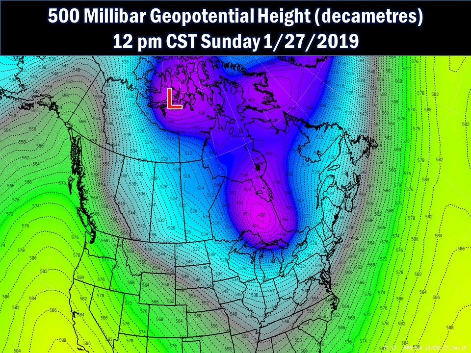
Aloft, the airmass was quite cold and deep. On the 500mb analysis ( about the middle of the atmosphere ) the core of the cold air moved from the Northwest Territories on Sunday, dropping south- southeast to over the Northland on Tuesday, then lingering through Wednesday. The coldest air shows as an area of lower Geopotential height values depicted in dark purple and blue, with the coldest area shown with a red L shape.
The core of cold air also showed at 850mb, which is an indication of what is going on in the lower atmosphere. The coldest air is depicted in pink and white, where temperatures were 30 to 40 below zero.
.net-gifmaker%20(2).gif)
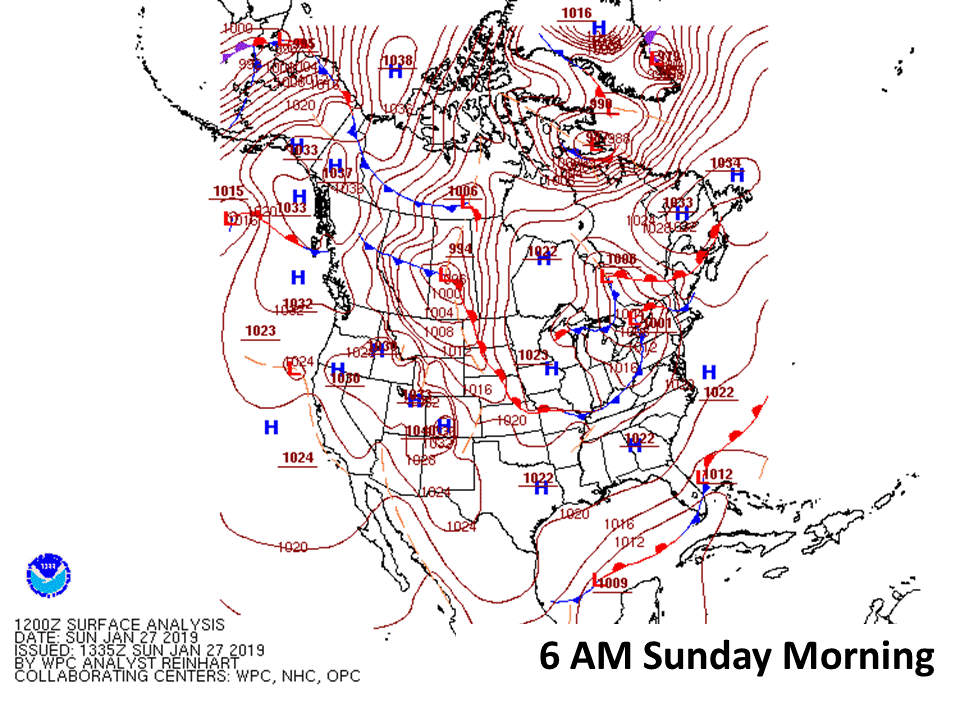
At the surface, a large area of high pressure also settled into the area, which allowed winds became light and variable for Wednesday night and Thursday, and temperatures fell too the coldest actual temperatures of the week.
 |
Media use of NWS Web News Stories is encouraged! Please acknowledge the NWS as the source of any news information accessed from this site. |
|

