Overview
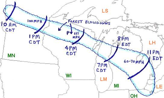
On the morning of July 4th, 1977, a derecho (pronounced "de·re·cho" and Spanish meaning "straight") or "a widespread and usually fast-moving windstorm associated with convection" took form over western Minnesota. This derecho continued in intensity as it moved for well over 12 hours across Minnesota, Wisconsin, Michigan and ending around 1:30 AM EDT on July 5th, 1977, in northern Ohio. At its peak, the winds were estimated to be 115 mph across portions of north central Wisconsin. For Minnesota, the highest winds reached 100 mph across the east central portion of the state around 1:00 PM CDT. In Michigan, the strongest winds were in the eastern portion of the state with 60-70 mph winds around 11:00 PM EDT.
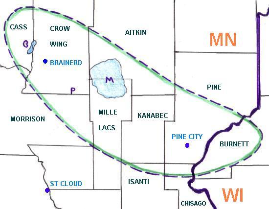
Within our forecast area, a swath of heavy wind damage stretched from southeastern Cass County, Gull Lake, Brainerd, Mille Lacs Lake, Pine City, and ending in western Burnett County in Wisconsin. The strong winds, estimated at 80 to 100 mph, knocked down trees, many onto cabins and cars.
Specifically, the Gull Lake Lodge had its roof blown off, a woman suffered a broken leg when winds overturned her mobile home in Platte Lake, and on Mille Lacs Lake, a resort lodge and many boats were completely destroyed. Observers noted eight to ten foot waves on Mille Lacs Lake with boat launches rocking on the water.
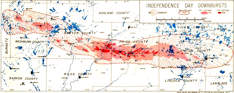
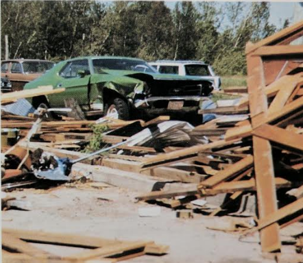
The worst damage was across northern Wisconsin in a swath extending from Burnett County into Washburn, Sawyer, Price, and Oneida Counties. This damage area measured between 10 to 20 miles wide and was over 160 miles long. In this region, 850,000 acres of trees were damaged or destroyed. Damage to personal property was at a cost of $24 million in 1977. A woman died when a tree fell on her camper van in Connor Lake. At 2:55 PM CDT, the storm reached the Phillips area where the airport recorded a wind speed of 100 mph before the instrument was blown away. In the city, all residences were damaged with thirty homes being beyond repair.
Mr. Sherburn Mabie, a longtime resident of the area, recalls the Phillips Derecho vividly. He and his family were picnicking 20 miles south of Phillips when they noticed the sky to the west was a terrible blue and greenish hue. Mabie stated, "The color of sky looked terrible in a blue, green color I have ever seen." They quickly rushed the kids and everyone into the house to bunker for protection from the storm. Mabie recalls that the wind did howl, but the extent of damage was minimal to those out in Phillips and the Connors Lake area. For him, and many other residents, one of the hardest things to come to grip with after the storm was the destruction and toppling of groves of virgin timber. The stands of virgin trees were a well-guarded treasure that the locals worked diligently to preserve from logging and subsequent development. For Mabie, it was the age old adage, "Nature taketh and giveth as she pleases.” With many years living and working in the region, Mabie knows the weather information and actions that are necessary to protect himself and his loved ones when dangerous weather approaches.
From Merceda Gehrke via Facebook posted June 24, 2017:
"We lived in the downtown area of Phillips at that time and had a pharmacy business on Main Street. The back of our building was pretty much gone when things settled down and took our electrical power with it. All that week the pharmacists filled prescriptions using a Coleman lantern to light the back of pharmacy as they typed the Rx labels on the big black typewriter. No computers in those days! it rained off and on during that week and water would come into the store via the air conditioning ducts.....so pails throughout the store! "
From Mark Stensvold via Facebook posted June 23, 2017:
[On one of the several small lakes in eastern Burnett County, Wisconsin] "my family was at our cabin - a 1940's building on posts - just ten feet from the lake. The wind was tremendous. Water from the lake blew around the windows, the cabin bounced, there was nothing to do but wait it out. When the wind stopped we went out to find dozens of trees down on the road out. I seem to remember cutting and hauling off the road about about thirty oak trees. That got us to the town road. Getting home to Spooner required frequent stops to cut and move trees. We might still be using that firewood at the cabin."
 |
 |
|
| Swath area and timing of the derecho on July 4, 1977. | Detailed map of the downburst damage across northern Wisconsin. |
 |
 |
|
| Map of downburst damage across Minnesota during the derecho. | Shaded areas represent strongest winds and resultant damage from the derecho. |
 |
 |
 |
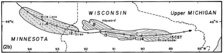
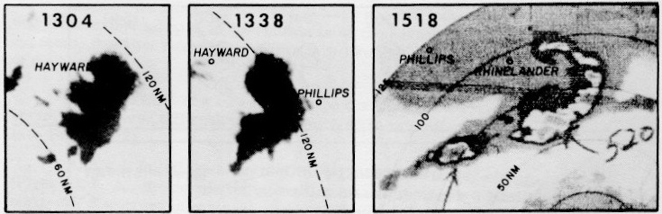
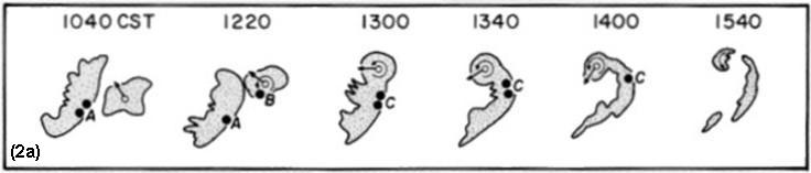
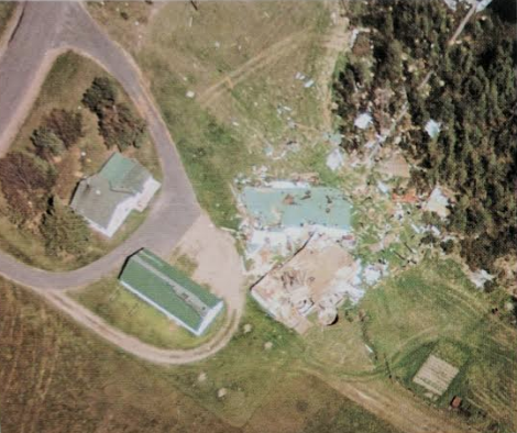
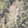
| Radar images with times in CST taken on July 4, 1977. | A barn near Phillips blown apart by the downburst. Immediately after the storm, local residents reported that they were hit by tornadoes. | Aerial photo of a burst swath caused by a "rotor microburst" at Northwood Beach, Wisconsin, on July 4, 1977. **NOTE** Fujita defined a "rotor microburst" as " a runaway vortex roll which leaves behind a band of wind damage." |
 |
 |
|
| Radar reflectivity evolution of the bow echo. | A barn near Phillips blown apart by the downburst. Immediately after the storm, local residents reported that they were hit by tornadoes. |
 |
 |
 |
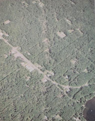
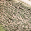
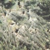
| Hundreds of trees in Sawyer County blown down by the northern Wisconsin macrobursts taken on July 4, 1977. | An intense microburst embedded inside of the northern Wisconsin macrobursts taken on July 4, 1977. | Aerial photo of a burst swath caused by a "rotor microburst" at Northwood Beach, Wisconsin on July 4, 1977. **NOTE** Fujita defined a "rotor microburst" as " a runaway vortex roll which leaves behind a band of wind damage." |
All photo credits go to Tetsuya Theodore "Ted" Fujita
Reference: "The Downburst," 1985, T. T. Fujita, published by the University of Chicago, Chicago, Illinois
 |
Media use of NWS Web News Stories is encouraged! Please acknowledge the NWS as the source of any news information accessed from this site. |
|

