Key Messages:
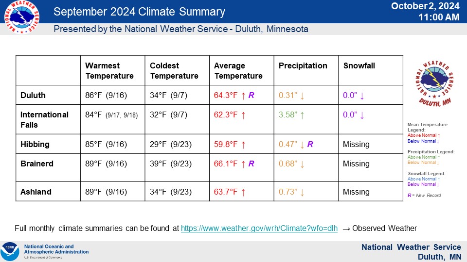
Duluth
857
CXUS53 KDLH 021400
CLMDLH

CLIMATE REPORT
NATIONAL WEATHER SERVICE DULUTH MN
900 AM CDT WED OCT 02 2024

...................................

...THE DULUTH CLIMATE SUMMARY FOR THE MONTH OF SEPTEMBER 2024...

CLIMATE NORMAL PERIOD: 1991 TO 2020
CLIMATE RECORD PERIOD: 1870 TO 2024

WEATHER         OBSERVED          NORMAL  DEPART   LAST YEAR'S
                VALUE   DATE(S)   VALUE   FROM     VALUE DATE(S)
                                          NORMAL
................................................................
TEMPERATURE (F)
RECORD
 HIGH             97   09/03/2023
 LOW              22   09/22/1974
                       09/26/1965
                       09/20/1962
HIGHEST           86   09/16         MM      MM       97  09/03
LOWEST            34   09/07         MM      MM       35  09/13
AVG. MAXIMUM    76.2               67.2     9.0     69.7
AVG. MINIMUM    52.5               47.3     5.2     54.1
MEAN            64.3               57.2     7.1     61.9
DAYS MAX >= 90     0                0.0     0.0        1
DAYS MAX <= 32     0                0.0     0.0        0
DAYS MIN <= 32     0                1.1    -1.1        0
DAYS MIN <= 0      0                0.0     0.0        0

PRECIPITATION (INCHES)
RECORD
 MAXIMUM       11.52   1881
 MINIMUM        0.19   1952
TOTALS          0.31               3.48   -3.17    10.36
DAILY AVG.      0.01               0.12   -0.11     0.35
DAYS >= .01        4               11.6    -7.6       14
DAYS >= .10        1                6.7    -5.7       10
DAYS >= .50        0                2.0    -2.0        5
DAYS >= 1.00       0                0.8    -0.8        4
GREATEST
 24 HR. TOTAL   0.16   09/21 TO 09/21

SNOWFALL (INCHES)
RECORDS
 TOTAL           2.4   1991
TOTALS           0.0                0.1    -0.1      0.0
SINCE 7/1        0.0                0.1    -0.1       MM
SNOWDEPTH AVG.     0                                   0
DAYS >= 1.0        0                0.0     0.0        0
GREATEST
 SNOW DEPTH        0                                   0  MM
 24 HR TOTAL     0.0

DEGREE DAYS
HEATING TOTAL     81                254    -173      155
 SINCE 7/1       134                366    -232       MM
COOLING TOTAL     70                 21      49       68
 SINCE 1/1       308                254      54       MM
................................................................

WIND (MPH)
AVERAGE WIND SPEED              7.9
HIGHEST WIND SPEED/DIRECTION    29/310    DATE  09/30
HIGHEST GUST SPEED/DIRECTION    47/300    DATE  09/30

SKY COVER
POSSIBLE SUNSHINE (PERCENT)   MM
AVERAGE SKY COVER           0.22
NUMBER OF DAYS FAIR           23
NUMBER OF DAYS PC              7
NUMBER OF DAYS CLOUDY          0

AVERAGE RH (PERCENT)     69

WEATHER CONDITIONS. NUMBER OF DAYS WITH
THUNDERSTORM              2     MIXED PRECIP               0
HEAVY RAIN                0     RAIN                       1
LIGHT RAIN                8     FREEZING RAIN              0
LT FREEZING RAIN          0     HAIL                       0
HEAVY SNOW                0     SNOW                       0
LIGHT SNOW                0     SLEET                      0
FOG                       9     FOG W/VIS <= 1/4 MILE      3
HAZE                      2

-  INDICATES NEGATIVE NUMBERS.
R  INDICATES RECORD WAS SET OR TIED.
MM INDICATES DATA IS MISSING.
T  INDICATES TRACE AMOUNT.

$$
International Falls
720
CXUS53 KDLH 021400
CLMINL

CLIMATE REPORT
NATIONAL WEATHER SERVICE DULUTH MN
900 AM CDT WED OCT 02 2024

...................................

...THE INTERNATIONAL FALLS CLIMATE SUMMARY FOR THE MONTH OF SEPTEMBER 2024...

CLIMATE NORMAL PERIOD: 1991 TO 2020
CLIMATE RECORD PERIOD: 1895 TO 2024

WEATHER         OBSERVED          NORMAL  DEPART   LAST YEAR'S
                VALUE   DATE(S)   VALUE   FROM     VALUE DATE(S)
                                          NORMAL
................................................................
TEMPERATURE (F)
RECORD
 HIGH             96   09/07/1906
 LOW              19   09/15/2011
HIGHEST           84   09/17         MM      MM       90  09/02
                       09/18
LOWEST            32   09/07         MM      MM       31  09/13
AVG. MAXIMUM    75.9               66.4     9.5     70.5
AVG. MINIMUM    48.7               42.0     6.7     47.7
MEAN            62.3               54.2     8.1     59.1
DAYS MAX >= 90     0                0.1    -0.1        1
DAYS MAX <= 32     0                0.0     0.0        0
DAYS MIN <= 32     1                4.6    -3.6        1
DAYS MIN <= 0      0                0.0     0.0        0

PRECIPITATION (INCHES)
RECORD
 MAXIMUM        7.36   1961
 MINIMUM        0.20   1897
TOTALS          3.58               3.00    0.58     3.14
DAILY AVG.      0.12               0.10    0.02     0.11
DAYS >= .01        7               12.2    -5.2        9
DAYS >= .10        4                6.1    -2.1        6
DAYS >= .50        2                1.7     0.3        2
DAYS >= 1.00       1                0.6     0.4        1
GREATEST
 24 HR. TOTAL   2.75   09/16 TO 09/17

SNOWFALL (INCHES)
RECORDS
 TOTAL           2.0   1912
TOTALS           0.0                0.1    -0.1      0.0
SINCE 7/1        0.0                0.1    -0.1       MM
SNOWDEPTH AVG.     0                                   0
DAYS >= 1.0        0                0.1    -0.1        0
GREATEST
 SNOW DEPTH        0                                   0  MM
 24 HR TOTAL     0.0

DEGREE DAYS
HEATING TOTAL    125                336    -211      185
 SINCE 7/1       207                527    -320       MM
COOLING TOTAL     51                 12      39       31
 SINCE 1/1       218                174      44       MM
................................................................

WIND (MPH)
AVERAGE WIND SPEED              5.3
HIGHEST WIND SPEED/DIRECTION    26/290    DATE  09/30
HIGHEST GUST SPEED/DIRECTION    45/280    DATE  09/30

SKY COVER
POSSIBLE SUNSHINE (PERCENT)   MM
AVERAGE SKY COVER           0.22
NUMBER OF DAYS FAIR           22
NUMBER OF DAYS PC              8
NUMBER OF DAYS CLOUDY          0

AVERAGE RH (PERCENT)     72

WEATHER CONDITIONS. NUMBER OF DAYS WITH
THUNDERSTORM              4     MIXED PRECIP               0
HEAVY RAIN                3     RAIN                       5
LIGHT RAIN                9     FREEZING RAIN              0
LT FREEZING RAIN          0     HAIL                       0
HEAVY SNOW                0     SNOW                       0
LIGHT SNOW                0     SLEET                      0
FOG                      12     FOG W/VIS <= 1/4 MILE      2
HAZE                      2

-  INDICATES NEGATIVE NUMBERS.
R  INDICATES RECORD WAS SET OR TIED.
MM INDICATES DATA IS MISSING.
T  INDICATES TRACE AMOUNT.

$$
Hibbing
719
CXUS53 KDLH 021400
CLMHIB

CLIMATE REPORT
NATIONAL WEATHER SERVICE DULUTH MN
900 AM CDT WED OCT 02 2024

...................................

...THE HIBBING CLIMATE SUMMARY FOR THE MONTH OF SEPTEMBER 2024...

CLIMATE NORMAL PERIOD: 1991 TO 2020
CLIMATE RECORD PERIOD: 1931 TO 2024

WEATHER         OBSERVED          NORMAL  DEPART   LAST YEAR'S
                VALUE   DATE(S)   VALUE   FROM     VALUE DATE(S)
                                          NORMAL
................................................................
TEMPERATURE (F)
RECORD
 HIGH             95   09/03/2023
 LOW              21   09/15/2011
                       09/29/1984
                       09/28/1967
HIGHEST           85   09/16         MM      MM       95  09/03
LOWEST            29   09/23         MM      MM       27  09/13
AVG. MAXIMUM    76.2               65.7    10.5     70.2
AVG. MINIMUM    43.4               40.3     3.1     48.1
MEAN            59.8               53.0     6.8     59.2
DAYS MAX >= 90     0                0.1    -0.1        3
DAYS MAX <= 32     0                0.0     0.0        0
DAYS MIN <= 32     2                5.7    -3.7        3
DAYS MIN <= 0      0                0.0     0.0        0

PRECIPITATION (INCHES)
RECORD
 MAXIMUM        8.67   1947
 MINIMUM        0.50   1952
TOTALS          0.47R              3.06   -2.59     6.62
DAILY AVG.      0.02               0.10   -0.08     0.22
DAYS >= .01        7               12.0    -5.0       14
DAYS >= .10        2                6.0    -4.0       10
DAYS >= .50        0                2.0    -2.0        4
DAYS >= 1.00       0                0.6    -0.6        3
GREATEST
 24 HR. TOTAL   0.15   09/05 TO 09/05
                       09/18 TO 09/19


DEGREE DAYS
HEATING TOTAL    172                369    -197      210
 SINCE 7/1       323                609    -286       MM
COOLING TOTAL     24                  9      15       44
 SINCE 1/1       137                120      17       MM
................................................................

WIND (MPH)
AVERAGE WIND SPEED              4.9
HIGHEST WIND SPEED/DIRECTION    25/310    DATE  09/30
HIGHEST GUST SPEED/DIRECTION    39/310    DATE  09/30

SKY COVER
POSSIBLE SUNSHINE (PERCENT)   MM
AVERAGE SKY COVER           0.25
NUMBER OF DAYS FAIR           22
NUMBER OF DAYS PC              7
NUMBER OF DAYS CLOUDY          1

AVERAGE RH (PERCENT)     69

WEATHER CONDITIONS. NUMBER OF DAYS WITH
THUNDERSTORM              2     MIXED PRECIP               0
HEAVY RAIN                3     RAIN                       1
LIGHT RAIN                8     FREEZING RAIN              0
LT FREEZING RAIN          0     HAIL                       0
HEAVY SNOW                0     SNOW                       0
LIGHT SNOW                0     SLEET                      0
FOG                      26     FOG W/VIS <= 1/4 MILE     14
HAZE                      1

-  INDICATES NEGATIVE NUMBERS.
R  INDICATES RECORD WAS SET OR TIED.
MM INDICATES DATA IS MISSING.
T  INDICATES TRACE AMOUNT.

$$
Brainerd
859
CXUS53 KDLH 021400
CLMBRD

CLIMATE REPORT
NATIONAL WEATHER SERVICE DULUTH MN
900 AM CDT WED OCT 02 2024

...................................

...THE BRAINERD CLIMATE SUMMARY FOR THE MONTH OF SEPTEMBER 2024...

CLIMATE NORMAL PERIOD: 1991 TO 2020
CLIMATE RECORD PERIOD: 1899 TO 2024

WEATHER         OBSERVED          NORMAL  DEPART   LAST YEAR'S
                VALUE   DATE(S)   VALUE   FROM     VALUE DATE(S)
                                          NORMAL
................................................................
TEMPERATURE (F)
RECORD
 HIGH            103   09/10/1931
 LOW              18   09/22/1974
HIGHEST           89   09/16         MM      MM      102  09/03
LOWEST            39   09/23         MM      MM       37  09/13
AVG. MAXIMUM    79.2               70.5     8.7     74.6
AVG. MINIMUM    53.1               46.9     6.2     55.0
MEAN            66.1               58.7     7.4     64.8
DAYS MAX >= 90     0                0.2    -0.2        3
DAYS MAX <= 32     0                0.0     0.0        0
DAYS MIN <= 32     0                1.5    -1.5        0
DAYS MIN <= 0      0                0.0     0.0        0

PRECIPITATION (INCHES)
RECORD
 MAXIMUM        8.04   1986
 MINIMUM        0.17   1952
TOTALS          0.68               2.60   -1.92     4.19
DAILY AVG.      0.02               0.09   -0.07     0.14
DAYS >= .01        4               10.9    -6.9       12
DAYS >= .10        2                4.9    -2.9        8
DAYS >= .50        0                1.7    -1.7        3
DAYS >= 1.00       0                0.5    -0.5        2
GREATEST
 24 HR. TOTAL   0.57   09/18 TO 09/19


DEGREE DAYS
HEATING TOTAL     60                223    -163       89
 SINCE 7/1        85                284    -199       MM
COOLING TOTAL    102                 34      68       91
 SINCE 1/1       506                411      95       MM
................................................................

WIND (MPH)
AVERAGE WIND SPEED              6.9
HIGHEST WIND SPEED/DIRECTION    28/220    DATE  09/19
                                28/200          09/30
HIGHEST GUST SPEED/DIRECTION    55/210    DATE  09/19

SKY COVER
POSSIBLE SUNSHINE (PERCENT)   MM
AVERAGE SKY COVER           0.13
NUMBER OF DAYS FAIR           28
NUMBER OF DAYS PC              2
NUMBER OF DAYS CLOUDY          0

AVERAGE RH (PERCENT)     67

WEATHER CONDITIONS. NUMBER OF DAYS WITH
THUNDERSTORM              3     MIXED PRECIP               0
HEAVY RAIN                1     RAIN                       2
LIGHT RAIN                5     FREEZING RAIN              0
LT FREEZING RAIN          0     HAIL                       0
HEAVY SNOW                0     SNOW                       0
LIGHT SNOW                0     SLEET                      0
FOG                      21     FOG W/VIS <= 1/4 MILE      6
HAZE                      4

-  INDICATES NEGATIVE NUMBERS.
R  INDICATES RECORD WAS SET OR TIED.
MM INDICATES DATA IS MISSING.
T  INDICATES TRACE AMOUNT.

$$
Ashland
858
CXUS53 KDLH 021400
CLMASX

CLIMATE REPORT
NATIONAL WEATHER SERVICE DULUTH MN
900 AM CDT WED OCT 02 2024

...................................

...THE ASHLAND CLIMATE SUMMARY FOR THE MONTH OF SEPTEMBER 2024...

CLIMATE NORMAL PERIOD: 1991 TO 2020
CLIMATE RECORD PERIOD: 1893 TO 2024

WEATHER         OBSERVED          NORMAL  DEPART   LAST YEAR'S
                VALUE   DATE(S)   VALUE   FROM     VALUE DATE(S)
                                          NORMAL
................................................................
TEMPERATURE (F)
RECORD
 HIGH            100   09/07/1976
 LOW              12   09/28/1893
HIGHEST           89   09/16         MM      MM       95  09/04
LOWEST            34   09/23         MM      MM       32  09/14
AVG. MAXIMUM    78.4               69.0     9.4     71.4
AVG. MINIMUM    49.0               45.8     3.2     52.2
MEAN            63.7               57.4     6.3     61.8
DAYS MAX >= 90     0                0.3    -0.3        3
DAYS MAX <= 32     0                0.0     0.0        0
DAYS MIN <= 32     0                2.0    -2.0        1
DAYS MIN <= 0      0                0.0     0.0        0

PRECIPITATION (INCHES)
RECORD
 MAXIMUM       10.00   1985
 MINIMUM        0.36   1939
TOTALS          0.73               3.03   -2.30     4.50
DAILY AVG.      0.02               0.10   -0.08     0.15
DAYS >= .01        7               12.7    -5.7       12
DAYS >= .10        2                6.5    -4.5        9
DAYS >= .50        0                1.8    -1.8        2
DAYS >= 1.00       0                0.6    -0.6        1
GREATEST
 24 HR. TOTAL   0.42   09/05 TO 09/05


DEGREE DAYS
HEATING TOTAL     97                253    -156      162
 SINCE 7/1       160                380    -220       MM
COOLING TOTAL     65                 25      40       71
 SINCE 1/1       309                257      52       MM
................................................................

WIND (MPH)
AVERAGE WIND SPEED              6.1
HIGHEST WIND SPEED/DIRECTION    30/280    DATE  09/30
HIGHEST GUST SPEED/DIRECTION    44/250    DATE  09/30

SKY COVER
POSSIBLE SUNSHINE (PERCENT)   MM
AVERAGE SKY COVER           0.22
NUMBER OF DAYS FAIR           22
NUMBER OF DAYS PC              7
NUMBER OF DAYS CLOUDY          1

AVERAGE RH (PERCENT)     72

WEATHER CONDITIONS. NUMBER OF DAYS WITH
THUNDERSTORM              2     MIXED PRECIP               0
HEAVY RAIN                3     RAIN                       2
LIGHT RAIN                6     FREEZING RAIN              0
LT FREEZING RAIN          0     HAIL                       0
HEAVY SNOW                0     SNOW                       0
LIGHT SNOW                0     SLEET                      0
FOG                      20     FOG W/VIS <= 1/4 MILE     12
HAZE                      0

-  INDICATES NEGATIVE NUMBERS.
R  INDICATES RECORD WAS SET OR TIED.
MM INDICATES DATA IS MISSING.
T  INDICATES TRACE AMOUNT.

$$
September Summary
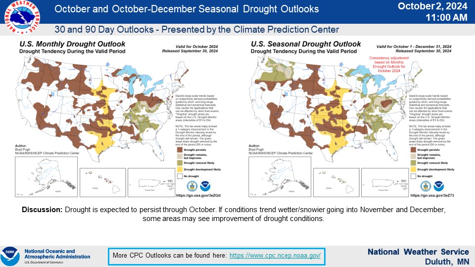
Drought/Hydro
Outlook

 |
Media use of NWS Web News Stories is encouraged! Please acknowledge the NWS as the source of any news information accessed from this site. |
|

