Overview
|
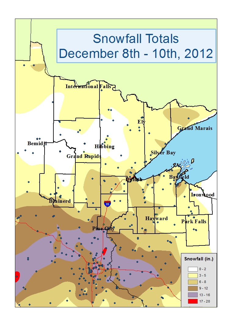
A low pressure system exited southeast South Dakota and tracked across southern Minnesota through the day Sunday, December 9th. Snow became widespread across the entire state of Minnesota through the early morning hours of the 9th, persisting into the evening for most areas. Snow lingered in the Minnesota Arrowhead region and across northern Wisconsin overnight. Impressive snowfall amounts were associated with this winter storm. Totals in excess of one foot were found over portions of central Minnesota into west central Wisconsin. By Sunday evening, the Northland saw snowfall amounts ranging from over 8 inches in southern Pine county, around 6 inches in the Brainerd to Aitkin area, and generally 5 to 6 inches across the Twin Ports. As the low pressure center moved southeastward through southern Minnesota and into Wisconsin, northwesterly winds allowed for additional lake effect snow along the southern shore of Lake Superior. Areas along the shore reached storm totals ranging from 6 to 12 inches for both the snow that fell on the 9th during the day and overnight and during the lake effect snow effect on the 10th. Interestingly...a relatively strong meso-vortex (relatively small area of circulation) formed in the general flow over the tip of Lake Superior, creating an area of heavy snow just along the north shore from Two Harbors to Silver Bay. The snow out of this atmospheric disturbance was falling at one inch per hour at one point. |
 |
Snowfall Reports
804
NOUS43 KDLH 101750
PNSDLH

PUBLIC INFORMATION STATEMENT
NATIONAL WEATHER SERVICE DULUTH MN
1135 AM CST MON DEC 10 2012


STORM TOTAL SNOWFALLS FROM LATE SATURDAY NIGHT THROUGH MONDAY
MORNING...12/8 THROUGH 12/9


SNOW REPORTS LISTED BY AMOUNT

 INCHES  LOCATION                 ST  COUNTY           TIME
 ------  -----------------------  --  --------------   -------
  9.20   MADELINE ISLAND          WI  ASHLAND          0541 AM
                 FELL OVERNIGHT. STILL SNOWING
  9.10   SARONA                   WI  WASHBURN         0603 AM
                 2.6 OVERNIGHT.
  8.50   1 SW BAYFIELD            WI  BAYFIELD         0855 AM
  8.10   MCGREGOR                 MN  AITKIN           0800 AM
  8.00   SARONA                   WI  WASHBURN         0800 AM
  8.00   BENNETT                  WI  DOUGLAS          0730 AM
  8.00   11 NW GRAND MARAIS       MN  COOK             0630 AM
  7.60   ASHLAND                  WI  ASHLAND          0745 AM
                 ALL FELL OVERNIGHT. BEGAN 1030 PM.
  7.50   5 WSW DULUTH             MN  ST. LOUIS        1000 PM
  7.30   DULUTH                   MN  ST. LOUIS        0650 AM
                 FINAL STORM TOTAL AT NATIONAL WEATHER SERVICE
  7.10   5 NW DULUTH              MN  ST. LOUIS        0606 AM
                 6.5 TOTAL AT MIDNIGHT. 0.6 INCHES SINCE
                 MIDNIGHT.
  7.00   3 E WRIGHT               MN  CARLTON          0900 AM
  7.00   3 E WRIGHT               MN  CARLTON          0607 AM
                 24 HOURS TOTAL
  6.80   5 S DANBURY              WI  BURNETT          0650 AM
  6.50   15 W SANDSTONE           MN  KANABEC          0745 AM
  6.00   SHELL LAKE               WI  WASHBURN         0745 AM
                 3 YESTERDAY/3 OVERNIGHT
  6.00   MOOSE LAKE               MN  CARLTON          0738 AM
  6.00   8 W PORT WING            WI  LSZ145           0700 AM
                 5 INCHES FELL OVERNIGHT. STILL SNOWING
                 LIGHTLY.
  6.00   HERTEL                   WI  BURNETT          0630 AM
  5.80   2 W HAYWARD              WI  SAWYER           0630 AM
                 MOST OF THE SNOW FELL YESTERDAY.
  5.80   MAPLE                    WI  DOUGLAS          0630 AM
                 TOTAL SINCE YESTERDAY. STILL SNOWING.
  5.20   BRAINERD                 MN  CROW WING        0800 AM
  5.20   4 E CORNUCOPIA           WI  BAYFIELD         0745 AM
  5.00   GORDON                   WI  DOUGLAS          0900 AM
  5.00   WEBB LAKE                WI  BURNETT          0800 AM
  5.00   CORNUCOPIA               WI  BAYFIELD         0630 AM
  4.90   HOLYOKE                  MN  CARLTON          0725 AM
  4.80   4 W WASHBURN             WI  BAYFIELD         0730 AM
                 TOTAL.
  4.50   12 N ISLE                MN  AITKIN           0630 AM
                 STORM TOTAL
  4.50   HAWTHORNE                WI  DOUGLAS          0612 AM
                 STILL SNOWING HEAVILY
  4.20   CLAM LAKE                MN  BURNETT          0630 AM
  4.00   PORT WING                WI  BAYFIELD         1100 AM
  4.00   6 W TWO HARBORS          MN  ST. LOUIS        0725 AM
  4.00   3 W PHILLIPS             WI  PRICE            0715 AM
  4.00   3 NE NISSWA              MN  CROW WING        0630 AM
  3.80   BEAVER BAY               MN  LAKE             0951 AM
  3.60   KABETOGAMA               MN  ST. LOUIS        0734 AM
                 2 DAY TOTAL
  3.60   KABETOGAMA               MN  ST. LOUIS        0700 AM
  3.50   7 E SUPERIOR             WI  LSZ145           0549 AM
                 UPDATED TOTAL.
  3.40   ISLAND LAKE              MN  ITASCA           0855 AM
  3.30   2 NW MELLEN              WI  ASHLAND          0800 AM
  3.30   SILVER BAY               MN  LAKE             0700 AM
  3.30   5 S HERBSTER             WI  BAYFIELD         0650 AM
                 MOST FELL OVERNIGHT
  3.20   BRUNO                    MN  PINE             0800 AM
  3.10   9 N BAYFIELD             WI  LSZ147           0630 AM
  3.00   GLIDDEN                  WI  ASHLAND          0733 AM
                 FELL OVERNIGHT
  3.00   CULVER                   MN  ST. LOUIS        0725 AM
  3.00   PARK FALLS               WI  PRICE            0700 AM
  3.00   ORR                      MN  ST. LOUIS        0613 AM
                 24 HOUR TOTAL
  2.90   6 S BIGFORK              MN  ITASCA           0951 AM
  2.80   BABBITT                  MN  ST. LOUIS        0800 AM
  2.60   INDUS                    MN  KOOCHICHING      0800 AM
  2.60   LITTLE MARAIS            MN  LAKE             0630 AM
  2.50   ELY                      MN  ST. LOUIS        0855 AM
  2.50   7 SE GRAND RAPIDS        MN  ITASCA           0733 AM
  2.00   GRAND PORTAGE            MN  COOK             0900 AM
  2.00   UPSON                    WI  IRON             0800 AM
  2.00   BUTTERNUT                WI  ASHLAND          0541 AM
                 OVER THE PAST 24 HOURS
  1.70   NORTHOME                 MN  KOOCHICHING      0630 AM
  1.60   FEDERAL DAM              MN  CASS             0900 AM
  1.60   GURNEY                   WI  IRON             0734 AM
  1.30   12 N GRAND RAPIDS        MN  ITASCA           0700 AM
  0.70   COTTON                   MN  ST. LOUIS        0600 AM

$$
 |
Media use of NWS Web News Stories is encouraged! Please acknowledge the NWS as the source of any news information accessed from this site. |
|

