Overview
|
On the afternoon of May 28, 2011, scattered thunderstorms developed across parts of the Northland, particularly northeast Minnesota. Some of these storms became severe. There were two storms in particular that were strongest. One tracked from near Brimson to near Silver Bay and the other tracked from 4 miles south of McGrath to the Twin Ports. |
 |
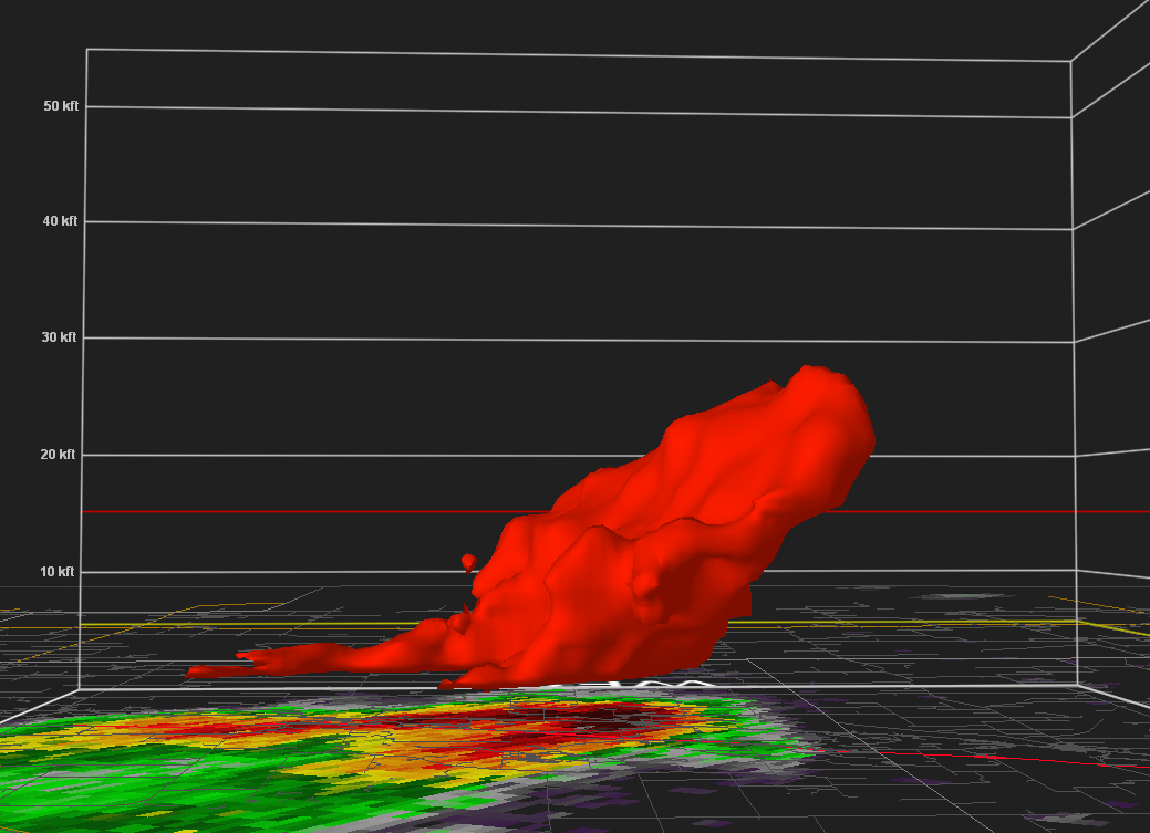 |
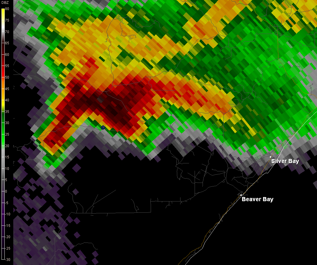
| The Brimson to Silver Bay storm approaching Silver Bay at 3:11 PM. | The McGrath to the Twin Ports storm 50 dBZ volume cross section at 5:34pm showing the tilt of the storm. |
Tornado:
|
Tornado - Southern Lake County, MN
Track Map 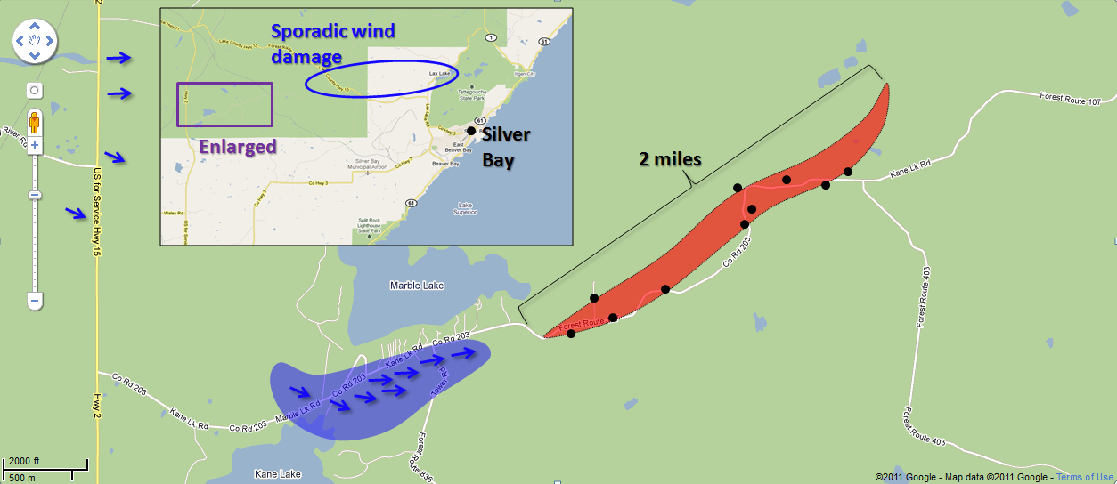
 |
||||||||||||||||
The Enhanced Fujita (EF) Scale classifies tornadoes into the following categories:
| EF0 Weak 65-85 mph |
EF1 Moderate 86-110 mph |
EF2 Significant 111-135 mph |
EF3 Severe 136-165 mph |
EF4 Extreme 166-200 mph |
EF5 Catastrophic 200+ mph |
 |
|||||
 |
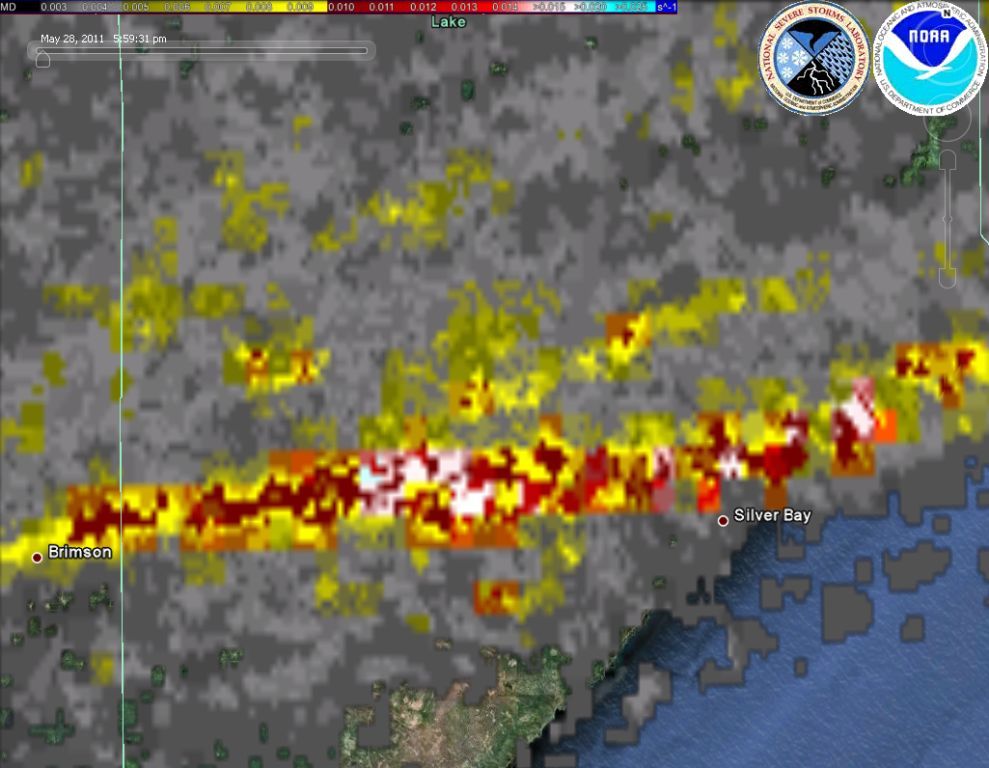 |
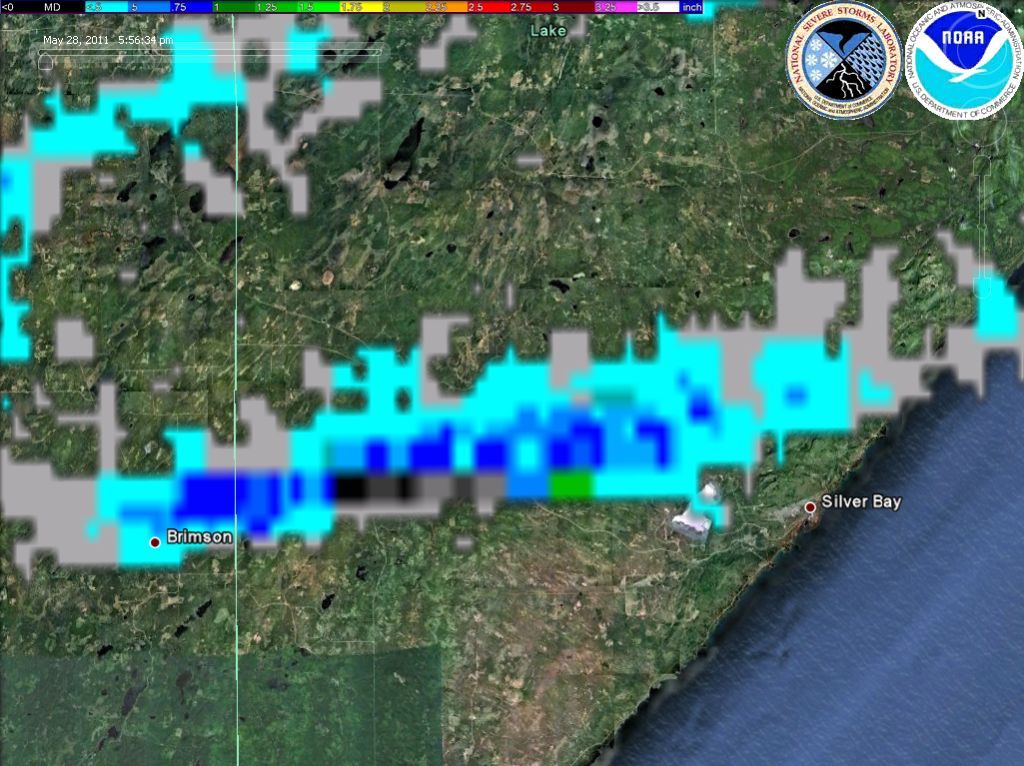
The image above left is a hail swath map from the National Severe Storms Laboratory (NSSL). This shows where an area of large hail likely fell, from just northeast of Brimson to the area north of Silver Bay. We did receive a quarter-size (1-inch diameter) hail report from north of Silver Bay, but the hail was likely a bit larger to the west. The image above right is a rotation track map from NSSL, which essentially shows where the strongest areas of rotation were. White colors indicate the strongest rotation, then red, then yellow. This map shows how the rotation increased in the storm as it moved into southern Lake County, and then passed north of Silver Bay.
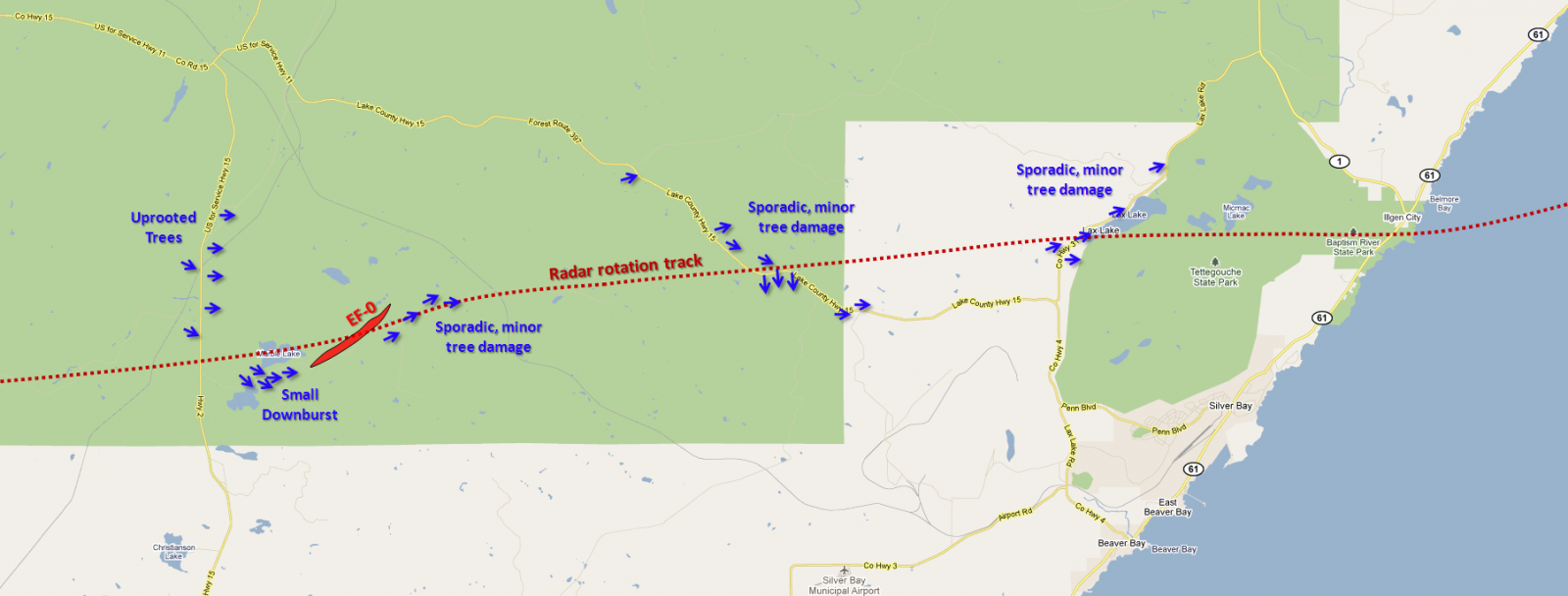
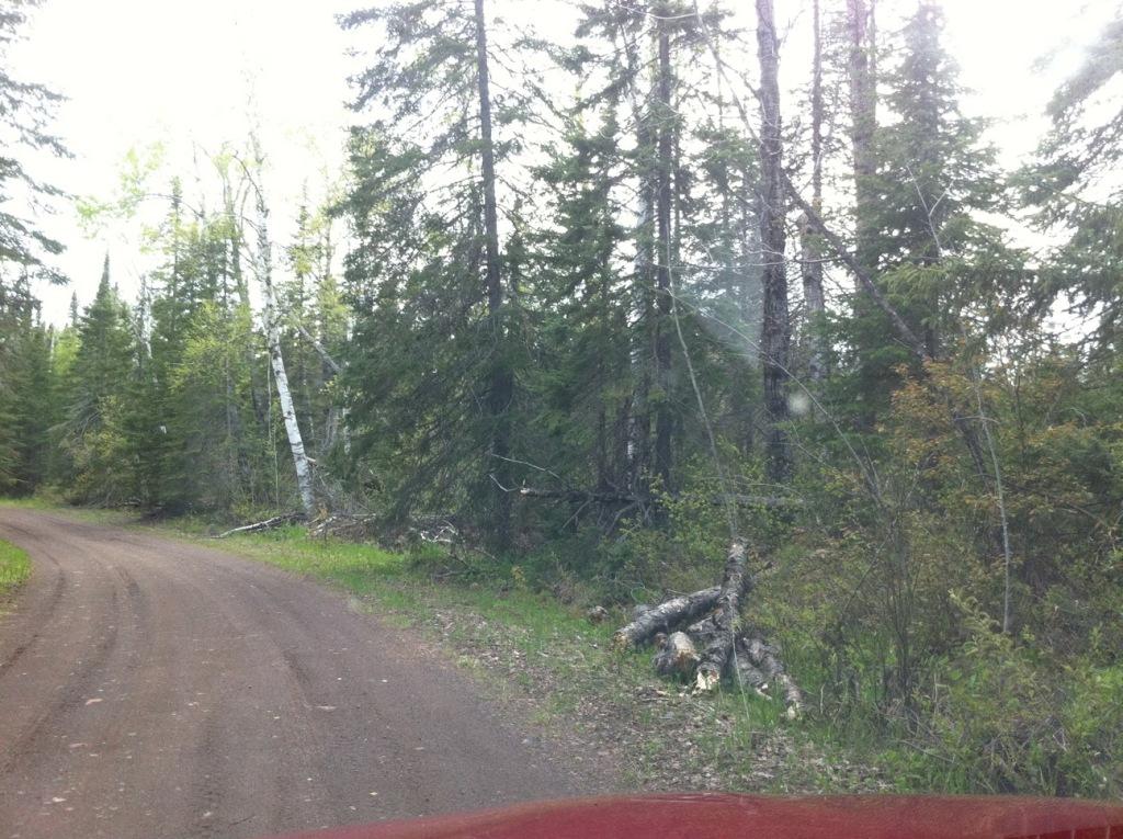
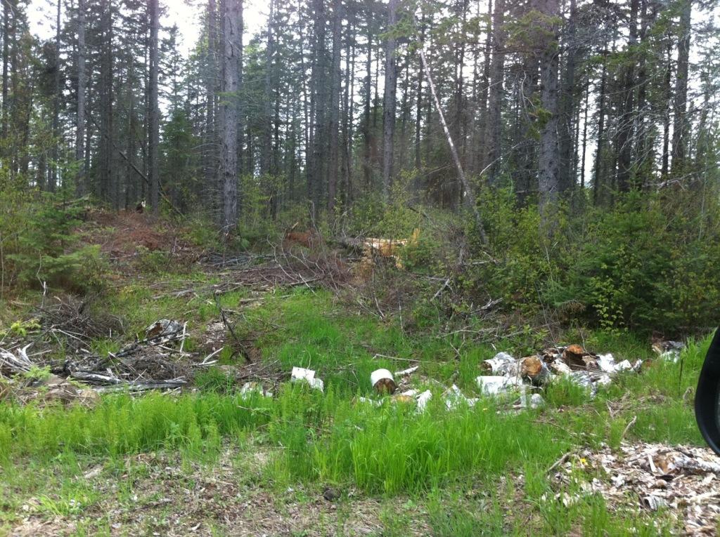
The storm mostly passed through southern portions of the Superior National Forest before crossing through Tettegouche State Park.
 |
 |
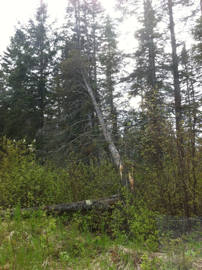 |
Above is a small sample of the tree damage. Some of the tree damage was mixed in with dense forest, which made it difficult to photograph. You'll also notice some tree debris near the side of the road where some cleanup had already taken place.
Sporadic tree damage was noted along the path of the supercell thunderstorm from near where it crossed Lake County Highway 2 eastward to the western border of Tettegouche State Park and the Lax Lake area. None of this damage was convergent or concentrated enough to be considered tornadic, and thus was likely due to occasional downbursts during the thunderstorm life cycle, with wind gusts up around 65 mph.
McGrath to Duluth Storm:
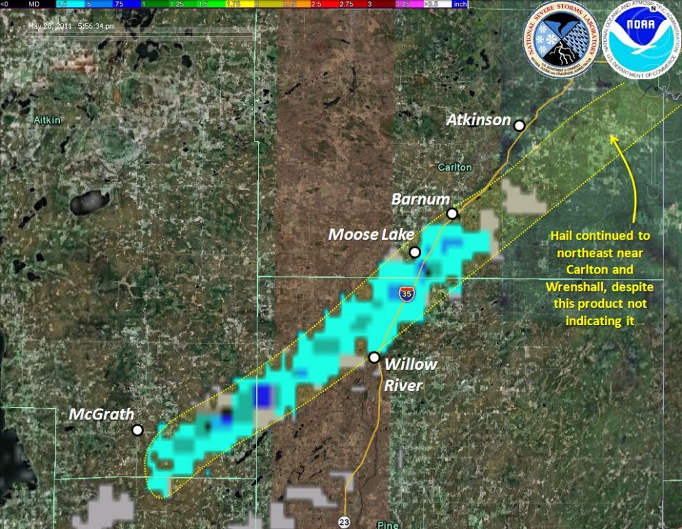 |
A hail swath map from NSSL showing approximately where hail fell with the storm that moved from McGrath all the way into Superior and Duluth. The algorithm that produces this map indicated that the largest hail that fell out of this storm probably fell in far southeast Aitkin County and into the Moose Lake area of far southern Carlton County. We did receive a quarter-size hail report from near Sturgeon Lake in far northern Pine County, at mile marker 212 on Interstate 35. There were also numerous reports of dime to quarter-size hail in Carlton County and numerous reports of pea-size hail in Duluth.
Storm Reports
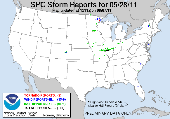
Click the image above for Storm Reports from around the country.
PRELIMINARY LOCAL STORM REPORT...SUMMARY
NATIONAL WEATHER SERVICE DULUTH MN
1052 AM CDT SUN MAY 29 2011

..TIME...   ...EVENT...      ...CITY LOCATION...     ...LAT.LON...
..DATE...   ....MAG....      ..COUNTY LOCATION..ST.. ...SOURCE....
            ..REMARKS..

0230 PM     TSTM WND DMG     6 S TOWER               47.72N 92.29W
05/28/2011                   ST. LOUIS          MN   LAW ENFORCEMENT

            CORRECTED TIME. TREE BLOWN DOWN BLOCKING HIGHWAY 135 NEAR
            HIGHWAY 26. LAKE COUNTY SHERIFFS OFFICE.

0245 PM     HAIL             14 W ISABELLA           47.62N 91.66W
05/28/2011  E0.75 INCH       LAKE               MN   TRAINED SPOTTER

            SOME GUSTY WINDS ACCOMPANIED THE HAIL.

0258 PM     TSTM WND DMG     5 ESE ELY               47.88N 91.75W
05/28/2011                   LAKE               MN   PUBLIC

            A COUPLE TREES BLOWN DOWN ALONG THE KAWISHIWI TRAIL

0304 PM     TSTM WND DMG     7 NE WALES              47.30N 91.64W
05/28/2011                   LAKE               MN   NWS STORM SURVEY

            SOME TREES AND TREE LIMBS BLOWN DOWN IN AN AREA BETWEEN
            MARBLE LAKE AND KANE LAKE. LIKELY ASSOCIATED WITH A
            DOWNBURST BEFORE A TORNADO FORMED JUST EAST.

0307 PM     TORNADO          8 NE WALES              47.31N 91.62W
05/28/2011  F0               LAKE               MN   NWS STORM SURVEY

            TREE DAMAGE WAS NOTED ALONG A 1.9 MILE LONG PATH IN THE
            SUPERIOR NATIONAL FOREST ALONG FOREST ROUTE 107. THIS
            CONSISTED OF A FEW SNAPPED AND UPROOTED TREES...ALONG
            WITH BROKEN TREE LIMBS. PATH WIDTH 350 YARDS. LASTED
            APPROX 3 MINUTES. RATED AN EF-0 ON ENHANCED FUJITA SCALE
            WITH EST PEAK WINDS 70 TO 80 MPH.

0311 PM     TSTM WND GST     HIBBING                 47.40N 92.95W
05/28/2011  M47.00 MPH       ST. LOUIS          MN   ASOS

            47 MPH WIND GUST REPORTED AT THE HIBBING ASOS AT 311 PM.

0320 PM     TSTM WND DMG     7 WNW SILVER BAY        47.33N 91.43W
05/28/2011                   LAKE               MN   NWS STORM SURVEY

            SOME SPORADIC MINOR TREE DAMAGE ALONG HIGHWAY 15. SOME
            BROKEN TREE LIMBS AND A FEW TREES BLOWN DOWN.

0325 PM     FUNNEL CLOUD     5 W SILVER BAY          47.29N 91.39W
05/28/2011                   LAKE               MN   TRAINED SPOTTER

            ROTATING WALL CLOUD WITH BRIEF FUNNELS OR VORTICIES
            DIPPING OUT OF THE BASE OF THE CLOUD. NO CONTACT WITH THE
            GROUND HAS BEEN OBSERVED.

0328 PM     TSTM WND DMG     4 NNW SILVER BAY        47.34N 91.32W
05/28/2011                   LAKE               MN   NWS STORM SURVEY

            SOME TREE LIMBS BROKEN OFF NEAR LAX LAKE.


0328 PM     HAIL             5 N SILVER BAY          47.36N 91.28W
05/28/2011  E1.00 INCH       LAKE               MN   TRAINED SPOTTER

0332 PM     FUNNEL CLOUD     4 N SILVER BAY          47.35N 91.29W
05/28/2011                   LAKE               MN   PARK/FOREST SRVC

            LOW HANGING...ROTATING FUNNEL / CLOUDS OBSERVED PASSING
            OVER LAX LAKE ON WEST SIDE OF TETTEGOUCHE STATE PARK.
            TIME IS ESTIMATED.

0335 PM     FUNNEL CLOUD     3 N SILVER BAY          47.34N 91.28W
05/28/2011                   LAKE               MN   TRAINED SPOTTER

            FUNNEL CLOSER TO THE GROUND. FROM PREVIOUS REPORT 10
            MINUTES AGO.

0335 PM     TSTM WND DMG     GILBERT                 47.49N 92.46W
05/28/2011                   ST. LOUIS          MN   LAW ENFORCEMENT

            TREE DOWN IN GILBERT. LAKE COUNTY SHERIFFS OFFICE.

0340 PM     HAIL             1 W ILLGEN CITY         47.35N 91.20W
05/28/2011  E0.75 INCH       LAKE               MN   PARK/FOREST SRVC

            SOME GUSTY WINDS AND HEAVY RAIN WITH THE HAIL.

0345 PM     FUNNEL CLOUD     2 ESE ILLGEN CITY       47.34N 91.15W
05/28/2011                   LSZ142             MN   PARK/FOREST SRVC

            LOW HANGING...ROTATING FUNNEL / CLOUDS OBSERVED OVER LAKE
            SUPERIOR FROM NEAR THE MOUTH OF THE BAPTISM RIVER.

0350 PM     TSTM WND DMG     2 N SIDE LAKE           47.69N 93.02W
05/28/2011                   ST. LOUIS          MN   LAW ENFORCEMENT

            THREE TREES DOWN BLOCKING HIGHWAY 5 AND PERCH LAKE ROAD.
            LAKE COUNTY SHERIFFS OFFICE.

0450 PM     HAIL             1 W ILLGEN CITY         47.35N 91.20W
05/28/2011  E0.88 INCH       LAKE               MN   PARK/FOREST SRVC

            JUST UNDER QUARTER SIZE.

0530 PM     HAIL             4 S STONE LAKE          45.79N 91.54W
05/28/2011  E0.50 INCH       WASHBURN           WI   TRAINED SPOTTER

            DIME SIZE HAIL

0538 PM     HAIL             2 ENE STURGEON LAKE     46.39N 92.72W
05/28/2011  E1.00 INCH       PINE               MN   TRAINED SPOTTER

            CORRECTED TIME AND SPECIFIC LOCATION. REPORTED AT MILE
            MARKER 212 ON I-35.

0545 PM     HAIL             3 ESE MOOSE LAKE        46.43N 92.71W
05/28/2011  E1.00 INCH       CARLTON            MN   PARK/FOREST SRVC

            0.5 TO 1.0 INCH DIAMETER HAIL. BIGGEST HAIL STONES WERE
            AROUND THE SIZE OF A QUARTER. SOME GUSTY WINDS. AT MOOSE
            LAKE STATE PARK.

0545 PM     HAIL             1 SE MOOSE LAKE         46.44N 92.75W
05/28/2011  E0.88 INCH       CARLTON            MN   TRAINED SPOTTER

0608 PM     HAIL             1 W WRENSHALL           46.62N 92.40W
05/28/2011  E0.75 INCH       CARLTON            MN   TRAINED SPOTTER

            MARBLE TO DIME SIZE HAIL.

0612 PM     HAIL             CARLTON                 46.66N 92.42W
05/28/2011  E0.75 INCH       CARLTON            MN   AMATEUR RADIO

0615 PM     HAIL             NEW DULUTH              46.68N 92.21W
05/28/2011  E0.50 INCH       ST. LOUIS          MN   TRAINED SPOTTER

            ALSO SOME GUSTY WINDS WITH A SWING SET AND SOME SMALL
            TREE BRANCHES BLOWN DOWN.

0619 PM     HAIL             GARY NEW DULUTH         46.68N 92.21W
05/28/2011  E0.75 INCH       ST. LOUIS          MN   AMATEUR RADIO
 |
Media use of NWS Web News Stories is encouraged! Please acknowledge the NWS as the source of any news information accessed from this site. |
|

