
A storm and trailing cold front will continue to slowly move through the Gulf Coast and Southeast U.S. through this weekend with widespread rain showers and isolated thunderstorms. Some snow and a wintry mix is occurring today to the north. A fast-moving clipper storm may bring several inches of snow to the north-central Plains, Midwest, eastern Great Lakes, and Northeast regions this weekend. Read More >
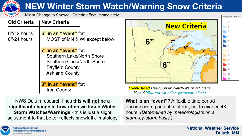
Effective immediately, the National Weather Service Duluth MN Forecast Office will implement new Winter Storm Watch/Warning Criteria for Heavy Snow across its County Warning Area of responsibility. This is part of a national effort to remove non-meteorological discontinuities across County Warning Areas and to better align watch/warning snowfall criteria to the local climatology of the region.
Historically the National Weather Service Duluth MN County Warning Area snowfall criteria was partitioned into different 12- hour and 24- hour criteria. The new criteria will no longer be dependent on the time-frame of the snowfall, allowing for a more event-driven approach to messaging. This new paradigm maintains and encourages the ability to issue or withhold watches and warnings in anticipation of expected impacts or lack thereof.
The new Winter Storm Watch/Warning Criteria for Heavy Snow will be the following:
* 6 inches of snowfall during a winter storm event for zones listed in Table 1
* 7 inches of snowfall during a winter storm event for zones listed in Table 2
* 8 inches of snowfall during a winter storm event for zones listed in Table 3
Table 1: Universal Geographic Codes (UGC): Weather Zones included in the 6 inch Warning Snowfall Criteria
_ _ _ _ _ _ _ _ _ _ _ _ _ _ _ _ _ _ _ _ _ _ _
MNZ010: Koochiching
MNZ018: North Itasca
MNZ026: South Itasca
MNZ025: North Cass
MNZ033: South Cass
MNZ034: Crow Wing
MNZ035: North Aitkin
MNZ036: South Aitkin
MNZ011: North St Louis
MNZ012: Northern Cook/Northern Lake
MNZ019: Central St Louis
MNZ037: Carlton/South St Louis
MNZ038: Pine
WIZ001: Douglas
WIZ006: Burnett
WIZ007: Washburn
WIZ008: Sawyer
WIZ009: Price
Table 2: Universal Geographic Codes (UGC): Weather Zones included in the 7 inch Warning Snowfall Criteria
_ _ _ _ _ _ _ _ _ _ _ _ _ _ _ _ _ _ _ _ _ _ _
MNZ020: Southern Lake/North Shore
MNZ021: Southern Cook/North Shore
WIZ003: Bayfield
WIZ004: Ashland
Table 3: Universal Geographic Codes (UGC): Weather Zones included in the 8 inch Warning Snowfall Criteria
_ _ _ _ _ _ _ _ _ _ _ _ _ _ _ _ _ _ _ _ _ _ _
WIZ004: Iron
A map of the criteria across the entire Contiguous United States can be found at this link: www.weather.gov/snow-criteria
There will be no changes to the Winter Weather Advisory snowfall criteria.
For any questions, please contact:
Joseph Moore, Warning Coordination Meteorologist
joseph.moore@noaa.gov, 218-729-6483 x726

