Overview
|
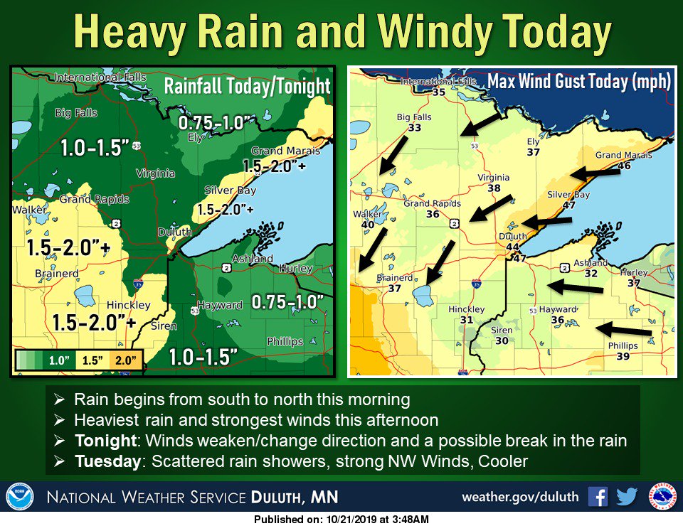
An intense area of low pressure approached the region through the day on Monday, October 21st, producing increasingly strong east to northeast winds. The winds increased through the day, and were especially strong coming off Lake Superior into the Twin Ports area. Peak wind speeds topped 70 MPH at some of the bridges and waves caused damage along many of the lake shore areas. In addition, the strong winds knocked down trees and power lines down leading to power outages. The Duluth Water Level Observation Station located in the Duluth harbor operated by NOAA/National Ocean Service, may have broken an all-time record at 604.75' topping the previous record of 604.42' recorded in 1985. Other unique impacts included:
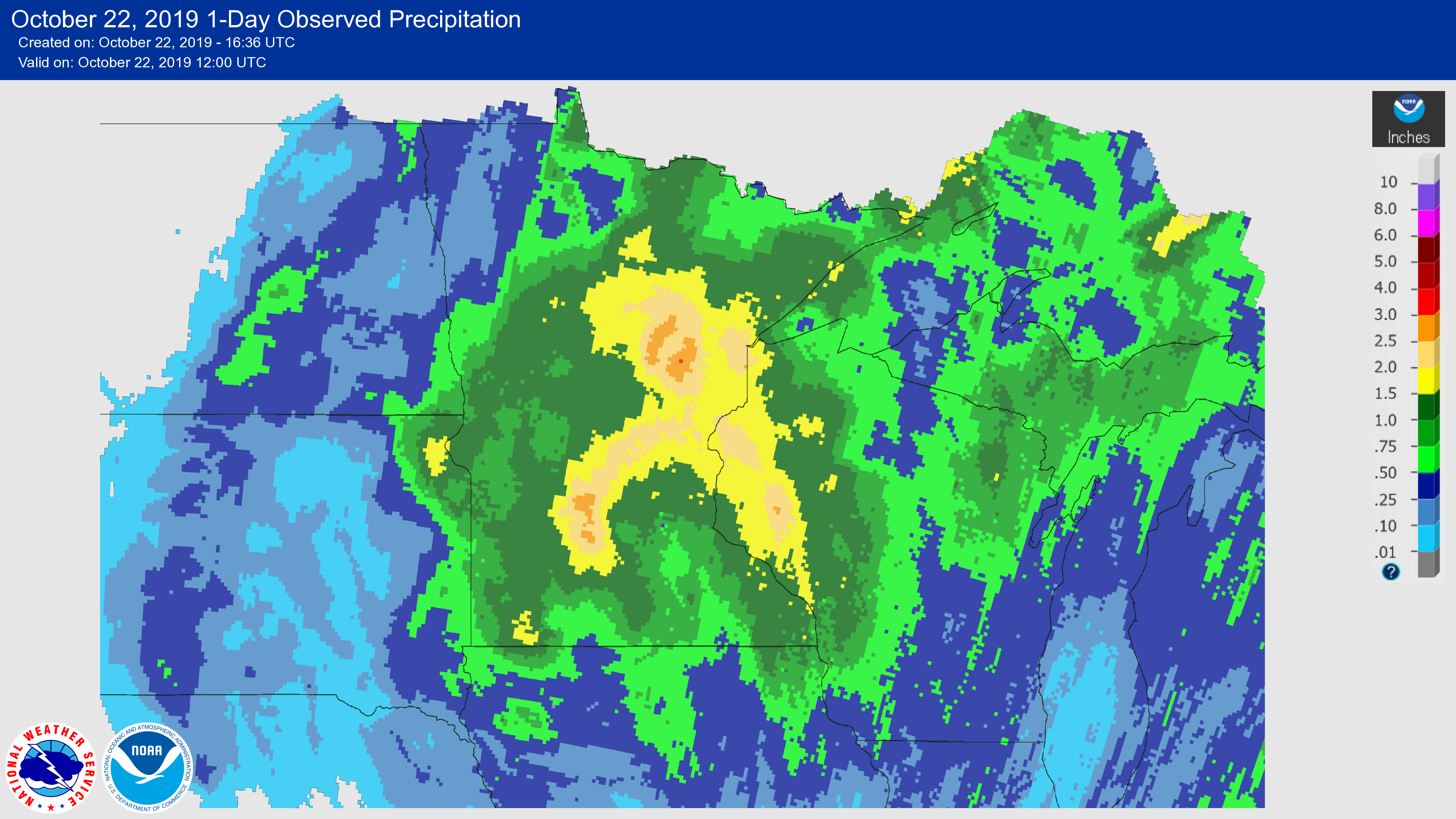
Fairly widespread rains of 1 to over 3 inches of rain fell leading to some ponding, localized flooding, and rises on area rivers. |
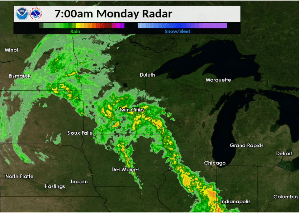 Radar loop from October 21st |
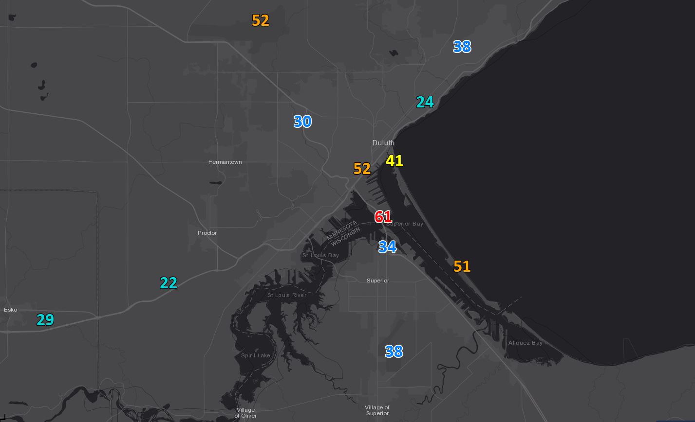
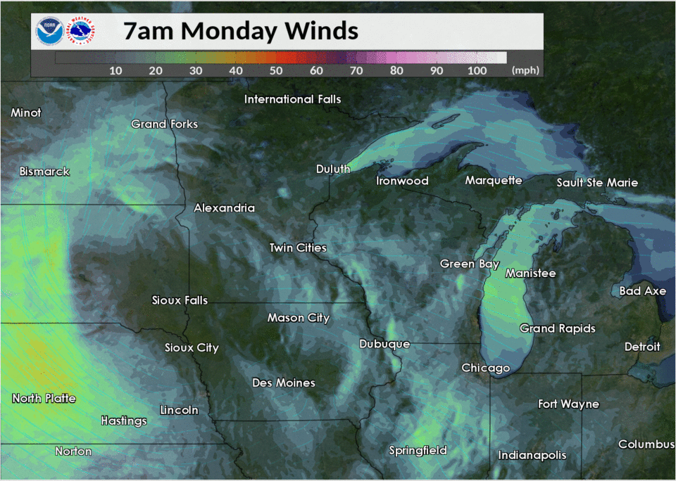
Peak Wind Reports:
 |
 |
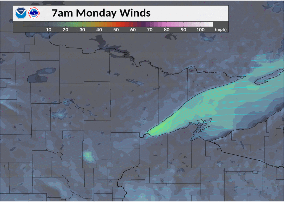 |
| Peak wind gusts around the Twin Ports area | Loop from October 21st showing areas of highest winds move through the area. | Zoomed in version of strongest wind cores from October 21st. (Notice how the strongest winds peak over western Lake Superior during the afternoon hours.) |
Public Information Statement
National Weather Service Duluth MN
533 PM CDT Mon Oct 21 2019

...WIND REPORTS 30 MPH OR HIGHER DURING THE PAST 12 HOURS...

Location                     Speed     Time/Date       Lat/Lon
--------                     -----     ---------       -------
Blatnik Bridge               74 MPH    0415 PM 10/21   46.75N/92.10W
Duluth RWIS                  65 MPH    0310 PM 10/21   46.77N/92.11W
Duluth Airport               61 MPH    0227 PM 10/21   46.85N/92.20W
12 NE Sand Bay               60 MPH    0300 PM 10/21   47.08N/90.73W
Sky Harbor Airport           59 MPH    0256 PM 10/21   46.72N/92.03W
Thompson Hill I-35 Mile Post 56 MPH    0210 PM 10/21   46.72N/92.25W
Cass Lake US-2 Mile Post 131 53 MPH    0520 PM 10/21   47.37N/94.48W
Silver Cliff MN-61 Mile Post 53 MPH    0330 PM 10/21   47.07N/91.59W
Duluth, MN                   52 MPH    0230 PM 10/21   46.78N/92.09W
Bayfield                     49 MPH    0315 PM 10/21   46.80N/90.80W
Chisholm-Hibbing Airport     49 MPH    0500 PM 10/21   47.38N/92.83W
Grand Marais                 47 MPH    0356 PM 10/21   47.74N/90.35W
4 NE Duluth                  46 MPH    0337 PM 10/21   46.83N/92.04W
Cloquet Airport              46 MPH    0416 PM 10/21   46.70N/92.50W
Atkinson Bridge I-35 Mile Po 45 MPH    0411 PM 10/21   46.63N/92.53W
Ashland Airport              44 MPH    0204 PM 10/21   46.55N/90.92W
Winton                       43 MPH    0520 PM 10/21   47.98N/91.43W
6 WSW Beaver Bay             43 MPH    0256 PM 10/21   47.20N/91.40W
Esko                         42 MPH    0130 PM 10/21   46.70N/92.34W
Blatnick Bridge South Abutme 42 MPH    0151 PM 10/21   46.73N/92.10W
Two Harbors                  41 MPH    0121 PM 10/21   47.03N/91.67W
Walker Airport               41 MPH    0115 PM 10/21   47.13N/94.65W
Anderson Road RWIS           41 MPH    0410 PM 10/21   46.79N/92.16W
Grand Marais Airport         40 MPH    0456 PM 10/21   47.83N/90.37W
Eveleth-Virginia Airport     40 MPH    0459 PM 10/21   47.42N/92.50W
Two Harbors                  40 MPH    0255 PM 10/21   47.03N/91.75W
1 W Bayfield                 39 MPH    0309 PM 10/21   46.81N/90.85W
Hibbing                      39 MPH    0507 PM 10/21   47.39N/92.83W
Pine River Airport           39 MPH    0355 PM 10/21   46.72N/94.37W
Twig MN-53 Mile Post 21      38 MPH    0511 PM 10/21   46.92N/92.41W
Saginaw RAWS                 38 MPH    0508 PM 10/21   46.84N/92.46W
Cass Lake DNR                37 MPH    0501 PM 10/21   47.38N/94.61W
La Pointe                    37 MPH    0346 PM 10/21   46.70N/90.80W
Fernberg RAWS                37 MPH    0413 PM 10/21   47.95N/91.50W
Brainerd Airport             37 MPH    0227 PM 10/21   46.40N/94.13W
Hayward Airport              37 MPH    0105 PM 10/21   46.02N/91.45W
Mitchell Bridge MN-169 Mile  37 MPH    0440 PM 10/21   47.45N/92.89W
Chippewa Port No. 1          37 MPH    0459 PM 10/21   47.01N/94.51W
Duluth 2 NNE                 36 MPH    0307 PM 10/21   46.81N/92.08W
La Pointe Airport            36 MPH    0315 PM 10/21   46.78N/90.77W
1.5 E La Pointe (NWS/FAA)    36 MPH    0315 PM 10/21   46.79N/90.76W
Washburn RAWS                35 MPH    0302 PM 10/21   46.59N/91.26W
Brainerd RAWS                34 MPH    0406 PM 10/21   46.40N/94.13W
Northome RWIS                34 MPH    0505 PM 10/21   47.60N/94.13W
Grand Portage                33 MPH    0515 PM 10/21   47.97N/89.69W
Duluth 1.8 NE                33 MPH    0446 PM 10/21   46.80N/92.07W
International Falls          33 MPH    0419 PM 10/21   48.57N/93.40W
Pliny MN-65 Mile Post 98     33 MPH    0440 PM 10/21   46.34N/93.26W
4 SE Breezy Point            32 MPH    0402 PM 10/21   46.54N/94.17W
Odanah                       32 MPH    0330 PM 10/21   46.60N/90.66W
Grand Portage                32 MPH    0444 PM 10/21   47.95N/89.78W
Grand Rapids Airport         32 MPH    0430 PM 10/21   47.22N/93.52W
McGregor Airport             32 MPH    1239 PM 10/21   46.62N/93.32W
Moose Lake Airport           32 MPH    0137 PM 10/21   46.42N/92.80W
Solon Springs Airport        32 MPH    0215 PM 10/21   46.30N/91.82W
Grand Portage RWIS           32 MPH    0400 PM 10/21   47.98N/89.69W
Minong RAWS                  32 MPH    0203 PM 10/21   46.14N/91.98W
Rice Lake N.W.R.             32 MPH    0252 PM 10/21   46.54N/93.29W
Superior Qd No. 4            32 MPH    0342 PM 10/21   47.98N/89.97W
Schroeder                    31 MPH    1215 PM 10/21   47.47N/91.02W
Longville Airport            31 MPH    0452 PM 10/21   46.98N/94.20W
Robinson Lake                31 MPH    0250 PM 10/21   47.85N/92.05W
Moose Lake RAWS              31 MPH    0308 PM 10/21   46.42N/92.80W
Smith Rapids                 31 MPH    1047 AM 10/21   45.93N/90.18W
Hinckley                     30 MPH    1110 AM 10/21   45.97N/93.00W
Ely                          30 MPH    0204 PM 10/21   47.83N/91.84W
Lakeside                     30 MPH    0332 PM 10/21   46.64N/91.92W
Cook Airport                 30 MPH    0516 PM 10/21   47.82N/92.68W
Ely Airport                  30 MPH    0519 PM 10/21   47.82N/91.82W
Margie US-71 Mile Post 379   30 MPH    0401 PM 10/21   48.13N/93.88W
Seagull Lake RAWS            30 MPH    0404 PM 10/21   48.12N/90.84W

Observations are collected from a variety of sources with varying
equipment and exposures. We thank all volunteer weather observers
for their dedication. Not all data listed are considered official.
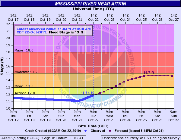
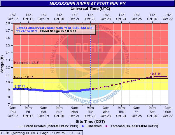
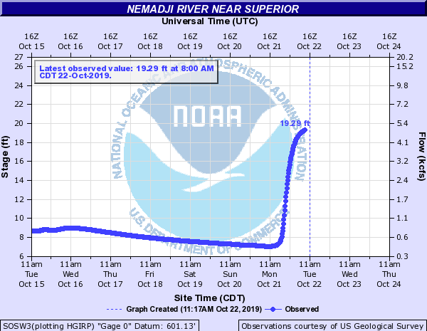
Rivers / Flooding
Hydrographs
 |
 |
 |
|
| Hydrograph for Mississippi River at Atkins, MN | Hydrograph for Mississippi River at Fort Ripley, MN | Hydrograph for Nemadji River near Superior, WI |
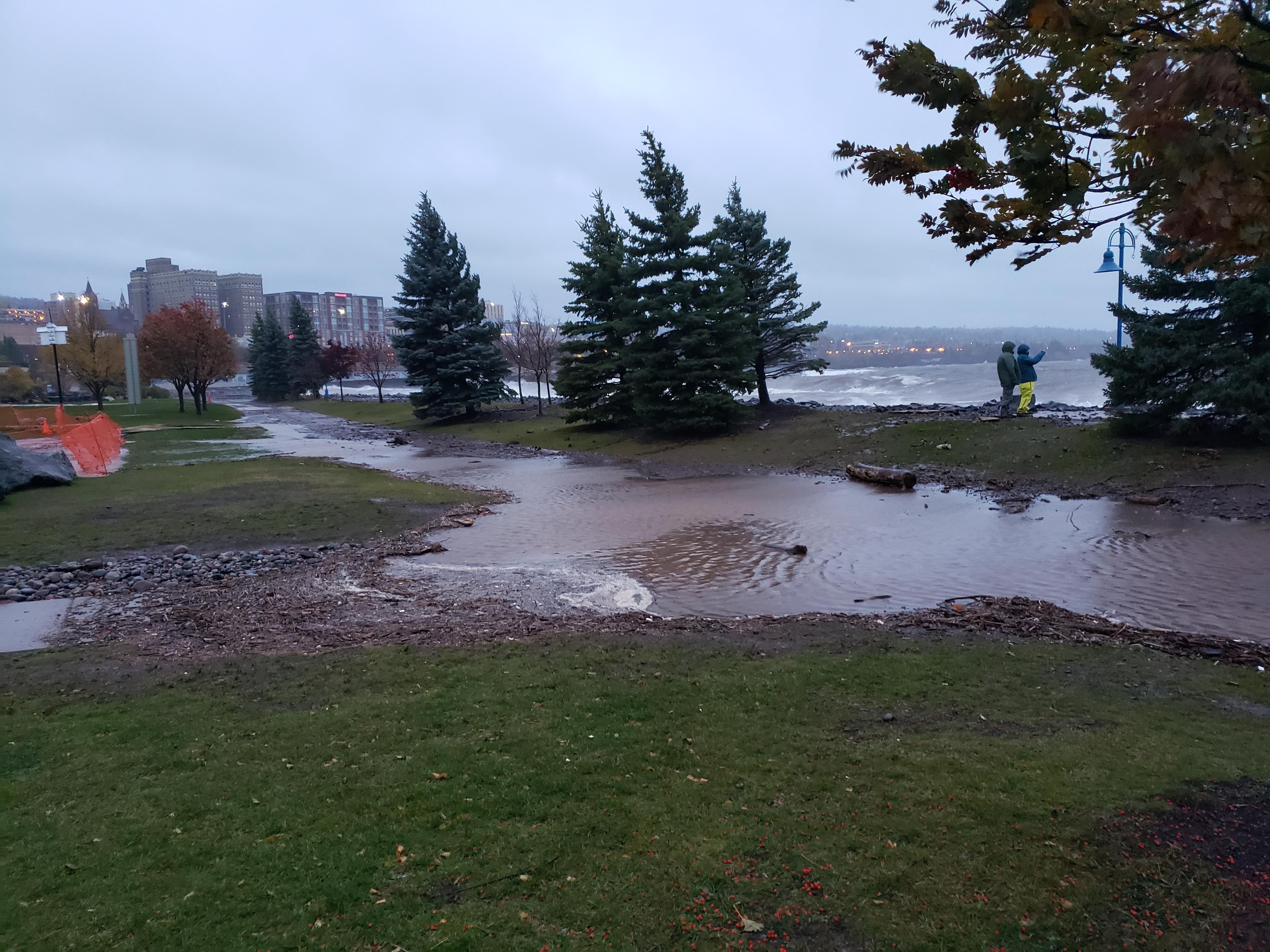
Photos / Animations:
 |
 |
 |
 |
| Lake shore flooding in Canal Park - Duluth (NWS Photo) |
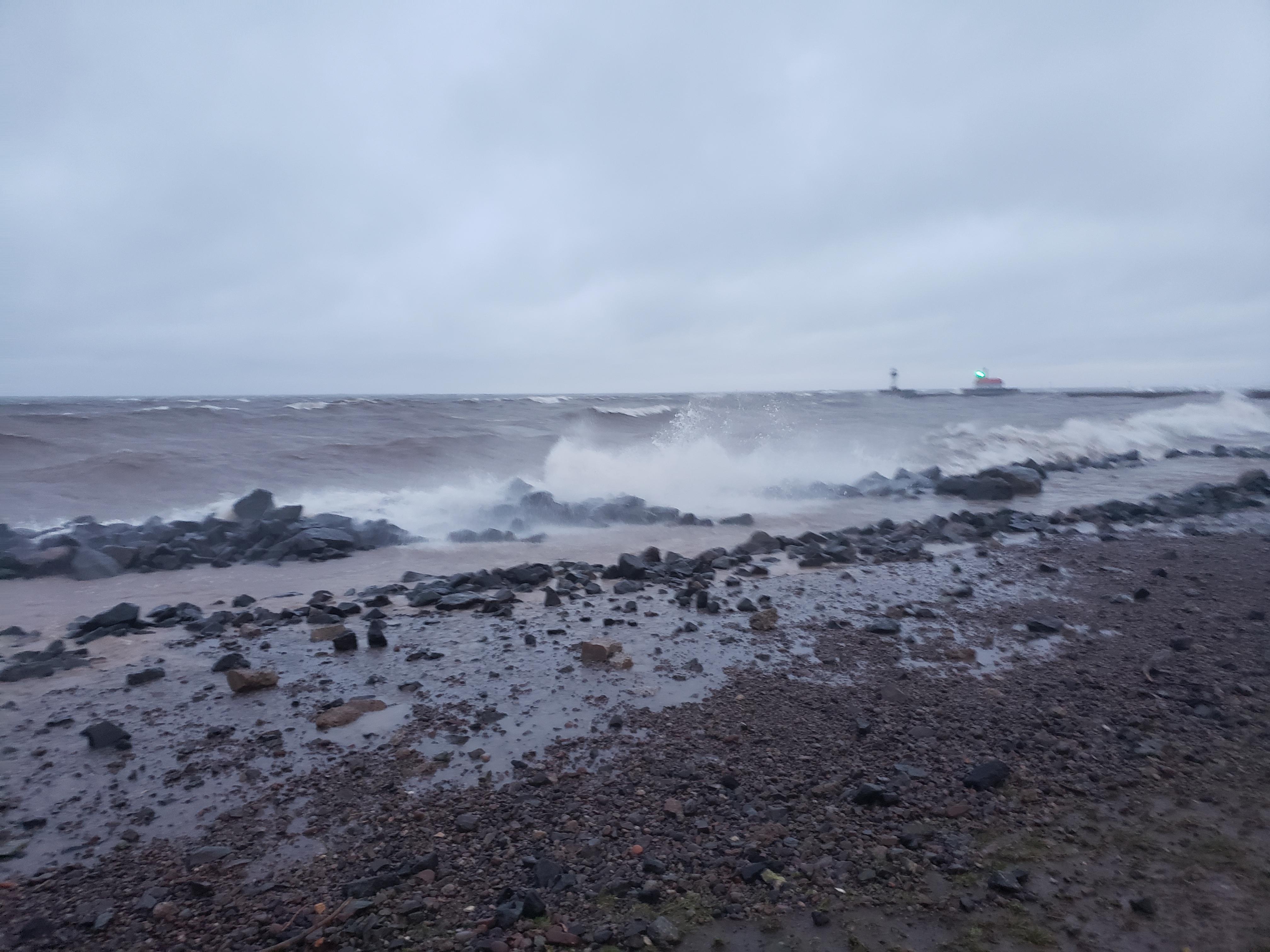
High waves at Canal Park - Duluth (NWS Photo) |
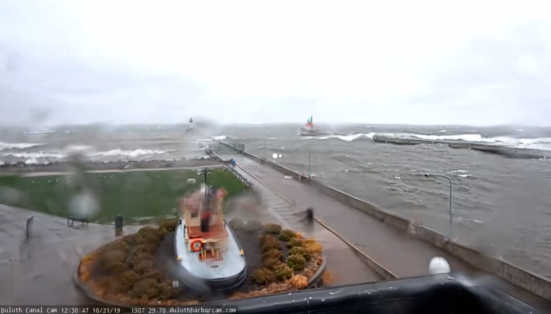
Wave action at Canal Park - Duluth around Noon on Oct.21 (Duluth Harbor Webcam) |
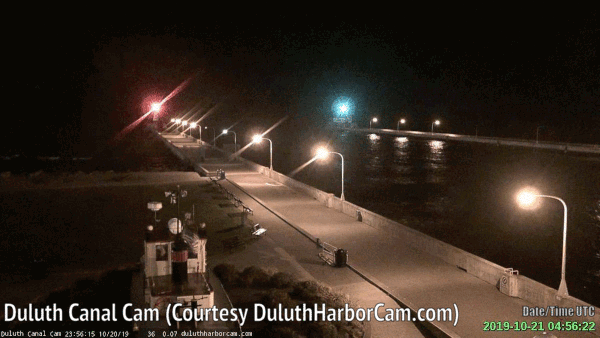
Animation of Duluth Harbor Canal Park webcam images from Oct.21. (Duluth Harbor Webcam) |
 |
|||
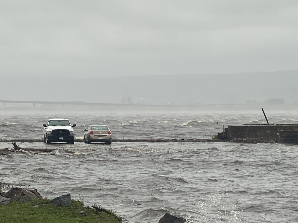
| Flooding at Midwest Energy coal dock parking area on the St.Louis River. (NWS Photo) |
Rainfall Totals:
Public Information Statement
National Weather Service Duluth MN
444 AM CDT Tue Oct 22 2019

...24 HOURS RAINFALL AMOUNTS...

Location                     Amount    Time/Date       Lat/Lon
5 N Hackensack Chippewa RAWS 3.05 in   0359 AM 10/22   47.01N/94.51W
Sandstone 6 W USCRN Site     2.53 in   0100 AM 10/22   46.11N/92.99W
8 N Remer Chippewa RAWS      2.37 in   0315 AM 10/22   47.18N/93.96W
Rice Lake N.W.R.             2.26 in   0352 AM 10/22   46.54N/93.29W
0.5 E Floodwood              2.11 in   0300 AM 10/22   46.93N/92.90W
Cloquet River nr Burnett     2.06 in   0330 AM 10/22   46.90N/92.52W
Hinckley                     2.03 in   0420 AM 10/22   45.97N/93.00W
3.8 S Swan River             1.98 in   0300 AM 10/22   47.03N/93.19W
Saginaw RAWS                 1.97 in   0408 AM 10/22   46.84N/92.46W
12 W Grand Portage RAWS      1.97 in   0242 AM 10/22   47.98N/89.97W
1.8 E Cohasset               1.92 in   0245 AM 10/22   47.25N/93.59W
2.4 S Meadowlands            1.92 in   0300 AM 10/22   47.04N/92.74W
Beaver R nr Beaver Bay       1.89 in   0200 AM 10/22   47.27N/91.31W
St. Croix RAWS               1.88 in   0315 AM 10/22   45.97N/92.62W
2.3 SE Ball Club             1.87 in   0400 AM 10/22   47.30N/93.90W
Hill City                    1.86 in   0407 AM 10/22   46.96N/93.60W
Bruno                        1.86 in   0430 AM 10/22   46.28N/92.66W
Siren                        1.81 in   0415 AM 10/22   45.82N/92.37W
1.5 S Pleasant Valley        1.80 in   0345 AM 10/22   46.52N/92.39W
Saginaw                      1.78 in   0426 AM 10/22   46.85N/92.47W
Isabella                     1.77 in   0404 AM 10/22   47.62N/91.38W
Grand Rapids Airport         1.77 in   0425 AM 10/22   47.22N/93.52W
Lind                         1.76 in   0406 AM 10/22   45.74N/92.80W
Moose Lake RAWS              1.74 in   0408 AM 10/22   46.42N/92.80W
Cass Lake DNR                1.73 in   0401 AM 10/22   47.38N/94.61W
Grand Portage                1.73 in   0416 AM 10/22   47.97N/89.69W
Cutfoot RAWS                 1.67 in   0404 AM 10/22   47.54N/94.05W
Breezy Point                 1.67 in   0427 AM 10/22   46.58N/94.24W
Esko                         1.66 in   0415 AM 10/22   46.70N/92.34W
4.6 N Taconite               1.65 in   0300 AM 10/22   47.39N/93.38W
Danbury                      1.61 in   0425 AM 10/22   45.95N/92.31W
Grand Portage                1.60 in   0244 AM 10/22   47.95N/89.78W
5 SE Duxbury                 1.59 in   0430 AM 10/22   46.06N/92.46W
Brainerd RAWS                1.58 in   0406 AM 10/22   46.40N/94.13W
Federal Dam 3 WNW            1.58 in   0345 AM 10/22   47.25N/94.22W
0.7 N Aitkin                 1.56 in   0300 AM 10/22   46.54N/93.71W
Deer River                   1.55 in   0415 AM 10/22   47.40N/93.62W
Brainerd Airport             1.53 in   0420 AM 10/22   46.40N/94.13W
5.9 N Brevik                 1.52 in   0300 AM 10/22   47.17N/94.29W
Walker Airport               1.51 in   0415 AM 10/22   47.13N/94.65W
1.6 SE Mission               1.50 in   0230 AM 10/22   46.57N/94.03W
Minong RAWS                  1.50 in   0403 AM 10/22   46.14N/91.98W
Libby                        1.48 in   0300 AM 10/22   46.79N/93.32W
Brule River nr Hovland       1.47 in   0200 AM 10/22   47.82N/90.05W
Boy River nr Boy River       1.46 in   0300 AM 10/22   47.08N/94.10W
Schroeder                    1.44 in   0425 AM 10/22   47.47N/91.02W
Hayward Airport              1.43 in   0353 AM 10/22   46.02N/91.45W
3.4 SE Little Swan           1.43 in   0300 AM 10/22   47.25N/92.81W
Effie                        1.42 in   0407 AM 10/22   47.78N/93.65W
NWS Duluth                   1.36 in   0100 AM 10/22   46.84N/92.21W
Nashwauk 11.5 N              1.35 in   0400 AM 10/22   47.55N/93.19W
Littlefork                   1.31 in   0245 AM 10/22   48.40N/93.55W
Hayward RAWS                 1.30 in   0403 AM 10/22   46.00N/91.50W
10 NE Merrifield             1.29 in   0429 AM 10/22   46.59N/94.10W
Duluth Airport               1.28 in   0425 AM 10/22   46.85N/92.20W
1.5 SW Willow River          1.23 in   0300 AM 10/22   46.31N/92.86W
0.6 E Scanlon                1.23 in   0300 AM 10/22   46.70N/92.42W
0.5 NW Palmers               1.22 in   0330 AM 10/22   46.93N/91.86W
Skibo RAWS                   1.19 in   0422 AM 10/22   47.49N/91.99W
Duluth 1.8 NE                1.17 in   0415 AM 10/22   46.80N/92.07W
Big Fork at Big Falls        1.16 in   0315 AM 10/22   48.20N/93.81W
Two Harbors                  1.16 in   0423 AM 10/22   47.03N/91.67W
Northome                     1.15 in   0416 AM 10/22   47.88N/94.25W
Hibbing                      1.15 in   0407 AM 10/22   47.39N/92.83W
2 N French River             1.13 in   0429 AM 10/22   46.94N/91.90W
Lakeside                     1.09 in   0415 AM 10/22   46.64N/91.92W
3.2 SE Lennox                1.09 in   0300 AM 10/22   46.20N/94.32W
South Range                  1.08 in   0429 AM 10/22   46.55N/91.95W
Chisholm-Hibbing Airport     1.08 in   0422 AM 10/22   47.38N/92.83W
Lutsen                       1.05 in   0215 AM 10/22   47.64N/90.71W
4.4 SE Babbitt               1.02 in   0345 AM 10/22   47.67N/91.86W
3.1 NE Jenkins               1.02 in   0300 AM 10/22   46.69N/94.30W
International Falls          1.01 in   0355 AM 10/22   48.57N/93.40W
Colvin Creek nr Hoyt Lakes   1.00 in   0315 AM 10/22   47.53N/92.00W
Storm Reports:
PRELIMINARY LOCAL STORM REPORT
NATIONAL WEATHER SERVICE DULUTH MN
530 PM CDT MON OCT 21 2019

..TIME...   ...EVENT...      ...CITY LOCATION...     ...LAT.LON...
..DATE...   ....MAG....      ..COUNTY LOCATION..ST.. ...SOURCE....
            ..REMARKS..

0415 PM     NON-TSTM WND GST 2 NNW SUPERIOR          46.75N 92.10W
10/21/2019  M74 MPH          LSZ145             WI   MESONET

            MESONET STATION MN081 BLATNIK BRIDGE.

0310 PM     NON-TSTM WND GST 1 SSE DULUTH            46.77N 92.11W
10/21/2019  M65 MPH          ST. LOUIS          MN   MESONET

            MESONET STATION MN082 DULUTH RWIS.

0227 PM     NON-TSTM WND GST 4 NE HERMANTOWN         46.85N 92.20W
10/21/2019  M61 MPH          ST. LOUIS          MN   ASOS

            ASOS STATION KDLH DULUTH AIRPORT.

0300 PM     NON-TSTM WND GST 13 NE SAND BAY          47.08N 90.73W
10/21/2019  M60 MPH          ASHLAND            WI   MESONET

            MESONET STATION DISW3 12 NE SAND BAY.

0256 PM     NON-TSTM WND GST 6 SE DULUTH             46.72N 92.03W
10/21/2019  M59 MPH          ST. LOUIS          MN   AWOS

            AWOS STATION KDYT SKY HARBOR AIRPORT.

0210 PM     NON-TSTM WND GST 2 SSW PROCTOR           46.72N 92.25W
10/21/2019  M56 MPH          ST. LOUIS          MN   MESONET

            MESONET STATION MN080 THOMPSON HILL I-35
            MILE POST 248.

0330 PM     NON-TSTM WND GST 5 ENE TWO HARBORS       47.07N 91.59W
10/21/2019  M53 MPH          LAKE               MN   MESONET

            MESONET STATION MN093 SILVER CLIFF MN-61
            MILE POST 30.

0230 PM     NON-TSTM WND GST 1 ESE DULUTH            46.78N 92.09W
10/21/2019  M52 MPH          ST. LOUIS          MN   BUOY

            BUOY STATION DULM5 DULUTH, MN.

0440 PM     NON-TSTM WND GST 3 W SCHLEY              47.37N 94.48W
10/21/2019  M50 MPH          CASS               MN   MESONET

            MESONET STATION MN061 CASS LAKE US-2 MILE
            POST 131.

0315 PM     NON-TSTM WND GST 1 SE BAYFIELD           46.80N 90.80W
10/21/2019  M49 MPH          LSZ147             WI   MESONET

            MESONET STATION DW6252 BAYFIELD.

0500 PM     NON-TSTM WND GST 5 ESE HIBBING           47.38N 92.83W
10/21/2019  M49 MPH          ST. LOUIS          MN   ASOS

            ASOS STATION KHIB CHISHOLM-HIBBING AIRPORT.

0356 PM     NON-TSTM WND GST 1 S GRAND MARAIS        47.74N 90.35W
10/21/2019  M47 MPH          LSZ141             MN   MESONET

            MESONET STATION KGNA GRAND MARAIS.

0416 PM     NON-TSTM WND GST 2 WSW CLOQUET           46.70N 92.50W
10/21/2019  M46 MPH          CARLTON            MN   AWOS

            AWOS STATION KCOQ CLOQUET AIRPORT.

0337 PM     NON-TSTM WND GST 1 SW LESTER PARK        46.83N 92.04W
10/21/2019  M46 MPH          ST. LOUIS          MN   MESONET

            MESONET STATION FW2111 4 NE DULUTH.

0411 PM     NON-TSTM WND GST 5 WNW SCOTTS CORNER     46.63N 92.53W
10/21/2019  M45 MPH          CARLTON            MN   MESONET

            MESONET STATION MN097 ATKINSON BRIDGE I-35
            MILE POST 231.


&&
Other Graphics
(Being developed...)
 |
 |
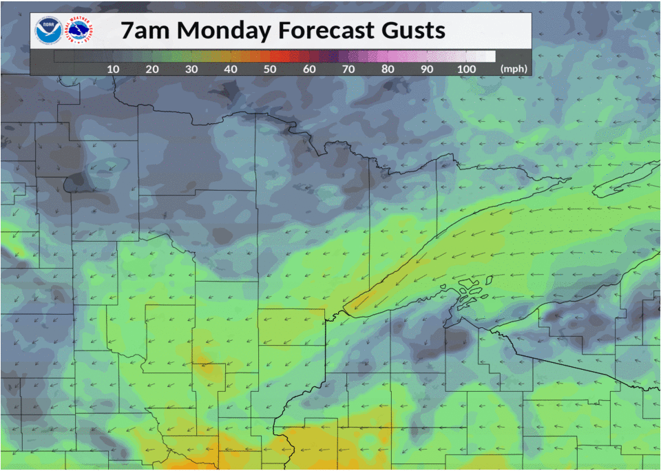 |
| 24-hr rainfall | Weather Story Graphic from Oct.21st | Model display of strongest wind gusts on Oct.21st |
Near-storm environment summary.
| Figure 4: Caption | Figure 5: Caption | Figure 6: Caption |
 |
Media use of NWS Web News Stories is encouraged! Please acknowledge the NWS as the source of any news information accessed from this site. |
|

