|
A strong low pressure system across the Central Plains the morning of April 28, 2014, in conjunction with a strong area of high pressure over Hudson Bay, produced a significant pressure gradient across the Upper Midwest. As a result, strong non-thunderstorm winds were felt across the Northland, especially along the southwest portion of Lake Superior. Many trees were uprooted, and damage was sustained to cars, houses, and fences. |
 Surface Plot from the morning of April 28, 2014 |
Wind Reports
PUBLIC INFORMATION STATEMENT
NATIONAL WEATHER SERVICE DULUTH MN
534 PM CDT MON APR 28 2014


...HIGHEST 24 HOUR WIND REPORTS...

LOCATION                       SPEED     TIME/DATE
1 N KNIFE RIVER                63 MPH    1244 PM 04/28
DULUTH AIRPORT                 55 MPH    1119 AM 04/28
2 SW PROCTOR                   54 MPH    1145 AM 04/28
2 E BIRCHDALE                  52 MPH    0110 PM 04/28
SKY HARBOR AIRPORT             49 MPH    0813 AM 04/28
CLOQUET                        48 MPH    1056 AM 04/28
TWO HARBORS                    46 MPH    0913 AM 04/28
3 SE BAYFIELD                  45 MPH    0452 PM 04/28
SILVER BAY                     45 MPH    1153 AM 04/28
INTERNATIONAL FALLS            45 MPH    1207 PM 04/28
4 SE ARNOLD                    44 MPH    1236 PM 04/28
7 E EFFIE                      43 MPH    0215 PM 04/28
CHISHOLM-HIBBING AIRPORT       43 MPH    1007 AM 04/28
PINE RIVER AIRPORT             43 MPH    0832 PM 04/27
BAYFIELD                       42 MPH    0142 PM 04/28
MCGREGOR  AIRPORT              41 MPH    0908 AM 04/28
4 ENE MARGIE                   40 MPH    0250 PM 04/28
ELY                            40 MPH    0153 AM 04/28
AITKIN                         40 MPH    0513 PM 04/28
BRAINERD AIRPORT               40 MPH    1137 AM 04/28
SUPERIOR                       40 MPH    0935 AM 04/28
 BALL BLUFF RWIS               40 MPH    0940 AM 04/28
2 W INO                        40 MPH    1214 PM 04/28
3 S CHISHOLM                   39 MPH    0635 PM 04/27
CASS LAKE DOT                  38 MPH    0705 PM 04/27
7 N MCGRATH RWIS               37 MPH    0800 AM 04/28
2 NNW SUPERIOR                 37 MPH    1000 AM 04/28
PHILLIPS                       37 MPH    1135 AM 04/28
1 N PORT WING                  37 MPH    0940 PM 04/27
EVELETH-VIRGINIA AIRPORT       36 MPH    1054 AM 04/28
ASHLAND AIRPORT                36 MPH    0244 PM 04/28
COOK                           36 MPH    0115 AM 04/28
2 NE DULUTH                    35 MPH    1116 AM 04/28
6 NW ASH LAKE                  35 MPH    1245 PM 04/28
BIGFORK                        35 MPH    0148 PM 04/28
6 WSW SPIRIT                   35 MPH    1114 AM 04/28
MOOSE LAKE AIRPORT             32 MPH    1254 PM 04/28
1 N GRAND PORTAGE              32 MPH    1250 PM 04/28
HINCKLEY                       32 MPH    0607 PM 04/27
NORTHOME                       32 MPH    0741 AM 04/28
4 WNW WENTWORTH                32 MPH    0211 PM 04/28
LONGVILLE AIRPORT              31 MPH    0616 PM 04/27
ORR                            31 MPH    1233 PM 04/28
2 SW INO                       31 MPH    0900 AM 04/28
HAYWARD                        30 MPH    0619 PM 04/27
GRAND RAPIDS                   30 MPH    0555 PM 04/27


OBSERVATIONS ARE COLLECTED FROM A VARIETY OF SOURCES WITH VARYING
EQUIPMENT AND EXPOSURE. NOT ALL DATA LISTED ARE CONSIDERED OFFICIAL.

$$
Photos
.jpg) |
 |
 |
 |
| Fallen tree on top of car at Morris Thomas Rd and Haines Rd Bobbie Krynicki |
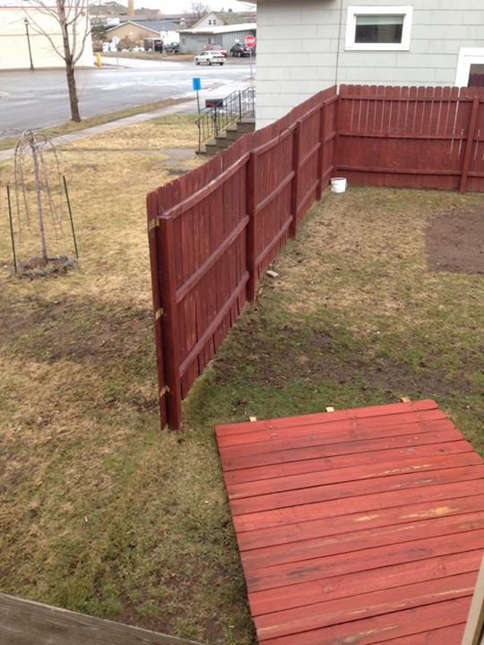
Fence blown down in West Duluth Maureen Hardy |
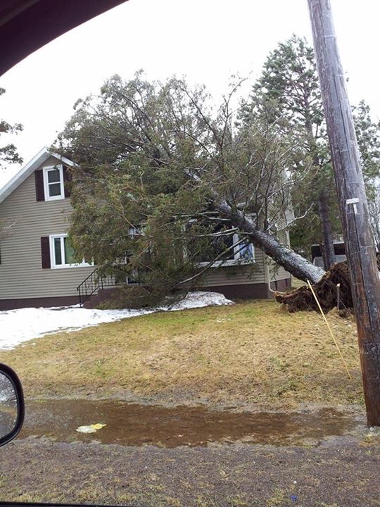
Fallen tree on top of a house across from the Proctor Fairgrounds Justin Fitzsimmons |
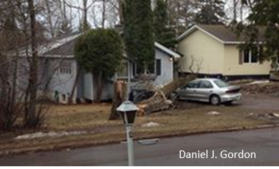
Damage at 41st and Cooke Street in Duluth Daniel J. Gordon |
PRELIMINARY LOCAL STORM REPORT...SUMMARY
NATIONAL WEATHER SERVICE DULUTH MN
147 PM CDT MON APR 28 2014

..TIME...   ...EVENT...      ...CITY LOCATION...     ...LAT.LON...
..DATE...   ....MAG....      ..COUNTY LOCATION..ST.. ...SOURCE....
            ..REMARKS..

1002 AM     NON-TSTM WND DMG 2 NW SCOTTS CORNER      46.62N 92.47W
04/28/2014                   CARLTON            MN   TRAINED SPOTTER

            12-18 INCH BIRCH TREE UPROOTED ON THE SOUTHWEST CORNER OF
            CHUB LAKE

1110 AM     NON-TSTM WND DMG 3 W DULUTH              46.78N 92.17W
04/28/2014                   ST. LOUIS          MN   BROADCAST MEDIA

            TREE DOWN ON A CAR ON MORRIS THOMAS RD OFF HAINES RD

1153 AM     FREEZING RAIN    3 SW DULUTH             46.75N 92.16W
04/28/2014  E0.25 INCH       ST. LOUIS          MN   NWS EMPLOYEE

            1/4 INCH OF ICE ON BUILDINGS, TREES, AND SIGNS FACING THE
            WIND. NO ICE ON THE ROADS. ICE MAY BE LEFT OVER FROM LAST
            NIGHT.

1153 AM     NON-TSTM WND DMG 3 SW DULUTH             46.76N 92.16W
04/28/2014                   ST. LOUIS          MN   NWS EMPLOYEE

            AROUND 15 PINE TREES SNAPPED

1214 PM     NON-TSTM WND DMG PROCTOR                 46.74N 92.23W
04/28/2014                   ST. LOUIS          MN   BROADCAST MEDIA

            TREE FELL ON TOP OF A HOUSE ACROSS THE STREET FROM THE
            PROCTOR FAIRGROUNDS

0105 PM     NON-TSTM WND DMG PROCTOR                 46.74N 92.23W
04/28/2014                   ST. LOUIS          MN   TRAINED SPOTTER

            10 INCH DIAMETER TREE UPROOTED. THIN GLAZE OF ICE ON
            OBJECTS. ICE FLYING THROUGH AIR.

0105 PM     NON-TSTM WND DMG LAKESIDE-LESTER PARK    46.84N 92.03W
04/28/2014                   ST. LOUIS          MN   BROADCAST MEDIA

            A TREE WAS REPORTED TO HAVE FALLEN ON A CAR IN THE
            LAKESIDE NEIGHBORHOOD OF DULUTH NEAR 41ST AVENUE AND
            COOKE STREET.


&&
 |
Media use of NWS Web News Stories is encouraged! Please acknowledge the NWS as the source of any news information accessed from this site. |
|

